Winter Weather Discussion
Moderator: S2k Moderators
Forum rules
The posts in this forum are NOT official forecast and should not be used as such. They are just the opinion of the poster and may or may not be backed by sound meteorological data. They are NOT endorsed by any professional institution or
STORM2K.
-
orangeblood
- S2K Supporter

- Posts: 3822
- Joined: Tue Dec 15, 2009 6:14 pm
- Location: Fort Worth, TX
#2541 Postby orangeblood » Mon Jan 19, 2026 1:34 pm
The warm nose is at the 700 mb level during peak precip on Saturday according to the Euro, thin enough that it could be overcome or majority sleet
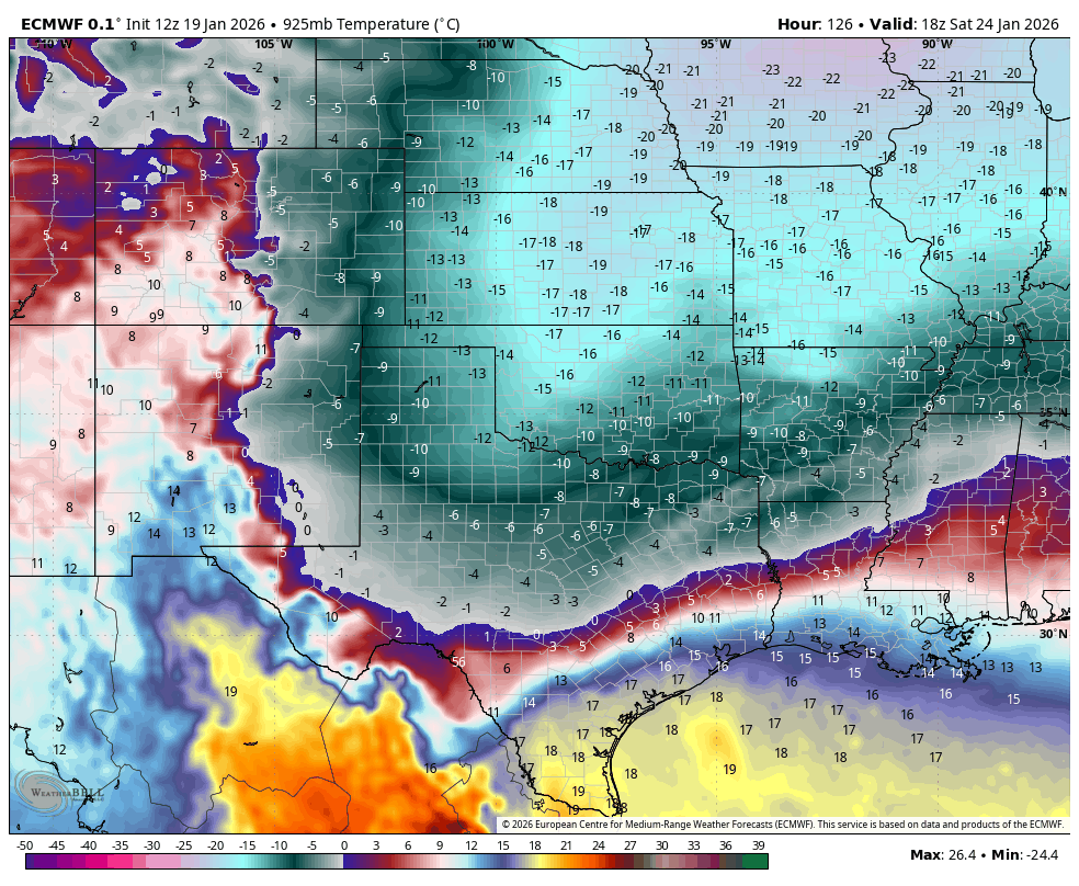
Really cold at 925mb though
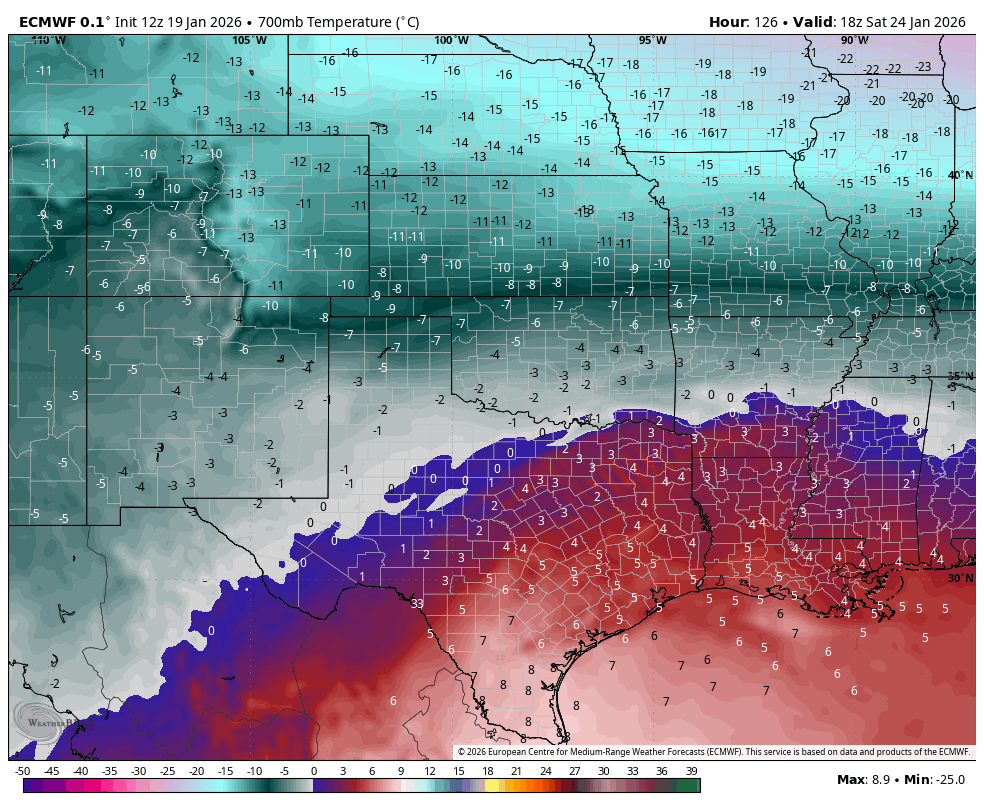
700 mb

3 likes
-
Brent
- S2K Supporter

- Posts: 38601
- Age: 37
- Joined: Sun May 16, 2004 10:30 pm
- Location: Tulsa Oklahoma
-
Contact:
#2542 Postby Brent » Mon Jan 19, 2026 1:34 pm
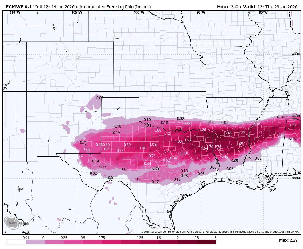
Ntxw wrote:Brent wrote:18 inches of snow in Southern Oklahoma on the Euro
Is this really happening

The qpf trend is more shocking if anything. Within just a few cycles from barely anything to near record anomalies for the period.
Seriously yesterday morning I was looking at half the ensembles without even a flake here. Not even remotely feeling it
This is just unbelievable trends. I never imagined it could flip like this that quick
2 likes
#neversummer
-
orangeblood
- S2K Supporter

- Posts: 3822
- Joined: Tue Dec 15, 2009 6:14 pm
- Location: Fort Worth, TX
#2543 Postby orangeblood » Mon Jan 19, 2026 1:37 pm
Yikes

hope that warm nose isn't took thick

3 likes
-
gpsnowman
- S2K Supporter

- Posts: 3291
- Joined: Fri Jan 07, 2011 10:35 am
- Location: Grand Prairie Tx
#2544 Postby gpsnowman » Mon Jan 19, 2026 1:37 pm
Good grief that is s**t ton of moisture.
2 likes
-
wxman57
- Moderator-Pro Met

- Posts: 23160
- Age: 68
- Joined: Sat Jun 21, 2003 8:06 pm
- Location: Houston, TX (southwest)
#2545 Postby wxman57 » Mon Jan 19, 2026 1:38 pm
Here's a verification of all the model predictions for Houston with a plot of the actual observed temps (red line with boxes). CMC is in blue and dashed blue. UKMET (red line) was too warm. GFS (green) was a bit too warm at the start, but settled in close to reality. ICON (gray line) was also way too cold, but nothing could match the Canadian for being too cold. I saw similar results in each model run and also during the 2021 freeze/ice storm. Toss out the Canadian and ICON here in Houston, at least.
https://wxman57.com/images/Jan2025.jpg
0 likes
-
wxman22
- Category 5

- Posts: 1776
- Joined: Mon Jan 30, 2006 12:39 am
- Location: Wichita Falls, TX
-
Contact:
#2546 Postby wxman22 » Mon Jan 19, 2026 1:42 pm
If the Euro verified we would have an ice storm with a snowstorm on top of the ice here.
2 likes
-
Quixotic
- Category 3

- Posts: 835
- Joined: Tue Feb 14, 2017 12:27 am
- Location: Frisco
#2548 Postby Quixotic » Mon Jan 19, 2026 1:45 pm
Freaking warm nose. I hate it so so much.
6 likes
-
rwfromkansas
- Category 5

- Posts: 2883
- Joined: Sat Aug 27, 2005 12:47 am
- Location: North Fort Worth
#2549 Postby rwfromkansas » Mon Jan 19, 2026 1:46 pm
I hope for a deeper cold layer. Or enough heavy sleet to cool things down. We need a bit of a southern trend here in DFW to help with that. But my word, the moisture is insane. This is a MAJOR storm.
I just don't want what happened a few years ago where I was hoping for a change from sleet to snow that only came at the very end.
Last edited by
rwfromkansas on Mon Jan 19, 2026 1:47 pm, edited 1 time in total.
6 likes
-
BAY29
- Tropical Low

- Posts: 16
- Joined: Fri Jan 02, 2026 10:36 pm
#2551 Postby BAY29 » Mon Jan 19, 2026 1:48 pm
hurricane2025 wrote:Se tx is safe once again
For now
0 likes
-
snownado
- Category 5

- Posts: 1020
- Joined: Sat Dec 09, 2023 7:00 pm
- Location: Plano, TX
#2552 Postby snownado » Mon Jan 19, 2026 1:50 pm
hurricane2025 wrote:Se tx is safe once again
Please stop...
5 likes
-
bubba hotep
- S2K Supporter

- Posts: 5920
- Joined: Wed Dec 28, 2016 1:00 am
- Location: Collin County Texas
#2553 Postby bubba hotep » Mon Jan 19, 2026 1:52 pm
Euro is probably too warm, but this QPF is going to cause trouble with these temps.

6 likes
Winter time post are almost exclusively focused on the DFW area.
-
Brazoria979cnty
- Tropical Low

- Posts: 11
- Joined: Sat Jan 17, 2026 5:45 pm
-
Contact:
#2554 Postby Brazoria979cnty » Mon Jan 19, 2026 1:52 pm
snownado wrote:hurricane2025 wrote:Se tx is safe once again
Please stop...
were still a long ways away lol nothing is set in stone
1 likes
-
DukeMu
- Tropical Depression

- Posts: 96
- Joined: Thu Jun 01, 2023 2:48 pm
- Location: College Station, TX
#2555 Postby DukeMu » Mon Jan 19, 2026 1:53 pm
Stratton23 wrote:This setup looks mainly ice/ sleet, snow looks to stay in north texas as the most likely outcome, though thats subject to change
Gotta get rid of that warm nose.
0 likes
-
Iceresistance
- Category 5

- Posts: 9494
- Age: 22
- Joined: Sat Oct 10, 2020 9:45 am
- Location: Tecumseh, OK/Norman, OK
#2556 Postby Iceresistance » Mon Jan 19, 2026 1:55 pm
KFOR has now forecasted 13 inches of snow for me

1 likes
Bill 2015 & Beta 2020
Winter 2020-2021 
All observations are in Tecumseh, OK unless otherwise noted.
Winter posts are focused mainly for Oklahoma & Texas.
Take any of my forecasts with a grain of salt, refer to the NWS, SPC, and NHC for official information
Never say
Never with weather! Because
ANYTHING is possible!
-
Stratton23
- Category 5

- Posts: 3371
- Joined: Fri Jul 21, 2023 10:59 pm
- Location: Katy, Tx
#2557 Postby Stratton23 » Mon Jan 19, 2026 1:56 pm
hurricane2025 not even close, the Euro is right on the foot step of se texas / houston metro with freezing rain , everyone needs to be on guard
2 likes
-
DukeMu
- Tropical Depression

- Posts: 96
- Joined: Thu Jun 01, 2023 2:48 pm
- Location: College Station, TX
#2558 Postby DukeMu » Mon Jan 19, 2026 1:59 pm
ThunderSleetDreams wrote:Cpv17 wrote:Stratton23 wrote:Cpv17 I dont know about that, models are extremely close to showing significant icing in the houston metro, id probably prepare for freezing rain on saturday, closer to the coast it might be just all cold rain
I’m just saying as of right now I’m not seeing much of an event for the Houston area. Could easily change.
Seen this song and dance before millions of times. SETX ends up getting the worst of it, from an icing perspective.
Those of us in Western and Northern SETX probably see the bullseye.
College Station will be ground zero for a real mix.
2 likes
-
DukeMu
- Tropical Depression

- Posts: 96
- Joined: Thu Jun 01, 2023 2:48 pm
- Location: College Station, TX
#2559 Postby DukeMu » Mon Jan 19, 2026 2:03 pm
TomballEd wrote:After Houston, Austin is the most important city in Texas. I know, I spent 6 of the best years (I changed from EE to Petroleum Engineering and was working on an MS when a Gentleman's C in 'Systems of Linear Differential Equations' told me it wouldn't work) drinking beer, hanging at Crown and Anchor or Posse East or on 6th Street (I could drink, I did 6 years in the Navy because I was poor) or just drinking from kegs of Shiner. Anyway. Sleet and freezing rain on the hills W of the Balcones Escarpment would be a driving disaster but that looks like most of it. However, looking at the GFS sounding I did find a sounding with a saturated dendritic layer and temps near or below freezing in the entire sounding.
https://i.imgur.com/Fsmk1ff.png
Woah. Cool that column.

Better than freezing rain.
0 likes
-
cheezyWXguy
- Category 5

- Posts: 6255
- Joined: Mon Feb 13, 2006 12:29 am
- Location: Dallas, TX
#2560 Postby cheezyWXguy » Mon Jan 19, 2026 2:03 pm
TomballEd wrote:snownado wrote:TomballEd wrote:After Houston, Austin is the most important city in Texas.
So I see we're just talking to be talking now...

I get you. My family lives in Bedford but winter precip happens annually in the Metroplex. Unless ICON verifies DFW should get significant snow a/o sleet regardless. Your second most important city in Texas?
I see people loving the ICON when it supports a TC landfall where someone expects/hopes it makes landfall. Indeed, it did Beryl better than most global guidance and the Germans should know winter weather. Lucy still has a chance to fake the field goal, pass the ball, and get intercepted.
https://i.imgur.com/U8dN8UF.png https://i.imgur.com/u13ewj7.png
I like the icon in both tropical and winter weather, but as just another tool in the tool box. It has scored some big wins in the past few years but also completely struck out. With a turbulent record like that, it’s hard for me to use it to make or break hopes but it’s always worth taking into account
3 likes
Return to “Winter Weather”
Who is online
Users browsing this forum: Brazoria979cnty, cajungal, Cdenton12, cheezyWXguy, cstrunk, Dbolt12, DukeMu, foulbeast, GeauxTigers, gpsnowman, Harp.1, Iceresistance, Jag95, JayDT, jg5894, Kludge, orangeblood, Portastorm, Quixotic, Ralph's Weather, rwfromkansas, Sambucol2024, sensoria, South Texas Storms, sphelps8681, Texas Snowman, ThunderSleetDreams, TomballEd, TropicalTundra, utpmg, vbhoutex, WaveBreaking, WeatherNewbie, WeatherP1, Wthrfan, wxman22 and 408 guests