And it would not surprise me to see the 9th named storm form later this month. I know it’s still mid-August and we have yet to see a MH, but imho this is a pretty glaring warning sign that conditions this year seem to still be quite conducive for NS formation, and the idea that we are only exceeded by 2 seasons in the recent past (both of which went on to become the two most active seasons on recorded) makes me think that we are so not there yet. As in, not even close to being done this season. So buckle up.
2021 Indicators: SST's / SAL / MSLP / Shear / Steering / Instability / Sat Images
Moderator: S2k Moderators
Forum rules

The posts in this forum are NOT official forecasts and should not be used as such. They are just the opinion of the poster and may or may not be backed by sound meteorological data. They are NOT endorsed by any professional institution or STORM2K. For official information, please refer to products from the National Hurricane Center and National Weather Service.
-
Category5Kaiju

- Category 5

- Posts: 4335
- Joined: Thu Dec 24, 2020 12:45 pm
- Location: Seattle and Phoenix
Re: 2021 Indicators: SST's / SAL / MSLP / Shear / Steering / Instability / Sat Images
And it would not surprise me to see the 9th named storm form later this month. I know it’s still mid-August and we have yet to see a MH, but imho this is a pretty glaring warning sign that conditions this year seem to still be quite conducive for NS formation, and the idea that we are only exceeded by 2 seasons in the recent past (both of which went on to become the two most active seasons on recorded) makes me think that we are so not there yet. As in, not even close to being done this season. So buckle up.
3 likes
Unless explicitly stated, all info in my posts is based on my own opinions and observations. Tropical storms and hurricanes can be extremely dangerous. Refer to an accredited weather research agency or meteorologist if you need to make serious decisions regarding an approaching storm.
-
storminabox
- Category 1

- Posts: 263
- Joined: Sun Jul 09, 2017 10:50 pm
Re: 2021 Indicators: SST's / SAL / MSLP / Shear / Steering / Instability / Sat Images
Shell Mound wrote:Weather Dude wrote:Shell Mound wrote:Conditions in 2021 thus far just do not seem to be conducive to Irma- or Ivan-like, CV-type long-trackers that become majors while in the MDR. The EPAC continues to dominate the Atlantic to date. Until the AEJ slackens and the persistent TUTT weakens, the Atlantic will struggle to generate (major) hurricanes, at least in the deep tropics. The only thing that may prove to be an exception is a storm like Chris (2018) or Epsilon (2020) that forms in the subtropics and then strengthens while gradually curving OTS at a high latitude.
It's August 16.
Within four days of 20 August one should already begin to see signs of the pattern changing. At this point models stubbornly cling to the strong AEJ/TUTT.
In 2018 and 2019, we didn’t see signs in the modeling of the Atlantic waking up at this point. They’ll come around eventually.
2 likes
-
toad strangler

- S2K Supporter

- Posts: 4546
- Joined: Sun Jul 28, 2013 3:09 pm
- Location: Earth
- Contact:
Re: 2021 Indicators: SST's / SAL / MSLP / Shear / Steering / Instability / Sat Images
The season is progressing as many of us have thought since pre 6/1. West, West, and more West. Not good.
8 likes
My Weather Station
https://www.wunderground.com/dashboard/pws/KFLPORTS603
https://www.wunderground.com/dashboard/pws/KFLPORTS603
-
AxaltaRacing24
- Category 5
- Posts: 1774
- Age: 25
- Joined: Wed Jul 27, 2016 11:14 am
- Location: Jupiter, FL
Re: 2021 Indicators: SST's / SAL / MSLP / Shear / Steering / Instability / Sat Images
storminabox wrote:Shell Mound wrote:Weather Dude wrote:It's August 16.
Within four days of 20 August one should already begin to see signs of the pattern changing. At this point models stubbornly cling to the strong AEJ/TUTT.
In 2018 and 2019, we didn’t see signs in the modeling of the Atlantic waking up at this point. They’ll come around eventually.
And both of those seasons featured a cat 5 landfall somewhere in the basin.
0 likes
Re: 2021 Indicators: SST's / SAL / MSLP / Shear / Steering / Instability / Sat Images
The bell must first ring before the fat lady can sing. For some reason people get that wrong. As expected favorability is slowly advancing into the western part of the basin and it's right on schedule. Had Fred not done the deadly dance with the shredder, we probably would have been looking at a solid hurricane landfall today instead of a tropical storm.
3 likes
-
captainbarbossa19

- Professional-Met

- Posts: 1094
- Age: 27
- Joined: Wed Aug 21, 2019 11:09 pm
- Location: Beaumont, TX
Re: 2021 Indicators: SST's / SAL / MSLP / Shear / Steering / Instability / Sat Images
psyclone wrote:The bell must first ring before the fat lady can sing. For some reason people get that wrong. As expected favorability is slowly advancing into the western part of the basin and it's right on schedule. Had Fred not done the deadly dance with the shredder, we probably would have been looking at a solid hurricane landfall today instead of a tropical storm.
Grace might end all talk of a quiet season.
3 likes

Re: 2021 Indicators: SST's / SAL / MSLP / Shear / Steering / Instability / Sat Images
captainbarbossa19 wrote:psyclone wrote:The bell must first ring before the fat lady can sing. For some reason people get that wrong. As expected favorability is slowly advancing into the western part of the basin and it's right on schedule. Had Fred not done the deadly dance with the shredder, we probably would have been looking at a solid hurricane landfall today instead of a tropical storm.
Grace might end all talk of a quiet season.
Quite the turn from when it was creating talks of a quiet session (and yes, I’m guilty of contributing).
2 likes
Irene '11 Sandy '12 Hermine '16 5/15/2018 Derecho Fay '20 Isaias '20 Elsa '21 Henri '21 Ida '21
I am only a meteorology enthusiast who knows a decent amount about tropical cyclones. Look to the professional mets, the NHC, or your local weather office for the best information.
I am only a meteorology enthusiast who knows a decent amount about tropical cyclones. Look to the professional mets, the NHC, or your local weather office for the best information.
-
AxaltaRacing24
- Category 5
- Posts: 1774
- Age: 25
- Joined: Wed Jul 27, 2016 11:14 am
- Location: Jupiter, FL
Re: 2021 Indicators: SST's / SAL / MSLP / Shear / Steering / Instability / Sat Images
aspen wrote:captainbarbossa19 wrote:psyclone wrote:The bell must first ring before the fat lady can sing. For some reason people get that wrong. As expected favorability is slowly advancing into the western part of the basin and it's right on schedule. Had Fred not done the deadly dance with the shredder, we probably would have been looking at a solid hurricane landfall today instead of a tropical storm.
Grace might end all talk of a quiet season.
Quite the turn from when it was creating talks of a quiet session (and yes, I’m guilty of contributing).
It starts up fast after the bell date. 2019 was practically dead, then right after 8/20, there is a cat 5 threatening my town. After that close call, I make sure to never dismiss a season that is forecasted to be above average before we even hit late August. Especially in this one, with current totals at 8/1/0. That's quite busy before a peak.
5 likes
-
AlphaToOmega
- Category 5
- Posts: 1448
- Joined: Sat Jun 26, 2021 10:51 am
- Location: Somewhere in Massachusetts
Re: 2021 Indicators: SST's / SAL / MSLP / Shear / Steering / Instability / Sat Images
A hyperactive season is virtually guaranteed unless something drastic happens. This call was based on the early season, climate models, and an already favorable SST setup. Eight storms have formed so far, and the eighth storm formed on August 16, the fourth earliest such storm; the CanSIPS has been consistently forecasting a VP and SST anomaly setup similar to that of 2020 and 2010, both of which were hyperactive years; a +AMO and a +TNA combined with a -PDO and a -ENSO will likely ensure that the Atlantic is much warmer than the East Pacific.
1 likes
-
AtlanticWind

- S2K Supporter
- Posts: 1898
- Age: 67
- Joined: Sun Aug 08, 2004 9:57 pm
- Location: Plantation,Fla
Re: 2021 Indicators: SST's / SAL / MSLP / Shear / Steering / Instability / Sat Images
Waiting for one of those big sprawling systems, so far in August the storms have been small.
Probably due to SAL and dry air. I know the big systems are more common in September coming off Africa,
and sometimes in October in the Carribean and gulf.
Probably due to SAL and dry air. I know the big systems are more common in September coming off Africa,
and sometimes in October in the Carribean and gulf.
2 likes
-
captainbarbossa19
- Professional-Met
- Posts: 1094
- Age: 27
- Joined: Wed Aug 21, 2019 11:09 pm
- Location: Beaumont, TX
Re: 2021 Indicators: SST's / SAL / MSLP / Shear / Steering / Instability / Sat Images
toad strangler wrote:IcyTundra wrote:https://twitter.com/webberweather/status/1427360253272801292
Looks the worst of the SAL outbreak stays in the northern part of the MDR and out of the Carribean and Gulf.
That will bring out the bears in full force!
Wasn't someone pointing out recently that there was a huge SAL outbreak in 2017 right before Irma? I wonder...
1 likes
-
weeniepatrol

- Category 5
- Posts: 1343
- Joined: Sat Aug 22, 2020 5:30 pm
- Location: WA State

-
captainbarbossa19
- Professional-Met
- Posts: 1094
- Age: 27
- Joined: Wed Aug 21, 2019 11:09 pm
- Location: Beaumont, TX
Re: 2021 Indicators: SST's / SAL / MSLP / Shear / Steering / Instability / Sat Images
weeniepatrol wrote::uarrow:
https://i.imgur.com/8eRGifv.jpg
It also bothers me that the next storm on the list is the letter "I." It's impossible to say if another Irma is going to result from this, but if it does happen, we need to pay attention more to these late SAL outbreaks!
0 likes
-
Category5Kaiju
- Category 5
- Posts: 4335
- Joined: Thu Dec 24, 2020 12:45 pm
- Location: Seattle and Phoenix
Re: 2021 Indicators: SST's / SAL / MSLP / Shear / Steering / Instability / Sat Images
As long as you get a storm that rides way to the south of these dust plumes or a storm that travels in between two consecutive dust waves, that storm would not really be negatively affected by the SAL with all else being equal.
2 likes
Unless explicitly stated, all info in my posts is based on my own opinions and observations. Tropical storms and hurricanes can be extremely dangerous. Refer to an accredited weather research agency or meteorologist if you need to make serious decisions regarding an approaching storm.
-
Shell Mound
- Category 5
- Posts: 2432
- Age: 33
- Joined: Thu Sep 07, 2017 3:39 pm
- Location: St. Petersburg, FL → Scandinavia
Re: 2021 Indicators: SST's / SAL / MSLP / Shear / Steering / Instability / Sat Images
AlphaToOmega wrote:A hyperactive season is virtually guaranteed unless something drastic happens.
https://twitter.com/AndyHazelton/status/1427361108961210376
https://twitter.com/webberweather/status/1427361802334179334
https://twitter.com/AndyHazelton/status/1427362663911366664
Hyperactivity is based solely on seasonal ACE. Hyperactive seasons feature seasonal ACE of > 159.6 units (1991–2020 climatology). 2021 has a lot of work to do in order to become a hyperactive season. So far virtually every storm except Elsa has been very unimpressive in terms of intensity and in some cases one could even question its classification as a TS or stronger (i.e., Claudette, Danny, and Grace, none of which had FL winds supporting TS status). Of course, there have been a number of hyperactive seasons that did not take off until 20 August or later, but according to the models the AEJ and the TUTT should have weakened by now, but instead there are no evident indications of a change in the configuration, even through the end of August. If there are no signs of strong storms by the end of August I think people should already begin to contemplate a much less active season than many seasonal forecasts have indicated, especially in the realm of ACE.
1 likes
CVW / MiamiensisWx / Shell Mound
The posts in this forum are NOT official forecasts and should not be used as such. They are just the opinion of the poster and may or may not be backed by sound meteorological data. They are NOT endorsed by any professional institution or STORM2K. For official information, please refer to products from the NHC and NWS.
-
tolakram
- Admin

- Posts: 20186
- Age: 62
- Joined: Sun Aug 27, 2006 8:23 pm
- Location: Florence, KY (name is Mark)
Re: 2021 Indicators: SST's / SAL / MSLP / Shear / Steering / Instability / Sat Images
Shell Mound wrote:Hyperactivity is based solely on seasonal ACE. Hyperactive seasons feature seasonal ACE of > 159.6 units (1991–2020 climatology). 2021 has a lot of work to do in order to become a hyperactive season. So far virtually every storm except Elsa has been very unimpressive in terms of intensity and in some cases one could even question its classification as a TS or stronger (i.e., Claudette, Danny, and Grace, none of which had FL winds supporting TS status). Of course, there have been a number of hyperactive seasons that did not take off until 20 August or later, but according to the models the AEJ and the TUTT should have weakened by now, but instead there are no evident indications of a change in the configuration, even through the end of August. If there are no signs of strong storms by the end of August I think people should already begin to contemplate a much less active season than many seasonal forecasts have indicated, especially in the realm of ACE.
I think the next 10 days will be telling. If Grace fails to generate much ACE then a hyperactive season, while still possible, is going to be difficult to achieve unless we have another record breaking late season. If both Grace and Henri generate a good amount of ACE then I think the season is still on target.
2 likes
M a r k
- - - - -
Join us in chat: Storm2K Chatroom Invite. Android and IOS apps also available.
The posts in this forum are NOT official forecasts and should not be used as such. Posts are NOT endorsed by any professional institution or STORM2K.org. For official information and forecasts, please refer to NHC and NWS products.
-
SFLcane

- S2K Supporter
- Posts: 10281
- Age: 48
- Joined: Sat Jun 05, 2010 1:44 pm
- Location: Lake Worth Florida
Re: 2021 Indicators: SST's / SAL / MSLP / Shear / Steering / Instability / Sat Images
Things are either gonna explode eventually or this will be a memorable September upcoming. One thing I can see now is the rest of August could be shut down with a big trade surge inbound.
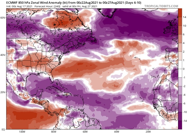
If you look at the EPS, after the suppressed Kelvin Wave, there's another CCKW right at the end of the month. So September 1-10 would be the window I would look for at this point. If that doesn't produce a long tracker or two, we're looking at an underachieving season.
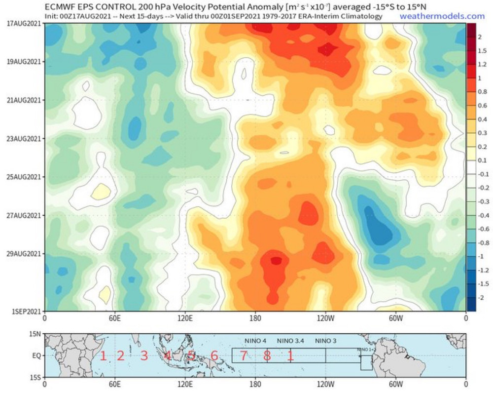
If you look at the EPS, after the suppressed Kelvin Wave, there's another CCKW right at the end of the month. So September 1-10 would be the window I would look for at this point. If that doesn't produce a long tracker or two, we're looking at an underachieving season.
2 likes
-
AlphaToOmega
- Category 5
- Posts: 1448
- Joined: Sat Jun 26, 2021 10:51 am
- Location: Somewhere in Massachusetts
Re: 2021 Indicators: SST's / SAL / MSLP / Shear / Steering / Instability / Sat Images
SFLcane wrote:Things are either gonna explode eventually or this will be a memorable September upcoming. One thing I can see now is the rest of August could be shut down with a big trade surge inbound.
https://i.postimg.cc/PxFGhtNM/5-EE8-CC92-1-D37-453-F-BE69-22-B22-FDE99-AB.jpg
If you look at the EPS, after the suppressed Kelvin Wave, there's another CCKW right at the end of the month. So September 1-10 would be the window I would look for at this point. If that doesn't produce a long tracker or two, we're looking at an underachieving season.
https://i.postimg.cc/zfQZYzyF/F516-B099-FC32-467-D-B9-E8-776-E12-FF0692.jpg
Trade winds in the MDR and the Gulf of Mexico are modeled to be below-average. The CCKW is modeled to be in the EPac from August 25 to August 30, which is a very short period of time. The rest of August is most likely not going to be shut down.
0 likes
-
SFLcane
- S2K Supporter
- Posts: 10281
- Age: 48
- Joined: Sat Jun 05, 2010 1:44 pm
- Location: Lake Worth Florida
Re: 2021 Indicators: SST's / SAL / MSLP / Shear / Steering / Instability / Sat Images
AlphaToOmega wrote:SFLcane wrote:Things are either gonna explode eventually or this will be a memorable September upcoming. One thing I can see now is the rest of August could be shut down with a big trade surge inbound.
https://i.postimg.cc/PxFGhtNM/5-EE8-CC92-1-D37-453-F-BE69-22-B22-FDE99-AB.jpg
If you look at the EPS, after the suppressed Kelvin Wave, there's another CCKW right at the end of the month. So September 1-10 would be the window I would look for at this point. If that doesn't produce a long tracker or two, we're looking at an underachieving season.
https://i.postimg.cc/zfQZYzyF/F516-B099-FC32-467-D-B9-E8-776-E12-FF0692.jpg
Trade winds in the MDR and the Gulf of Mexico are modeled to be below-average. The CCKW is modeled to be in the EPac from August 25 to August 30, which is a very short period of time. The rest of August is most likely not going to be shut down.
https://twitter.com/jasondunning/status/1427609769699856387
1 likes
Re: 2021 Indicators: SST's / SAL / MSLP / Shear / Steering / Instability / Sat Images
SFLcane wrote:Things are either gonna explode eventually or this will be a memorable September upcoming. One thing I can see now is the rest of August could be shut down with a big trade surge inbound.
https://i.postimg.cc/PxFGhtNM/5-EE8-CC92-1-D37-453-F-BE69-22-B22-FDE99-AB.jpg
If you look at the EPS, after the suppressed Kelvin Wave, there's another CCKW right at the end of the month. So September 1-10 would be the window I would look for at this point. If that doesn't produce a long tracker or two, we're looking at an underachieving season.
https://i.postimg.cc/zfQZYzyF/F516-B099-FC32-467-D-B9-E8-776-E12-FF0692.jpg
What do you mean a “big trade surge”? All of those are negative anomalies.
0 likes
Irene '11 Sandy '12 Hermine '16 5/15/2018 Derecho Fay '20 Isaias '20 Elsa '21 Henri '21 Ida '21
I am only a meteorology enthusiast who knows a decent amount about tropical cyclones. Look to the professional mets, the NHC, or your local weather office for the best information.
I am only a meteorology enthusiast who knows a decent amount about tropical cyclones. Look to the professional mets, the NHC, or your local weather office for the best information.
Who is online
Users browsing this forum: No registered users and 289 guests