Texas Spring-2015

U.S. & Caribbean Weather Discussions and Severe Weather Events

Moderator: S2k Moderators

Forum rules

The posts in this forum are NOT official forecast and should not be used as such. They are just the opinion of the poster and may or may not be backed by sound meteorological data. They are NOT endorsed by any professional institution or STORM2K.

Help Support Storm2K
Message
Author
User avatar
Rgv20
S2K Supporter
S2K Supporter
Posts: 2466
Age: 38
Joined: Wed Jan 05, 2011 5:42 pm
Location: Edinburg/McAllen Tx

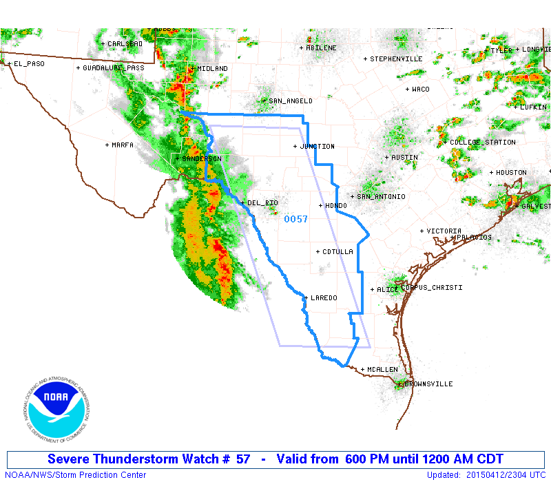
#261 Postby Rgv20 » Sun Apr 12, 2015 6:07 pm

Image

URGENT - IMMEDIATE BROADCAST REQUESTED
SEVERE THUNDERSTORM WATCH NUMBER 57
NWS STORM PREDICTION CENTER NORMAN OK
600 PM CDT SUN APR 12 2015

THE NWS STORM PREDICTION CENTER HAS ISSUED A

* SEVERE THUNDERSTORM WATCH FOR PORTIONS OF
CENTRAL AND SOUTH TEXAS

* EFFECTIVE THIS SUNDAY NIGHT FROM 600 PM UNTIL MIDNIGHT CDT.

* PRIMARY THREATS INCLUDE...
SCATTERED DAMAGING WIND GUSTS TO 70 MPH LIKELY
SCATTERED LARGE HAIL AND ISOLATED VERY LARGE HAIL EVENTS TO 2
INCHES IN DIAMETER POSSIBLE

THE SEVERE THUNDERSTORM WATCH AREA IS APPROXIMATELY ALONG AND 60
STATUTE MILES EAST AND WEST OF A LINE FROM 60 MILES WEST
NORTHWEST OF JUNCTION TEXAS TO 70 MILES SOUTH SOUTHEAST OF LAREDO
TEXAS. FOR A COMPLETE DEPICTION OF THE WATCH SEE THE ASSOCIATED
WATCH OUTLINE UPDATE (WOUS64 KWNS WOU7).

PRECAUTIONARY/PREPAREDNESS ACTIONS...

REMEMBER...A SEVERE THUNDERSTORM WATCH MEANS CONDITIONS ARE
FAVORABLE FOR SEVERE THUNDERSTORMS IN AND CLOSE TO THE WATCH
AREA. PERSONS IN THESE AREAS SHOULD BE ON THE LOOKOUT FOR
THREATENING WEATHER CONDITIONS AND LISTEN FOR LATER STATEMENTS
AND POSSIBLE WARNINGS. SEVERE THUNDERSTORMS CAN AND OCCASIONALLY
DO PRODUCE TORNADOES.

&&

OTHER WATCH INFORMATION...CONTINUE...WW 56...

DISCUSSION...A LARGE SQUALL LINE IS MOVING ACROSS NORTHERN MEXICO
AND WILL SPREAD ACROSS THE WATCH AREA THIS EVENING. STRENGTHENING
WINDS ALOFT WILL PROMOTE BOWING STORMS CAPABLE OF LOCALLY DAMAGING
WINDS AND HAIL.

AVIATION...A FEW SEVERE THUNDERSTORMS WITH HAIL SURFACE AND ALOFT
TO 2 INCHES. EXTREME TURBULENCE AND SURFACE WIND GUSTS TO 60
KNOTS. A FEW CUMULONIMBI WITH MAXIMUM TOPS TO 500. MEAN STORM
MOTION VECTOR 25035.


...HART
0 likes   
The following post is NOT an official forecast and should not be used as such. It is just the opinion of the poster and may or may not be backed by sound meteorological data. It is NOT endorsed by any professional institution including storm2k.org For Official Information please refer to the NHC and NWS products.

weatherdude1108
Category 5
Category 5
Posts: 4228
Joined: Tue Dec 13, 2011 1:04 pm
Location: Northwest Austin/Cedar Park, TX

#262 Postby weatherdude1108 » Sun Apr 12, 2015 7:50 pm

:uarrow:
I saw that. Pretty impressive, classic Mexico MCS. Mentions heavy rain in forecast where I am. In SA, mentions gusty winds and large hail. We'll see what happens. All we have had so far are sprinkles and fog this weekend.


AREA FORECAST DISCUSSION...UPDATED
NATIONAL WEATHER SERVICE AUSTIN/SAN ANTONIO TX
634 PM CDT SUN APR 12 2015

.AVIATION.../00Z TAFS/
MAIN CONCERN THIS FORECAST PERIOD WILL BE THE CONVECTION THAT WILL
LIKELY IMPACT ALL TERMINALS OVERNIGHT. LINE OS SHOWERS AND
THUNDERSTORMS CONTINUES TO PROGRESS EAST ACROSS NORTHERN MEXICO AT
THIS TIME. LOOKS TO ARRIVE IN KDRT BETWEEN 2330Z AND 01Z. FOR THE
I-35 CORRIDOR LOOKS LIKE AROUND 04Z-05Z FOR KSAT/KSSF AND 05Z-06Z
FOR KAUS. WILL CONTINUE TO SEE RAIN AND SHOWERS BEHIND THE LINE
FOR A FEW HOURS. WOULD EXPECT TO SEE AT LEAST PATCHY FOG
DEVELOPING 10Z-12Z AND CONTINUING THROUGH 15Z. WILL SEE MVFR CIGS
DEVELOP 03Z-05Z THEN DOWN TO IFR AFTER 07Z-09Z. AFTER 17Z-19Z ALL
SITES SHOULD RETURN TO VFR. WILL SEE SOUTHERLY WINDS 5 TO 10 KNOTS
TONIGHT AND AGAIN ON MONDAY. WINDS WILL BE VARIABLE AND GUSTY IN
OR NEAR ANY CONVECTION WITH GUSTS TO 50 KNOTS POSSIBLE.

.UPDATE...
UPDATED POPS TO REFLECT RADAR TRENDS WITH ONGOING MCS MOVING INTO
THE RIO GRANDE VALLEY THAT CURRENTLY HAS TWO BOWING SEGMENTS. THE
FIRST HAS CROSSED INTO VAL VERDE COUNTY AND HAS ALREADY BEEN
ASSOCIATED WITH A SEVERE WIND GUST IN TERRELL COUNTY TO THE WEST.
THE SECOND BOWING SEGMENT IS CURRENTLY LOCATED IN COAHUILA MEXICO
AND WILL ENTER MAVERICK COUNTY AROUND 00Z. SHEAR VALUES OF APPROX
40 KT AND CAPE VALUES AROUND 2500 J/KG ARE AHEAD OF THIS MORE
SOUTHERN BOWING SEGMENT...WHEREAS CAPE VALUES ARE HIGHER AROUND
3000 J/KG AND SHEAR VALUES ARE LOWER AROUND 30 KT WITH THE
NORTHERN BOWING SEGMENT. BASED ON THESE VALUES AND FORWARD
PROPAGATION SPEEDS OF 20-25 KT...EXPECT STRAIGHT LINE WIND DAMAGE
UP TO 70 MPH IN THE STRONGEST BOWING SEGMENTS WITH SEVERE WINDS UP
TO 60 MPH POSSIBLE IN OTHER NON- BOWING SEGMENTS OF THE GUST
FRONT. TORNADO THREAT AND SEVERE HAIL THREAT SHOULD BE LOW.

SEVERE THUNDERSTORM WATCH MAY BE EXTENDED FURTHER EAST BASED ON
ONGOING RADAR AND MODEL TRENDS. WILL UPDATE IF NEEDED.
0 likes   
The preceding post is NOT an official forecast, and should not be used as such. It is only the opinion of the poster and may or may not be backed by sound meteorological data. It is NOT endorsed by any professional institution including storm2k.org. For Official Information please refer to the NHC and NWS products.

User avatar
ravyrn
S2K Supporter
S2K Supporter
Posts: 1000
Age: 42
Joined: Sun Aug 31, 2008 5:10 am
Location: Alderbranch, TX

Re: Texas Spring-2015

#263 Postby ravyrn » Sun Apr 12, 2015 8:00 pm

My friend's kid in Nacogdoches was cooking at the stove this afternoon and got struck by lightning. He's in the hospital, but seems he will be okay. He just has severe pain in his arm and hand. Stay safe out there guys, even in doors!
0 likes   

User avatar
TheAustinMan
Category 5
Category 5
Posts: 1047
Age: 25
Joined: Mon Jul 08, 2013 4:26 pm
Location: United States
Contact:

#264 Postby TheAustinMan » Sun Apr 12, 2015 8:22 pm

San Antonio and the rest of South Texas are going to get a big smack from this system as it progresses eastward. I imagine there are going to be quite a few wind reports as the day goes on (there's already a few). Storms are weakening but still impressive.

Radar reflectivity (top) and velocity (bottom) visualized using McIDAS-V.
Image
0 likes   
ImageImageImage
Treat my opinions with a grain of salt. For official information see your local weather service.

User avatar
Rgv20
S2K Supporter
S2K Supporter
Posts: 2466
Age: 38
Joined: Wed Jan 05, 2011 5:42 pm
Location: Edinburg/McAllen Tx

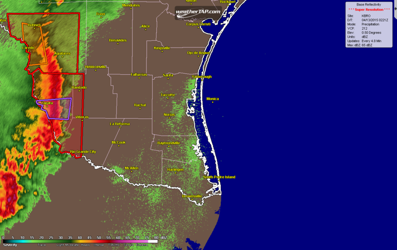
#265 Postby Rgv20 » Sun Apr 12, 2015 9:14 pm

Tornado Warning

TORNADO WARNING
TXC505-130230-
/O.NEW.KBRO.TO.W.0001.150413T0208Z-150413T0230Z/

BULLETIN - EAS ACTIVATION REQUESTED
TORNADO WARNING
NATIONAL WEATHER SERVICE BROWNSVILLE TX
908 PM CDT SUN APR 12 2015

THE NATIONAL WEATHER SERVICE IN BROWNSVILLE HAS ISSUED A

* TORNADO WARNING FOR...
CENTRAL ZAPATA COUNTY IN DEEP SOUTH TEXAS...


* UNTIL 930 PM CDT

* AT 907 PM CDT...DOPPLER RADAR INDICATED A SEVERE THUNDERSTORM
CAPABLE OF PRODUCING A TORNADO. THIS DANGEROUS STORM WAS LOCATED
OVER FALCON MESA...OR NEAR ZAPATA...AND MOVING EAST AT 50 MPH.

IN ADDITION TO THE THREAT OF A TORNADO STRAIGHT LINE WIND GUSTS OF
UP TO 90 MPH WILL BE POSSIBLE WITH THIS STORM. TAKE IMMEDIATE
SHELTER!


* LOCATIONS IMPACTED INCLUDE...
ZAPATA...ZAPATA COUNTY AIRPORT...MEDINA...ZAPATA MIDDLE SCHOOL...
MORALES-SANCHEZ...LAS PALMAS...ZAPATA HIGH SCHOOL...ZAPATA COUNTY
PUBLIC LIBRARY...FALCON LAKE ESTATES...ZAPATA COUNTY FIRE
DEPARTMENT...FALCON SHORES...FALCON MESA...SIESTA SHORES...
ZAPATA--MEDINA...BLACK BASS AND ROMEO T. FLORES PARK.

PRECAUTIONARY/PREPAREDNESS ACTIONS...

TAKE COVER NOW. MOVE TO A BASEMENT OR AN INTERIOR ROOM ON THE LOWEST
FLOOR OF A STURDY BUILDING. AVOID WINDOWS. IF YOU ARE IN A MOBILE
HOME OR OUTDOORS...MOVE TO THE CLOSEST SUBSTANTIAL SHELTER AND
PROTECT YOURSELF FROM FLYING DEBRIS.

HEAVY RAINFALL MAY OBSCURE THIS TORNADO. DO NOT WAIT TO SEE OR HEAR
THE TORNADO. TAKE COVER NOW.

&&

LAT...LON 2697 9938 2700 9897 2677 9900 2678 9924
2686 9928 2686 9929 2687 9932 2688 9933
2692 9932 2693 9938 2695 9939 2697 9939
TIME...MOT...LOC 0207Z 276DEG 45KT 2687 9932

$$

JGG
0 likes   
The following post is NOT an official forecast and should not be used as such. It is just the opinion of the poster and may or may not be backed by sound meteorological data. It is NOT endorsed by any professional institution including storm2k.org For Official Information please refer to the NHC and NWS products.

User avatar
Rgv20
S2K Supporter
S2K Supporter
Posts: 2466
Age: 38
Joined: Wed Jan 05, 2011 5:42 pm
Location: Edinburg/McAllen Tx

#266 Postby Rgv20 » Sun Apr 12, 2015 9:22 pm

Image

SEVERE WEATHER STATEMENT
NATIONAL WEATHER SERVICE BROWNSVILLE TX
914 PM CDT SUN APR 12 2015

TXC247-427-505-130230-
/O.CON.KBRO.SV.W.0007.000000T0000Z-150413T0230Z/
JIM HOGG TX-ZAPATA TX-STARR TX-
914 PM CDT SUN APR 12 2015

...A SEVERE THUNDERSTORM WARNING REMAINS IN EFFECT UNTIL 930 PM CDT
FOR WESTERN JIM HOGG...ZAPATA AND WESTERN STARR COUNTIES...

AT 912 PM CDT...DOPPLER RADAR INDICATED A LINE OF SEVERE
THUNDERSTORMS CAPABLE OF PRODUCING QUARTER SIZE HAIL AND DESTRUCTIVE
WINDS IN EXCESS OF 80 MPH. THESE STORMS WERE LOCATED ALONG A LINE
EXTENDING FROM 16 MILES SOUTHEAST OF LA PRESA TO FALCON LAKE ESTATES
TO 13 MILES SOUTHWEST OF FALCON DAM...MOVING EAST AT 55 MPH.

LOCATIONS IMPACTED INCLUDE...
ZAPATA...ROMA...BUSTAMANTE...EL SAUZ...LA ROSITA...ROMA CITY HALL...
ROMA HIGH SCHOOL...ZAPATA COUNTY AIRPORT...ROMA PUBLIC LIBRARY...
MEDINA...ESCOBARES...FALCON DAM...LOPENO...NORTH ESCOBARES...LOS
ALVAREZ...LAS PALMAS...ZAPATA COUNTY PUBLIC LIBRARY...ZAPATA COUNTY
FIRE DEPARTMENT AND RANDADO.

PRECAUTIONARY/PREPAREDNESS ACTIONS...

TO REPORT SEVERE WEATHER...CONTACT YOUR NEAREST LAW ENFORCEMENT
AGENCY. THEY WILL RELAY YOUR REPORT TO THE NATIONAL WEATHER SERVICE
OFFICE IN BROWNSVILLE .

THIS IS AN EXTREMELY DANGEROUS SITUATION WITH TORNADO LIKE WIND
SPEEDS EXPECTED. MOBILE HOMES AND HIGH PROFILE VEHICLES ARE
ESPECIALLY SUSCEPTIBLE TO WINDS OF THIS MAGNITUDE AND MAY BE
OVERTURNED. FOR YOUR PROTECTION MOVE IMMEDIATELY TO A SAFE SHELTER OR
TO AN INTERIOR ROOM ON THE LOWEST FLOOR OF YOUR HOME OR BUSINESS.
THESE STORMS HAVE THE POTENTIAL TO CAUSE SERIOUS INJURY AND
SIGNIFICANT PROPERTY DAMAGE.


&&

LAT...LON 2718 9943 2727 9945 2732 9937 2727 9932
2727 9882 2636 9884 2635 9890 2639 9893
2637 9895 2640 9896 2641 9903 2640 9908
2643 9911 2648 9909 2654 9917 2672 9921
2684 9927 2694 9939 2698 9938 2702 9945
TIME...MOT...LOC 0212Z 268DEG 47KT 2725 9924 2687 9925 2647 9935

$$

SPEECE
0 likes   
The following post is NOT an official forecast and should not be used as such. It is just the opinion of the poster and may or may not be backed by sound meteorological data. It is NOT endorsed by any professional institution including storm2k.org For Official Information please refer to the NHC and NWS products.

User avatar
ravyrn
S2K Supporter
S2K Supporter
Posts: 1000
Age: 42
Joined: Sun Aug 31, 2008 5:10 am
Location: Alderbranch, TX

Re: Texas Spring-2015

#267 Postby ravyrn » Sun Apr 12, 2015 11:00 pm

Image
Supercell pic from Lubbock, TX from this evening

Credit goes to /u/redradier81 on reddit.
0 likes   

User avatar
TeamPlayersBlue
Category 5
Category 5
Posts: 3445
Joined: Tue Feb 02, 2010 1:44 am
Location: Denver/Applewood, CO

#268 Postby TeamPlayersBlue » Sun Apr 12, 2015 11:05 pm

Woah. Just saw the squall line. Very serious situation, you all stay safe.
0 likes   
Personal Forecast Disclaimer:
The posts in this forum are NOT official forecast and should not be used as such. They are just the opinion of the poster and may or may not be backed by sound meteorological data. They are NOT endorsed by any professional institution or storm2k.org. For official information, please refer to the NHC and NWS products.

weatherdude1108
Category 5
Category 5
Posts: 4228
Joined: Tue Dec 13, 2011 1:04 pm
Location: Northwest Austin/Cedar Park, TX

#269 Postby weatherdude1108 » Sun Apr 12, 2015 11:42 pm

And there you have it. I guess I will be turning my sprinklers on. My life story. :roll:


AREA FORECAST DISCUSSION
NATIONAL WEATHER SERVICE AUSTIN/SAN ANTONIO TX
1106 PM CDT SUN APR 12 2015

.UPDATE...
GRIDS AND ZONES HAVE BEEN UPDATED TO CANCEL SEVERE THUNDERSTORM
WATCH #57. CAPPING EVIDENT ON 00Z DRT SOUNDING AT 4-5 KFT AND SPC
MESOANALYSES LIKELY PREVENTED SEVERE WINDS FROM MIXING DOWN TO THE
SURFACE EARLIER THIS EVENING...AND THIS CONVECTIVE INHIBITION
CONTINUES TO SPREAD OUT IN FRONT OF THE ONGOING LINE OF STORMS.
STRONGER SHEAR VALUES HAVE ALSO REMAINED SOUTH OF OUR CWA. ALTHOUGH
A FEW SPOTS OF LOCALLY HEAVY RAINFALL WILL BE POSSIBLE WHERE
CONVECTIVE ELEMENTS BRIEFLY TRAIN IN FRONT OF THE MAIN CONVECTIVE
LINE...HIRES MODELS SUGGEST THIS LINE WILL GRADUALLY WEAKEN AND
COVERAGE WILL BECOME LESS WIDESPREAD AS IT MOVES NORTHEAST. GRIDS
HAVE BEEN UPDATED TO REFLECT THESE TRENDS AS THE ATMOSPHERE SHOULD
STABILIZE FOR THE REST OF THE EVENING BEHIND THIS LINE.
0 likes   
The preceding post is NOT an official forecast, and should not be used as such. It is only the opinion of the poster and may or may not be backed by sound meteorological data. It is NOT endorsed by any professional institution including storm2k.org. For Official Information please refer to the NHC and NWS products.

BigB0882
S2K Supporter
S2K Supporter
Posts: 2284
Joined: Thu Jul 03, 2003 12:08 am
Location: Baton Rouge, LA
Contact:

Re: Texas Spring-2015

#270 Postby BigB0882 » Sun Apr 12, 2015 11:47 pm

ravyrn wrote:Image
Supercell pic from Lubbock, TX from this evening

Credit goes to /u/redradier81 on reddit.


That is incredible. I thought it was a photoshopped picture of a nuclear bomb going off.
0 likes   

Brent
S2K Supporter
S2K Supporter
Posts: 38088
Age: 36
Joined: Sun May 16, 2004 10:30 pm
Location: Tulsa Oklahoma
Contact:

Re: Texas Spring-2015

#271 Postby Brent » Mon Apr 13, 2015 12:14 am

Popcorn storms firing over DFW now... lots of lightning just started around Fort Worth and Grand Prairie
0 likes   
#neversummer

weatherdude1108
Category 5
Category 5
Posts: 4228
Joined: Tue Dec 13, 2011 1:04 pm
Location: Northwest Austin/Cedar Park, TX

Re: Texas Spring-2015

#272 Postby weatherdude1108 » Mon Apr 13, 2015 8:29 am

BigB0882 wrote:
ravyrn wrote:Image
Supercell pic from Lubbock, TX from this evening

Credit goes to /u/redradier81 on reddit.


That is incredible. I thought it was a photoshopped picture of a nuclear bomb going off.


That is awesome! Someone posted the time lapse version of it on FB. The cumulonimbus forming an anvil of mammatus, with the sun reflecting off of it looked like an explosion. Amazing!
0 likes   

User avatar
Portastorm
Storm2k Moderator
Storm2k Moderator
Posts: 9914
Age: 63
Joined: Fri Jul 11, 2003 9:16 am
Location: Round Rock, TX
Contact:

Re:

#273 Postby Portastorm » Mon Apr 13, 2015 8:47 am

weatherdude1108 wrote:And there you have it. I guess I will be turning my sprinklers on. My life story. :roll:


AREA FORECAST DISCUSSION
NATIONAL WEATHER SERVICE AUSTIN/SAN ANTONIO TX
1106 PM CDT SUN APR 12 2015

.UPDATE...
GRIDS AND ZONES HAVE BEEN UPDATED TO CANCEL SEVERE THUNDERSTORM
WATCH #57. CAPPING EVIDENT ON 00Z DRT SOUNDING AT 4-5 KFT AND SPC
MESOANALYSES LIKELY PREVENTED SEVERE WINDS FROM MIXING DOWN TO THE
SURFACE EARLIER THIS EVENING...AND THIS CONVECTIVE INHIBITION
CONTINUES TO SPREAD OUT IN FRONT OF THE ONGOING LINE OF STORMS.
STRONGER SHEAR VALUES HAVE ALSO REMAINED SOUTH OF OUR CWA. ALTHOUGH
A FEW SPOTS OF LOCALLY HEAVY RAINFALL WILL BE POSSIBLE WHERE
CONVECTIVE ELEMENTS BRIEFLY TRAIN IN FRONT OF THE MAIN CONVECTIVE
LINE...HIRES MODELS SUGGEST THIS LINE WILL GRADUALLY WEAKEN AND
COVERAGE WILL BECOME LESS WIDESPREAD AS IT MOVES NORTHEAST. GRIDS
HAVE BEEN UPDATED TO REFLECT THESE TRENDS AS THE ATMOSPHERE SHOULD
STABILIZE FOR THE REST OF THE EVENING BEHIND THIS LINE.


Kinda a sad joke isn't it?! Austin has been stiffed multiple times in the last few weeks. I've lost track of how many ghost shortwaves were predicted along with attendant rain and they never happened. And then last night's "mighty" squall line which amounted to a tenth of an inch of rain. ha ha. Bring on the drought. :roll:
0 likes   
Any forecasts under my name are to be taken with a grain of salt. Get your best forecasts from the National Weather Service and National Hurricane Center.

User avatar
Rgv20
S2K Supporter
S2K Supporter
Posts: 2466
Age: 38
Joined: Wed Jan 05, 2011 5:42 pm
Location: Edinburg/McAllen Tx

#274 Postby Rgv20 » Mon Apr 13, 2015 9:17 am

Damn last night was rough in my backyard! Lost power for about 2 hours and had a lot of wind&thunder!
0 likes   
The following post is NOT an official forecast and should not be used as such. It is just the opinion of the poster and may or may not be backed by sound meteorological data. It is NOT endorsed by any professional institution including storm2k.org For Official Information please refer to the NHC and NWS products.

User avatar
Ntxw
Storm2k Moderator
Storm2k Moderator
Posts: 22784
Joined: Wed Oct 21, 2009 6:34 pm
Location: DFW, Texas

#275 Postby Ntxw » Mon Apr 13, 2015 10:00 am

Deluge going on in northern Tarrant and Dallas counties, watch out for flash flooding
0 likes   
The above post and any post by Ntxw is NOT an official forecast and should not be used as such. It is just the opinion of the poster and may or may not be backed by sound meteorological data. It is NOT endorsed by any professional institution including Storm2k. For official information, please refer to NWS products.

  Help support Storm2K!
Help Support Storm2K

BrokenGlassRepublicn
Category 1
Category 1
Posts: 481
Joined: Sun Nov 20, 2011 8:07 pm
Location: Richardson, Texas

Re:

#276 Postby BrokenGlassRepublicn » Mon Apr 13, 2015 10:36 am

Ntxw wrote:Deluge going on in northern Tarrant and Dallas counties, watch out for flash flooding

We're going to fill up Lavon today!!
0 likes   

TarrantWx
Category 1
Category 1
Posts: 287
Age: 39
Joined: Thu Jan 30, 2014 10:38 am
Location: Keller, TX

#277 Postby TarrantWx » Mon Apr 13, 2015 10:47 am

From NWS Ft Worth:

NWS Fort Worth @NWSFortWorth · 31m 31 minutes ago
Early yet, but this may turn into one of the better precipitation events for the Eagle Mtn Lake/Lake Grapevine basins in a while.
0 likes   

Brent
S2K Supporter
S2K Supporter
Posts: 38088
Age: 36
Joined: Sun May 16, 2004 10:30 pm
Location: Tulsa Oklahoma
Contact:

Re: Texas Spring-2015

#278 Postby Brent » Mon Apr 13, 2015 11:20 am

Out my back door :eek:

Image
0 likes   
#neversummer

JayDT
Category 1
Category 1
Posts: 354
Joined: Tue Dec 16, 2014 12:55 pm
Location: Dallas, Texas

#279 Postby JayDT » Mon Apr 13, 2015 11:54 am

Just got some very heavy rain around Duncanville. :ggreen: :D
0 likes   

User avatar
TeamPlayersBlue
Category 5
Category 5
Posts: 3445
Joined: Tue Feb 02, 2010 1:44 am
Location: Denver/Applewood, CO

#280 Postby TeamPlayersBlue » Mon Apr 13, 2015 12:10 pm

There ya go! Keep on dumping.
0 likes   
Personal Forecast Disclaimer:
The posts in this forum are NOT official forecast and should not be used as such. They are just the opinion of the poster and may or may not be backed by sound meteorological data. They are NOT endorsed by any professional institution or storm2k.org. For official information, please refer to the NHC and NWS products.


Return to “USA & Caribbean Weather”

Who is online

Users browsing this forum: No registered users and 10 guests