Teban54 wrote:Note that there's a satellite data outage now: Most sources that I know only have GOES imagery as of 16:30z (12:30 pm EDT, almost 2 hours ago), not later.
Outage is now over and images are updating.

Moderator: S2k Moderators


Teban54 wrote:Note that there's a satellite data outage now: Most sources that I know only have GOES imagery as of 16:30z (12:30 pm EDT, almost 2 hours ago), not later.


MEANINGLESS_NUMBERS wrote:There is a commonly held belief in Bermuda that the waters here could not support a category 5, and perhaps not even a category 4. Seeing this swirl just offshore has been eye opening.
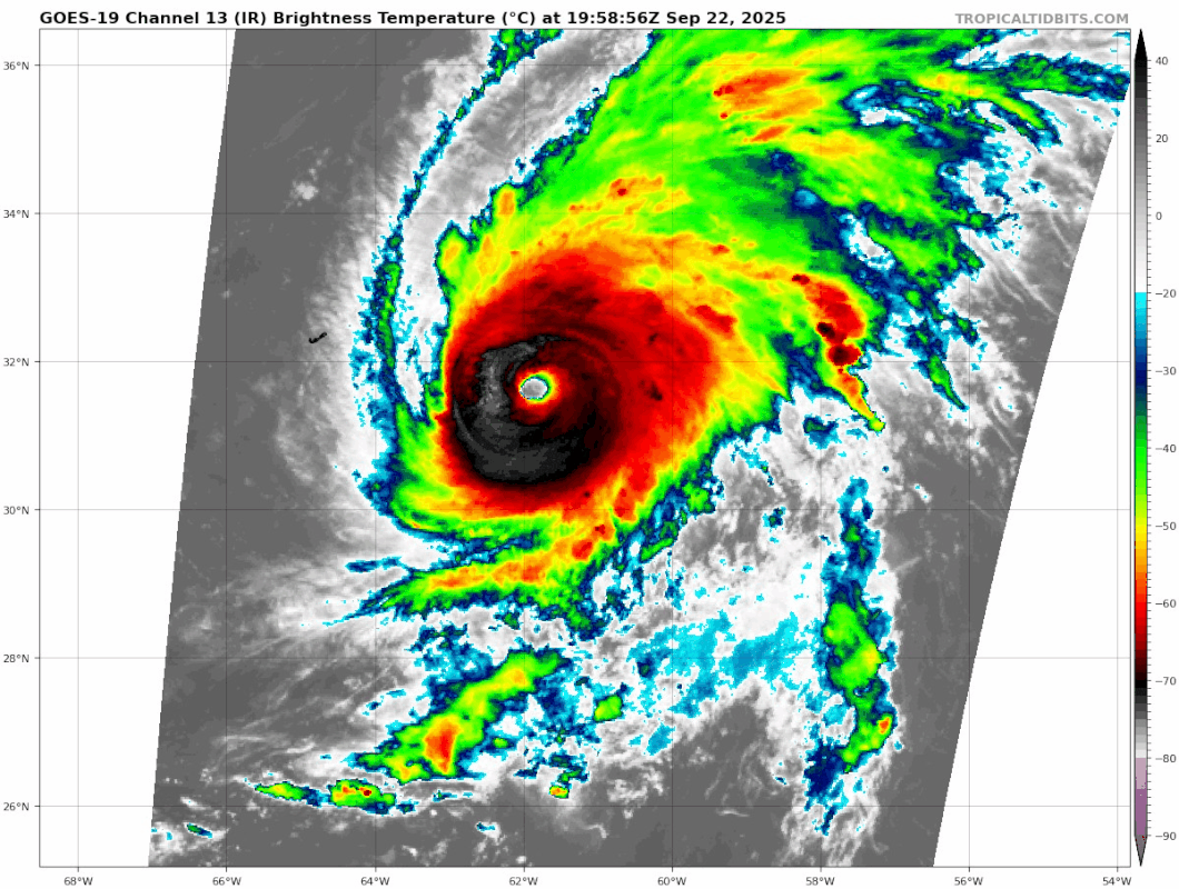
CrazyC83 wrote:A bit surprised they went that high since the data was borderline, although a T6.0 Dvorak rating can tilt things towards the higher end. 124 kt FL = 112 kt at the surface (and 129 kt at 750 mb = about 111 kt), so it's right in the middle.
2025 is starting to remind me of either a more active 2014 or 2007. Feast or famine.


CrazyC83 wrote:As the ADT has improved more (to T6.1 - T6.5 Raw), I'd go up to 120 kt at the advisory.
StormWeather wrote:CrazyC83 wrote:As the ADT has improved more (to T6.1 - T6.5 Raw), I'd go up to 120 kt at the advisory.
I’m torn between thinking it’s 115 kts right now, and maybe it being 120 kts.
I think the NHC will go 115 kts, 950 mb for the upcoming update.
Beef Stew wrote:Gabrielle is shaping up to be one of those rare, beautiful mid-latitude monsters. And to think this storm was struggling immensely just a few days ago too.
Travorum wrote:120kts at the advisory
Hurricane Gabrielle Advisory Number 24
NWS National Hurricane Center Miami FL AL072025
500 PM AST Mon Sep 22 2025
...GABRIELLE NOW A CATEGORY 4 HURRICANE...
...INTERESTS IN THE AZORES SHOULD MONITOR...
SUMMARY OF 500 PM AST...2100 UTC...INFORMATION
----------------------------------------------
LOCATION...31.7N 61.8W
ABOUT 180 MI...290 KM ESE OF BERMUDA
ABOUT 2005 MI...3230 KM W OF THE AZORES
MAXIMUM SUSTAINED WINDS...140 MPH...220 KM/H
PRESENT MOVEMENT...NNE OR 20 DEGREES AT 12 MPH...19 KM/H
MINIMUM CENTRAL PRESSURE...948 MB...28.00 INCHES
INIT 22/2100Z 31.7N 61.8W 120 KT 140 MPH


StormWeather wrote:I wouldn’t be surprised to see this make a run for 130 kts or higher.
What’s the highest latitude that a storm has reached Category 5 in this basin?
StormWeather wrote:I wouldn’t be surprised to see this make a run for 130 kts or higher.
What’s the highest latitude that a storm has reached Category 5 in this basin?

Users browsing this forum: No registered users and 89 guests


