Winter Weather Discussion
Moderator: S2k Moderators
Forum rules
 The posts in this forum are NOT official forecast and should not be used as such.
 They are just the opinion of the poster and may or may not be backed by sound meteorological data. They are NOT endorsed by any professional institution or
STORM2K.
-
TomballEd
- Category 5

- Posts: 1178
- Age: 62
- Joined: Wed Aug 16, 2023 4:52 pm
- Location: Spring/Klein area, not Tomball
#2621 Postby TomballEd » Mon Jan 19, 2026 4:26 pm
Snowman67 wrote:I live on the Harris County/Montgomery County line in far Northwest Tomball. Are the models currently showing freezing rain here with this storm, or mainly just rain?
We live in an interesting place. I don't know how to change my forum name but I'm in Spring now, not Tomball. But same boat.
The freezing line probably gets here as the precip is ending. Any amount of FZRA is an issue on mountains and overpasses but major bridges will be treated. The question is does the change to FZRA happen early enough to maybe damage trees/down powerlines. I'm leaning no personally but a Saturday forecast on a Monday might not be the same forecast on a Thursday or Friday.
0 likes
-
TomballEd
- Category 5
- Posts: 1178
- Age: 62
- Joined: Wed Aug 16, 2023 4:52 pm
- Location: Spring/Klein area, not Tomball
#2622 Postby TomballEd » Mon Jan 19, 2026 4:29 pm
Quixotic wrote:HockeyTx82 wrote:Gotwood wrote:The position of the HP looks better as well for us correct?
When you say looks better, do you mean not crushing the infrastructure and causing widespread chaos, or hell yeah we're going to get obliterated and shut down everything! I think our definition of better on this website sometimes escapes us.
I'm not saying anyone's condoning destruction, but at the same time I'm just curious what better means.

That’s the thing about the rolling blackouts. I didn’t sleep because my cpap kept shutting off. Couldn’t sleep worth a hoot.
I did almost everything else right. Marked the water shut off switch in 8” of snow. Had a cord of wood. Kept the pipes warm by opening the door to the attic. The only other thing I didn’t do right was drain the sprinkler system but even that there was only two breaks. One on my side and the joint before the shutoff valve. Cost $600 to fix it. Lost all my boxwoods and Indian hawthorns in the front yard. Even lost the youpon holly. lol. I didn’t think that was possible.
I sleep horribly w/o CPAP. I've been meaning to buy a rechargeable or solar powered CPAP battery since Beryl but haven't done so. I hope ERCOT drops the AI and Datamining plants to keep the rest of the state lit if load gets too high. But I suspect they'll be a stripe from SC to E Texas with enough ice to cause large power outages.
0 likes
-
wxman57
- Moderator-Pro Met

- Posts: 23163
- Age: 68
- Joined: Sat Jun 21, 2003 8:06 pm
- Location: Houston, TX (southwest)
#2623 Postby wxman57 » Mon Jan 19, 2026 4:30 pm
WacoWx wrote:Hate to jinx it, but TWC app now has Dallas getting 3-5" of ice/snow on Saturday.
That appears to match the GFS model output. I don't think any meteorologist at TWC oversees the forecast.
1 likes
-
wxman57
- Moderator-Pro Met
- Posts: 23163
- Age: 68
- Joined: Sat Jun 21, 2003 8:06 pm
- Location: Houston, TX (southwest)
#2624 Postby wxman57 » Mon Jan 19, 2026 4:37 pm
18Z NBM (based on 12Z data) has temps 33-35 Sat/Sun with a low of 31 on Monday here in Houston. Sometimes a blend of models is not the best solution. I'm not sure what models are in this blend. The NBM website mentions use of the EC, CMC, and GFS operational and various ensembles.
0 likes
-
TomballEd
- Category 5
- Posts: 1178
- Age: 62
- Joined: Wed Aug 16, 2023 4:52 pm
- Location: Spring/Klein area, not Tomball
#2625 Postby TomballEd » Mon Jan 19, 2026 4:38 pm
wxman57 wrote:WacoWx wrote:Hate to jinx it, but TWC app now has Dallas getting 3-5" of ice/snow on Saturday.
That appears to match the GFS model output. I don't think any meteorologist at TWC oversees the forecast.
No idea about the app but I do know TWC uses older former TV hosts to do local segments on the radio and I'd at least hope they would at least try to do more rip and reads even if they cover well separated forecast areas. I do know people complain about NOAA/NWS but I trust a team of specialists in the national forecast centers and people who just do the HGX CWA more than I trust any TWC forecast or ABC 13 Accuweather forecast.
1 likes
-
TomballEd
- Category 5
- Posts: 1178
- Age: 62
- Joined: Wed Aug 16, 2023 4:52 pm
- Location: Spring/Klein area, not Tomball
#2626 Postby TomballEd » Mon Jan 19, 2026 4:40 pm
wxman57 wrote:18Z NBM (based on 12Z data) has temps 33-35 Sat/Sun with a low of 31 on Monday here in Houston. Sometimes a blend of models is not the best solution. I'm not sure what models are in this blend. The NBM website mentions use of the EC, CMC, and GFS operational and various ensembles.
There isn't something like the Super Secret FSU super ensemble NHC used to reference all the time that apparently weighted various models for known biases for mid-latitude forecasting?
0 likes
-
Ntxw
- Storm2k Moderator

- Posts: 23320
- Joined: Wed Oct 21, 2009 6:34 pm
- Location: DFW, Texas
#2627 Postby Ntxw » Mon Jan 19, 2026 4:40 pm
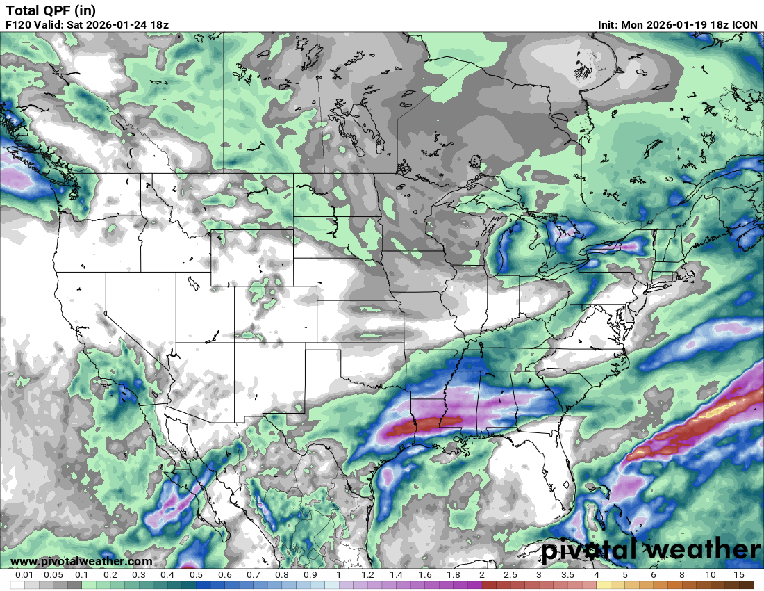
FWIW 18z ICON ticked up again in QPF. It doesn't depict snow but rather qpf falling at or below freezing in N and NE Texas.
3 likes
The above post and any post by Ntxw is NOT an official forecast and should not be used as such. It is just the opinion of the poster and may or may not be backed by sound meteorological data. It is NOT endorsed by any professional institution including Storm2k. For official information, please refer to NWS products.
Help support Storm2K!

-
Kingarabian
- S2K Supporter

- Posts: 16318
- Joined: Sat Aug 08, 2009 3:06 am
- Location: Honolulu, Hawaii
#2628 Postby Kingarabian » Mon Jan 19, 2026 4:41 pm
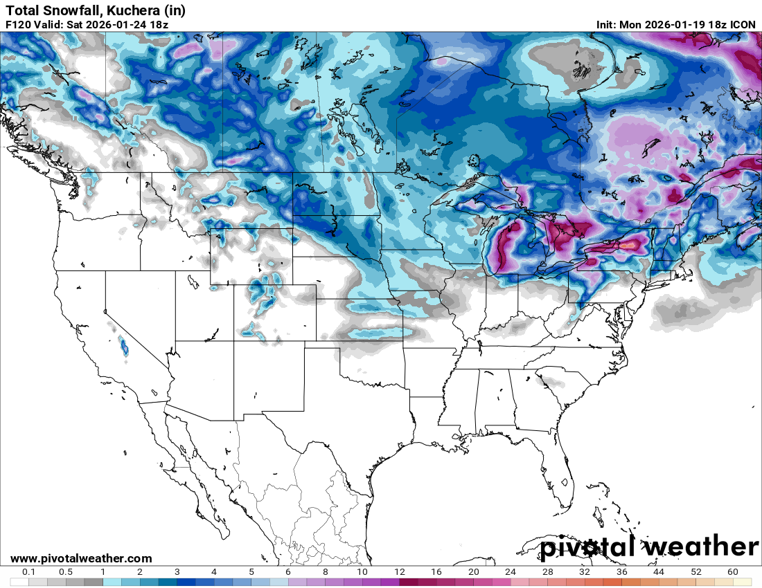
ICON playing spoiler in regards to snow?
Last edited by
Kingarabian on Mon Jan 19, 2026 4:48 pm, edited 1 time in total.
0 likes
RIP Kobe Bryant
-
Gotwood
- Category 2

- Posts: 708
- Joined: Wed Dec 14, 2022 7:18 pm
- Location: Brock Tx
#2629 Postby Gotwood » Mon Jan 19, 2026 4:44 pm
Kingarabian wrote:ICON playing spoiler in regards to snow?
The Icon has done well with arctic air masses but it isn’t coming around yet.
1 likes
-
ThunderSleetDreams
- S2K Supporter
- Posts: 1503
- Age: 43
- Joined: Tue Dec 20, 2011 4:42 pm
- Location: S of Weimar, TX
#2630 Postby ThunderSleetDreams » Mon Jan 19, 2026 4:45 pm
Kingarabian wrote:ICON playing spoiler in regards to snow?
No, the ICON doesn’t tell you what the precip type is just that precip is falling.
1 likes
#NeverSummer
I hibernate when it gets above 75 degrees!
-
rwfromkansas
- Category 5
- Posts: 2885
- Joined: Sat Aug 27, 2005 12:47 am
- Location: North Fort Worth
#2631 Postby rwfromkansas » Mon Jan 19, 2026 4:47 pm
Kingarabian wrote:ICON playing spoiler in regards to snow?
I think they mean the model doesn't really try to differentiate between types of frozen.
1 likes
-
Kingarabian
- S2K Supporter
- Posts: 16318
- Joined: Sat Aug 08, 2009 3:06 am
- Location: Honolulu, Hawaii
#2632 Postby Kingarabian » Mon Jan 19, 2026 4:49 pm
ThunderSleetDreams wrote:Kingarabian wrote:ICON playing spoiler in regards to snow?
No, the ICON doesn’t tell you what the precip type is just that precip is falling.
Ah understood. I just thought otherwise because Pivotal has snowfall enabled.
0 likes
RIP Kobe Bryant
-
snownado
- Category 5
- Posts: 1023
- Joined: Sat Dec 09, 2023 7:00 pm
- Location: Plano, TX
#2633 Postby snownado » Mon Jan 19, 2026 4:50 pm
ThunderSleetDreams wrote:Kingarabian wrote:ICON playing spoiler in regards to snow?
No, the ICON doesn’t tell you what the precip type is just that precip is falling.
Pivotal Weather has the same precip type maps for the ICON as the EURO/GFS/GGEM...
0 likes
-
orangeblood
- S2K Supporter
- Posts: 3827
- Joined: Tue Dec 15, 2009 6:14 pm
- Location: Fort Worth, TX
#2634 Postby orangeblood » Mon Jan 19, 2026 4:54 pm
ICON is the outlier by far and is playing catch up to the others, it’ll come around. Usually see the same trend happen with the NAM at the early stages of its cycle
2 likes
-
txtwister78
- Category 5
- Posts: 2061
- Joined: Wed Jan 30, 2019 12:56 pm
- Location: San Antonio
#2636 Postby txtwister78 » Mon Jan 19, 2026 5:02 pm
18z gfs definitely coming in warmer regarding surface temps compared to the 12z run
1 likes
-
HockeyTx82
- S2K Supporter
- Posts: 2717
- Joined: Tue Oct 27, 2009 11:17 am
- Location: Ponder, TX
#2637 Postby HockeyTx82 » Mon Jan 19, 2026 5:13 pm
txtwister78 wrote:18z gfs definitely coming in warmer regarding surface temps compared to the 12z run
And
Here
We
Go.......
2 likes
Don't hold me accountable for anything I post on this forum. Leave the real forecasting up to the professionals.
Location: Ponder, TX (all observation posts are this location unless otherwise noted)
-
wxman22
- Category 5
- Posts: 1780
- Joined: Mon Jan 30, 2006 12:39 am
- Location: Wichita Falls, TX
-
Contact:
#2638 Postby wxman22 » Mon Jan 19, 2026 5:14 pm
1 likes
-
Stratton23
- Category 5
- Posts: 3373
- Joined: Fri Jul 21, 2023 10:59 pm
- Location: Katy, Tx
#2639 Postby Stratton23 » Mon Jan 19, 2026 5:15 pm
GFS likely too warm with surface temps again
2 likes
-
Harp.1
- Category 1

- Posts: 304
- Joined: Tue Dec 12, 2023 12:37 am
#2640 Postby Harp.1 » Mon Jan 19, 2026 5:15 pm
It moves everything to the east quicker
1 likes
Return to “Winter Weather”
Who is online
Users browsing this forum: A1A, Brazoria979cnty, bubba hotep, CaptinCrunch, Captmorg70, Cdenton12, cheezyWXguy, chickypez, Coldandsnow, Cpv17, dhweather, downsouthman1, Gotwood, Harp.1, HockeyTx82, Iceresistance, jg5894, LearnedHat, ludosc, Ntxw, Portastorm, Quixotic, Ralph's Weather, rwfromkansas, Sambucol2024, South Texas Storms, Stratton23, Tammie, techfan012, Texas Snow, Texas Snowman, texsn95, ThunderSleetDreams, WacoWx, WeatherP1, wildbill, wxman22 and 495 guests