rwfromkansas wrote:they should have stayed until landfall.
Easy there, hotshot. Those g-force limits are for their safety.
Moderator: S2k Moderators

rwfromkansas wrote:they should have stayed until landfall.
tallywx wrote:Ed_2001 wrote:Nimbus wrote:
38 with 58 at the airport now
28 05:00 E 38 G 54 0.00 Heavy Rain and Windy BKN010 OVC045 77 75.2 94% 78 0 0.0
Then that anemometer is collecting faulty or outdated data. I mean just check out the video tweet to your top.
Timestamp 05:00 local? That was 9 hours ago!


GCANE wrote:Got to hand it to Lockheed.
They build planes that take a beating and keep on ticking.

Hurrilurker wrote:It's a mess (and disaster) but honestly it could have been a lot worse. If it was going to hit Jamaica, that looks like about the best possible path it could have taken for minimal population impacts.
TomballEd wrote:GCANE wrote:Got to hand it to Lockheed.
They build planes that take a beating and keep on ticking.
They get overhauled every few years and are out of service for the better part of a year (I saw something on Discovery) but the planes are 50 years old. The Navy is phasing out the last of the Orion subhunters in favor the P8 Poseidon (both the Orion and Poseidon are modified civilian aircraft, the Lockheed Electra and the B-737)). NOAA is going to have to start training its own Orion pilots with the Navy retiring the plane.
The WC-130J just looks sturdier to me.
dukeblue219 wrote:Hurrilurker wrote:It's a mess (and disaster) but honestly it could have been a lot worse. If it was going to hit Jamaica, that looks like about the best possible path it could have taken for minimal population impacts.
It's really hard to tell the day-of, though. Katrina felt the same way - "it's weakening," "it missed New Orleans to the East," "the levees appear to be holding," etc.

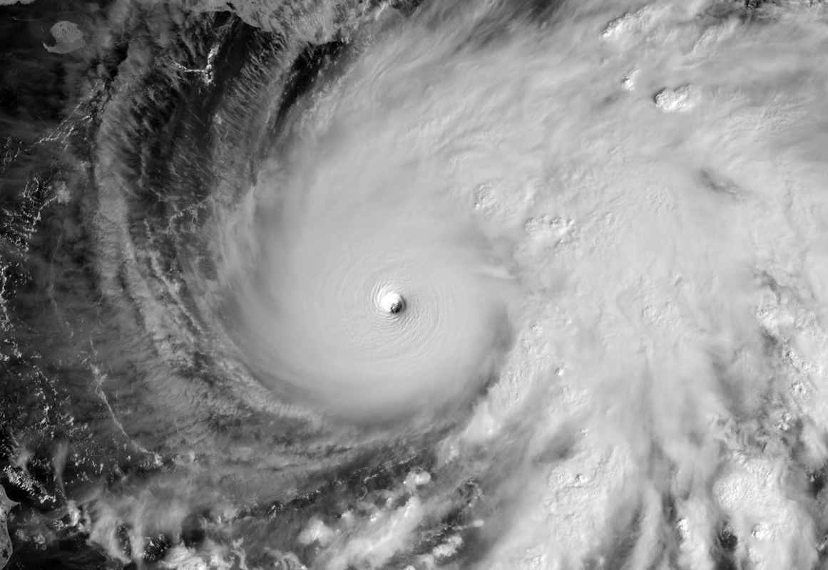


Teban54 wrote:NOAA is back into Melissa and has an extrap pressure of 952.8 mb. The NW quad only has 65 kt FL, but looks like it will sample the NE quad next.

Teban54 wrote:NOAA is back into Melissa and has an extrap pressure of 952.8 mb. The NW quad only has 65 kt FL, but looks like it will sample the NE quad next.
Users browsing this forum: No registered users and 92 guests


