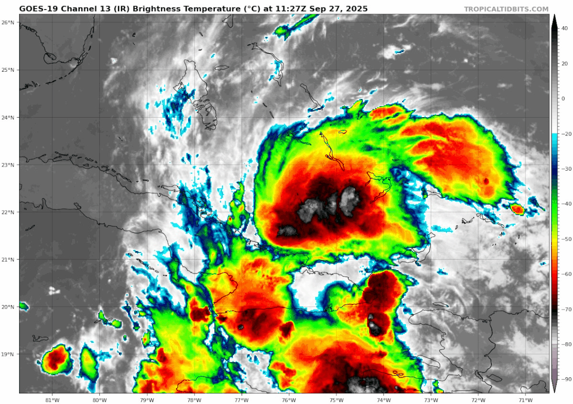
NATL: IMELDA - Post-Tropical - Discussion

Moderator: S2k Moderators

Message
Author
BobHarlem
Category 5
Category 5
Posts: 2566
Joined: Thu Oct 20, 2005 6:11 pm

Re: NATL: NINE - Potential Tropical Cyclone - Discussion

#281 Postby BobHarlem » Sat Sep 27, 2025 7:45 am

caneman wrote:
BobHarlem wrote:Scanning the ensemble members tThe faster/further north this forms the more likely for landfall, if it's slower or forms further south the more likely the ots scenarios are.


But..... I think it also might get much closer to Florida.


Majority of the convection is on the south/east on this one, most of Florida won't even notice it going by.
0 likes   

BobHarlem
Category 5
Category 5
Posts: 2566
Joined: Thu Oct 20, 2005 6:11 pm

Re: NATL: NINE - Potential Tropical Cyclone - Discussion

#282 Postby BobHarlem » Sat Sep 27, 2025 7:56 am

The northerly flow to the west of the system is moving at a fairly good clip, not sure how much it'lll shear it.
Image
0 likes   

User avatar
wxman57
Moderator-Pro Met
Moderator-Pro Met
Posts: 23080
Age: 68
Joined: Sat Jun 21, 2003 8:06 pm
Location: Houston, TX (southwest)

Re: NATL: NINE - Potential Tropical Cyclone - Discussion

#283 Postby wxman57 » Sat Sep 27, 2025 8:07 am

Hurricane chasers may be disappointed with Imelda. Looks like those dropsondes surrounding 94L provided data that indicates a slower forward speed. This will allow for Humberto to pass it to the east on Monday. Once that happens, the northward movement will stop and it'll begin accelerating eastward in the wake of Humberto. This may keep the center 120-150 miles off the coast of South Carolina. Some TS wind could brush the coast. Of course, if the center develops farther to the north or moves more quickly than models are predicting, there could still be a landfall in South Carolina.

Also, since very dry air will be flowing eastward from the Gulf across Florida tomorrow and Monday, Florida will not see much in the way of rain. Maybe some 25 mph northerly wind along the coast.
11 likes   

Sciencerocks
Category 5
Category 5
Posts: 10179
Age: 39
Joined: Thu Jul 06, 2017 1:51 am

Re: NATL: NINE - Potential Tropical Cyclone - Discussion

#284 Postby Sciencerocks » Sat Sep 27, 2025 8:37 am

Image
0 likes   

User avatar
Travorum
Category 2
Category 2
Posts: 623
Joined: Tue Sep 05, 2023 9:36 am
Location: Dunedin, FL

Re: NATL: NINE - Potential Tropical Cyclone - Discussion

#285 Postby Travorum » Sat Sep 27, 2025 8:39 am

With guidance/the storm itself ticking a little westward in the short term, PTC 9 could take a more favorable path over the warmer and higher TCHP gulfstream waters. That could provide a boost to intensification, depending on how much it can consolidate before the trough shears/dries it out.

Image
1 likes   

User avatar
HurricaneAndre2008
Category 1
Category 1
Posts: 356
Age: 28
Joined: Wed Jul 31, 2019 9:51 pm
Contact:

Re: NATL: NINE - Potential Tropical Cyclone - Discussion

#286 Postby HurricaneAndre2008 » Sat Sep 27, 2025 8:45 am

I think a tropical depression is forming yall.
1 likes   
Cindy(2005), Katrina(2005), Rita(2005), Erin(2007), Isaac(2012)

User avatar
HurricaneAndre2008
Category 1
Category 1
Posts: 356
Age: 28
Joined: Wed Jul 31, 2019 9:51 pm
Contact:

Re: NATL: NINE - Potential Tropical Cyclone - Discussion

#287 Postby HurricaneAndre2008 » Sat Sep 27, 2025 9:04 am

Logo
Menu
Sep. 27, 2025
13:59 Z
Map: Google Earth Logo Cesium Logo

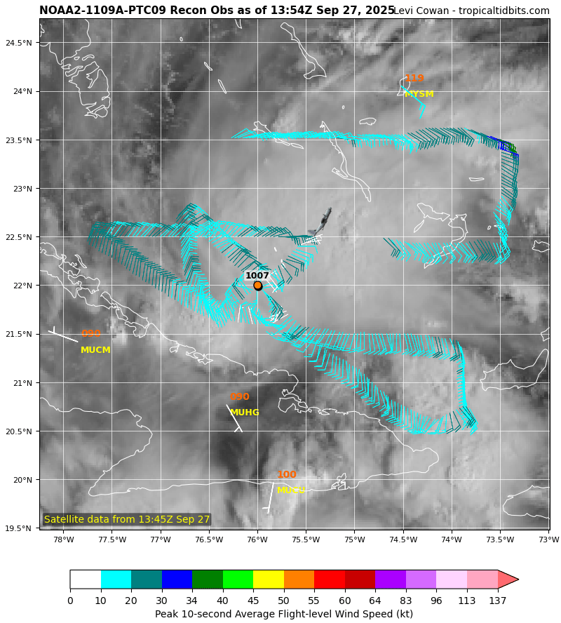
09/27 13:04 | 28 | 1007mb | 27kts (27kts) | --
Raw?
Note: "In. Flt" is max inbound flight level wind. "In. Sfc" is max inbound surface wind, estimated by SFMR or visually. If outbound wind is reported, then highest wind, inbound or outbound from center, is in parenthesis. Winds usually averaged over 10s period. Extrap. MSLPs have (e) next to them. Add missed obs.
Product: NOAA Vortex Message (URNT12 KWBC)
Transmitted: 27th day of the month at 13:54Z
Agency: National Oceanic and Atmospheric Administration (NOAA)
Aircraft: Lockheed WP-3D Orion (Reg. Num. N42RF)
Storm Number & Year: 09L in 2025
Mission Identifier: Ptc09 (flight in the North Atlantic basin)
Mission Number: 11
Observation Number: 28

A. Time of Center Fix: 27th day of the month at 13:04:10Z
B. Center Fix Coordinates: 22.00N 76.00W
B. Center Fix Location: 129 statute miles (208 km) to the ENE (71°) from Camagüey, Cuba.
C. Minimum Height at Standard Level: 3,144m (10,315ft) at 700mb
D. Minimum Sea Level Pressure: 1007mb (29.74 inHg)
E. Dropsonde Surface Wind at Center: From 125° at 25kts (From the SE at 29mph)
F. Eye Character: Not Available
G. Eye Shape: Not Available
H. Estimated (by SFMR or visually) Maximum Surface Wind Inbound: Not Available
I. Location & Time of the Estimated Maximum Surface Wind Inbound (Undecoded): NA
J. Maximum Flight Level Wind Inbound: From 146° at 27kts (From between the SE and SSE at 31.1mph)
K. Location & Time of the Maximum Flight Level Wind Inbound: 8 nautical miles to the SE (135°) of center fix at 13:02:18Z
L. Estimated (by SFMR or visually) Maximum Surface Wind Outbound: Not Available
M. Location & Time of the Estimated Maximum Surface Wind Outbound (Undecoded): NA
N. Maximum Flight Level Wind Outbound: From 40° at 25kts (From the NE at 28.8mph)
O. Location & Time of the Maximum Flight Level Wind Outbound: 16 nautical miles (18 statute miles) to the NW (314°) of center fix at 13:08:03Z
P. Maximum Flight Level Temp & Pressure Altitude Outside Eye: 10°C (50°F) at a pressure alt. of 3,056m (10,026ft)
Q. Maximum Flight Level Temp & Pressure Altitude Inside Eye: 11°C (52°F) at a pressure alt. of 3,058m (10,033ft)
R. Dewpoint Temp (collected at same location as temp inside eye): 12°C (54°F)
R. Sea Surface Temp (collected at same location as temp inside eye): Not Available
S. Fix Determined By: Penetration, Wind, Pressure and Temperature
S. Fix Level: 700mb
T. Navigational Fix Accuracy: 0.01 nautical miles
T. Meteorological Accuracy: 1.5 nautical miles

Remarks Section:

Maximum Flight Level Wind: 27kts (~ 31.1mph) which was observed 8 nautical miles to the SE (135°) from the flight level center at 13:02:18Z :spam:
2 likes   
Cindy(2005), Katrina(2005), Rita(2005), Erin(2007), Isaac(2012)

User avatar
Zonacane
Category 1
Category 1
Posts: 405
Joined: Tue Aug 03, 2021 2:23 pm

Re: NATL: NINE - Potential Tropical Cyclone - Discussion

#288 Postby Zonacane » Sat Sep 27, 2025 9:05 am

It looks like the northern end of the wave axis is consolidating into Imelda; I'm not sure how the southern end managed to cling on despite being separated for multiple days.
1 likes   

User avatar
blp
Category 5
Category 5
Posts: 2880
Age: 47
Joined: Thu Sep 09, 2004 7:51 pm
Location: Miami, FL
Contact:

Re: NATL: NINE - Potential Tropical Cyclone - Discussion

#289 Postby blp » Sat Sep 27, 2025 9:08 am

Bingo. ready for lift off.

Image
3 likes   
The following post is NOT an official forecast and should not be used as such. It is just the opinion of the poster and may or may not be backed by sound meteorological data. It is NOT endorsed by any professional institution including storm2k.org For Official Information please refer to the NHC and NWS products.

skillz305
Category 1
Category 1
Posts: 312
Joined: Sat Sep 08, 2018 11:10 am
Location: Miami, Florida --> Vero Beach, Florida

Re: NATL: NINE - Potential Tropical Cyclone - Discussion

#290 Postby skillz305 » Sat Sep 27, 2025 9:11 am

Why can’t I stop checking to see how close to Floridas east coast this might get? Been an insane storm to predict with Humberto weighing heavily on the track. From ULL cutting off Florida, to a stall offshore the Carolinas, to a sudden stop and shot East out to sea. How can I not keep checking? I just don’t want any surprises if this storm decides to ride just outside Florida east coast line. And remember! This is 48 hours out or so?! 2025 was so quiet and said hold my beer here’s a jigsaw puzzle.
3 likes   
:flag:Hurricanes: Andrew 1992 - Irene 1999 - Frances 2004 - Jeanne 2004 - Katrina 2005 - Wilma 2005 - Matthew 2016 - Irma 2017 - Ian 2022 - Nicole 2022 - Milton 2024

User avatar
Buck
S2K Supporter
S2K Supporter
Posts: 1199
Joined: Fri Sep 10, 2004 12:04 pm
Location: Atlanta, GA

Re: NATL: NINE - Potential Tropical Cyclone - Discussion

#291 Postby Buck » Sat Sep 27, 2025 9:17 am

That’s closed enough for a TD at 11 I’d imagine.
2 likes   

User avatar
Zonacane
Category 1
Category 1
Posts: 405
Joined: Tue Aug 03, 2021 2:23 pm

Re: NATL: NINE - Potential Tropical Cyclone - Discussion

#292 Postby Zonacane » Sat Sep 27, 2025 9:18 am

skillz305 wrote:Why can’t I stop checking to see how close to Floridas east coast this might get? Been an insane storm to predict with Humberto weighing heavily on the track. From ULL cutting off Florida, to a stall offshore the Carolinas, to a sudden stop and shot East out to sea. How can I not keep checking? I just don’t want any surprises if this storm decides to ride just outside Florida east coast line. And remember! This is 48 hours out or so?! 2025 was so quiet and said hold my beer here’s a jigsaw puzzle.

Because tropical cyclones are the most dangerous storms on Earth, you live in an area prone to getting them and are also vulnerable to them. I have family all over the Florida east coast, and I've been constantly checking on this storm. It is understandable to be concerned, given the uncertainty surrounding this forecast.
2 likes   

User avatar
Beef Stew
Category 2
Category 2
Posts: 642
Joined: Sat May 30, 2020 11:31 am
Location: South Florida

Re: NATL: NINE - Potential Tropical Cyclone - Discussion

#293 Postby Beef Stew » Sat Sep 27, 2025 9:19 am

Should be enough for the official designation at the next advisory
1 likes   

User avatar
GCANE
S2K Supporter
S2K Supporter
Posts: 12072
Joined: Mon Oct 22, 2007 8:03 am

Re: NATL: NINE - Potential Tropical Cyclone - Discussion

#294 Postby GCANE » Sat Sep 27, 2025 9:36 am

ScottNAtlanta wrote:Looking at where the vorticity is located, It is a bit east of where the 8am fix is located
https://tropic.ssec.wisc.edu/real-time/atlantic/winds/wg8vor5.GIF
https://tropic.ssec.wisc.edu/real-time/atlantic/winds/wg8vor.GIF


Its elongated in the same direction of a wave.
Land interaction is keeping it from closing off.
1 likes   

User avatar
Zonacane
Category 1
Category 1
Posts: 405
Joined: Tue Aug 03, 2021 2:23 pm

Re: NATL: NINE - Potential Tropical Cyclone - Discussion

#295 Postby Zonacane » Sat Sep 27, 2025 9:42 am

GCANE wrote:
ScottNAtlanta wrote:Looking at where the vorticity is located, It is a bit east of where the 8am fix is located
https://tropic.ssec.wisc.edu/real-time/atlantic/winds/wg8vor5.GIF
https://tropic.ssec.wisc.edu/real-time/atlantic/winds/wg8vor.GIF


Its elongated in the same direction of a wave.
Land interaction is keeping it from closing off.

Morning GCANE, quick question, do you have any idea how the southern end of the wave axis has clung on for the past few days, given that the two halves of the wave were physically separated?
1 likes   

Hugo1989
Tropical Storm
Tropical Storm
Posts: 150
Joined: Mon Jun 14, 2010 9:09 am

Re: NATL: NINE - Potential Tropical Cyclone - Discussion

#296 Postby Hugo1989 » Sat Sep 27, 2025 9:47 am

Is still enlongated we'll see
1 likes   

User avatar
AnnularCane
S2K Supporter
S2K Supporter
Posts: 2945
Joined: Thu Jun 08, 2006 9:18 am
Location: Wytheville, VA

Re: NATL: NINE - Potential Tropical Cyclone - Discussion

#297 Postby AnnularCane » Sat Sep 27, 2025 9:49 am

skillz305 wrote:Why can’t I stop checking to see how close to Floridas east coast this might get? Been an insane storm to predict with Humberto weighing heavily on the track. From ULL cutting off Florida, to a stall offshore the Carolinas, to a sudden stop and shot East out to sea. How can I not keep checking? I just don’t want any surprises if this storm decides to ride just outside Florida east coast line. And remember! This is 48 hours out or so?! 2025 was so quiet and said hold my beer here’s a jigsaw puzzle.


All that before she's even born. :lol:
2 likes   
"But it never rained rain. It never snowed snow. And it never blew just wind. It rained things like soup and juice. It snowed mashed potatoes and green peas. And sometimes the wind blew in storms of hamburgers." -- Judi Barrett, Cloudy with a Chance of Meatballs

User avatar
StormWeather
Category 1
Category 1
Posts: 458
Joined: Wed Jun 05, 2024 2:34 pm

Re: NATL: NINE - Tropical Depression - Discussion

#298 Postby StormWeather » Sat Sep 27, 2025 9:50 am

Is now a Tropical Depression
2 likes   
Just an average cyclone tracker

The posts in this forum are NOT official forecasts and should not be used as such. They are just the opinion of the poster and may or may not be backed by sound meteorological data. They are NOT endorsed by any professional institution or storm2k.org. For official information, please refer to the NHC and NWS products

User avatar
ScottNAtlanta
Category 5
Category 5
Posts: 2535
Joined: Sat May 25, 2013 3:11 pm
Location: Atlanta, GA

Re: NATL: NINE - Potential Tropical Cyclone - Discussion

#299 Postby ScottNAtlanta » Sat Sep 27, 2025 9:50 am

skillz305 wrote:Why can’t I stop checking to see how close to Floridas east coast this might get? Been an insane storm to predict with Humberto weighing heavily on the track. From ULL cutting off Florida, to a stall offshore the Carolinas, to a sudden stop and shot East out to sea. How can I not keep checking? I just don’t want any surprises if this storm decides to ride just outside Florida east coast line. And remember! This is 48 hours out or so?! 2025 was so quiet and said hold my beer here’s a jigsaw puzzle.

...or going to the NHC site at 10:45 and keep refreshing the page until the 11am comes out :lol:
1 likes   
The posts in this forum are NOT official forecast and should not be used as such. They are just the opinion of the poster and may or may not be backed by sound meteorological data. They are NOT endorsed by any professional institution or storm2k.org. For official information, please refer to the NHC and NWS products.

User avatar
Zonacane
Category 1
Category 1
Posts: 405
Joined: Tue Aug 03, 2021 2:23 pm

Re: NATL: NINE - Potential Tropical Cyclone - Discussion

#300 Postby Zonacane » Sat Sep 27, 2025 9:51 am

Hugo1989 wrote:Is still enlongated we'll see

Elongated (seriously, how on Earth is the southern end of the wave axis still hanging around??), but there is an actual closed center now.
2 likes   


Return to “2025”

Who is online

Users browsing this forum: No registered users and 48 guests