2020 Global Model Runs Discussion (Out thru day 16)
Moderator: S2k Moderators
Forum rules

The posts in this forum are NOT official forecasts and should not be used as such. They are just the opinion of the poster and may or may not be backed by sound meteorological data. They are NOT endorsed by any professional institution or STORM2K. For official information, please refer to products from the National Hurricane Center and National Weather Service.
-
Hurricaneman

- Category 5

- Posts: 7404
- Age: 45
- Joined: Tue Aug 31, 2004 3:24 pm
- Location: central florida
-
toad strangler

- S2K Supporter

- Posts: 4546
- Joined: Sun Jul 28, 2013 3:09 pm
- Location: Earth
- Contact:
Re: 2020 Global Model Runs Discussion (Out thru day 16)
Hurricaneman wrote:A good analog could be Irene 1999
There isn't any good analog yet. There is absolutely no confidence in anything yet.
2 likes
My Weather Station
https://www.wunderground.com/dashboard/pws/KFLPORTS603
https://www.wunderground.com/dashboard/pws/KFLPORTS603
-
Hurricaneman
- Category 5
- Posts: 7404
- Age: 45
- Joined: Tue Aug 31, 2004 3:24 pm
- Location: central florida
Re: 2020 Global Model Runs Discussion (Out thru day 16)
toad strangler wrote:Hurricaneman wrote:A good analog could be Irene 1999
There isn't any good analog yet. There is absolutely no confidence in anything yet.
Thats why it could be and not an absolute, we'll know more by Monday or Tuesday most likely
1 likes
-
CrazyC83
- Professional-Met

- Posts: 34315
- Joined: Tue Mar 07, 2006 11:57 pm
- Location: Deep South, for the first time!
Re: 2020 Global Model Runs Discussion (Out thru day 16)
I know a Nor'easter-type low could develop Wednesday or Thursday off the Carolina coast. Is there any chance that could gain (sub)tropical characteristics? Time will be the enemy as it will likely only have about 24 hours before it goes inland in New England.
2 likes
-
Shell Mound
- Category 5
- Posts: 2432
- Age: 33
- Joined: Thu Sep 07, 2017 3:39 pm
- Location: St. Petersburg, FL → Scandinavia
Re: 2020 Global Model Runs Discussion (Out thru day 16)
https://twitter.com/AndyHazelton/status/1310002587324895233
https://twitter.com/TrackTropical/status/1310001342774218753
https://twitter.com/HenryLWilson1/status/1310014035459440646
https://twitter.com/TrackTropical/status/1310001342774218753
https://twitter.com/HenryLWilson1/status/1310014035459440646
2 likes
CVW / MiamiensisWx / Shell Mound
The posts in this forum are NOT official forecasts and should not be used as such. They are just the opinion of the poster and may or may not be backed by sound meteorological data. They are NOT endorsed by any professional institution or STORM2K. For official information, please refer to products from the NHC and NWS.
-
Shell Mound
- Category 5
- Posts: 2432
- Age: 33
- Joined: Thu Sep 07, 2017 3:39 pm
- Location: St. Petersburg, FL → Scandinavia
Re: 2020 Global Model Runs Discussion (Out thru day 16)
robbielyn wrote:TheStormExpert wrote:Don’t count on a hurricane coming out of the Western Caribbean next week. May have to wait until later in the month we see something more significant.
https://twitter.com/derekortt/status/1309987091892367360
well then this will probably hit the peninsula. We always get the sheared slop
Note that the models are showing a strong subtropical jet over the Gulf of Mexico, which is rather atypical of La Niña, but very typical of El Niño. #2020
2 likes
CVW / MiamiensisWx / Shell Mound
The posts in this forum are NOT official forecasts and should not be used as such. They are just the opinion of the poster and may or may not be backed by sound meteorological data. They are NOT endorsed by any professional institution or STORM2K. For official information, please refer to products from the NHC and NWS.
-
cheezyWXguy

- Category 5
- Posts: 6282
- Joined: Mon Feb 13, 2006 12:29 am
- Location: Dallas, TX
Re: 2020 Global Model Runs Discussion (Out thru day 16)
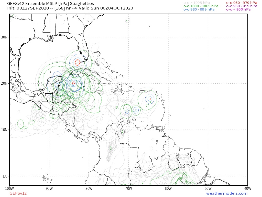
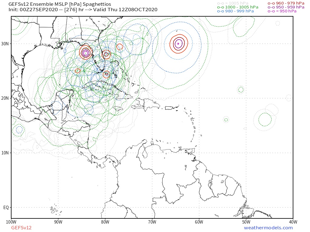
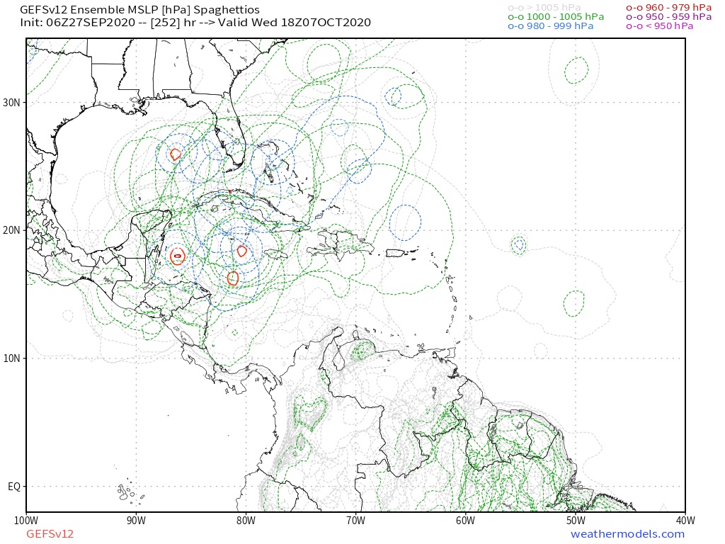
Gefs a little more enthusiastic this go-around, but cmc is much less enthusiastic
0 likes

Re: 2020 Global Model Runs Discussion (Out thru day 16)
Yeah I’m not buying this strong shear front coming all the way down to the Yucatan and Cuba. There will be some stability in the air but I think these modes showing so much shear and air stability are not taking the La Niña into account.
There’s just not awhole lot to take from all of this other than there will be some type of cold front with some shear and almost surely some type of TC development.
There’s just not awhole lot to take from all of this other than there will be some type of cold front with some shear and almost surely some type of TC development.
0 likes
-
CrazyC83
- Professional-Met
- Posts: 34315
- Joined: Tue Mar 07, 2006 11:57 pm
- Location: Deep South, for the first time!
Re: 2020 Global Model Runs Discussion (Out thru day 16)
ClarCari wrote:Yeah I’m not buying this strong shear front coming all the way down to the Yucatan and Cuba. There will be some stability in the air but I think these modes showing so much shear and air stability are not taking the La Niña into account.
There’s just not awhole lot to take from all of this other than there will be some type of cold front with some shear and almost surely some type of TC development.
The bottom of the front in bathtub water could itself become a mechanism for development.
4 likes
Re: 2020 Global Model Runs Discussion (Out thru day 16)
CrazyC83 wrote:ClarCari wrote:Yeah I’m not buying this strong shear front coming all the way down to the Yucatan and Cuba. There will be some stability in the air but I think these modes showing so much shear and air stability are not taking the La Niña into account.
There’s just not awhole lot to take from all of this other than there will be some type of cold front with some shear and almost surely some type of TC development.
The bottom of the front in bathtub water could itself become a mechanism for development.
Oh absolutely!
I’m just very suspicious of models that start predicting conditions typical of El Niño years as it gives the impression that sometimes they don’t catch up to the changing ENSO. Another example would be models like the GFS sometimes overhyping the EPAC activity this year despite increasing La Niña conditions proving otherwise.
1 likes
Re: 2020 Global Model Runs Discussion (Out thru day 16)
The 0Z Euro says that all of those GFS runs last week with an Oct 3-4 storm genesis that later became hurricanes were on crack.
It appears that any Caribbean genesis would likely be later. The ENSO based analogs support the genesis being as late as 10/15-20. It appears we may be watching the W Caribbean very closely for one or two potential geneses for another 3 weeks or so. Don't let your guard down.
It appears that any Caribbean genesis would likely be later. The ENSO based analogs support the genesis being as late as 10/15-20. It appears we may be watching the W Caribbean very closely for one or two potential geneses for another 3 weeks or so. Don't let your guard down.
Last edited by LarryWx on Sun Sep 27, 2020 2:28 am, edited 1 time in total.
0 likes
Personal Forecast Disclaimer:
The posts in this forum are NOT official forecasts and should not be used as such. They are just the opinion of the poster and may or may not be backed by sound meteorological data. They are NOT endorsed by any professional institution or storm2k.org. For official information, please refer to the NHC and NWS products.
The posts in this forum are NOT official forecasts and should not be used as such. They are just the opinion of the poster and may or may not be backed by sound meteorological data. They are NOT endorsed by any professional institution or storm2k.org. For official information, please refer to the NHC and NWS products.
-
Loveweather12
- Tropical Storm

- Posts: 136
- Joined: Thu Aug 20, 2020 2:37 pm
Re: 2020 Global Model Runs Discussion (Out thru day 16)
I heard that model hasn’t been good this year? I’m still watching around the 4 of next month. Not going to let one model throw me off track & others shouldn’t either
LarryWx wrote:The 0Z Euro says that all of those GFS runs last week with an Oct 3-4 storm genesis that later became hurricanes were on crack.
It appears that any Caribbean genesis would likely be later. The ENSO based analogs support the genesis being as late as 10/15-20. It appears we may be watching the W Caribbean very closely for another 3 weeks or so. Don't let your guard down.
0 likes
-
SFLcane

- S2K Supporter
- Posts: 10281
- Age: 48
- Joined: Sat Jun 05, 2010 1:44 pm
- Location: Lake Worth Florida
Re: 2020 Global Model Runs Discussion (Out thru day 16)
cheezyWXguy wrote:Gefs a little more enthusiastic this go-around, but cmc is much less enthusiastic
1 likes
Re: 2020 Global Model Runs Discussion (Out thru day 16)
Loveweather12 wrote:I heard that model hasn’t been good this year? I’m still watching around the 4 of next month. Not going to let one model throw me off track & others shouldn’t eitherLarryWx wrote:The 0Z Euro says that all of those GFS runs last week with an Oct 3-4 storm genesis that later became hurricanes were on crack.
It appears that any Caribbean genesis would likely be later. The ENSO based analogs support the genesis being as late as 10/15-20. It appears we may be watching the W Caribbean very closely for another 3 weeks or so. Don't let your guard down.
The GFS has put an end to those 10/3-4 geneses and is now waiting at least til 10/5-6.
Indeed, nobody should take their eyes off the Caribbean during any of Oct. But it appears increasingly likely to me that all of those GFS runs were at least too early with a genesis. We'll know in about a week.
Last edited by LarryWx on Sun Sep 27, 2020 2:37 am, edited 3 times in total.
0 likes
Personal Forecast Disclaimer:
The posts in this forum are NOT official forecasts and should not be used as such. They are just the opinion of the poster and may or may not be backed by sound meteorological data. They are NOT endorsed by any professional institution or storm2k.org. For official information, please refer to the NHC and NWS products.
The posts in this forum are NOT official forecasts and should not be used as such. They are just the opinion of the poster and may or may not be backed by sound meteorological data. They are NOT endorsed by any professional institution or storm2k.org. For official information, please refer to the NHC and NWS products.

Re: 2020 Global Model Runs Discussion (Out thru day 16)
GEFS P look like the old CMC wants to ramp things up too much in my opinion.

2 likes
The following post is NOT an official forecast and should not be used as such. It is just the opinion of the poster and may or may not be backed by sound meteorological data. It is NOT endorsed by any professional institution including storm2k.org For Official Information please refer to the NHC and NWS products.
Re: 2020 Global Model Runs Discussion (Out thru day 16)
blp wrote:GEFS P look like the old CMC wants to ramp things up too much in my opinion.
https://i.ibb.co/NKvXs0C/8e4bdb55-b6d0-460d-9a3b-4de993dabad0.gif
Yeah, I don't have confidence in the para-GFS as it appears to be too genesis happy overall. Same goes for the newly upgraded GEFS. It will miss fewer geneses but it will have more fake storms.
The 0Z EPS continues with only a handful of sub 1000 mb storms. It has ~8 out of 51 or 16%. So, nothing like the GEFS.
Regardless, I do think there will be 1-2 geneses in early to mid Oct.
0 likes
Personal Forecast Disclaimer:
The posts in this forum are NOT official forecasts and should not be used as such. They are just the opinion of the poster and may or may not be backed by sound meteorological data. They are NOT endorsed by any professional institution or storm2k.org. For official information, please refer to the NHC and NWS products.
The posts in this forum are NOT official forecasts and should not be used as such. They are just the opinion of the poster and may or may not be backed by sound meteorological data. They are NOT endorsed by any professional institution or storm2k.org. For official information, please refer to the NHC and NWS products.
-
TheStormExpert
Re: 2020 Global Model Runs Discussion (Out thru day 16)
blp wrote:GEFS P look like the old CMC wants to ramp things up too much in my opinion.
https://i.ibb.co/NKvXs0C/8e4bdb55-b6d0-460d-9a3b-4de993dabad0.gif
Didn’t we just get an upgrade to the GFS the other day? If so than what’s this?
0 likes
-
Shell Mound
- Category 5
- Posts: 2432
- Age: 33
- Joined: Thu Sep 07, 2017 3:39 pm
- Location: St. Petersburg, FL → Scandinavia
Re: 2020 Global Model Runs Discussion (Out thru day 16)
There’s been a wall of shear over the western Caribbean since at least 2011. Why should it let up just now? Furthermore, shear thus far has been consistently higher than in a typical Niña year, hence lower-than-expected ACE to date. At this point I think the western Caribbean will continue to be a “dead zone” as far as major hurricanes are concerned, owing to the influence of Niño-like TUTT and STJ activity. As someone previously mentioned, another Michael in the Gulf of Mexico would be exceptional.
1 likes
CVW / MiamiensisWx / Shell Mound
The posts in this forum are NOT official forecasts and should not be used as such. They are just the opinion of the poster and may or may not be backed by sound meteorological data. They are NOT endorsed by any professional institution or STORM2K. For official information, please refer to products from the NHC and NWS.
-
SFLcane
- S2K Supporter
- Posts: 10281
- Age: 48
- Joined: Sat Jun 05, 2010 1:44 pm
- Location: Lake Worth Florida
Re: 2020 Global Model Runs Discussion (Out thru day 16)
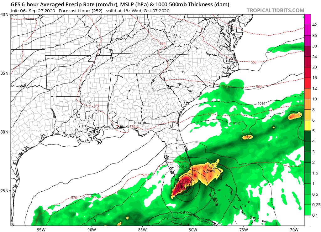
06z GFS this morning with perhaps a minimal Cat 1 hurricane into SFL. I am becoming more confident something is gonna form This upcoming weekend.
0 likes
-
MarioProtVI
- Category 5
- Posts: 1034
- Age: 24
- Joined: Sun Sep 29, 2019 7:33 pm
- Location: New Jersey
Re: 2020 Global Model Runs Discussion (Out thru day 16)
Shell Mound wrote:There’s been a wall of shear over the western Caribbean since at least 2011. Why should it let up just now? Furthermore, shear thus far has been consistently higher than in a typical Niña year, hence lower-than-expected ACE to date. At this point I think the western Caribbean will continue to be a “dead zone” as far as major hurricanes are concerned, owing to the influence of Niño-like TUTT and STJ activity. As someone previously mentioned, another Michael in the Gulf of Mexico would be exceptional.
We still have the entire month of October to get through, and also the models are probably not taking the La Niña into effect (particularly the GFS it seems). Don’t give up at all yet because 2020 is known for surprises, and the Western Caribbean has shown it is favourable this year more then other years with Marco and Nana (the former being a strong tropical storm before exiting and the latter becoming a brief C1).
2 likes
Who is online
Users browsing this forum: No registered users and 219 guests