DISCUSSION...
AS WAS SAID SO APTLY BY THE PREVIOUS DAY FORECASTER...HOT AND
RAINFREE THE NEXT 7 DAYS. UPPER RIDGE OVER TX TO SLOWLY SHIFT
EAST-NORTHEAST STRENGTHENING SLIGHTLY WEDNESDAY AND THURSDAY. 850
PROG TEMPS HAVE DIPPED TO 19-21C AND PROFILES SHOULD BE WELL MIXED
DURING THE AFTERNOON LIMITING THE HEAT INDICIES WITH THE
INTRODUCTION OF THE DRY AIR ALOFT. HEAT INDICIES SHOULD TOP OUT AT
101-104 DURING THE PEAK OF HEATING. TROPICS STILL LOOKING QUIET.
THE DRY/DROUGHT CONDITIONS ACROSS THE REGION CONTINUE TO WORSEN
ACROSS SOUTHEAST TEXAS. MUCH OF THE AREA HASN`T SEEN SIGNIFICANT
RAINFALL SINCE THE END OF APRIL (EXCLUDING EXTREME NE AND SW COUNTIES).
NO SIGNIFICANT RAINFALL EXPECTED THROUGH DAY 8 TO 10 AND PERHAPS
EVEN LONGER.
SE TX/SW LA weather: Much cooler and WET after Tuesday
Moderator: S2k Moderators
Forum rules

The posts in this forum are NOT official forecast and should not be used as such. They are just the opinion of the poster and may or may not be backed by sound meteorological data. They are NOT endorsed by any professional institution or STORM2K.
-
Ed Mahmoud
Re: SE TX/SW LA weather: Summer Pattern-HOT!!!
0 likes
-
Yankeegirl

- Category 5

- Posts: 3417
- Age: 50
- Joined: Sun May 23, 2004 11:59 pm
- Location: Cy-Fair, Northwest Houston
- Contact:
-
Ed Mahmoud
Re:
Yankeegirl wrote:This is crazy! Its WAY too hot!! What I wouldn't do for a nice storm to move on in.... I think its about time for us Texans to start doing a rain dance in the front yard.... The heat is killing me!! I dont remember it being this hot in June before.... ?
1980 temps were in excess of 110ºF in the DFW area before the Solstice.
Following is 9 years old, and therefore has one important no longer valid bit of data
ALTHOUGH THE PAST TWO SUMMERS HAVE BEEN UNSEASONABLY WARM...NEITHER
1998 OR 1999 COULD SUPPLANT 1980 AS THE WARMEST SUMMER FOR THE
HOUSTON METROPOLITAN AREA. THE 1980 HEAT WAVE BEGAN IN EARLY JUNE
AS A STRONG RIDGE OF HIGH PRESSURE PARKED ITSELF OVER THE CENTRAL
AND SOUTHERN PLAINS. THIS FEATURE INTENSIFIED AND REMAINED NEARLY
STATIONARY FOR JUNE AND JULY. THIS HEAT WAVE AFFECTED MUCH OF THE
EASTERN TWO-THIRDS OF THE NATION WITH RECORD HIGH TEMPERATURES AND
DROUGHT CONDITIONS AFFECTING MOST OF THE CENTRAL PLAINS...THE GREAT
LAKES AND THE DEEP SOUTH. STAGGERING LOSSES TO AGRICULTURE AND
LIVESTOCK WERE REPORTED DUE TO THE INTENSE HEAT AND DROUGHT.
THE HOUSTON AREA ENDURED BRUTALLY HOT TEMPERATURES TOWARD THE END OF
JUNE AND MOST OF JULY. HOW HOT? BEGINNING JUNE 25TH 1980...THE
TEMPERATURE REACHED 100 DEGREES 23 OUT OF THE NEXT 25 DAYS. A BRIEF
RESPITE FROM THE HEAT OCCURRED ON THE 4TH OF JULY WHEN THE
TEMPERATURE ONLY ROSE TO 99 DEGREES. THE HEAT WAVE APPROACHED IT'S
ZENITH AROUND JULY 12TH AND TEMPERATURES RETURNED TO MORE SEASONAL
NORMALS AROUND JULY 20TH. IN AN IRONIC TWIST OF FATE...THE HIGH
TEMPERATURE ON JULY 28TH 1980 WAS 83 DEGREES WHICH IS THE LOWEST
HIGH TEMPERATURE EVER RECORDED FOR THE DATE.
THE TEMPERATURE REACHED OR EXCEEDED 100 DEGREES FOR 14 CONSECUTIVE
DAYS BEGINNING JULY 6 1980 AND ENDING ON THE 19TH. IN 1998...THERE
WERE 11 CONSECUTIVE DAYS OF 100 DEGREE TEMPERATURES AND THIS
OCCURRED FROM JULY 26TH THROUGH AUGUST 5TH. THE WARMEST TEMPERATURE
RECORDED IN HOUSTON FOR THE THREE SUMMERS WAS 107 DEGREES AND THIS
OCCURRED ON AUGUST 23 1980. THE 107 DEGREE TEMPERATURE IS THE
ALL-TIME WARMEST TEMPERATURE EVER RECORDED IN HOUSTON AND WAS PART
OF A 5 DAY STRETCH IN WHICH THE AVERAGE HIGH TEMPERATURE WAS 104
DEGREES.
0 likes

-
Ed Mahmoud
Re: SE TX/SW LA weather: Summer Pattern-HOT!!!
If the warm ENSO continues into Winter, it could be wetter than normal then...
5, 10, 15 day 850 mb temp anomalies aren't happy...
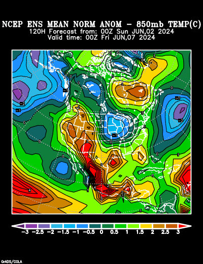
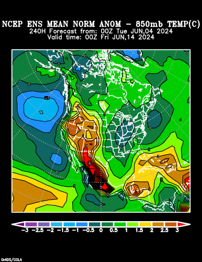
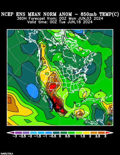
Kinda dry...
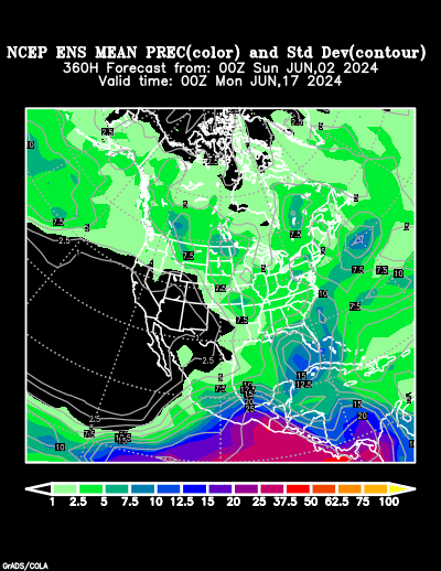
5, 10, 15 day 850 mb temp anomalies aren't happy...
Kinda dry...
0 likes
-
southerngale

- Retired Staff

- Posts: 27418
- Joined: Thu Oct 10, 2002 1:27 am
- Location: Southeast Texas (Beaumont area)
Re:
Yankeegirl wrote:This is crazy! Its WAY too hot!! What I wouldn't do for a nice storm to move on in.... I think its about time for us Texans to start doing a rain dance in the front yard.... The heat is killing me!! I dont remember it being this hot in June before.... ?
It really is hot out there!
 August temps in June aren't so nice. It's been feeling nice in the evenings, though.
We had a decent amount of rain in early June, the 2nd and 3rd I believe, but not a drop since. It's not something I have to say very often, but we're gonna need some rain soon as well. Everything still looks good around here, but if it's weeks before we get any rain, that could be another story.
0 likes
-
srainhoutx

- S2K Supporter

- Posts: 6919
- Age: 68
- Joined: Sun Jan 14, 2007 11:34 am
- Location: Haywood County, NC
- Contact:
Re: SE TX/SW LA weather: Summer Pattern-HOT!!!
Azaming that we can go from major flooding in April to nothing isn't it. The only "hope" is that we see an Upper Air Pattern change with the ridge moving. The ECMWF did "hint" this today. I'll get excited when a bit more guidance suggests this. FYI: our pool is cool 91 degrees.
0 likes
-
Ed Mahmoud
Re: SE TX/SW LA weather: Summer Pattern-HOT!!!
srainhoutx wrote:Azaming that we can go from major flooding in April to nothing isn't it. The only "hope" is that we see an Upper Air Pattern change with the ridge moving. The ECMWF did "hint" this today. I'll get excited when a bit more guidance suggests this. FYI: our pool is cool 91 degrees.

A trough!
I wonder what the Euro ensembles show. Most of the GFS ensemble members don't look particularly chilly.
0 likes
-
Yankeegirl
- Category 5
- Posts: 3417
- Age: 50
- Joined: Sun May 23, 2004 11:59 pm
- Location: Cy-Fair, Northwest Houston
- Contact:
-
srainhoutx
- S2K Supporter
- Posts: 6919
- Age: 68
- Joined: Sun Jan 14, 2007 11:34 am
- Location: Haywood County, NC
- Contact:
Re:
Yankeegirl wrote:Well we are going out to west Texas in 3 weeks to go tubing in Cancan, near the Frio River... and from what I heard it is low... Is there a site you can go to to check the river levels?
http://waterdata.usgs.gov/tx/nwis/uv/?site_no=08195000
0 likes
-
Yankeegirl
- Category 5
- Posts: 3417
- Age: 50
- Joined: Sun May 23, 2004 11:59 pm
- Location: Cy-Fair, Northwest Houston
- Contact:
-
vbhoutex

- Storm2k Executive

- Posts: 29149
- Age: 74
- Joined: Wed Oct 09, 2002 11:31 pm
- Location: Cypress, TX
- Contact:
Re:
jasons wrote:It's getting pretty critical for us now. If we don't get some moisture in here soon, then we don't have good chances for getting our usual Florida-like daily seabreeze activity from June - early September....and if we can't get that....well, we got nothin'...
And I haven't seen a hint of sea breeze activity for at least a couple of weeks. Not looking good at all for us if this continues much longer. Rain so far this month at our house? 0"!!
0 likes
-
srainhoutx
- S2K Supporter
- Posts: 6919
- Age: 68
- Joined: Sun Jan 14, 2007 11:34 am
- Location: Haywood County, NC
- Contact:
Re: SE TX/SW LA weather: Summer Pattern-HOT!!!
I see the latest ECMWF has changed it's tune and builds the Upper Ridge and doesn't move it. HGX morning AFD echos this...
AREA FORECAST DISCUSSION
NATIONAL WEATHER SERVICE HOUSTON/GALVESTON TX
300 AM CDT TUE JUN 16 2009
.DISCUSSION...
ABOVE NORMAL TEMPERATURES AND BELOW NORMAL PRECIP SHOULD CONTINUE
FOR THE NEXT WEEK. AN UPPER LEVEL DEATH RIDGE STRETCHES FROM S TX
ACROSS THE NORTHERN GULF THIS MORNING. NO MATTER WHICH FORECAST
MODEL YOU PICK...THE DEATH RIDGE CENTER RE-LOCATES OVER THE
NORTHERN GULF BY THE WEEKEND. THE DEATH RIDGE THEN RETROGRADES
BACK OVER C TX BY EARLY NEXT WEEK. GFS MODEL RUN ACCUMULATED
PRECIP SHOWS NO PRECIP OVER HGX AND SURROUNDING CWA`S. IT APPEARS
SAFE TO SAY THAT THERE WILL NOT BE ANY RAIN ANYTIME SOON. ABOVE
NORMAL TEMPS ALSO LOOK LIKE A SAFE BET...THE FORECAST WILL KEEP
MIN TEMPS IN LINE WITH LATEST GFS GUIDANCE AND A DEGREE OR TWO
WARMER THAN GUIDANCE FOR MAX TEMPS. IF DROUGHT CONDITIONS OVER TX
ARE NOT BAD ENOUGH...THEY WILL ONLY GET WORSE GIVEN THIS
PERSISTENT SUMMER TIME PATTERN. THE ONLY OTHER POTENTIAL HAZARD
WILL BE HEAT RELATED ILLNESSES DUE TO HEAT INDEX VALUES IN THE
LOW 100S EACH DAY. IT SHOULD GO WITHOUT SAYING...BE SURE TO DRINK
WATER AND STAY HYDRATED IF YOU PARTICIPATE IN ANY OUTDOOR
ACTIVITIES.
Morning e-mail from Jeff Lindner...
Not to many ways to say hot and dry….as persistence rules the forecast.
Ever persistent upper ridge has a firm grip on SE TX and much of TX for that fact. Center of 500mb high is from S TX to SW LA with Gulf surface ridge supplying SE onshore flow allowing sultry low 70 degree dewpoints to mix with the very warm afternoon highs (upper 90’s). Positive feedback processes of drying grounds and warming surface is helping to build the ridge and likely keep it anchored in our area. Very dry air above the morning inversion around 3,000 ft is mixed down by late morning evaporating the mid morning cumulus field and by mid afternoon skies are almost cloudless allowing the strong solar angle to bake the surface and warm temps into the upper 90’s. Afternoon heat index values have been in the 99-104 range and overnight lows continue to fall below 80 some local heat advisory criteria is not being met although locations around Matagorda Bay (where surface dewpoints are higher) are likely flirting with advisory criteria. Heat stresses will continue to build and outdoor activity from about 1100am until 500pm should be limited.
I suppose everyone would like a glimmer of hope for some much needed rainfall and cooler highs…but I have none to offer this go around. Center of the ridge will migrate slightly eastward this weekend, but closest convection would be over NE Mexico…and then early next week the center of the high builds back into central Texas. Will continue to see highs in the 96-100 degree range through early next week with a 0 chance for rainfall.
Long range GFS shows an easterly wave possibly affecting the area around July 1….that may be our next chance for rainfall.
It is interesting to note that since the flooding rains in late April only .40 of an inch of rain has fallen with exceptions being around Matagorda Bay and across our NE counties that saw some rainfall in May. The dryness from Oct 08 to Feb 09 seems to only have been upset in March and April and returned with force in May and June. In fact Hobby Airport netted is wettest April on record yet is still behind on rainfall for the year.
I caution for the “I wish we could get some rain”, such heat events in TX in the spring and early summer usually are ended by a Gulf of Mexico tropical system in the late summer or early fall and usually a location will go from bone dry to flash flooding in the matter of a few days. A look at the next year climo. outlook from NCEP suggest equal chances for rainfall…although I do not see this happening early this summer given the current pattern. While conditions in the central and eastern Pacific are currently ENSO neutral…all Nino region SST’s are running above average and it is likely that the eastern Pacific will translate into a an El Nino event in the coming months…this should help curb Atlantic hurricane activity, but also promote a wetter and colder pattern across TX this fall.
0 likes


-
MGC

- S2K Supporter
- Posts: 5940
- Joined: Sun Mar 23, 2003 9:05 pm
- Location: Pass Christian MS, or what is left.
Re: SE TX/SW LA weather: Summer Pattern-HOT!!!
Heck yea, Death Ridge. I keep having flash backs to 1980. Lots of people and livestock died during that event, not to mention the crop failures. Lucky this ridge is not as huge as the 1980 ridge was. Here on the Miss coast, I've had scant rain since April, have the sprinklers going all day....hate to see the water bill......MGC
0 likes
-
vbhoutex
- Storm2k Executive
- Posts: 29149
- Age: 74
- Joined: Wed Oct 09, 2002 11:31 pm
- Location: Cypress, TX
- Contact:
Re: SE TX/SW LA weather: Summer Pattern-HOT!!!
Yep those 1980 flashbacks are getting bigger and bigger just like the water bill!!! We had one of the wettest Aprils on record and major flooding and it basically hasn't rained since then. I believe last month was 0.38" and so far this month it is 0".
0 likes
-
srainhoutx
- S2K Supporter
- Posts: 6919
- Age: 68
- Joined: Sun Jan 14, 2007 11:34 am
- Location: Haywood County, NC
- Contact:
Re: SE TX/SW LA weather: Summer Pattern-HOT!!!
Amazing isn't it! We know how these things can play out ala 1980. The only "hope" may be from the EPAC, but that's a different Topic. 
0 likes

Re: SE TX/SW LA weather: Summer Pattern-HOT!!!
Getting sick of this cockroach ridge! How do we get rid of this ridge?
0 likes
Return to “USA & Caribbean Weather”
Who is online
Users browsing this forum: AnnularCane and 65 guests