
ATL : TROPICAL DEPRESSION IDA
Moderator: S2k Moderators

Re: ATL : HURRICANE IDA
Fronts and a hurricanes forward speed are the classic game of cat and mouse for the Northern Gulf coast. Yes it could sleed up a few miles per hours and the models would shift back west. It could slow down the models would shift further east. Hence there is now a spread from SE LA to the Panhandle. anything could happen.
Last edited by PTPatrick on Sun Nov 08, 2009 2:09 pm, edited 1 time in total.
0 likes

Re: ATL : HURRICANE IDA
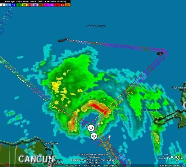
jconsor wrote:Latest dropsonde reported 978 mb again, but the winds aloft were 15-20 kt (as opposed to 5-10 kt on the previous dropsonde) so it may not have quite hit the center.cycloneye wrote:After that last dropsonde what is the real lowest pressure?
Yeah looks like its a little lower with regards to actual pressure. Next 12-18hrs are probably where we are going to see Ida peak, the jet streak looks like its going to enhance Ida but heat content starts rapidly decreasing from this point northwards.
0 likes
Personal Forecast Disclaimer:
The posts in this forum are NOT official forecast and should not be used as such. They are just the opinion of the poster and may or may not be backed by sound meteorological data. They are NOT endorsed by any professional institution or storm2k.org. For official information, please refer to the NHC and NWS products
The posts in this forum are NOT official forecast and should not be used as such. They are just the opinion of the poster and may or may not be backed by sound meteorological data. They are NOT endorsed by any professional institution or storm2k.org. For official information, please refer to the NHC and NWS products
-
CrazyC83
- Professional-Met

- Posts: 34315
- Joined: Tue Mar 07, 2006 11:57 pm
- Location: Deep South, for the first time!
Re: ATL : HURRICANE IDA
WindRunner wrote:cape_escape wrote:Hi everyone, I've been a member of S2K for about 5 years now, and have been watching the board all season. I live inCape Coral Florida, but my concern with this system is that my son is now living in Lake Charles La, and I'm not familar with that area, is there anyone on here who is near there and can tell me perhaps what county that is, or how close to the cone? he just turned 18 and has never been away from me, and has no phone available to him at the moment...any help would be appreciated!
Lake Charles is in the far southwest portion of the state. Assuming this forecast holds, he'll see more weather from the cold front going through than he will from Ida. Go to his NWS office at: http://www.srh.noaa.gov/lch/ to stay up to date on how the forecast evolves.
I don't see this being a big event for Louisiana apart from rain, since I would expect it to be quite asymmetrical at that point. There isn't even a watch for the New Orleans area (a TS Watch would be a good idea though). However, if it makes landfall, it would be more intense on the eastern side.
If that projected track holds, the worst weather should stay in the Gulf. But if it makes landfall, the coastal towns and everything south/east of the center should see very strong winds and storm surge issues.
0 likes
-
HURAKAN

- Professional-Met
- Posts: 46084
- Age: 39
- Joined: Thu May 20, 2004 4:34 pm
- Location: Key West, FL
- Contact:
879
AGXX40 KNHC 081909
MIMATS
MARINE WEATHER DISCUSSION
NWS TPC/NATIONAL HURRICANE CENTER MIAMI FL
200 PM EST SUN NOV 08 2009
MARINE WEATHER DISCUSSION FOR GULF OF MEXICO...CARIBBEAN SEA AND
SOUTHWEST NORTH ATLC S OF 31N
GULF OF MEXICO...
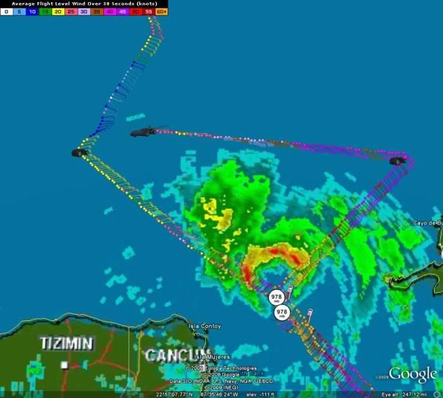
HURRICANE IDA CURRENTLY MAKING ITS WAY THROUGH THE YUCATAN
CHANNEL AND INTO THE S GULF WATERS NEAR 21.7N 86.1 AT 18 UTC. A
RECENT HURRICANE HUNTER AIRCRAFT MISSION DETERMINED THAT IDA HAS
STRENGTHENED SLIGHTLY TO 85 KT WHICH IS A MINIMAL CAT 2
HURRICANE...BUT IT IS EXPECTED TO WEAKEN BY MON NIGHT AS IT
ENCOUNTERS INCREASING SHEAR...MOVES OVER COLDER WATER...AND
MOVES INTO A COLDER AIRMASS. IDA WILL REACH NEAR 22.8N 87.1W
THIS EVENING AND THEN 25.6N 88.4W BY EARLY MON MORNING. IDA WILL
BEGIN TO INTERACT WITH AN APPROACHING COLD FRONT OVER THE
NORTHERN GULF AND THE SYSTEM IS EXPECTED TO BECOME EXTRATROPICAL
JUST PRIOR TO LANDFALL BY EARLY TUE MORNING. THE OFFICIAL NHC
TRACK TAKES IDA INTO THE CENTRAL PANHANDLE OF FL. MEANWHILE A
TIGHT PRES GRADIENT BETWEEN HIGH PRES OVER THE TROPICAL N
ATLC...IDA...AND A BROAD AREA OF LOW PRES OVER THE W GULF
CONTINUES TO RESULT IN STRONG 25-30 KT EASTERLY WINDS OVER THE
MAJORITY OF THE GULF...WITH GALE FORCE WINDS STILL OCCURRING
OVER THE SE WATERS INCLUDING THE STRAITS OF FL. C-MAN STATION
PLSF1 W-NW OF THE DRY TORTUGAS AND ALSO SAND KEY CONTINUE TO
REPORT WINDS OF 35-40 KT. SEVERAL CRUISE SHIPS N OF W CUBA ALSO
ARE REPORTING 35-40 KT WINDS. THESE WINDS WILL GRADUALLY
DIMINISH TO BELOW GALE FORCE ON MON AS IDA MOVES INTO THE N
CENTRAL GULF WITH THE PRES GRADIENT THEN WEAKENING SLIGHTLY.
STRONG NORTHERLY WINDS WILL ARRIVE BEHIND THE COLD FRONT
BEGINNING IN THE W-NW GULF AND THEN TRANSLATING TO THE E. GFS
PUSHES THE FRONT SE OF THE AREA BY WED AFTERNOON WITH 20-25 KT
WINDS CONTINUING THROUGH THU...THEN GRADUALLY DIMINISHING BY FRI
AS THE PRES GRADIENT WEAKENS.
SW N ATLC S OF 31N AND W OF 65W...
A WEAKENING COLD FRONT OVER THE FAR SE PORTION OF THE AREA FROM
22N65W TO 21N70W WILL DISSIPATE TONIGHT WITH STRONG HIGH PRES N
OF THE AREA. STRONG NE-E 20-30 KT WINDS CONTINUE ACROSS THE SW N
ATLC DUE TO COLD AIR ALOFT MOVING OVER THE WARMER OCEAN WATERS
AND THE TIGHT PRES GRADIENT BETWEEN THE HIGH AND HURCN IDA TO
THE SW-W. WINDS WILL GRADUALLY DIMINISH TUE AFTERNOON WITH THE
HIGH WEAKENING AND SHIFTING MORE TO THE NE AS A STRONG COLD
FRONT MOVES OFF THE SE U.S. COAST. SOME OF THE REMNANT ENERGY
AND MOISTURE ASSOCIATED WITH IDA MAY ALSO GET ABSORBED INTO THE
FRONT. THE FRONT WILL REACH FROM 31N77W TO 26N79.5W BY WED
AFTERNOON WITH STRONG S-SW WINDS AHEAD OF THE FRONT...AND STRONG
W-NW WINDS BEHIND IT. THE FRONT WILL SLOW DOWN OVER THE E
PORTION WITH THE STRONG WINDS CONTINUING. A NEW SET OF BUILDING
NORTHERLY LONG PERIOD SWELL ARRIVES BEHIND THE FRONT THU THROUGH
FRI.
CARIBBEAN AND TROPICAL N ATLANTIC W OF 55W...
HURCN IDA EXITING THE EXTREME NW CARIBBEAN MOVING THROUGH THE
YUCATAN CHANNEL NEAR 21.7N 86.1 AT 18 UTC. THE HURRICANE WARNING
REMAINS IN EFFECT N OF 19N W OF 83W THROUGH THIS EVENING ON THE
BACK SIDE OF THE CIRCULATION. WINDS WILL DIMINISH LATE THIS
EVENING THROUGH MON AS THE SYSTEM SPEEDS UP AND MOVES INTO THE N
CENTRAL GULF. OTHER THAN IDA...THE PRES GRADIENT REMAINS WEAK
ACROSS MOST OF THE CARIBBEAN WITH LIGHT TO MODERATE TRADES
CONTINUING THROUGH FRI. LATEST RUN OF THE GFS PUSHES A COLD
FRONT THROUGH A PORTION OF THE NW CARIBBEAN WED NIGHT INTO
THU...STALLING OUT NEAR JAMAICA THU NIGHT INTO FRI. NORTHERLY
WINDS BEHIND THE FRONT WILL INCREASE TO 20-25 KT...IF THE FRONT
MANAGES TO MAKE IT THAT FAR TO THE E-SE.
WARNINGS...
ATLC...
.NONE.
CARIBBEAN...
.AMZ082...HURRICANE WARNING N OF 19N W OF 83W THROUGH THIS
EVENING...
GULF OF MEXICO...
.GMZ084...HURRICANE WARNING THROUGH TUE MORNING.
.GMZ080...TROPICAL STORM WARNING N OF 25N E OF 91W MON THROUGH
MON NIGHT.
.GMZ086...TROPICAL STORM WARNING S OF 25N W OF 84W THROUGH TUE.
.GMZ086...GALE WARNING THROUGH TONIGHT.
.GMZ084...GALE CONDITIONS EXPECTED N OF 28N E OF 88W TUE.
.GMZ086...GALE CONDITIONS EXPECTED N OF 29N W TUE NIGHT AND WED.
$$
FORECASTER LEWITSKY
0 likes
-
cycloneye

- Admin

- Posts: 149227
- Age: 69
- Joined: Thu Oct 10, 2002 10:54 am
- Location: San Juan, Puerto Rico
Re: ATL : HURRICANE IDA - Models
Here are all the global models with their 12z runs and the 18z bams.The entretaining UKMET is the blue line.

0 likes
Visit the Caribbean-Central America Weather Thread where you can find at first post web cams,radars
and observations from Caribbean basin members Click Here
and observations from Caribbean basin members Click Here
-
cape_escape

- Category 2

- Posts: 745
- Age: 57
- Joined: Fri Aug 13, 2004 2:39 am
- Location: Cape Coral Florida
- Contact:
Re: ATL : HURRICANE IDA
WindRunner wrote:cape_escape wrote:Hi everyone, I've been a member of S2K for about 5 years now, and have been watching the board all season. I live inCape Coral Florida, but my concern with this system is that my son is now living in Lake Charles La, and I'm not familar with that area, is there anyone on here who is near there and can tell me perhaps what county that is, or how close to the cone? he just turned 18 and has never been away from me, and has no phone available to him at the moment...any help would be appreciated!
Lake Charles is in the far southwest portion of the state. Assuming this forecast holds, he'll see more weather from the cold front going through than he will from Ida. Go to his NWS office at: http://www.srh.noaa.gov/lch/ to stay up to date on how the forecast evolves.
Thank you! This is very helpful!
0 likes
-
brunota2003

- S2K Supporter

- Posts: 9476
- Age: 35
- Joined: Sat Jul 30, 2005 9:56 pm
- Location: Stanton, KY...formerly Havelock, NC
- Contact:
Re: ATL : HURRICANE IDA
CrazyC83 wrote:WindRunner wrote:cape_escape wrote:Hi everyone, I've been a member of S2K for about 5 years now, and have been watching the board all season. I live inCape Coral Florida, but my concern with this system is that my son is now living in Lake Charles La, and I'm not familar with that area, is there anyone on here who is near there and can tell me perhaps what county that is, or how close to the cone? he just turned 18 and has never been away from me, and has no phone available to him at the moment...any help would be appreciated!
Lake Charles is in the far southwest portion of the state. Assuming this forecast holds, he'll see more weather from the cold front going through than he will from Ida. Go to his NWS office at: http://www.srh.noaa.gov/lch/ to stay up to date on how the forecast evolves.
I don't see this being a big event for Louisiana apart from rain, since I would expect it to be quite asymmetrical at that point. There isn't even a watch for the New Orleans area (a TS Watch would be a good idea though). However, if it makes landfall, it would be more intense on the eastern side.
If that projected track holds, the worst weather should stay in the Gulf. But if it makes landfall, the coastal towns and everything south/east of the center should see very strong winds and storm surge issues.
Usually, yes...but it could very well have a tighter gradient to the NW of the system than to the east, due to the approaching cold front.
0 likes
Havwe to admit whilst being a little too strong the GFDL has done a very impressive job with this system IMO, still need to see how the really important part of the forecast occurs.
0 likes
Personal Forecast Disclaimer:
The posts in this forum are NOT official forecast and should not be used as such. They are just the opinion of the poster and may or may not be backed by sound meteorological data. They are NOT endorsed by any professional institution or storm2k.org. For official information, please refer to the NHC and NWS products
The posts in this forum are NOT official forecast and should not be used as such. They are just the opinion of the poster and may or may not be backed by sound meteorological data. They are NOT endorsed by any professional institution or storm2k.org. For official information, please refer to the NHC and NWS products
-
Dave

- Retired Staff

- Posts: 13442
- Age: 75
- Joined: Tue Aug 01, 2006 3:57 pm
- Location: Milan Indiana
- Contact:
URNT15 KNHC 081911
AF309 0411A IDA HDOB 28 20091108
190330 2311N 08551W 6963 03152 0077 +070 +038 115040 040 047 003 00
190400 2311N 08553W 6961 03155 0074 +071 +036 116040 040 048 003 00
190430 2311N 08556W 6959 03155 0082 +066 +035 109039 040 047 003 00
190500 2312N 08558W 6963 03150 0095 +055 +033 109035 036 047 006 00
190530 2312N 08600W 6960 03154 0087 +061 +031 107034 036 046 006 00
190600 2312N 08603W 6960 03154 0082 +064 +029 104037 038 048 007 00
190630 2312N 08605W 6958 03157 0072 +073 +028 101038 038 048 006 00
190700 2312N 08607W 6959 03158 0070 +076 +027 109036 036 046 006 00
190730 2313N 08610W 6961 03154 0072 +075 +027 111035 036 046 005 00
190800 2313N 08612W 6961 03157 0064 +080 +027 110033 034 046 004 00
190830 2313N 08614W 6961 03154 0056 +084 +028 110033 034 046 002 00
190900 2313N 08617W 6959 03155 0056 +084 +029 111032 033 046 002 00
190930 2313N 08619W 6960 03151 0059 +080 +031 111031 031 045 002 00
191000 2314N 08621W 6961 03148 0065 +077 +033 111032 032 043 003 00
191030 2314N 08623W 6956 03159 0065 +076 +034 108031 032 044 005 00
191100 2314N 08626W 6957 03154 0068 +075 +034 104034 034 044 004 00
191130 2314N 08628W 6963 03151 0068 +075 +035 100036 036 042 001 00
191200 2314N 08630W 6966 03146 0069 +075 +036 102036 037 040 001 00
191230 2315N 08633W 6947 03170 0057 +082 +038 100030 030 041 000 00
191300 2315N 08635W 6961 03150 0056 +084 +040 096031 031 040 000 00
$$
;
0 likes
-
Sabanic

- Category 2
- Posts: 683
- Age: 66
- Joined: Wed Aug 01, 2007 7:01 am
- Location: Mobile, AL
- Contact:
Re: ATL : HURRICANE IDA
Speed will be the determining factor on exactly where she makes landfall. Per the NHC track right now looks like she will go make a visit to Gulf shores, ride the coast a bit, and go Inland around Pens - Ft Walton Beach.
0 likes
"I can do all things through Christ which strengtheneth me" - Philippians 4:13
-
jconsor
- Professional-Met
- Posts: 578
- Joined: Mon Jun 30, 2008 9:31 pm
- Location: Jerusalem, Israel
- Contact:
Re: ATL : HURRICANE IDA - Models
Latest ECMWF continues to keep the northern and southern streams separate which causes the remnants of Ida to turn east across northern FL/southern GA then south toward the Bahamas. This creates several days of gale-force winds from NE FL to the VA Capes.
The ECMWF has been rather inconsistent, with most runs showing no phasing between the northern and southern streams, but a few runs (including today's 00z run) showing phasing. The overall trend of the ECMWF and other models has been toward a weaker northern stream and a stronger and slower southern stream, which does favor a cutoff low forming and absorbing Ida's remnants.
In the very long range the ECMWF develops a massive cutoff low and nor'easter by early next week which ingests Ida's remnant energy and moisture.
Last edited by jconsor on Sun Nov 08, 2009 2:24 pm, edited 1 time in total.
0 likes
Re:
deltadog03 wrote:here is the 300mb chart right now! This is why I called for a higher storm at landfall....Look at the jetstreak coming in!! VERY VERY FAVORABLE for outflow and upper DIV.

I think this is a extremely imporant point which we need to stay tuned to......I remember (i think!) in a post wilma discussion .....this being mentioned as a reason why she was able to strengthen and then maintain such strength even thou she was supposed to be in a moderate shear enviornement prior to hitting S FL
0 likes
Re: ATL : HURRICANE IDA - Models
What is Euro showing for strength on the NGOM. Where does Euro call the "landfall" of whatever the system is when it reaches the coast.
0 likes

Re: ATL : HURRICANE IDA - Models
Rainband wrote:i dont like that loopcycloneye wrote:Ivan,look at this loop that 12z UKMET has.
http://moe.met.fsu.edu/cgi-bin/ukmtc2.c ... =Animation
jeeesh, with that loop all but the southern tip of Florida is in play and some areas twice! lol
0 likes
-
CrazyC83
- Professional-Met
- Posts: 34315
- Joined: Tue Mar 07, 2006 11:57 pm
- Location: Deep South, for the first time!
Re: ATL : HURRICANE IDA
Sabanic wrote:Speed will be the determining factor on exactly where she makes landfall. Per the NHC track right now looks like she will go make a visit to Gulf shores, ride the coast a bit, and go Inland around Pens - Ft Walton Beach.
Speed would also determine the intensity/formation of the system. If it picks up speed, it could certainly make landfall as a solid, full-fledged hurricane as it would spend much less time over the cooler waters. If it stays at the current pace, it has a better chance of either weakening or becoming extratropical (but still hurricane-strength in that case).
If it becomes extratropical while still at hurricane intensity, what watches/warnings would be issued?
0 likes
-
Dave
- Retired Staff
- Posts: 13442
- Age: 75
- Joined: Tue Aug 01, 2006 3:57 pm
- Location: Milan Indiana
- Contact:
URNT15 KNHC 081921
AF309 0411A IDA HDOB 29 20091108
191330 2315N 08638W 6962 03151 0054 +085 +042 095030 030 040 000 00
191400 2315N 08640W 6961 03151 0064 +078 +045 094031 032 039 000 00
191430 2315N 08642W 6962 03150 0065 +077 +047 092032 033 039 000 00
191500 2316N 08645W 6959 03156 0067 +075 +049 092028 029 040 001 00
191530 2316N 08647W 6961 03158 0067 +079 +049 091025 026 040 001 00
191600 2316N 08650W 6959 03153 0059 +080 +050 094025 027 040 000 00
191630 2316N 08652W 6962 03151 0059 +080 +050 086029 030 037 000 00
191700 2317N 08654W 6958 03155 0061 +079 +050 086030 030 037 000 00
191730 2317N 08657W 6961 03152 0063 +077 +051 087028 030 037 001 00
191800 2317N 08659W 6962 03151 0064 +077 +051 087026 026 036 000 00
191830 2317N 08701W 6959 03156 0065 +077 +052 085023 025 036 000 00
191900 2317N 08704W 6961 03152 0062 +080 +053 087022 023 036 000 00
191930 2318N 08706W 6962 03153 0065 +075 +053 090024 025 036 000 00
192000 2318N 08709W 6958 03158 0067 +076 +053 088026 026 036 000 00
192030 2318N 08711W 6961 03152 0061 +081 +053 086026 027 037 000 00
192100 2318N 08713W 6961 03157 0063 +079 +053 084027 027 036 000 00
192130 2318N 08716W 6960 03155 0068 +075 +054 085027 028 035 000 00
192200 2319N 08718W 6959 03159 0069 +075 +054 083029 029 033 000 00
192230 2319N 08720W 6963 03152 0068 +075 +053 084030 030 033 001 00
192300 2319N 08723W 6960 03158 0066 +078 +053 084027 028 032 000 00
$$
;
0 likes
-
Aric Dunn
- Category 5

- Posts: 21238
- Age: 43
- Joined: Sun Sep 19, 2004 9:58 pm
- Location: Ready for the Chase.
- Contact:
Do not expect a transition until the shear increases ( if it all since its still decreasing) cause if convection maintains around the center then we have convergence around the center and thus a temperature and pressure gradient and in turn a tropical system. the shear must come and expose the center.
0 likes
Who is online
Users browsing this forum: No registered users and 5 guests