
ATL: MARIA - Post-Tropical - Discussion
Moderator: S2k Moderators
Re: ATL: MARIA - Hurricane - Discussion
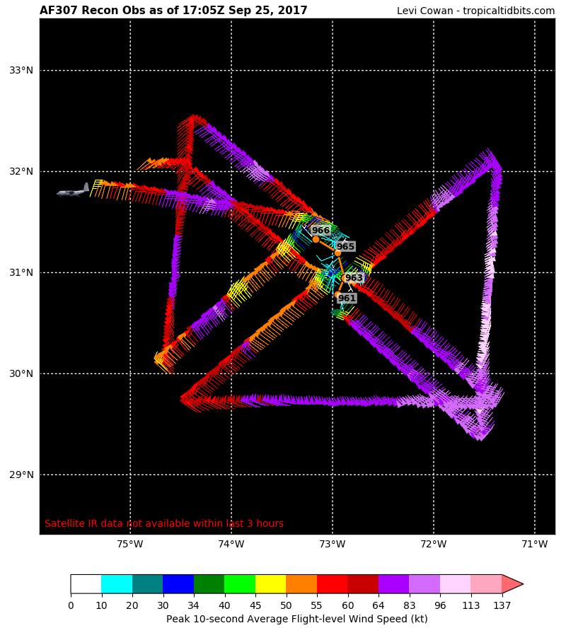
This is from a few hours ago. Recon is back in now and found the pressure back down to 961. They also just found 75kt surface winds. Still a hurricane.
1 likes
-
wxman57

- Moderator-Pro Met

- Posts: 23175
- Age: 68
- Joined: Sat Jun 21, 2003 8:06 pm
- Location: Houston, TX (southwest)
Re: ATL: MARIA - Hurricane - Discussion
There was talk that Maria is now moving NW. Don't assume that recon reported the exact center of the very large eye each pass. Looking at a 3-hr loop on satellite, I calculate a movement toward 049 deg (NE) at about 4-5 kts. Previous 3 hours, I get 317 deg (NW) at 8 kts. Maria was moving NW between 1345Z and 1645Z. Since then, it slowed and turned NE. Probably observing wobbles left and right.
2 likes
-
wxman57
- Moderator-Pro Met
- Posts: 23175
- Age: 68
- Joined: Sat Jun 21, 2003 8:06 pm
- Location: Houston, TX (southwest)
Re: ATL: MARIA - Hurricane - Discussion
From San Juan Weather office, here's the status of the radar:
000
NOUS62 TJSJ 251947
FTMJUA
MESSAGE DATE: SEP 25 2017 19:47:00
TJUA (NEXRAD IN CAYEY, PR) WAS ABUSED BY MARIA. AS A RESULT THE
RADOME DIVORCED THE TOWER AND RAN AWAY WITH ONE DEPENDENT, THE
ANTENNA. RECONCILIATION WILL HOPEFULLY BE COMPLETED IN 3 TO 6
MONTHS. MARIA FLED THE SCENE HEADING NORTHWEST. SHE IS CONSIDERED
ARMED AND DANGEROUS--DO NOT ATTEMPT TO APPREHEND.
17 likes
-
WeatherGuesser
- Category 5

- Posts: 2672
- Joined: Tue Jun 29, 2010 6:46 am
Re: ATL: MARIA - Hurricane - Discussion
Radar on GR3 appears to be suspended in time at the moment of the offense.
TSJU appears to have gone walkabout too.
TSJU appears to have gone walkabout too.
0 likes
-
EquusStorm
- Category 5
- Posts: 1649
- Age: 35
- Joined: Thu Nov 07, 2013 1:04 pm
- Location: Jasper, AL
- Contact:
Re: ATL: MARIA - Hurricane - Discussion
Near 38.5 ACE currently. Can she break 40 and hold it on the best track before going post-tropical? Maybe! Kinda hoping for more records while we're at it 
3 likes
Colors of lost purpose on the canvas of irrelevance
Not a meteorologist, in fact more of an idiot than anything. You should probably check with the NHC or a local NWS office for official information.
Not a meteorologist, in fact more of an idiot than anything. You should probably check with the NHC or a local NWS office for official information.
-
1900hurricane

- Category 5
- Posts: 6063
- Age: 34
- Joined: Fri Feb 06, 2015 12:04 pm
- Location: Houston, TX
- Contact:
Re: ATL: MARIA - Hurricane - Discussion
EquusStorm wrote:Near 38.5 ACE currently. Can she break 40 and hold it on the best track before going post-tropical? Maybe! Kinda hoping for more records while we're at it
I think we'll make it. 70 kt is 0.49 ACE every six hours or about 2 ACE/day. There's obviously going to be some weakening, but unless Maria completes extratropical transition considerably earlier than currently predicted, 40 ACE will be obtained. It's worth noting that no satellite era NAtl season has ever had three or more individual systems break 40 ACE (not sure about pre-satellite era). Additionally only 3 WPac seasons have done so since 1970. 1997 (most active on record) had six(!) and 2004 and 1992 (second and third most active, respectively) each had three apiece.
3 likes
Contract Meteorologist. TAMU & MSST. Fiercely authentic, one of a kind. We are all given free will, so choose a life meant to be lived. We are the Masters of our own Stories.
Opinions expressed are mine alone.
Follow me on Twitter at @1900hurricane : Read blogs at https://1900hurricane.wordpress.com/
Opinions expressed are mine alone.
Follow me on Twitter at @1900hurricane : Read blogs at https://1900hurricane.wordpress.com/
-
1900hurricane
- Category 5
- Posts: 6063
- Age: 34
- Joined: Fri Feb 06, 2015 12:04 pm
- Location: Houston, TX
- Contact:
Re: ATL: MARIA - Hurricane - Discussion
Funky.

1 likes
Contract Meteorologist. TAMU & MSST. Fiercely authentic, one of a kind. We are all given free will, so choose a life meant to be lived. We are the Masters of our own Stories.
Opinions expressed are mine alone.
Follow me on Twitter at @1900hurricane : Read blogs at https://1900hurricane.wordpress.com/
Opinions expressed are mine alone.
Follow me on Twitter at @1900hurricane : Read blogs at https://1900hurricane.wordpress.com/
-
emeraldislenc
- Category 2

- Posts: 602
- Joined: Fri Aug 24, 2012 4:49 pm
- Location: Emerald Isle NC
-
CrazyC83
- Professional-Met

- Posts: 34316
- Joined: Tue Mar 07, 2006 11:57 pm
- Location: Deep South, for the first time!
Re: ATL: MARIA - Hurricane - Discussion
Maria still seems to be moving almost due north.
I wonder if the filling has adjusted the steering currents at all?
I wonder if the filling has adjusted the steering currents at all?
0 likes
-
Digital-TC-Chaser


Re: ATL: MARIA - Hurricane - Discussion

Outer bands starting to move in.
0 likes
The above post is not official and should not be used as such. It is the opinion of the poster and may or may not be backed by sound meteorological data. It is not endorsed by any professional institution or storm2k.org. For official information, please refer to the NHC and NWS products.
-
wxman57
- Moderator-Pro Met
- Posts: 23175
- Age: 68
- Joined: Sat Jun 21, 2003 8:06 pm
- Location: Houston, TX (southwest)
Re: ATL: MARIA - Hurricane - Discussion
No 64kt winds on the first two passes through the center by recon this morning. Max I saw was about 62kts, which would be enough to keep it a hurricane on the next advisory. Doesn't look like much of an impact across the Outer Banks next 24hrs. NE winds 25-35 mph in general, with occasional showers. Might see a report or two of 40 mph winds. No heavy squalls, though.
3 likes
-
CrazyC83
- Professional-Met
- Posts: 34316
- Joined: Tue Mar 07, 2006 11:57 pm
- Location: Deep South, for the first time!
Re: ATL: MARIA - Hurricane - Discussion
I wonder - once Maria makes the easterly turn, breaking free of Jose's wake, could it get one more chance to restrengthen? Especially if it turns at a fairly low latitude.
0 likes
-
EquusStorm
- Category 5
- Posts: 1649
- Age: 35
- Joined: Thu Nov 07, 2013 1:04 pm
- Location: Jasper, AL
- Contact:
Re: ATL: MARIA - Hurricane - Discussion
I'm still surprised that Jose's wake was so significant. One would think it'd have recovered slightly, especially over the Gulf Stream. Imagine how different a storm we'd be looking at if it had tracked west of the wake.
0 likes
Colors of lost purpose on the canvas of irrelevance
Not a meteorologist, in fact more of an idiot than anything. You should probably check with the NHC or a local NWS office for official information.
Not a meteorologist, in fact more of an idiot than anything. You should probably check with the NHC or a local NWS office for official information.
-
emeraldislenc
- Category 2
- Posts: 602
- Joined: Fri Aug 24, 2012 4:49 pm
- Location: Emerald Isle NC
Re: ATL: MARIA - Hurricane - Discussion
If she had tracked more west it would have been a different situation. The sun is now out here.
0 likes
-
txwatcher91
- Category 5
- Posts: 1498
- Joined: Tue Aug 02, 2005 2:29 pm
Re: ATL: MARIA - Hurricane - Discussion
wxman57 wrote:No 64kt winds on the first two passes through the center by recon this morning. Max I saw was about 62kts, which would be enough to keep it a hurricane on the next advisory. Doesn't look like much of an impact across the Outer Banks next 24hrs. NE winds 25-35 mph in general, with occasional showers. Might see a report or two of 40 mph winds. No heavy squalls, though.
The issue here isn't the wind but the surge in the sounds. The OBX sound side is now under a surge warning with 2-4 feet of inundation across the area and 15-25 foot waves on the ocean side that will cause heavy erosion. The wind and rain impact will be minimal but the surge and erosion will cause issues for a lot of businesses and residents in the area.
0 likes
-
WeatherGuesser
- Category 5
- Posts: 2672
- Joined: Tue Jun 29, 2010 6:46 am
-
wxman57
- Moderator-Pro Met
- Posts: 23175
- Age: 68
- Joined: Sat Jun 21, 2003 8:06 pm
- Location: Houston, TX (southwest)
Re: ATL: MARIA - Hurricane - Discussion
txwatcher91 wrote:wxman57 wrote:No 64kt winds on the first two passes through the center by recon this morning. Max I saw was about 62kts, which would be enough to keep it a hurricane on the next advisory. Doesn't look like much of an impact across the Outer Banks next 24hrs. NE winds 25-35 mph in general, with occasional showers. Might see a report or two of 40 mph winds. No heavy squalls, though.
The issue here isn't the wind but the surge in the sounds. The OBX sound side is now under a surge warning with 2-4 feet of inundation across the area and 15-25 foot waves on the ocean side that will cause heavy erosion. The wind and rain impact will be minimal but the surge and erosion will cause issues for a lot of businesses and residents in the area.
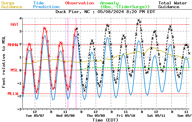
The tides may be closer to 2 ft above normal than 4 ft, so 2-3 ft would be more accurate. Forecast for Duck Pier (northern Outer Banks) is for tides a little over 2 ft above normal next day or two. This is due to the large waves moving into the coast. Highest projections I can find are about 2.5 ft above normal. Still, tides a couple of feet above normal for such a flat area is a problem.
0 likes
-
txwatcher91
- Category 5
- Posts: 1498
- Joined: Tue Aug 02, 2005 2:29 pm
Re: ATL: MARIA - Hurricane - Discussion
wxman57 wrote:txwatcher91 wrote:wxman57 wrote:No 64kt winds on the first two passes through the center by recon this morning. Max I saw was about 62kts, which would be enough to keep it a hurricane on the next advisory. Doesn't look like much of an impact across the Outer Banks next 24hrs. NE winds 25-35 mph in general, with occasional showers. Might see a report or two of 40 mph winds. No heavy squalls, though.
The issue here isn't the wind but the surge in the sounds. The OBX sound side is now under a surge warning with 2-4 feet of inundation across the area and 15-25 foot waves on the ocean side that will cause heavy erosion. The wind and rain impact will be minimal but the surge and erosion will cause issues for a lot of businesses and residents in the area.
The tides may be closer to 2 ft above normal than 4 ft, so 2-3 ft would be more accurate. Forecast for Duck Pier (northern Outer Banks) is for tides a little over 2 ft above normal next day or two. This is due to the large waves moving into the coast. Highest projections I can find are about 2.5 ft above normal. Still, tides a couple of feet above normal for such a flat area is a problem.
[img]http://www.nws.noaa.gov/mdl/etsurge/msl/data/ncduck.gif[/mg]
From what I read in the storm surge warning, they are expecting 2-4 feet of inundation on the sound side of the OBX which will definitely cause some big problems if that verifies. Already the coast guard hydro gauge is measuring nearly 3 feet and moderate flooding begins at 3.5 feet. Cedar Island is at 2.4 feet and moderate flooding begins at 4 feet there. The duration of the winds and large area will continue to pile the waters up the next 24 hours and usually experience around this area tells me the sounds rise a bit more than forecast most of the time.
0 likes
-
WeatherGuesser
- Category 5
- Posts: 2672
- Joined: Tue Jun 29, 2010 6:46 am
Re: ATL: MARIA - Hurricane - Discussion
Somebody call for an evacuation of this thread?
Hello?
Hello?
0 likes
Who is online
Users browsing this forum: No registered users and 67 guests