ATL: Tropical Storm Kyle : Discussion
Moderator: S2k Moderators
Re: ATL: INVEST 93L - Discussion
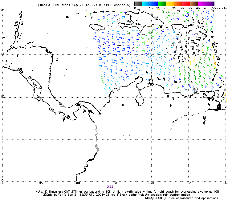
Quikscat definitely looks like there is something going on, but probably not closed
0 likes


-
cycloneye

- Admin

- Posts: 149556
- Age: 69
- Joined: Thu Oct 10, 2002 10:54 am
- Location: San Juan, Puerto Rico
Re: ATL: INVEST 93L - Discussion
BULLETIN - EAS ACTIVATION REQUESTED
FLASH FLOOD WARNING
NATIONAL WEATHER SERVICE SAN JUAN PR
922 AM AST SUN SEP 21 2008
THE NATIONAL WEATHER SERVICE IN SAN JUAN HAS ISSUED A
* FLASH FLOOD WARNING FOR...
THE FOLLOWING MUNICIPALITIES
IN PUERTO RICO
JUNCOS
LAS PIEDRAS
LUQUILLO
NAGUABO
CEIBA
CANOVANAS
FAJARDO
RIO GRANDE
* UNTIL 12:15 PM AST
* AT 9:15 AM AST...NWS DOPPLER RADAR SHOWED ANOTHER BAND OF SHOWERS
AND THUNDERSTORMS MOVING IN ACROSS THE FAJARDO AREA AND SHIFTING
WESTWARD INTO LUQUILLO AND RIO GRANDE...PRODUCING HEAVY RAINFALL.
RAINFALL ACCUMULATIONS OF AROUND TWO INCHES HAVE OCCURRED IN THE
PAST HOUR...AND LOCAL RIVERS AND STREAMS ARE RESPONDING WITH RAPID
RISES.
EXCESSIVE RUNOFF FROM HEAVY RAINFALL WILL CAUSE FLOODING OF SMALL
CREEKS AND STREAMS...HIGHWAYS AND UNDERPASSES. ADDITIONALLY...ROADS
AND LANDS ALONG THE BANKS OF CREEKS...STREAMS AND OTHER LOW LYING
AREAS ARE SUBJECT TO FLOODING.
A FLASH FLOOD WARNING MEANS THAT FLOODING IS IMMINENT OR OCCURRING.
IF YOU ARE IN THE WARNING AREA MOVE TO HIGHER GROUND IMMEDIATELY.
RESIDENTS LIVING ALONG STREAMS AND CREEKS SHOULD TAKE IMMEDIATE
PRECAUTIONS TO PROTECT LIFE AND PROPERTY. DO NOT ATTEMPT TO CROSS
SWIFTLY FLOWING WATERS OR WATERS OF UNKNOWN DEPTH BY FOOT OR BY
AUTOMOBILE.
LAT...LON 1827 6575 1823 6589 1843 6583 1838 6561
1821 6561 1818 6573
$$
0 likes
-
HurricaneFreak
Re: ATL: INVEST 93L - Discussion
Ha I knew it was going to be a code red today and it should be a depression today because look how organized it got overnight it looks like its starting to get good circulation and outflow.Lyons just said the low is not actually west of the convection but he did say there is a circulaton there but the actual low is in the middle of the deep conection 100miles southeast of PR.
0 likes
-
HurricaneFreak
Re: ATL: INVEST 93L - Discussion
Fellows I wouldn't take these first computer models because they have not considered it a depression yet.And when it does become a depression or tropical storm the computer models always change like with Ike it had it pointing towards Florida but then south of Florida so Florida is not out of the clear yet.
0 likes
-
jlauderdal
- S2K Supporter

- Posts: 7240
- Joined: Wed May 19, 2004 5:46 am
- Location: NE Fort Lauderdale
- Contact:
Re: ATL: INVEST 93L - Discussion
HurricaneFreak wrote:Ha I knew it was going to be a code red today and it should be a depression today because look how organized it got overnight it looks like its starting to get good circulation and outflow.Lyons just said the low is not actually west of the convection but he did say there is a circulaton there but the actual low is in the middle of the deep conection 100miles southeast of PR.
hey, i think i saw this same info in another thread, like the models thread that is going on this invest
0 likes
-
Evil Jeremy

- S2K Supporter
- Posts: 5463
- Age: 32
- Joined: Mon Apr 10, 2006 2:10 pm
- Location: Los Angeles, CA
Re: ATL: INVEST 93L - Discussion
HurricaneFreak wrote:Fellows I wouldn't take these first computer models because they have not considered it a depression yet.And when it does become a depression or tropical storm the computer models always change like with Ike it had it pointing towards Florida but then south of Florida so Florida is not out of the clear yet.
A little -removed-, eh? I am not worried at all about this. It is likely going to shoot north and affect Puerto Rico and the Bahamas. After that, it should either shoot out to sea, or move back towards the US East Coast.
0 likes
-
jlauderdal
- S2K Supporter
- Posts: 7240
- Joined: Wed May 19, 2004 5:46 am
- Location: NE Fort Lauderdale
- Contact:
Re: ATL: INVEST 93L - Discussion
HurricaneFreak wrote:Ha I knew it was going to be a code red today and it should be a depression today because look how organized it got overnight it looks like its starting to get good circulation and outflow.Lyons just said the low is not actually west of the convection but he did say there is a circulaton there but the actual low is in the middle of the deep conection 100miles southeast of PR.
did the good doctor bless the viewers with a track prediction or will that require tuning in next hour? I dont watch TWC so I will have to rely on our esteemed board members to keep me updated as to the info on TWC
0 likes
-
wzrgirl1

- S2K Supporter
- Posts: 1360
- Joined: Sat Sep 04, 2004 6:44 am
- Location: Pembroke Pines, Florida
Re: ATL: INVEST 93L - Discussion
I don't believe the models can be totally taken into consideration because at the time the system did not have a closed surface low (not sure if it does now either)....but looking better according to quickskat. However, there is a forecasted trough expected to sweep down in the next few days so we should be open to all possibilities until we can get a better read from recon later this afternoon. Stay tuned......could get interesting.
0 likes
-
Cryomaniac
- Category 5

- Posts: 1289
- Joined: Tue Aug 15, 2006 2:26 pm
- Location: Newark, Nottinghamshire, UK
- Contact:
-
'CaneFreak

- Category 5
- Posts: 1487
- Joined: Mon Jun 05, 2006 10:50 am
- Location: New Bern, NC
000
WONT41 KNHC 211432
DSAAT
SPECIAL TROPICAL DISTURBANCE STATEMENT
NWS TPC/NATIONAL HURRICANE CENTER MIAMI FL
1030 AM EDT SUN SEP 21 2008
SATELLITE IMAGERY...SURFACE OBSERVATIONS...AND NOAA DOPPLER WEATHER
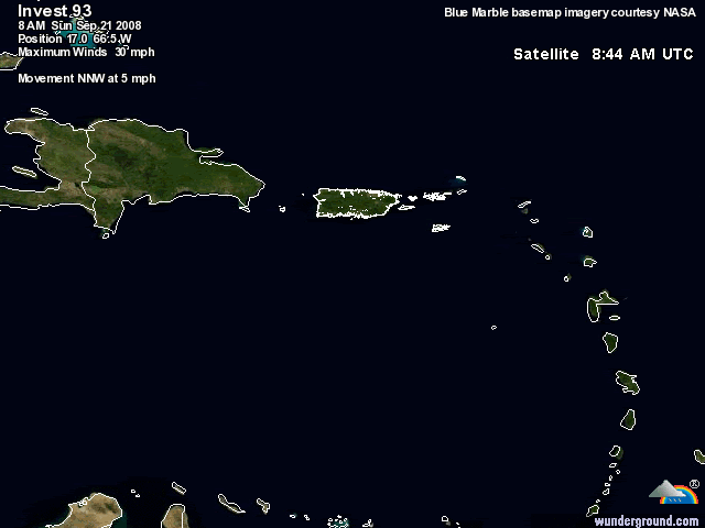
RADAR DATA FROM SAN JUAN PUERTO RICO INDICATE THE LOW PRESSURE AREA
LOCATED ABOUT 70 MILES SOUTH OF PUERTO RICO HAS CONTINUED TO BECOME
BETTER ORGANIZED THIS MORNING. THIS SYSTEM COULD BECOME A TROPICAL
DEPRESSION AT ANY TIME AS IT MOVES SLOWLY NORTH-NORTHWESTWARD OR
NORTHWARD AT ABOUT 5 MPH. AN AIR FORCE RESERVE RECONNAISSANCE
AIRCRAFT IS CURRENTLY ENROUTE TO INVESTIGATE THE SYSTEM.
INTERESTS IN PUERTO RICO...THE U.S. AND BRITISH VIRGIN ISLANDS...AND
EASTERN HISPANIOLA SHOULD MONITOR THE PROGRESS OF THIS SYSTEM AND
ANY PRODUCTS ISSUED BY THE RESPECTIVE WEATHER FORECAST OFFICES.
$$
FORECASTER STEWART

HMMMMMMMMMMMMMMMMMMMMMMMMM
WONT41 KNHC 211432
DSAAT
SPECIAL TROPICAL DISTURBANCE STATEMENT
NWS TPC/NATIONAL HURRICANE CENTER MIAMI FL
1030 AM EDT SUN SEP 21 2008
SATELLITE IMAGERY...SURFACE OBSERVATIONS...AND NOAA DOPPLER WEATHER
RADAR DATA FROM SAN JUAN PUERTO RICO INDICATE THE LOW PRESSURE AREA
LOCATED ABOUT 70 MILES SOUTH OF PUERTO RICO HAS CONTINUED TO BECOME
BETTER ORGANIZED THIS MORNING. THIS SYSTEM COULD BECOME A TROPICAL
DEPRESSION AT ANY TIME AS IT MOVES SLOWLY NORTH-NORTHWESTWARD OR
NORTHWARD AT ABOUT 5 MPH. AN AIR FORCE RESERVE RECONNAISSANCE
AIRCRAFT IS CURRENTLY ENROUTE TO INVESTIGATE THE SYSTEM.
INTERESTS IN PUERTO RICO...THE U.S. AND BRITISH VIRGIN ISLANDS...AND
EASTERN HISPANIOLA SHOULD MONITOR THE PROGRESS OF THIS SYSTEM AND
ANY PRODUCTS ISSUED BY THE RESPECTIVE WEATHER FORECAST OFFICES.
$$
FORECASTER STEWART
HMMMMMMMMMMMMMMMMMMMMMMMMM
0 likes
-
cycloneye
- Admin
- Posts: 149556
- Age: 69
- Joined: Thu Oct 10, 2002 10:54 am
- Location: San Juan, Puerto Rico
Re: ATL: INVEST 93L=Special Tropical Disturbance Statement

Starting to rain where I am.I hear thunder at the distance.All points towards very wet two to three days here as this crawls northward.Lets see if its only rain or something more.
0 likes
-
HurricaneFreak
Re: ATL: INVEST 93L - Discussion
Lyons mentioned that if the storm stays weak it could move more towards the west towards east coast but if it stays strong it could be a fish storm.
0 likes

-
El Nino

- Category 1

- Posts: 454
- Age: 48
- Joined: Sun Oct 16, 2005 3:18 pm
- Location: Lima - Miraflores (Peru)
- Contact:
Re: ATL: INVEST 93L - Discussion
I don't think RECON will find a LLC. When is the next flight scheduled ?
0 likes
-
captain east

- Tropical Storm

- Posts: 213
- Joined: Thu Aug 28, 2008 2:53 pm
- Location: South East Florida
Re: ATL: INVEST 93L - Discussion
El Nino wrote:I don't think RECON will find a LLC. When is the next flight scheduled ?
tomorrow at 1PM EST
0 likes
-
wxman57

- Moderator-Pro Met

- Posts: 23175
- Age: 68
- Joined: Sat Jun 21, 2003 8:06 pm
- Location: Houston, TX (southwest)
Re: ATL: INVEST 93L - Discussion
HurricaneFreak wrote:Fellows I wouldn't take these first computer models because they have not considered it a depression yet.And when it does become a depression or tropical storm the computer models always change like with Ike it had it pointing towards Florida but then south of Florida so Florida is not out of the clear yet.
I wouldn't count on any significant change. With a deepening trof along the east coast later this week, it's not likely going to Florida. More likely it'll move north for 3-4 days then NW and be absorbed by the frontal system off the east coast late in the week.
0 likes
Who is online
Users browsing this forum: No registered users and 11 guests