
If this does become a major hurricane and hits Cuba, they will be devastated again after Gustav and Ike. Has there been another season this cruel to the Caribbean islands? (not a single TC, the season as a whole I mean).
ATL: PALOMA - Tropical Depression - Discussion
Moderator: S2k Moderators
The 2008 Atlantic hurricane season is definitely one to remember. Another Omar type monster in the making and yet again for the 3rd time now in this season a TD to Hurricane in less than 20 hours! 
If this does become a major hurricane and hits Cuba, they will be devastated again after Gustav and Ike. Has there been another season this cruel to the Caribbean islands? (not a single TC, the season as a whole I mean).
If this does become a major hurricane and hits Cuba, they will be devastated again after Gustav and Ike. Has there been another season this cruel to the Caribbean islands? (not a single TC, the season as a whole I mean).
0 likes


-
gatorcane

- S2K Supporter

- Posts: 23708
- Age: 48
- Joined: Sun Mar 13, 2005 3:54 pm
- Location: Boca Raton, FL
Re:
Cyclenall wrote:The 2008 Atlantic hurricane season is definitely one to remember. Another Omar type monster in the making and yet again for the 3rd time now in this season a TD to Hurricane in less than 20 hours!
If this does become a major hurricane and hits Cuba, they will be devastated again after Gustav and Ike. Has there been another season this cruel to the Caribbean islands? (not a single TC, the season as a whole I mean).
2008 has been one of the worst seasons in years for landfalling systems. The Caribbean has been battered by several systems some of those being major systems: Ike, Gustav, Fay and Omar.
The United States was hit by several systems some of those being majors: Dolly, Gustav, Ike, and Fay, and Hanna.
If you think about it, there were very few "fish" systems this year. The ratio of landfalling systems to developing systems may just be one of the highest ratios in quite sometime and maybe even all-time?
Anyway back on topic, Paloma looks quite impressive to say the least.

0 likes


Re: ATL: PALOMA - Hurricane - Discussion
A little bit of uncertainty in the global models this morning regarding Paloma's path - the CMC, NOGAPS & UKMET want to slow Paloma prior to approaching Cuba, weaken it, and then slowly move the remnants toward the west or northwest - eventually to be absorbed into a shortwave trough approaching the lower Mississippi valley mid-week - essentially what NOGAPs path is showing. All these models dramatically weaken Paloma due to shear. The Euro brings Paloma across Cuba into the Bahamas but then stalls it and moves it west-northwest across the S FL peninsula. The GFS does something similar to the Euro. Even the hurricane models (GFDL and HWRF) stall the weakened remains of Paloma over the eastern Bahamas. So, as of now, none of the models jet Paloma off to the NE into the open Atlantic although all of them pretty unanimously weaken Paloma after about 48 hrs.
0 likes
-
wxman57

- Moderator-Pro Met

- Posts: 23172
- Age: 68
- Joined: Sat Jun 21, 2003 8:06 pm
- Location: Houston, TX (southwest)
Re: ATL: PALOMA - Hurricane - Discussion
ronjon wrote:A little bit of uncertainty in the global models this morning regarding Paloma's path - the CMC, NOGAPS & UKMET want to slow Paloma prior to approaching Cuba, weaken it, and then slowly move the remnants toward the west or northwest - eventually to be absorbed into a shortwave trough approaching the lower Mississippi valley mid-week - essentially what NOGAPs path is showing. All these models dramatically weaken Paloma due to shear. The Euro brings Paloma across Cuba into the Bahamas but then stalls it and moves it west-northwest across the S FL peninsula. The GFS does something similar to the Euro. Even the hurricane models (GFDL and HWRF) stall the weakened remains of Paloma over the eastern Bahamas. So, as of now, none of the models jet Paloma off to the NE into the open Atlantic although all of them pretty unanimously weaken Paloma after about 48 hrs.
See my post in the models thread. There really isn't very much uncertainty in the models, just with NOGAPS. NOGAPS is almost always directly opposite all other model guidance. While all models took Gustav west south of Cuba and into the Gulf, NOGAPS took it NE across the Dominican Republic and out to sea. NOGAPS took 93L (Paloma) SW into Nicaragua initially. It doesn't have a clue.
0 likes
-
gatorcane
- S2K Supporter
- Posts: 23708
- Age: 48
- Joined: Sun Mar 13, 2005 3:54 pm
- Location: Boca Raton, FL
Re: ATL: PALOMA - Hurricane - Discussion
wxman57 wrote:ronjon wrote:A little bit of uncertainty in the global models this morning regarding Paloma's path - the CMC, NOGAPS & UKMET want to slow Paloma prior to approaching Cuba, weaken it, and then slowly move the remnants toward the west or northwest - eventually to be absorbed into a shortwave trough approaching the lower Mississippi valley mid-week - essentially what NOGAPs path is showing. All these models dramatically weaken Paloma due to shear. The Euro brings Paloma across Cuba into the Bahamas but then stalls it and moves it west-northwest across the S FL peninsula. The GFS does something similar to the Euro. Even the hurricane models (GFDL and HWRF) stall the weakened remains of Paloma over the eastern Bahamas. So, as of now, none of the models jet Paloma off to the NE into the open Atlantic although all of them pretty unanimously weaken Paloma after about 48 hrs.
See my post in the models thread. There really isn't very much uncertainty in the models, just with NOGAPS. NOGAPS is almost always directly opposite all other model guidance. While all models took Gustav west south of Cuba and into the Gulf, NOGAPS took it NE across the Dominican Republic and out to sea. NOGAPS took 93L (Paloma) SW into Nicaragua initially. It doesn't have a clue.
Ronjon and all -- Just to reiterate what we've been saying: this is not a Florida system.. There will be 60-80K of shear behind the front pulverizing whatever is left of Paloma even if she decided to retrograge back west.
Should be a good Golf day across South Florida on both Sat. and Sun., some high cirrus passing by at times from Paloma's outflow but generally fresh Easterly to Northeasterly breezes between 10-15mph becoming Northerly behind the front between 15-20mph with some higher gusts.
0 likes
-
DESTRUCTION5

- Category 5

- Posts: 4430
- Age: 44
- Joined: Wed Sep 03, 2003 11:25 am
- Location: Stuart, FL
Re: ATL: PALOMA - Hurricane - Discussion
gatorcane wrote:wxman57 wrote:ronjon wrote:A little bit of uncertainty in the global models this morning regarding Paloma's path - the CMC, NOGAPS & UKMET want to slow Paloma prior to approaching Cuba, weaken it, and then slowly move the remnants toward the west or northwest - eventually to be absorbed into a shortwave trough approaching the lower Mississippi valley mid-week - essentially what NOGAPs path is showing. All these models dramatically weaken Paloma due to shear. The Euro brings Paloma across Cuba into the Bahamas but then stalls it and moves it west-northwest across the S FL peninsula. The GFS does something similar to the Euro. Even the hurricane models (GFDL and HWRF) stall the weakened remains of Paloma over the eastern Bahamas. So, as of now, none of the models jet Paloma off to the NE into the open Atlantic although all of them pretty unanimously weaken Paloma after about 48 hrs.
See my post in the models thread. There really isn't very much uncertainty in the models, just with NOGAPS. NOGAPS is almost always directly opposite all other model guidance. While all models took Gustav west south of Cuba and into the Gulf, NOGAPS took it NE across the Dominican Republic and out to sea. NOGAPS took 93L (Paloma) SW into Nicaragua initially. It doesn't have a clue.
Ronjon and all -- Just to reiterate what we've been saying: this is not a Florida system.
Should be a good Golf day across South Florida on both Sat. and Sun., some high cirrus passing by at times from Paloma's outflow but generally fresh Easterly to Northeasterly breezes between 10-15mph becoming Northerly behind the front between 15-20mph with some higher gusts.
I think thats fairly obvious...I think what everyone is looking at here is does it stall in the bahamas and try to come back a swirl...or very weak system...
0 likes
Re: ATL: PALOMA - Hurricane - Discussion
gatorcane wrote:wxman57 wrote:ronjon wrote:A little bit of uncertainty in the global models this morning regarding Paloma's path - the CMC, NOGAPS & UKMET want to slow Paloma prior to approaching Cuba, weaken it, and then slowly move the remnants toward the west or northwest - eventually to be absorbed into a shortwave trough approaching the lower Mississippi valley mid-week - essentially what NOGAPs path is showing. All these models dramatically weaken Paloma due to shear. The Euro brings Paloma across Cuba into the Bahamas but then stalls it and moves it west-northwest across the S FL peninsula. The GFS does something similar to the Euro. Even the hurricane models (GFDL and HWRF) stall the weakened remains of Paloma over the eastern Bahamas. So, as of now, none of the models jet Paloma off to the NE into the open Atlantic although all of them pretty unanimously weaken Paloma after about 48 hrs.
See my post in the models thread. There really isn't very much uncertainty in the models, just with NOGAPS. NOGAPS is almost always directly opposite all other model guidance. While all models took Gustav west south of Cuba and into the Gulf, NOGAPS took it NE across the Dominican Republic and out to sea. NOGAPS took 93L (Paloma) SW into Nicaragua initially. It doesn't have a clue.
Ronjon and all -- Just to reiterate what we've been saying: this is not a Florida system.
Should be a good Golf day across South Florida on both Sat. and Sun., some high cirrus passing by at times from Paloma's outflow but generally fresh Easterly to Northeasterly breezes between 10-15mph becoming Northerly behind the front between 15-20mph with some higher gusts.
I think both of you (wxman57 and Gator) have read something into my discussion that isn't there. First off, wxman57, it isn't only NOGAPS that predicts a slow down and drift off to the west..actually its most of the models (i.e. GFS, Euro, CMC, UKMET, NOGAPS). The GFS and Euro bring Paloma across Cuba into the Bahamas before drifting a weakened low back toward the west or SW. The others do this prior to crossing Cuba. Even the tropical models now stall Paloma in the eastern Bahamas and start to drift the system back toward the west or SW at the end of their runs. Gator, I never indicated that Paloma was a FL system...even if it was, all the models show it to be a very weak low or open wave if that even happened. I agree with you wxman57 that this thing should get sheared apart in about 72 hrs as all the models show dramatic weakening so whatever is left of Paloma wouldn't be a big deal even if it turns toward the west. Chill out guys and read the post objectively before you jump to conclusions.
0 likes
Re: ATL: PALOMA - Hurricane - Discussion
Interesting fact from Jeff Masters:
Historical note
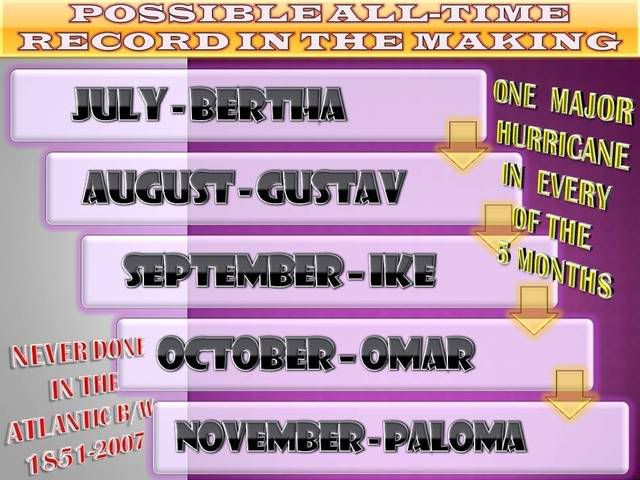
This year and 2005 are the only seasons that we've had major hurricanes in the Atlantic in four separate months--July, August, September, and October. If Paloma becomes a major hurricane, it will make 2008 the first year since record keeping began in 1851 to feature major hurricanes in five separate months.
Historical note
This year and 2005 are the only seasons that we've had major hurricanes in the Atlantic in four separate months--July, August, September, and October. If Paloma becomes a major hurricane, it will make 2008 the first year since record keeping began in 1851 to feature major hurricanes in five separate months.
0 likes
Re: ATL: PALOMA - Hurricane - Discussion
GFS ensemble members..heck Paloma might not make it out of the caribbean.
http://www.wunderground.com/tropical/tracking/at200817_ensmodel.html#a_topad
http://www.wunderground.com/tropical/tracking/at200817_ensmodel.html#a_topad
0 likes
-
HURAKAN

- Professional-Met

- Posts: 46084
- Age: 39
- Joined: Thu May 20, 2004 4:34 pm
- Location: Key West, FL
- Contact:
Re: ATL: PALOMA - Hurricane - Discussion
ronjon wrote:Interesting fact from Jeff Masters:
Historical note
This year and 2005 are the only seasons that we've had major hurricanes in the Atlantic in four separate months--July, August, September, and October. If Paloma becomes a major hurricane, it will make 2008 the first year since record keeping began in 1851 to feature major hurricanes in five separate months.
It was in the previous page.
0 likes

-
gatorcane
- S2K Supporter
- Posts: 23708
- Age: 48
- Joined: Sun Mar 13, 2005 3:54 pm
- Location: Boca Raton, FL
Re: ATL: PALOMA - Hurricane - Discussion
About to make a turn to the right, note large trough heading east in the GOM:

0 likes
Who is online
Users browsing this forum: No registered users and 78 guests