

tropical Storm Francine will bring heavy rainfall across portions of Lousiana. Four to eight inches of rain can be expected, with isolated amounts of up to 12 inches possible. - http://www.weather.gov/safety/flood
This is for my area's Flood Watch that is on from now to Thursday.
ATL: FRANCINE - Remnants - Discussion
Moderator: S2k Moderators
Re: ATL: FRANCINE - Tropical Storm - Discussion
0 likes
Personal Forecast Disclaimer:
The posts in this forum are NOT official forecast and should not be used as such. They are just the opinion of the poster and may or may not be backed by sound meteorological data. They are NOT endorsed by any professional institution or storm2k.org. For official information, please refer to the NHC and NWS products.
The posts in this forum are NOT official forecast and should not be used as such. They are just the opinion of the poster and may or may not be backed by sound meteorological data. They are NOT endorsed by any professional institution or storm2k.org. For official information, please refer to the NHC and NWS products.

Re: ATL: FRANCINE - Tropical Storm - Discussion
WPAC and SPAC called, they want their formative typhoon with huge, ultra-cold CDO back.
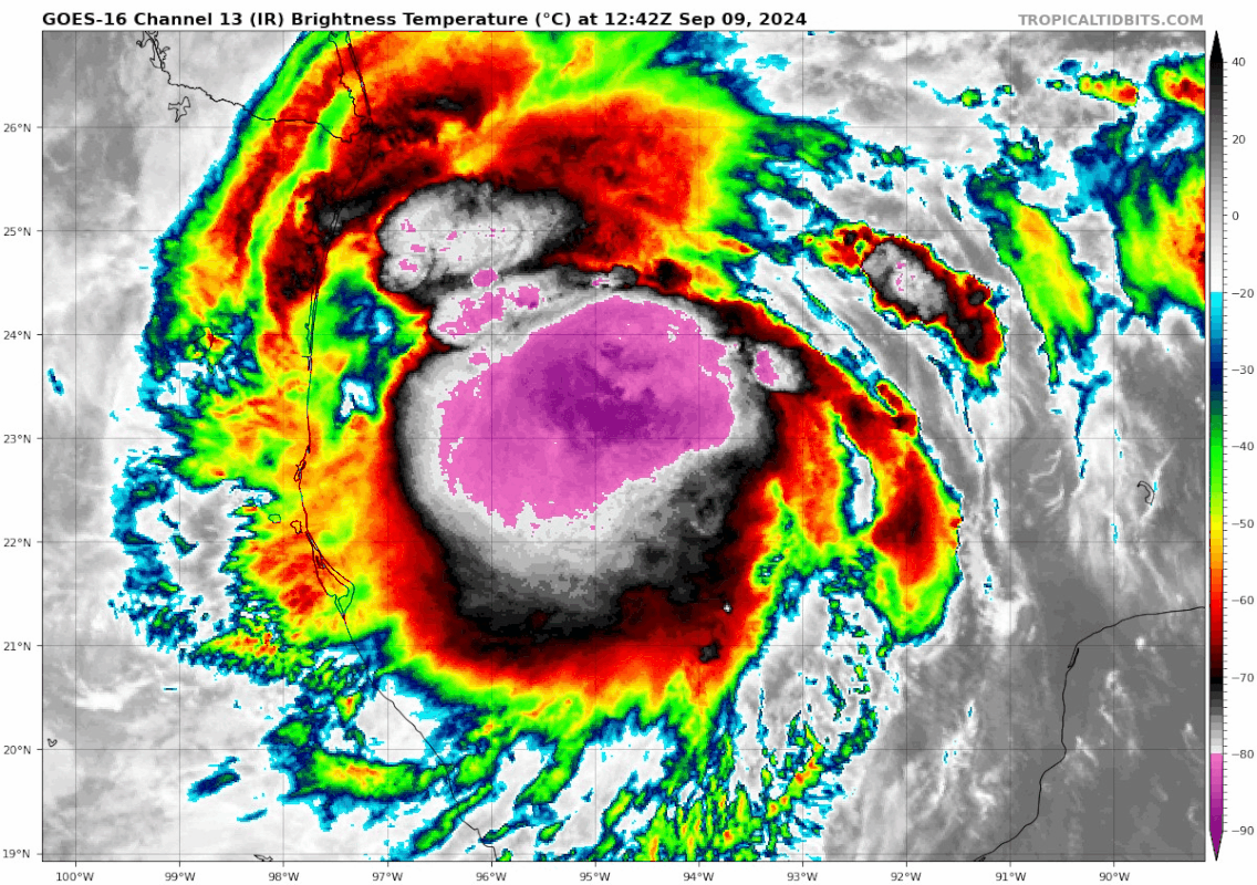
Francine almost fills up the entire western Gulf:
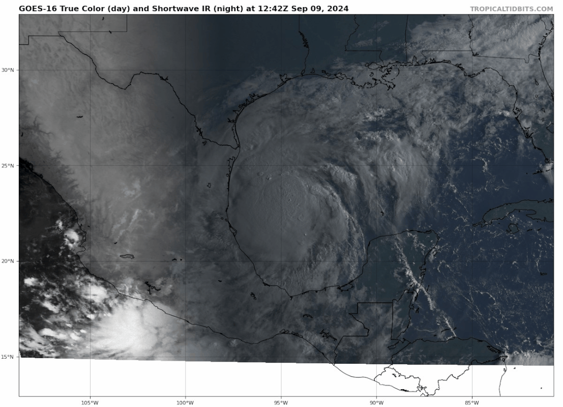
Francine almost fills up the entire western Gulf:
9 likes
TC naming lists: retirements and intensity
Most aggressive Advisory #1's in North Atlantic (cr. kevin for starting the list)
Most aggressive Advisory #1's in North Atlantic (cr. kevin for starting the list)
-
MississippiWx

- S2K Supporter

- Posts: 1720
- Joined: Sat Aug 14, 2010 1:44 pm
- Location: Hattiesburg, Mississippi
Re: ATL: FRANCINE - Tropical Storm - Discussion
Center relocation found around 23.5N 95.6W...dead center of the convective mass. Appears to finally be consolidating a core too.
1 likes
This post is not an official forecast and should not be used as such. It is just the opinion of MississippiWx and may or may not be backed by sound meteorological data. It is not endorsed by any professional institution including storm2k.org. For Official Information please refer to the NHC and NWS products.
Re: ATL: SIX - Potential Tropical Cyclone - Discussion
tolakram wrote:Hypercane_Kyle wrote:I guess the Atlantic is capable of producing Tropical Storms this month after all.
https://i.imgur.com/tlcMMlJ.jpeg
Record gulf heat, peak of hurricane season, one hurricane on the menu. Fingers crossed that whatever has been limiting development also limits intensity.
Ditto that....
1 likes
Re: ATL: FRANCINE - Tropical Storm - Discussion
MississippiWx wrote:Center relocation found around 23.5N 95.6W...dead center of the convective mass. Appears to finally be consolidating a core too.
I have to think this may accelerate intensification ahead of schedule, even beyond the hurricane models (whose 6z runs range between Cat 1 and borderline MH).
The posts in this forum are NOT official forecasts and should not be used as such. They are just the opinion of the poster and may or may not be backed by sound meteorological data. They are NOT endorsed by any professional institution or STORM2K. For official information, please refer to products from the NHC and NWS.
1 likes
TC naming lists: retirements and intensity
Most aggressive Advisory #1's in North Atlantic (cr. kevin for starting the list)
Most aggressive Advisory #1's in North Atlantic (cr. kevin for starting the list)
-
Pipelines182
- Tropical Storm

- Posts: 159
- Joined: Tue Jul 02, 2024 8:46 am
Re: ATL: FRANCINE - Tropical Storm - Discussion
GCANE wrote:This may rapidly increase in intensity starting in a couple hours.
Could last thru the afternoon.
Note the large hot tower firing off south of the CoC.
I think it's going to need more than a couple hours. The circulation is still very broad, keeps moving around, and there's smaller satellite circulations rotating around the main CoC. It needs to really consolidate before any serious deepening can occur. It could honestly stay like this for the entire day, it's hard to predict when it will consolidate.
0 likes
Re: ATL: FRANCINE - Tropical Storm - Discussion
Saw this on Facebook: New data from Tropical Storm Francine shows the storm surge threat is increasing dramatically for the Louisiana coast. Inundations of 5-10 feet are possible from Cameron to Port Fourchon and 4-7 feet to the mouth of the Mississippi River. Storm surge up to 5 feet is possible across other parts of the TX, LA, and MS coastlines.
0 likes
Personal Forecast Disclaimer:
The posts in this forum are NOT official forecast and should not be used as such. They are just the opinion of the poster and may or may not be backed by sound meteorological data. They are NOT endorsed by any professional institution or storm2k.org. For official information, please refer to the NHC and NWS products.
The posts in this forum are NOT official forecast and should not be used as such. They are just the opinion of the poster and may or may not be backed by sound meteorological data. They are NOT endorsed by any professional institution or storm2k.org. For official information, please refer to the NHC and NWS products.

Re: ATL: FRANCINE - Tropical Storm - Discussion
Increasing rain rate. Last measurement from recon = 40 mm/hr
0 likes
Re: ATL: FRANCINE - Tropical Storm - Discussion
0 likes
Personal Forecast Disclaimer:
The posts in this forum are NOT official forecast and should not be used as such. They are just the opinion of the poster and may or may not be backed by sound meteorological data. They are NOT endorsed by any professional institution or storm2k.org. For official information, please refer to the NHC and NWS products.
The posts in this forum are NOT official forecast and should not be used as such. They are just the opinion of the poster and may or may not be backed by sound meteorological data. They are NOT endorsed by any professional institution or storm2k.org. For official information, please refer to the NHC and NWS products.
-
MississippiWx
- S2K Supporter
- Posts: 1720
- Joined: Sat Aug 14, 2010 1:44 pm
- Location: Hattiesburg, Mississippi
Re: ATL: FRANCINE - Tropical Storm - Discussion
Teban54 wrote:MississippiWx wrote:Center relocation found around 23.5N 95.6W...dead center of the convective mass. Appears to finally be consolidating a core too.
I have to think this may accelerate intensification ahead of schedule, even beyond the hurricane models (whose 6z runs range between Cat 1 and borderline MH).The posts in this forum are NOT official forecasts and should not be used as such. They are just the opinion of the poster and may or may not be backed by sound meteorological data. They are NOT endorsed by any professional institution or STORM2K. For official information, please refer to products from the NHC and NWS.
Yeah, remains to be seen. More times than not, these huge convective blobs in the early stages of tropical development fade away and start over. None of the models I've seen really take off with intensification today.
0 likes
This post is not an official forecast and should not be used as such. It is just the opinion of MississippiWx and may or may not be backed by sound meteorological data. It is not endorsed by any professional institution including storm2k.org. For Official Information please refer to the NHC and NWS products.
-
Pipelines182
- Tropical Storm
- Posts: 159
- Joined: Tue Jul 02, 2024 8:46 am
Re: ATL: FRANCINE - Tropical Storm - Discussion
MississippiWx wrote:Teban54 wrote:MississippiWx wrote:Center relocation found around 23.5N 95.6W...dead center of the convective mass. Appears to finally be consolidating a core too.
I have to think this may accelerate intensification ahead of schedule, even beyond the hurricane models (whose 6z runs range between Cat 1 and borderline MH).The posts in this forum are NOT official forecasts and should not be used as such. They are just the opinion of the poster and may or may not be backed by sound meteorological data. They are NOT endorsed by any professional institution or STORM2K. For official information, please refer to products from the NHC and NWS.
Yeah, remains to be seen. More times than not, these huge convective blobs in the early stages of tropical development fade away and start over. None of the models I've seen really take off with intensification today.
This, I would bet money we'll see significant warming of the CDO today at some point.
0 likes

Re: ATL: FRANCINE - Tropical Storm - Discussion
I'm sure this has been already addressed but I am unaware. What is going on with the GOES sat.??
0 likes
Andy D
(For official information, please refer to the NHC and NWS products.)
(For official information, please refer to the NHC and NWS products.)
-
MississippiWx
- S2K Supporter
- Posts: 1720
- Joined: Sat Aug 14, 2010 1:44 pm
- Location: Hattiesburg, Mississippi
Re: ATL: FRANCINE - Tropical Storm - Discussion
Pipelines182 wrote:MississippiWx wrote:Teban54 wrote:I have to think this may accelerate intensification ahead of schedule, even beyond the hurricane models (whose 6z runs range between Cat 1 and borderline MH).The posts in this forum are NOT official forecasts and should not be used as such. They are just the opinion of the poster and may or may not be backed by sound meteorological data. They are NOT endorsed by any professional institution or STORM2K. For official information, please refer to products from the NHC and NWS.
Yeah, remains to be seen. More times than not, these huge convective blobs in the early stages of tropical development fade away and start over. None of the models I've seen really take off with intensification today.
This, I would bet money we'll see significant warming of the CDO today at some point.
If it doesn't and the center is truly tightening like last pass, we may have something more interesting on our hands. The environment is currently very favorable.
0 likes
This post is not an official forecast and should not be used as such. It is just the opinion of MississippiWx and may or may not be backed by sound meteorological data. It is not endorsed by any professional institution including storm2k.org. For Official Information please refer to the NHC and NWS products.
-
ColdFusion

- S2K Supporter
- Posts: 452
- Joined: Wed Feb 13, 2008 3:46 pm
- Location: Addison, TX
Re: ATL: FRANCINE - Tropical Storm - Discussion
Like Ortt pointed out, weakening is the trend right now, but doesnt mean it wont ramp back up later.
https://www.star.nesdis.noaa.gov/GOES/sector_band.php?sat=G16§or=gm&band=13&length=24
https://www.star.nesdis.noaa.gov/GOES/sector_band.php?sat=G16§or=gm&band=13&length=24
0 likes
Re: ATL: FRANCINE - Tropical Storm - Discussion
MississippiWx wrote:Center relocation found around 23.5N 95.6W...dead center of the convective mass. Appears to finally be consolidating a core too.
I hate going by the over enhanced Color IR but on appearance (prior to missing sat frames), I was surmising the same. I'm wondering if we'll continue to see an even further north relocation than that. That would be my quick-take impression. If so, then I think we'd be looking at an accelerated process of inner core alignment and faster intensification than expected. The flip side of course might have Francine with its MLC further north suggesting still a significant North-South tilt. Glad that recon is there, given the difficulty of viewing vis sat. through that CDO.
0 likes
Andy D
(For official information, please refer to the NHC and NWS products.)
(For official information, please refer to the NHC and NWS products.)
-
Pipelines182
- Tropical Storm
- Posts: 159
- Joined: Tue Jul 02, 2024 8:46 am
Re: ATL: FRANCINE - Tropical Storm - Discussion
ColdFusion wrote:Like Ortt pointed out, weakening is the trend right now, but doesnt mean it wont ramp back up later.
https://www.star.nesdis.noaa.gov/GOES/sector_band.php?sat=G16§or=gm&band=13&length=24
ha and there it is, warming of the CDO right on schedule. This happens virtually every time when a wave turns into a TC. I believe it's due to the way a wave/low builds convection vs the way a TC does, the processes are different, maybe someone with more technical knowledge can chime in.
If we start seeing hot towers around the core firing up, we're going to be in the RI danger zone, let's wait and see what happens.
0 likes
Re: ATL: FRANCINE - Tropical Storm - Discussion
chaser1 wrote:I'm sure this has been already addressed but I am unaware. What is going on with the GOES sat.??
Appears to be some geomagnetic activity.
https://solarham.com/globald.htm
Could be due to that.
1 likes

Re: ATL: FRANCINE - Tropical Storm - Discussion
ColdFusion wrote:Like Ortt pointed out, weakening is the trend right now, but doesnt mean it wont ramp back up later.
https://www.star.nesdis.noaa.gov/GOES/sector_band.php?sat=G16§or=gm&band=13&length=24
Typically these large CDOs (CCC if you will) are unsustainable, research has shown they can indicate halted intensification but may mask structural changes. In this case Francine’s intensity is roughly the same but the storm now has a tight LLC roughly stacked with the MLC. I expected structured convection to replace the burst as it fades.
1 likes
Kendall -> SLO -> PBC
Memorable Storms: Katrina (for its Florida landfall...) Wilma Matthew Irma
Memorable Storms: Katrina (for its Florida landfall...) Wilma Matthew Irma


-
MississippiWx
- S2K Supporter
- Posts: 1720
- Joined: Sat Aug 14, 2010 1:44 pm
- Location: Hattiesburg, Mississippi
Re: ATL: FRANCINE - Tropical Storm - Discussion
ColdFusion wrote:Like Ortt pointed out, weakening is the trend right now, but doesnt mean it wont ramp back up later.
https://www.star.nesdis.noaa.gov/GOES/sector_band.php?sat=G16§or=gm&band=13&length=24
Some of the warming that is occurring is due to the sun warming the cloud tops, not necessarily weakening convection.
0 likes
This post is not an official forecast and should not be used as such. It is just the opinion of MississippiWx and may or may not be backed by sound meteorological data. It is not endorsed by any professional institution including storm2k.org. For Official Information please refer to the NHC and NWS products.
Who is online
Users browsing this forum: No registered users and 35 guests