Texas Winter 2010-2011

Winter Weather Discussion

Moderator: S2k Moderators

Forum rules

The posts in this forum are NOT official forecast and should not be used as such. They are just the opinion of the poster and may or may not be backed by sound meteorological data. They are NOT endorsed by any professional institution or STORM2K.

Help Support Storm2K
Message
Author
User avatar
Rgv20
S2K Supporter
S2K Supporter
Posts: 2466
Age: 39
Joined: Wed Jan 05, 2011 5:42 pm
Location: Edinburg/McAllen Tx

#3001 Postby Rgv20 » Mon Jan 24, 2011 9:02 am

Edited by wxman57:

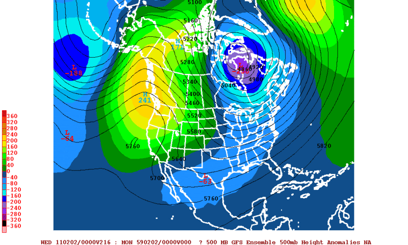
The first image below is the GFS ensemble forecast of 500mb (mid level) height anomalies valid Tuesday evening, February 1st. The map shows building high pressure over the Gulf of Alaska and Pacific Northwest and a deepening low over the eastern Hudson Bay region extending all the way southwest to west of Texas.

The suggestion here is that the building ridge will drive very cold air southward out of Canada but that the trof axis will remain west of the cold air next Tue-Wed. This is a setup for snow across the Deep South.

Image

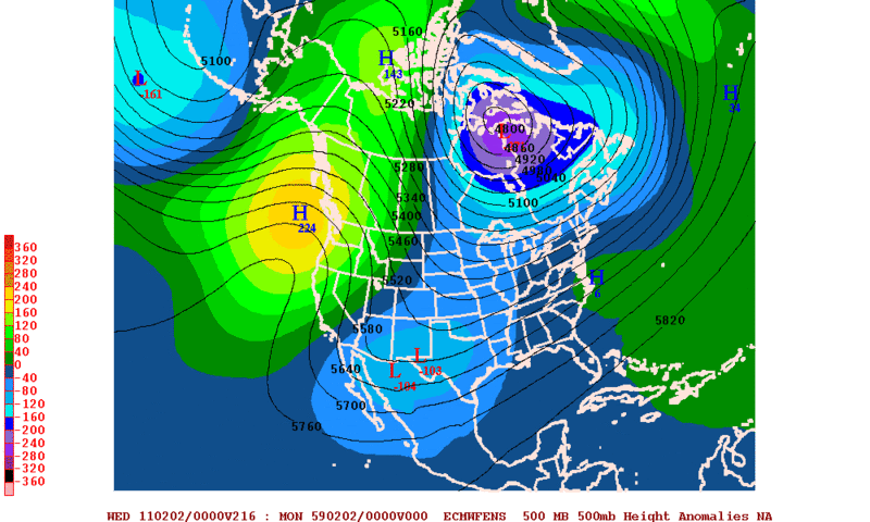
The European version of the same map has an even deeper area of low pressure west of the cold air across the southwestern U.S. next Tuesday evening. The European model is more bullish on southern stream energy with the cold air in place, meaning a greater chance for Deep South snow next week.
Image
0 likes   
The following post is NOT an official forecast and should not be used as such. It is just the opinion of the poster and may or may not be backed by sound meteorological data. It is NOT endorsed by any professional institution including storm2k.org For Official Information please refer to the NHC and NWS products.

User avatar
Portastorm
Storm2k Moderator
Storm2k Moderator
Posts: 9914
Age: 63
Joined: Fri Jul 11, 2003 9:16 am
Location: Round Rock, TX
Contact:

Re: Texas Winter 2010-2011

#3002 Postby Portastorm » Mon Jan 24, 2011 9:37 am

:uarrow:

Hey gang ... when you post model maps, how about a little clarification or description. Put it in context otherwise it is not much help to those here who don't understand. We have a wide variety of weather knowledge here and we should be mindful of all of our members.

Thanks!
0 likes   

natlib
Tropical Storm
Tropical Storm
Posts: 159
Joined: Tue Dec 01, 2009 10:09 am
Location: San Angelo, TX

Re: Texas Winter 2010-2011

#3003 Postby natlib » Mon Jan 24, 2011 9:39 am

30% chance of snow for San Angelo after midnight tonight. Where did this come from? This just goes to show how hard winter weather is to forecast.
0 likes   

benrayrog
Tropical Depression
Tropical Depression
Posts: 53
Age: 66
Joined: Mon Feb 22, 2010 4:35 pm
Location: Malakoff

Re: Texas Winter 2010-2011

#3004 Postby benrayrog » Mon Jan 24, 2011 9:40 am

Portastorm wrote::uarrow:

Hey gang ... when you post model maps, how about a little clarification or description. Put it in context otherwise it is not much help to those here who don't understand. We have a wide variety of weather knowledge here and we should be mindful of all of our members.

Thanks!


Thanks, Portastorm. That is a great suggestion and would be a great help to some of us.!
0 likes   

User avatar
southerngale
Retired Staff
Retired Staff
Posts: 27418
Joined: Thu Oct 10, 2002 1:27 am
Location: Southeast Texas (Beaumont area)

#3005 Postby southerngale » Mon Jan 24, 2011 9:48 am

Yeah. Most people are just reading these threads and not commenting. To the majority of people, the model maps mean nothing without an explanation. We were all at that level at one point. A brief (or long) explanation can really help others learn.

As for that 30% chance of snow for San Angelo, I saw the NWS forecaster for that area mention yesterday that the forecast could change and snow was possible, or something to that effect. Hope you get some!!
0 likes   
Please support Storm2k by making a donation today. It is greatly appreciated! Click here: Image

Image my Cowboys Image my RocketsImage my Astros

Mr. Weather
Tropical Low
Tropical Low
Posts: 41
Joined: Thu Jan 06, 2011 9:27 am
Location: Houston Area

Re: Texas Winter 2010-2011

#3006 Postby Mr. Weather » Mon Jan 24, 2011 9:49 am

is SE Texas chances for getting some wintry weather around the 1st of February getting better or worse j/w thanks
0 likes   

MSUDawg
Tropical Storm
Tropical Storm
Posts: 103
Joined: Fri Jan 07, 2011 11:07 pm
Location: Carrollton

#3007 Postby MSUDawg » Mon Jan 24, 2011 10:13 am

Thanks Porta, the graphics sure are purty but I don't have a clue what 5% of it means as of now.
Like the model rgv just posted, I know from the labeling it is 500mb "anamolies" but I have no idea on when
or what exactly it is showing besides the "high" pressure over the western coast and "low" pressure over the heartland in the shape of a musical 16th note.

It just confuses me that shows a low pressure when everything else talks about high pressure with all this cold.

someone hand the "weather for idiots" book please.
0 likes   

User avatar
wxman57
Moderator-Pro Met
Moderator-Pro Met
Posts: 23004
Age: 67
Joined: Sat Jun 21, 2003 8:06 pm
Location: Houston, TX (southwest)

Re: Texas Winter 2010-2011

#3008 Postby wxman57 » Mon Jan 24, 2011 10:49 am

Portastorm wrote::uarrow:

Hey gang ... when you post model maps, how about a little clarification or description. Put it in context otherwise it is not much help to those here who don't understand. We have a wide variety of weather knowledge here and we should be mindful of all of our members.

Thanks!


I edited the post above to add a discussion of what I see there.
0 likes   

utweather
Category 1
Category 1
Posts: 252
Joined: Tue Jan 26, 2010 10:51 pm
Location: SE Austin, TX

Re: Re:

#3009 Postby utweather » Mon Jan 24, 2011 10:52 am

Ntxw wrote:
Brandon8181 wrote:
Kansas City
OF GRAVER CONCERN HOWEVER IS THE LOOMING PROSPECT OF THE COLDEST AIR
OF THE WINTER SEASON SLATED TO ARRIVE FOR THE END OF THE MONTH.
THERE IS INCREASING CONSENSUS AMONG THE MEDIUM RANGE MODEL SUITE
THAT THE DUAL CORED ALEUTIAN VORTEX WILL UNDERGO ADDITIONAL
INTENSIFICATION OVER THE NEXT SEVERAL DAYS AS AMPLE UPSTREAM
ENERGY ARRIVES ACROSS THE NORTHERN PACIFIC. A FORCED DOWNSTREAM
SHORTWAVE RIDGE WILL ALIGN ITSELF ALONG THE PACIFIC COASTLINE AND
THROUGH THE STATE OF ALASKA...PHASING WITH THE PRE-EXISTING RIDGING
ALONG THE US PACIFIC COASTLINE. THE PROSPECTS OF A SINGLE RIDGE AXIS
EXTENDING FROM CALIFORNIA INTO THE ARCTIC CIRCLE DOES NOT BODE WELL
FOR US...ESPECIALLY AS THE POLAR VORTEX SLOWLY MIGRATES BACK
SOUTHWARD TOWARD HUDSON BAY. THIS TELECONNECTION WOULD SPELL A
DIRECT CROSS-POLAR FLOW FROM THE HEART OF EASTERN ALASKA/WESTERN
CANADA...DISLODGING THE FRIGID AIRMASS ALONG THE FRONT RANGE AND
INTO THE CENTRAL US BY THE WEEKEND WHICH MODELS REALIZE AS A
SPRAWLING SURFACE RIDGE OF 1045 TO 1050+ MB.


Music to my ears:-)
0 likes   

User avatar
Tireman4
S2K Supporter
S2K Supporter
Posts: 5853
Age: 59
Joined: Fri Jun 30, 2006 1:08 pm
Location: Humble, Texas
Contact:

Re: Texas Winter 2010-2011

#3010 Postby Tireman4 » Mon Jan 24, 2011 10:52 am

wxman57 wrote:
Portastorm wrote::uarrow:

Hey gang ... when you post model maps, how about a little clarification or description. Put it in context otherwise it is not much help to those here who don't understand. We have a wide variety of weather knowledge here and we should be mindful of all of our members.

Thanks!


I edited the post above to add a discussion of what I see there.


Thank you Wxman57. We appreciate it.
0 likes   

User avatar
srainhoutx
S2K Supporter
S2K Supporter
Posts: 6919
Age: 67
Joined: Sun Jan 14, 2007 11:34 am
Location: Haywood County, NC
Contact:

Re: Texas Winter 2010-2011

#3011 Postby srainhoutx » Mon Jan 24, 2011 11:17 am

Impact Weather has an update for those that are interested...

http://www.youtube.com/impactweather
0 likes   
Carla/Alicia/Jerry(In The Eye)/Michelle/Charley/Ivan/Dennis/Katrina/Rita/Wilma/Ike/Harvey

Member: National Weather Association
Wx Infinity Forums
http://wxinfinity.com/index.php

Facebook.com/WeatherInfinity
Twitter @WeatherInfinity

User avatar
Ivanhater
Storm2k Moderator
Storm2k Moderator
Posts: 11162
Age: 38
Joined: Fri Jul 01, 2005 8:25 am
Location: Pensacola

Re: Texas Winter 2010-2011

#3012 Postby Ivanhater » Mon Jan 24, 2011 11:20 am

Thanks for the video link, srain.

Wxman57: If you don't mind, could you head over to the deep south thread and give us an update or 2 when warranted?
0 likes   
Michael

User avatar
txagwxman
Professional-Met
Professional-Met
Posts: 960
Joined: Thu Dec 24, 2009 3:26 pm
Location: Tomball, TX

#3013 Postby txagwxman » Mon Jan 24, 2011 11:39 am

And all those cold GFS fans for the last few days can say goodbye to the ice storm.

GFS totally backs off.

How is that for nutz?
0 likes   
“If you thought that science was certain - well, that is just an error on your part.”

User avatar
wxman22
Category 5
Category 5
Posts: 1503
Joined: Mon Jan 30, 2006 12:39 am
Location: Wichita Falls, TX
Contact:

Re: Texas Winter 2010-2011

#3014 Postby wxman22 » Mon Jan 24, 2011 11:44 am

Seems the GFS is struggling with what it wants to do with the cold air, while it still shows the storm system the cold air never really penetrates into the state. Im not really buying that right now.
0 likes   

User avatar
PTrackerLA
Category 5
Category 5
Posts: 5277
Age: 41
Joined: Thu Oct 10, 2002 8:40 pm
Location: Lafayette, LA

Re: Texas Winter 2010-2011

#3015 Postby PTrackerLA » Mon Jan 24, 2011 11:46 am

Yep GFS has backed way off, shows at best a chilly rain early next week now for the deep south.
0 likes   

User avatar
perk
Category 3
Category 3
Posts: 825
Joined: Mon Aug 09, 2004 9:35 am
Location: Richmond Texas

Re:

#3016 Postby perk » Mon Jan 24, 2011 11:50 am

txagwxman wrote:And all those cold GFS fans for the last few days can say goodbye to the ice storm.

GFS totally backs off.

How is that for nutz?

So what should we take from the GFS knowing that the Euro and the Canadian has a totally different scenario.
0 likes   

User avatar
Rgv20
S2K Supporter
S2K Supporter
Posts: 2466
Age: 39
Joined: Wed Jan 05, 2011 5:42 pm
Location: Edinburg/McAllen Tx

#3017 Postby Rgv20 » Mon Jan 24, 2011 11:51 am

GFS has practically the same set up at the 500mb level as past runs but as stated above it cant decide what to do with the cold air. Understandable because its 7 to 10 days away.
0 likes   
The following post is NOT an official forecast and should not be used as such. It is just the opinion of the poster and may or may not be backed by sound meteorological data. It is NOT endorsed by any professional institution including storm2k.org For Official Information please refer to the NHC and NWS products.

User avatar
somethingfunny
ChatStaff
ChatStaff
Posts: 3926
Age: 37
Joined: Thu May 31, 2007 10:30 pm
Location: McKinney, Texas

Re: Texas Winter 2010-2011

#3018 Postby somethingfunny » Mon Jan 24, 2011 11:52 am

PTrackerLA wrote:Yep GFS has backed way off, shows at best a chilly rain early next week now for the deep south.


It always seems to do that around this time frame, only to begin trending back around 72 hours and then show a full fledged storm again by 24 hours. As some others have said, the really memorable storms tend to be depicted with a relatively high amount of consistency and agreement by the long range models, only to disappear at mid-range and then reappear at the short range.

Or it could just be cold rain or dry face slicing windchills. Patience, grasshopper. :lol:
0 likes   
I am not a meteorologist, and any posts made by me are not official forecasts or to be interpreted as being intelligent. These posts are just my opinions and are probably silly opinions.

User avatar
somethingfunny
ChatStaff
ChatStaff
Posts: 3926
Age: 37
Joined: Thu May 31, 2007 10:30 pm
Location: McKinney, Texas

Re: Texas Winter 2010-2011

#3019 Postby somethingfunny » Mon Jan 24, 2011 11:55 am

natlib wrote:30% chance of snow for San Angelo after midnight tonight. Where did this come from? This just goes to show how hard winter weather is to forecast.


Hehe....I wonder if a certain member of this board who works the overnight shift at the San Angelo NWS office had anything to do with making that decision. I would love to hear his reasoning, and his thoughts on DFW's chances over the next 24 hour period. ;)
Last edited by somethingfunny on Mon Jan 24, 2011 11:58 am, edited 1 time in total.
0 likes   
I am not a meteorologist, and any posts made by me are not official forecasts or to be interpreted as being intelligent. These posts are just my opinions and are probably silly opinions.

User avatar
Ivanhater
Storm2k Moderator
Storm2k Moderator
Posts: 11162
Age: 38
Joined: Fri Jul 01, 2005 8:25 am
Location: Pensacola

Re: Texas Winter 2010-2011

#3020 Postby Ivanhater » Mon Jan 24, 2011 11:56 am

Could we really expect the GFS to show a snow storm for the Deep south every run, every day, for 2 weeks straight? It just is not going to happen. As others have said, look at the 500 mb setup and it still looks on track. Also the ensemble mean is still showing a great set-up.
0 likes   
Michael


Return to “Winter Weather”

Who is online

Users browsing this forum: No registered users and 41 guests