ATL: IAN - Models
Moderator: S2k Moderators
Re: ATL: IAN - Models
GFS looks a little further east for sure but is a bit weaker. I wouldn't take the intensity seriously as it initialized too weak.
4 likes
-
eastcoastFL

- Category 5

- Posts: 3996
- Age: 44
- Joined: Thu Apr 12, 2007 12:29 pm
- Location: Palm City, FL
Re: ATL: IAN - Models
Sanibel wrote:Just spent the last few hours pulling save-ables up into the house from the ground-level garage that is tucked under it...We are on 13 foot pilings by code at the ground level...
That leaves just tomorrow to do a triage for things that will leave with me in the cars...
This might be the big one for Sanibel...We might finally get the bad surge-er we've been spared up to now...
The posts in this forum are NOT official forecasts and should not be used as such. They are just the opinion of the poster and may or may not be backed by sound meteorological data. They are NOT endorsed by any professional institution or STORM2K. For official information, please refer to products from the National Hurricane Center and National Weather Service.
Sorry to hear this is effecting you but also glad to hear you’re heading for safety. Hopefully you’ll be spared again and be back in your home soon enough.
4 likes
Personal Forecast Disclaimer:
The posts in this forum are NOT official forecast and should not be used as such. They are just the opinion of the poster and may or may not be backed by sound meteorological data. They are NOT endorsed by any professional institution or storm2k.org. For official information, please refer to the NHC and NWS products.
The posts in this forum are NOT official forecast and should not be used as such. They are just the opinion of the poster and may or may not be backed by sound meteorological data. They are NOT endorsed by any professional institution or storm2k.org. For official information, please refer to the NHC and NWS products.

Re: ATL: IAN - Models
0z Euro heading for Sarasota County on this run.
Edit: Meant to type the GFS, long day today.
Edit: Meant to type the GFS, long day today.
Last edited by NDG on Mon Sep 26, 2022 10:53 pm, edited 1 time in total.
1 likes
Re: ATL: IAN - Models
NDG wrote:caneman wrote:NDG wrote:0z ICON is very similar to the 18z Euro.
The Euro run already looks incorrect and too far East. The Map you posted earlier shows it at 83 after crossing Cuba and its already 83.4.
That is incorrect, the 18z Euro shows it leaving Cuba 83.6 W.
Due north of where it is right now, according to that run it should begin the true due north track soon.
https://i.imgur.com/3PIEDpd.gif
Can you post that image? The image I saw was 83.
1 likes
-
eastcoastFL
- Category 5
- Posts: 3996
- Age: 44
- Joined: Thu Apr 12, 2007 12:29 pm
- Location: Palm City, FL
Re: ATL: IAN - Models
NDG wrote:0z Euro heading for Sarasota County on this run.
I’m not seeing it on TT yet
1 likes
Personal Forecast Disclaimer:
The posts in this forum are NOT official forecast and should not be used as such. They are just the opinion of the poster and may or may not be backed by sound meteorological data. They are NOT endorsed by any professional institution or storm2k.org. For official information, please refer to the NHC and NWS products.
The posts in this forum are NOT official forecast and should not be used as such. They are just the opinion of the poster and may or may not be backed by sound meteorological data. They are NOT endorsed by any professional institution or storm2k.org. For official information, please refer to the NHC and NWS products.
Re: ATL: IAN - Models
eastcoastFL wrote:NDG wrote:0z Euro heading for Sarasota County on this run.
I’m not seeing it on TT yet
I think he means the GFS.
1 likes

Re: ATL: IAN - Models
Sarasota/Venice then looks to stall.

Last edited by BobHarlem on Mon Sep 26, 2022 10:56 pm, edited 1 time in total.
2 likes
-
eastcoastFL
- Category 5
- Posts: 3996
- Age: 44
- Joined: Thu Apr 12, 2007 12:29 pm
- Location: Palm City, FL
Re: ATL: IAN - Models
BobHarlem wrote:Venice
https://i.imgur.com/1R4FcOs.png
Please tell me it doesn’t make the trek cross state like the last two models…
2 likes
Personal Forecast Disclaimer:
The posts in this forum are NOT official forecast and should not be used as such. They are just the opinion of the poster and may or may not be backed by sound meteorological data. They are NOT endorsed by any professional institution or storm2k.org. For official information, please refer to the NHC and NWS products.
The posts in this forum are NOT official forecast and should not be used as such. They are just the opinion of the poster and may or may not be backed by sound meteorological data. They are NOT endorsed by any professional institution or storm2k.org. For official information, please refer to the NHC and NWS products.
-
Meteorcane

- Category 2

- Posts: 559
- Joined: Thu Jul 21, 2011 6:49 am
- Location: North Platte Nebraska
Re: ATL: IAN - Models
GFS largely stalls south of Tampa (between Venice and Sarasota), would spare Tampa the surge with that track, but would drop tons of rain on its northern side (and still bring strong winds to the Tampa metro)... would be a bad surge situation for the Fort Myers area.
2 likes
Re: ATL: IAN - Models
1 likes

Re: ATL: IAN - Models
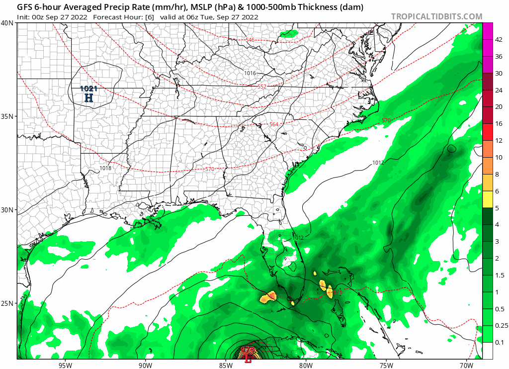
0z GFS up to 72 hrs
1 likes
TC naming lists: retirements and intensity
Most aggressive Advisory #1's in North Atlantic (cr. kevin for starting the list)
Most aggressive Advisory #1's in North Atlantic (cr. kevin for starting the list)
-
AxaltaRacing24
- Category 5
- Posts: 1774
- Age: 25
- Joined: Wed Jul 27, 2016 11:14 am
- Location: Jupiter, FL
Re: ATL: IAN - Models
eastcoastFL wrote:BobHarlem wrote:Venice
https://i.imgur.com/1R4FcOs.png
Please tell me it doesn’t make the trek cross state like the last two models…
Not on this run, but the synoptics are hinting at it if there is one more east shift.
2 likes
Re: ATL: IAN - Models
NDG wrote:Wow, GFS stalls it right over Sarasota/Bradenton area.
And St. PETE - Tampa
1 likes
-
Meteorcane
- Category 2
- Posts: 559
- Joined: Thu Jul 21, 2011 6:49 am
- Location: North Platte Nebraska
Re: ATL: IAN - Models
With this GFS solution the Tampa area would trade the surge for prodigious rainfall (as precipitation becomes displaced to the north as the system is sheared), swath of 30-45 inch totals.

5 likes
Re: ATL: IAN - Models
Meteorcane wrote:With this GFS solution the Tampa area would trade the surge for prodigious rainfall (as precipitation becomes displaced to the north as the system is sheared), swath of 30-45 inch totals.
https://m1o.pivotalweather.com/maps/models/gfs/2022092700/081/qpf_acc.us_se.png
Holy Cow! Biblical proportions.
Last edited by caneman on Mon Sep 26, 2022 11:01 pm, edited 1 time in total.
1 likes

-
Blown Away

- S2K Supporter

- Posts: 10253
- Joined: Wed May 26, 2004 6:17 am
Re: ATL: IAN - Models
AxaltaRacing24 wrote:eastcoastFL wrote:BobHarlem wrote:Venice
https://i.imgur.com/1R4FcOs.png
Please tell me it doesn’t make the trek cross state like the last two models…
Not on this run, but the synoptics are hinting at it if there is one more east shift.
I think next GFS run it’s more progressive to the NE, Ian is not hanging around Bradenton in 4 days. JMHO
3 likes
Hurricane Eye Experience: David 79, Irene 99, Frances 04, Jeanne 04, Wilma 05… Hurricane Brush Experience: Andrew 92, Erin 95, Floyd 99, Matthew 16, Irma 17, Ian 22, Nicole 22…
Who is online
Users browsing this forum: No registered users and 25 guests