ravyrn wrote:Why didn't DFW issue a hard freeze warning for tonight?
Call them and ask. They usually pick up the phone. I'm being serious.
Moderator: S2k Moderators
 The posts in this forum are NOT official forecast and should not be used as such. They are just the opinion of the poster and may or may not be backed by sound meteorological data. They are NOT endorsed by any professional institution or STORM2K.

ravyrn wrote:Why didn't DFW issue a hard freeze warning for tonight?

ravyrn wrote:Why didn't DFW issue a hard freeze warning for tonight?
mmmmsnouts wrote:ravyrn wrote:Why didn't DFW issue a hard freeze warning for tonight?
Isn’t it like the Freeze Warning where they only issue one for the first expected freeze of the season? There was already a Hard Freeze Warning last night.


Stratton23 wrote:Im loving these hard freezes! Perfect running weather! If i could control the weather id keep these sub freezing highs all winter around here! Sure beats the miserable warmth any day of the week!

Tammie wrote:Area Forecast Discussion
Issued by NWS Oklahoma City, OK
.LONG TERM...
(Thursday through Tuesday)
Issued at 214 AM CST Wed Jan 17 2024
A northerly wind will return to all areas during the day Thursday as the surface low moves into southeastern Oklahoma by afternoon Thursday.
Bitterly cold air over western Canada will again move southward into the southern Plains. The arrival of the cold air will be northern Oklahoma early Thursday evening with the cold air overspreading the rest of Oklahoma and northern Texas during the late evening and overnight hours. Strong cold advection should result in some 35 to 40 mph winds with the initial surge of cold air, and a northerly wind will remain gusty well into the morning hours Friday. There is a medium chance (40-60%) of a Wind Chill advisory for the northern half of Oklahoma, as wind chill values will fall below -5 F.
The associated surface high with this cold air intrusion will build north and east of the area during the early part of the weekend. This will certainly keep temperatures on the cold side.
By late Sunday, precipitation chances will increase as a trough approaches the southern Plains from the west and southwest. Circulation of dry air will continue into Oklahoma and north Texas at this time. Therefore, there is a chance (30-40%) of freezing rain being the main precipitation type overnight Sunday into early Monday morning (some wet bulb influences) . At this time, it
appears areas along and southeast of I-44 have the best chance of experiencing precip chances are highest, there is a chance that temperatures could remain cooler and remain in the mid to upper 30s.


ThunderSleetDreams wrote:Stratton23 wrote:Im loving these hard freezes! Perfect running weather! If i could control the weather id keep these sub freezing highs all winter around here! Sure beats the miserable warmth any day of the week!
Amen
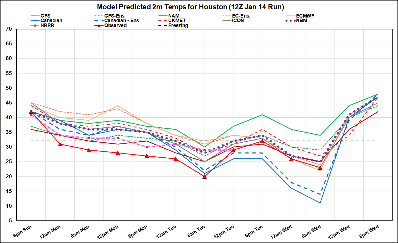

wxman57 wrote:Decided to look at the last model forecast before the front hit Sunday afternoon/evening. Black-bordered red triangles with red line are observed temps over central Houston (downtown). Every model performed badly, but HRRR and NAM were coldest, bringing the sub-freezing temps in MUCH earlier . GFS and Euro operationals were the worst for the first 48 hrs. NBM was generally about 5-7F too warm until yesterday afternoon.
Canadian hit Tuesday's low almost exactly from 48 hrs out. However, it was the worst for this morning's low. It has been forecasting 9F for this morning in every run after 12Z Sunday, even yesterday's run. Euro did best 72 hours out. NBM was still 2F too warm for this morning. GFS was terrible for the whole event.
This morning's low at my house was only 24. It was 20 yesterday morning.
http://wxman57.com/images/Verify.png
CaptinCrunch wrote:wxman57 wrote:Decided to look at the last model forecast before the front hit Sunday afternoon/evening. Black-bordered red triangles with red line are observed temps over central Houston (downtown). Every model performed badly, but HRRR and NAM were coldest, bringing the sub-freezing temps in MUCH earlier . GFS and Euro operationals were the worst for the first 48 hrs. NBM was generally about 5-7F too warm until yesterday afternoon.
Canadian hit Tuesday's low almost exactly from 48 hrs out. However, it was the worst for this morning's low. It has been forecasting 9F for this morning in every run after 12Z Sunday, even yesterday's run. Euro did best 72 hours out. NBM was still 2F too warm for this morning. GFS was terrible for the whole event.
This morning's low at my house was only 24. It was 20 yesterday morning.
http://wxman57.com/images/Verify.png
Thank you,
That is a perfect example of how NO model is perfect and you cannot discount certain models over the heavily favored ones because they appear incorrect. Data is data, and data IS NEVER 100% accurate regardless of it's modeling.
Weather forecasting is a crap shoot, no matter what, you just roll with what you got and hope for the best.
Iceresistance wrote:Tammie wrote:Area Forecast Discussion
Issued by NWS Oklahoma City, OK
.LONG TERM...
(Thursday through Tuesday)
Issued at 214 AM CST Wed Jan 17 2024
A northerly wind will return to all areas during the day Thursday as the surface low moves into southeastern Oklahoma by afternoon Thursday.
Bitterly cold air over western Canada will again move southward into the southern Plains. The arrival of the cold air will be northern Oklahoma early Thursday evening with the cold air overspreading the rest of Oklahoma and northern Texas during the late evening and overnight hours. Strong cold advection should result in some 35 to 40 mph winds with the initial surge of cold air, and a northerly wind will remain gusty well into the morning hours Friday. There is a medium chance (40-60%) of a Wind Chill advisory for the northern half of Oklahoma, as wind chill values will fall below -5 F.
The associated surface high with this cold air intrusion will build north and east of the area during the early part of the weekend. This will certainly keep temperatures on the cold side.
By late Sunday, precipitation chances will increase as a trough approaches the southern Plains from the west and southwest. Circulation of dry air will continue into Oklahoma and north Texas at this time. Therefore, there is a chance (30-40%) of freezing rain being the main precipitation type overnight Sunday into early Monday morning (some wet bulb influences) . At this time, it
appears areas along and southeast of I-44 have the best chance of experiencing precip chances are highest, there is a chance that temperatures could remain cooler and remain in the mid to upper 30s.
I really hope there is no ice storm.
Gotwood wrote:Iceresistance wrote:Tammie wrote:Area Forecast Discussion
Issued by NWS Oklahoma City, OK
.LONG TERM...
(Thursday through Tuesday)
Issued at 214 AM CST Wed Jan 17 2024
A northerly wind will return to all areas during the day Thursday as the surface low moves into southeastern Oklahoma by afternoon Thursday.
Bitterly cold air over western Canada will again move southward into the southern Plains. The arrival of the cold air will be northern Oklahoma early Thursday evening with the cold air overspreading the rest of Oklahoma and northern Texas during the late evening and overnight hours. Strong cold advection should result in some 35 to 40 mph winds with the initial surge of cold air, and a northerly wind will remain gusty well into the morning hours Friday. There is a medium chance (40-60%) of a Wind Chill advisory for the northern half of Oklahoma, as wind chill values will fall below -5 F.
The associated surface high with this cold air intrusion will build north and east of the area during the early part of the weekend. This will certainly keep temperatures on the cold side.
By late Sunday, precipitation chances will increase as a trough approaches the southern Plains from the west and southwest. Circulation of dry air will continue into Oklahoma and north Texas at this time. Therefore, there is a chance (30-40%) of freezing rain being the main precipitation type overnight Sunday into early Monday morning (some wet bulb influences) . At this time, it
appears areas along and southeast of I-44 have the best chance of experiencing precip chances are highest, there is a chance that temperatures could remain cooler and remain in the mid to upper 30s.
I really hope there is no ice storm.
Even if there is some ice it seems like it will melt very quickly so I doubt there will be many issues.
Harp.1 wrote:Ok, my Texas neighbors, what’s next??
Cpv17 wrote:Harp.1 wrote:Ok, my Texas neighbors, what’s next??
More cold Friday through Sunday and then a warm up and a flood next week.
Users browsing this forum: Stratton23, wxman22 and 49 guests


