2021 Indicators: SST's / SAL / MSLP / Shear / Steering / Instability / Sat Images

This is the general tropical discussion area. Anyone can take their shot at predicting a storms path.

Moderator: S2k Moderators

Forum rules

The posts in this forum are NOT official forecasts and should not be used as such. They are just the opinion of the poster and may or may not be backed by sound meteorological data. They are NOT endorsed by any professional institution or STORM2K. For official information, please refer to products from the National Hurricane Center and National Weather Service.

Help Support Storm2K
Message
Author
AlphaToOmega
Category 5
Category 5
Posts: 1448
Joined: Sat Jun 26, 2021 10:51 am
Location: Somewhere in Massachusetts

Re: 2021 Indicators: SST's / SAL / MSLP / Shear / Steering / Instability / Sat Images

#3061 Postby AlphaToOmega » Sun Sep 05, 2021 9:35 am

2018 September: seven storms
Image

2019 September: seven storms
Image

2020 September: ten storms
Image

What does this mean? It means that September has been super favorable for tropical cyclogenesis in the North Atlantic during both El Niño and La Niña years as of recent likely because of the African Standing Wave.

2021 September: who knows how many storms?
Image
Image

Based on these maps, we should see at least seven storms form in September 2021 at the bare minimum. One already formed: Larry. In my opinion, a realistic estimate would be ten storms à la 2020.
0 likes   

User avatar
Iceresistance
Category 5
Category 5
Posts: 9288
Age: 21
Joined: Sat Oct 10, 2020 9:45 am
Location: Tecumseh, OK/Norman, OK

Re: 2021 Indicators: SST's / SAL / MSLP / Shear / Steering / Instability / Sat Images

#3062 Postby Iceresistance » Sun Sep 05, 2021 9:37 am

The MJO is literally STUCK at Phases 2/3 & is expected to move into Phase 4 within the next several weeks . . .

Image
0 likes   
Bill 2015 & Beta 2020

Winter 2020-2021 :cold:

All observations are in Tecumseh, OK unless otherwise noted.

Winter posts are focused mainly for Oklahoma & Texas.

Take any of my forecasts with a grain of salt, refer to the NWS, SPC, and NHC for official information

Never say Never with weather! Because ANYTHING is possible!

User avatar
SFLcane
S2K Supporter
S2K Supporter
Posts: 10163
Age: 47
Joined: Sat Jun 05, 2010 1:44 pm
Location: Lake Worth Florida

Re: 2021 Indicators: SST's / SAL / MSLP / Shear / Steering / Instability / Sat Images

#3063 Postby SFLcane » Sun Sep 05, 2021 9:42 am

0 likes   

AlphaToOmega
Category 5
Category 5
Posts: 1448
Joined: Sat Jun 26, 2021 10:51 am
Location: Somewhere in Massachusetts

Re: 2021 Indicators: SST's / SAL / MSLP / Shear / Steering / Instability / Sat Images

#3064 Postby AlphaToOmega » Sun Sep 05, 2021 10:29 am

I think we may be tracking storms into December. A La Niña should help lower wind shear in the Atlantic basin, and we are overdue for a December storm. Emphasis on may
0 likes   

User avatar
CyclonicFury
Category 5
Category 5
Posts: 2025
Age: 26
Joined: Sun Jul 02, 2017 12:32 pm
Location: NC
Contact:

Re: 2021 Indicators: SST's / SAL / MSLP / Shear / Steering / Instability / Sat Images

#3065 Postby CyclonicFury » Sun Sep 05, 2021 10:40 am

AlphaToOmega wrote:I think we may be tracking storms into December. A La Niña should help lower wind shear in the Atlantic basin, and we are overdue for a December storm. Emphasis on may

December activity is quite random and difficult to predict. Despite 2017 and 2020 being hyperactive seasons, neither had any storms form in December. The majority of December storms are over the eastern subtropical Atlantic, or less commonly, the Caribbean, and typically do not get very strong. Most of them avoid land.
2 likes   
NCSU B.S. in Meteorology Class of 2021. Tropical weather blogger at http://www.cyclonicfury.com. My forecasts and thoughts are NOT official, for official forecasts please consult the National Hurricane Center.

User avatar
toad strangler
S2K Supporter
S2K Supporter
Posts: 4543
Joined: Sun Jul 28, 2013 3:09 pm
Location: Earth
Contact:

Re: 2021 Indicators: SST's / SAL / MSLP / Shear / Steering / Instability / Sat Images

#3066 Postby toad strangler » Sun Sep 05, 2021 10:50 am

I said it earlier and I'll say it again since the subject is at hand. Unless we get a very anomalous situation like we did one year ago, the season as far as threats to land in the WESTERN basin (and especially the CONUS) has another 55 days or so left. That's what climo says. Again, this is in a general climo historical sense. We'll see.. . we do have an inbound La Nina but that doesn't automatically mean late season storms.
2 likes   

User avatar
SFLcane
S2K Supporter
S2K Supporter
Posts: 10163
Age: 47
Joined: Sat Jun 05, 2010 1:44 pm
Location: Lake Worth Florida

Re: 2021 Indicators: SST's / SAL / MSLP / Shear / Steering / Instability / Sat Images

#3067 Postby SFLcane » Sun Sep 05, 2021 10:52 am

toad strangler wrote:I said it earlier and I'll say it again since the subject is at hand. Unless we get a very anomalous situation like we did one year ago, the season as far as threats to land in the WESTERN basin (and especially the CONUS) has another 55 days or so left. That's what climo says. Again, this is in a general climo historical sense. We'll see.. . we do have an inbound La Nina but that doesn't automatically mean late season storms.


+1
1 likes   

User avatar
toad strangler
S2K Supporter
S2K Supporter
Posts: 4543
Joined: Sun Jul 28, 2013 3:09 pm
Location: Earth
Contact:

Re: 2021 Indicators: SST's / SAL / MSLP / Shear / Steering / Instability / Sat Images

#3068 Postby toad strangler » Sun Sep 05, 2021 11:02 am

SFLcane wrote:
toad strangler wrote:I said it earlier and I'll say it again since the subject is at hand. Unless we get a very anomalous situation like we did one year ago, the season as far as threats to land in the WESTERN basin (and especially the CONUS) has another 55 days or so left. That's what climo says. Again, this is in a general climo historical sense. We'll see.. . we do have an inbound La Nina but that doesn't automatically mean late season storms.


+1


The central and southern FL peninsula is the last vestige of CONUS that would be favorable for a hit all the way through this period. As you are well aware. If W Caribbean genesis is still a thing late, we could have an issue.
4 likes   

User avatar
CyclonicFury
Category 5
Category 5
Posts: 2025
Age: 26
Joined: Sun Jul 02, 2017 12:32 pm
Location: NC
Contact:

Re: 2021 Indicators: SST's / SAL / MSLP / Shear / Steering / Instability / Sat Images

#3069 Postby CyclonicFury » Sun Sep 05, 2021 11:10 am

AlphaToOmega wrote:2018 September: seven storms
https://i.postimg.cc/8zJh5yzx/h6-YPRz-Vj-RK.png

2019 September: seven storms
https://i.postimg.cc/50M5Dw1T/s-DWa-Jk-T4e-T.png

2020 September: ten storms
https://i.postimg.cc/43Rh3sMh/Jg9890l2-Kp.png

What does this mean? It means that September has been super favorable for tropical cyclogenesis in the North Atlantic during both El Niño and La Niña years as of recent likely because of the African Standing Wave.

2021 September: who knows how many storms?
https://i.postimg.cc/prjmvSZB/cansips-chi200-global-1.png
https://i.postimg.cc/FFkd0f4J/cfs-mon-01-chi200-global-1.png

Based on these maps, we should see at least seven storms form in September 2021 at the bare minimum. One already formed: Larry. In my opinion, a realistic estimate would be ten storms à la 2020.

You have to look at more than just the last 3 years and more of a historical perspective. It's not that uncommon for September in active seasons to only have 3-4 storms, usually quality storms, in years where August was very active like 2021. September 2017, despite having more Atlantic ACE than any other month, only had 4 named storms form, including none after September 16. September 1995 only had 3 named storms form after an extremely active August, but all of the storms that formed were hurricanes. September 2004 was also significantly less active than August. I'd expect to see another 1-3 storms around the middle of the month when a weak CCKW passes through, but overall the MJO pattern doesn't look to be all that conducive for the rest of September. IMO September is more likely to finish with 3-5 storms than 7-10, but the quality of the storms that do form might be stronger than 2020. 2020 having 10 named storms in September set a record, I don't think we'll get that many this year.
6 likes   
NCSU B.S. in Meteorology Class of 2021. Tropical weather blogger at http://www.cyclonicfury.com. My forecasts and thoughts are NOT official, for official forecasts please consult the National Hurricane Center.

User avatar
cycloneye
Admin
Admin
Posts: 145327
Age: 68
Joined: Thu Oct 10, 2002 10:54 am
Location: San Juan, Puerto Rico

Re: 2021 Indicators: SST's / SAL / MSLP / Shear / Steering / Instability / Sat Images

#3070 Postby cycloneye » Sun Sep 05, 2021 11:32 am

SFLcane wrote:Quite sept how about no.

https://twitter.com/webberweather/statu ... 6302970882?


There is always a twit. Dr Ventrice failed bigtime in 2017 and I would have be gone from twitter after that. Hello José, Irma and Maria.

Image
11 likes   
Visit the Caribbean-Central America Weather Thread where you can find at first post web cams,radars
and observations from Caribbean basin members Click Here

User avatar
toad strangler
S2K Supporter
S2K Supporter
Posts: 4543
Joined: Sun Jul 28, 2013 3:09 pm
Location: Earth
Contact:

Re: 2021 Indicators: SST's / SAL / MSLP / Shear / Steering / Instability / Sat Images

#3071 Postby toad strangler » Sun Sep 05, 2021 11:35 am

cycloneye wrote:
SFLcane wrote:Quite sept how about no.

https://twitter.com/webberweather/statu ... 6302970882?


There is always a twit. Dr Ventrice failed bigtime in 2017 and I would have be gone from twitter after that. Hello José, Irma and Maria.

https://i.imgur.com/QC8Zv3R.png


W O W :eek:
0 likes   

User avatar
SFLcane
S2K Supporter
S2K Supporter
Posts: 10163
Age: 47
Joined: Sat Jun 05, 2010 1:44 pm
Location: Lake Worth Florida

Re: 2021 Indicators: SST's / SAL / MSLP / Shear / Steering / Instability / Sat Images

#3072 Postby SFLcane » Sun Sep 05, 2021 11:44 am

cycloneye wrote:
SFLcane wrote:Quite sept how about no.

https://twitter.com/webberweather/statu ... 6302970882?


There is always a twit. Dr Ventrice failed bigtime in 2017 and I would have be gone from twitter after that. Hello José, Irma and Maria.

https://i.imgur.com/QC8Zv3R.png


Oops! :roll:
0 likes   

AlphaToOmega
Category 5
Category 5
Posts: 1448
Joined: Sat Jun 26, 2021 10:51 am
Location: Somewhere in Massachusetts

Re: 2021 Indicators: SST's / SAL / MSLP / Shear / Steering / Instability / Sat Images

#3073 Postby AlphaToOmega » Sun Sep 05, 2021 11:52 am

CyclonicFury wrote:
AlphaToOmega wrote:2018 September: seven storms
https://i.postimg.cc/8zJh5yzx/h6-YPRz-Vj-RK.png

2019 September: seven storms
https://i.postimg.cc/50M5Dw1T/s-DWa-Jk-T4e-T.png

2020 September: ten storms
https://i.postimg.cc/43Rh3sMh/Jg9890l2-Kp.png

What does this mean? It means that September has been super favorable for tropical cyclogenesis in the North Atlantic during both El Niño and La Niña years as of recent likely because of the African Standing Wave.

2021 September: who knows how many storms?
https://i.postimg.cc/prjmvSZB/cansips-chi200-global-1.png
https://i.postimg.cc/FFkd0f4J/cfs-mon-01-chi200-global-1.png

Based on these maps, we should see at least seven storms form in September 2021 at the bare minimum. One already formed: Larry. In my opinion, a realistic estimate would be ten storms à la 2020.

You have to look at more than just the last 3 years and more of a historical perspective. It's not that uncommon for September in active seasons to only have 3-4 storms, usually quality storms, in years where August was very active like 2021. September 2017, despite having more Atlantic ACE than any other month, only had 4 named storms form, including none after September 16. September 1995 only had 3 named storms form after an extremely active August, but all of the storms that formed were hurricanes. September 2004 was also significantly less active than August. I'd expect to see another 1-3 storms around the middle of the month when a weak CCKW passes through, but overall the MJO pattern doesn't look to be all that conducive for the rest of September. IMO September is more likely to finish with 3-5 storms than 7-10, but the quality of the storms that do form might be stronger than 2020. 2020 having 10 named storms in September set a record, I don't think we'll get that many this year.


The VP anomaly pattern forecasted by both the CanSIPS and CFSv2 for September 2021 quite closely matches September 2020. The ECMWF also suggests an African Standing Wave during September 2021. MJO is not a big factor during the peak season. The African Standing Wave, which was seen in 2018, 2019, and 2020, is likely to make September 2021 very active.
2 likes   

User avatar
SFLcane
S2K Supporter
S2K Supporter
Posts: 10163
Age: 47
Joined: Sat Jun 05, 2010 1:44 pm
Location: Lake Worth Florida

Re: 2021 Indicators: SST's / SAL / MSLP / Shear / Steering / Instability / Sat Images

#3074 Postby SFLcane » Sun Sep 05, 2021 11:54 am

Might have another screen shot in a few weeks. :wink:
0 likes   

User avatar
gatorcane
S2K Supporter
S2K Supporter
Posts: 23691
Age: 47
Joined: Sun Mar 13, 2005 3:54 pm
Location: Boca Raton, FL

Re: 2021 Indicators: SST's / SAL / MSLP / Shear / Steering / Instability / Sat Images

#3075 Postby gatorcane » Sun Sep 05, 2021 11:55 am

toad strangler wrote:
SFLcane wrote:
toad strangler wrote:I said it earlier and I'll say it again since the subject is at hand. Unless we get a very anomalous situation like we did one year ago, the season as far as threats to land in the WESTERN basin (and especially the CONUS) has another 55 days or so left. That's what climo says. Again, this is in a general climo historical sense. We'll see.. . we do have an inbound La Nina but that doesn't automatically mean late season storms.


+1


The central and southern FL peninsula is the last vestige of CONUS that would be favorable for a hit all the way through this period. As you are well aware. If W Caribbean genesis is still a thing late, we could have an issue.


South Florida’s month for most cyclone hits from a climatological perspective is is October so it will be again a month to watch this year given La Niña. Somehow since 2005, South Florida has managed to escape a hit from a Caribbean hurricane. Those cyclones that have formed seem to impact the panhandle, or northern Gulf as well as Central America with stout ridging that has setup over the Bahamas preventing a N NE ejection out of the Caribbean.
1 likes   

IcyTundra
Category 5
Category 5
Posts: 1205
Joined: Mon Jun 07, 2021 9:32 pm
Location: Dickinson, Texas

2021 Global Model Runs Discussion (Out thru day 16)

#3076 Postby IcyTundra » Sun Sep 05, 2021 12:07 pm

I highly doubt September will be as inactive as some models are suggesting. It is the peak of hurricane season climatologically and there is a favorable base state with a transition to a La Nina from ENSO cool-neutral expected sometime soon.
0 likes   

AlphaToOmega
Category 5
Category 5
Posts: 1448
Joined: Sat Jun 26, 2021 10:51 am
Location: Somewhere in Massachusetts

Re: 2021 Indicators: SST's / SAL / MSLP / Shear / Steering / Instability / Sat Images

#3077 Postby AlphaToOmega » Sun Sep 05, 2021 12:17 pm

Nail in the coffin for bearish predictions for September
Image
Image
0 likes   

jconsor
Professional-Met
Professional-Met
Posts: 551
Joined: Mon Jun 30, 2008 9:31 pm
Location: Jerusalem, Israel
Contact:

Re: 2021 Indicators: SST's / SAL / MSLP / Shear / Steering / Instability / Sat Images

#3078 Postby jconsor » Sun Sep 05, 2021 1:07 pm

4 likes   

AlphaToOmega
Category 5
Category 5
Posts: 1448
Joined: Sat Jun 26, 2021 10:51 am
Location: Somewhere in Massachusetts

Re: 2021 Indicators: SST's / SAL / MSLP / Shear / Steering / Instability / Sat Images

#3079 Postby AlphaToOmega » Sun Sep 05, 2021 2:55 pm


That looks like a standing wave over Africa to me! September is going to feature many storms simply due to the African Standing Wave. I need to see a scenario in which a below-average September can be achieved with an African Standing Wave.
0 likes   

AlphaToOmega
Category 5
Category 5
Posts: 1448
Joined: Sat Jun 26, 2021 10:51 am
Location: Somewhere in Massachusetts

Re: 2021 Indicators: SST's / SAL / MSLP / Shear / Steering / Instability / Sat Images

#3080 Postby AlphaToOmega » Sun Sep 05, 2021 3:54 pm

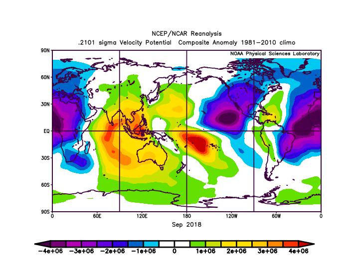
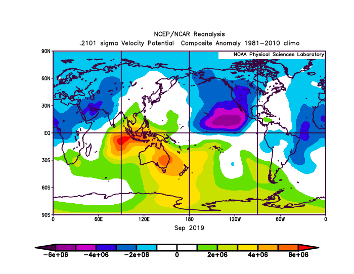
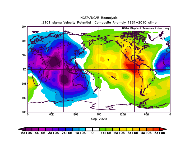
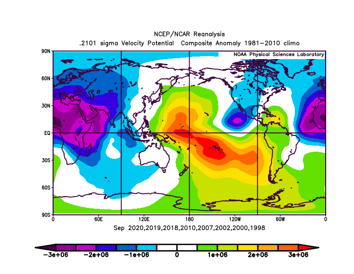
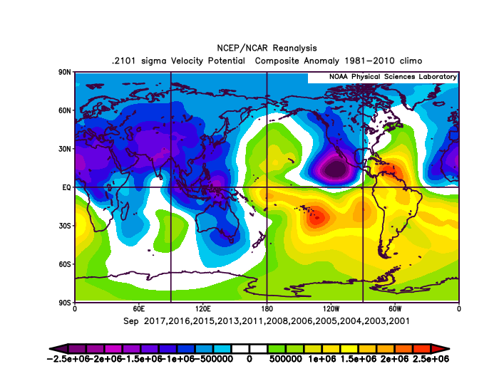
I split every September from 1997 to 2020 into three categories: above-average, average, and below-average. An above-average September features seven or more storms. An average September features four to six storms. A below-average September features three or fewer storms.

Above-average September:
Image

Average September:
Image

Below-average September:
Image

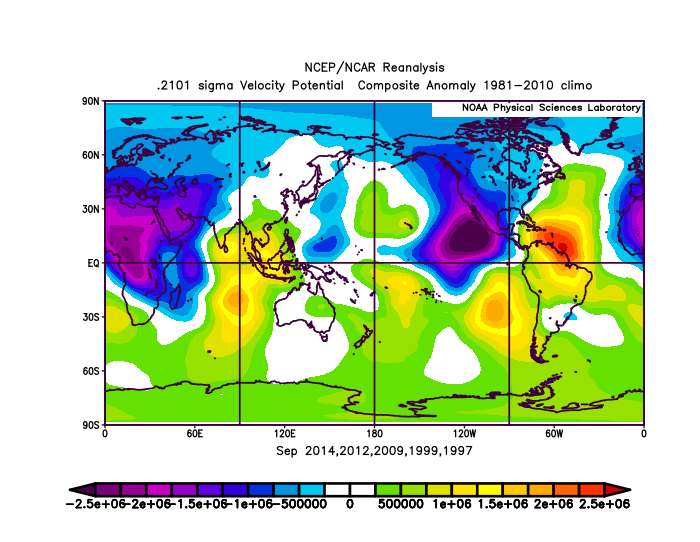
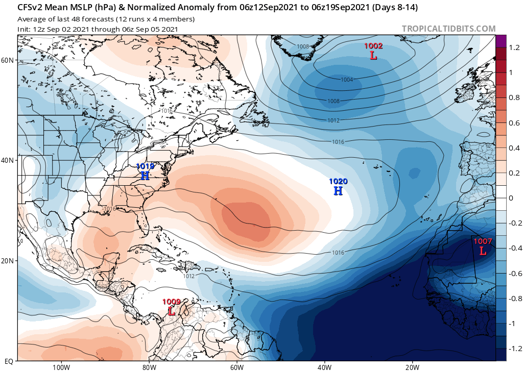
There is one key difference between the above-average Septembers, the average Septembers, and the below-average Septembers: the VP anomalies in the Indian Ocean. For above-average Septembers, VP anomalies in the Indian Ocean are consistently negative. For average Septembers, VP anomalies in the Indian Ocean are negative in some parts and positive in other parts. For below-average Septembers, VP anomalies in the Indian Ocean are consistently positive. What will September 2021 likely feature?

Image
Image
Image

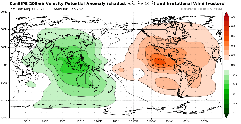
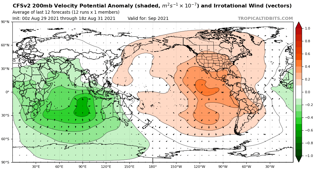
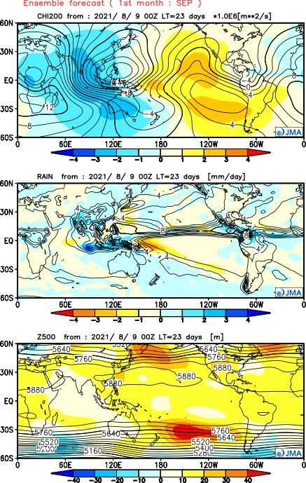
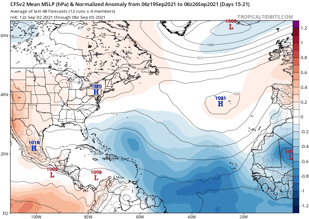
This matches with an above-average September (seven or more storms) signature. The CanSIPS, CFSv2, and JMA would all have to bust in a major way for September 2021 to have fewer than seven storms.
3 likes   


Return to “Talkin' Tropics”

Who is online

Users browsing this forum: Cpv17, Google Adsense [Bot], JtSmarts, Tx_Summer, wwizard and 22 guests