Texas Winter 2025-2026
Moderator: S2k Moderators
Forum rules
 The posts in this forum are NOT official forecast and should not be used as such. They are just the opinion of the poster and may or may not be backed by sound meteorological data. They are NOT endorsed by any professional institution or STORM2K.

The posts in this forum are NOT official forecast and should not be used as such. They are just the opinion of the poster and may or may not be backed by sound meteorological data. They are NOT endorsed by any professional institution or STORM2K.


-
Tireman4

- S2K Supporter

- Posts: 5903
- Age: 60
- Joined: Fri Jun 30, 2006 1:08 pm
- Location: Humble, Texas
- Contact:
Re: Texas Winter 2025-2026
Gotwood wrote:Quixotic wrote:Speaking of sampling, I imagine that will happen Thursday?
Think a poster said tomorrow
Yes, the Austin Man and yes, tomorrow.
2 likes
-
orangeblood
- S2K Supporter
- Posts: 3895
- Joined: Tue Dec 15, 2009 6:14 pm
- Location: Fort Worth, TX
Re: Texas Winter 2025-2026
snownado wrote:Ralph's Weather wrote:I do not love seeing the NAM as warm as it is at the end of its run with that much of a warm nose. That's more of a prolonged period of freezing rain than I would prefer.
If we can keep the air temps in the 30-32*F range as it shows, we should avoid significant icing as the rain will struggle with accretion on the antecedent warm surfaces.
This post is a bit misleading IMO...this only goes out to midnight Friday night, the system is just getting started at that time - only the 2nd/3rd inning. It will get significantly colder as the system progresses out of Baja overnight on Friday and into late Saturday
6 likes
Re: Texas Winter 2025-2026
rwfromkansas wrote:Quixotic wrote:bevolon wrote:
I hope it's not a jinx!!!!!???
Just remember not to get too giddy and not to get too low.
Wise advice, which is why I am trying not to get one run get me too worried. Even the high-res models sometimes have goofy runs. Granted I don't want a massive ice storm here either.
Brother, you and me both. Freezing rain sucks. Giant sleet storms are almost as bad. FWD has me in the mostly snow area. Hope it holds.
0 likes
-
Ralph's Weather
- S2K Supporter
- Posts: 3371
- Age: 38
- Joined: Fri Dec 13, 2013 11:55 am
- Location: Lindale, TX
- Contact:
Re: Texas Winter 2025-2026
orangeblood wrote:snownado wrote:Ralph's Weather wrote:I do not love seeing the NAM as warm as it is at the end of its run with that much of a warm nose. That's more of a prolonged period of freezing rain than I would prefer.
If we can keep the air temps in the 30-32*F range as it shows, we should avoid significant icing as the rain will struggle with accretion on the antecedent warm surfaces.
This post is a bit misleading IMO...this only goes out to midnight Friday night, the system is just getting started at that time - only the 2nd/3rd inning. It will get significantly colder as the system progresses out of Baja overnight on Friday and into late Saturday
Agreed but was holding out hope to not have a base of significant freezing rain before the real even begins on Saturday. Though if it holds above 28 or so that freezing rain will not be a major travel issue for for Friday evening which would be very beneficial.
2 likes
Follow on Facebook at Ralph's Weather.
-
orangeblood
- S2K Supporter
- Posts: 3895
- Joined: Tue Dec 15, 2009 6:14 pm
- Location: Fort Worth, TX
Re: Texas Winter 2025-2026
HockeyTx82 wrote:Did we get NAM'ed?
No, not in Texas. Oklahoma maybe a different story if the NAM is onto something, much more suppressed with qpf shield. But I don't really trust the NAM precip output at this range...
7 likes
-
wxman57

- Moderator-Pro Met

- Posts: 23172
- Age: 68
- Joined: Sat Jun 21, 2003 8:06 pm
- Location: Houston, TX (southwest)
Re: Texas Winter 2025-2026
HockeyTx82 wrote:wxman57 wrote:Here are all the model forecasts for Houston. Note the Canadian is the extreme outlier, as it always is here with such events. Discard it immediately. UKMET (gray line) is way too warm at the start, too cold in the middle, and too warm at the end of the graphic. National Blend of Models (NBM) has Houston below freezing from 3am Sunday to 12pm Monday. Note that these are 6hr data points, meaning no 21Z points, so it's possible the temperature could be a deg or two higher in mid afternoon. NBM has an inch or two of snow in D-FW area and about a tenth of an inch of freezing rain here in Houston. I suspect elevated roads will become icy in Houston Saturday evening. I'm not seeing enough freezing rain for power outages yet, but I wouldn't rule out 1/4" of freezing rain or more here. I'll be nice and warm with my generator running if there is a power outage. No need to fly to Australia this time.
https://wxman57.com/images/12ZJan20Models.jpg
https://wxman57.com/images/12ZJan20Models.jpg
Wait so DFW has trended down in totals now?
That depends on what model you're looking at. It's too early to be confident of anything. D-FW could see anywhere from 1-2 inches to 8-10 inches.
5 likes
Re: Texas Winter 2025-2026
orangeblood wrote:snownado wrote:Ralph's Weather wrote:I do not love seeing the NAM as warm as it is at the end of its run with that much of a warm nose. That's more of a prolonged period of freezing rain than I would prefer.
If we can keep the air temps in the 30-32*F range as it shows, we should avoid significant icing as the rain will struggle with accretion on the antecedent warm surfaces.
This post is a bit misleading IMO...this only goes out to midnight Friday night, the system is just getting started at that time - only the 2nd/3rd inning. It will get significantly colder as the system progresses out of Baja overnight on Friday and into late Saturday
Yeah this isn’t like last year. We have serious cold coming down.
5 likes
-
orangeblood
- S2K Supporter
- Posts: 3895
- Joined: Tue Dec 15, 2009 6:14 pm
- Location: Fort Worth, TX
Re: Texas Winter 2025-2026
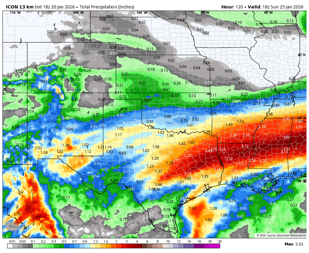
ICON also much more suppressed with QPF shield across Oklahoma, a trend that may have some traction particularly as the models latch onto how strong the Arctic HP is
2 likes
-
HockeyTx82
- S2K Supporter
- Posts: 2790
- Joined: Tue Oct 27, 2009 11:17 am
- Location: Ponder, TX
Re: Texas Winter 2025-2026
orangeblood wrote:ICON also much more suppressed with QPF shield across Oklahoma, a trend that may have some traction particularly as the models latch onto how strong the Arctic HP is
https://images.weatherbell.com/model/icon-all/scentus/total_precip_inch/1768932000/1769364000-cB9W5IPMZbE.png
Can't have both, can we......
2 likes
Don't hold me accountable for anything I post on this forum. Leave the real forecasting up to the professionals.
Location: Ponder, TX (all observation posts are this location unless otherwise noted)
Location: Ponder, TX (all observation posts are this location unless otherwise noted)
-
orangeblood
- S2K Supporter
- Posts: 3895
- Joined: Tue Dec 15, 2009 6:14 pm
- Location: Fort Worth, TX
Re: Texas Winter 2025-2026
HockeyTx82 wrote:orangeblood wrote:ICON also much more suppressed with QPF shield across Oklahoma, a trend that may have some traction particularly as the models latch onto how strong the Arctic HP is
https://images.weatherbell.com/model/icon-all/scentus/total_precip_inch/1768932000/1769364000-cB9W5IPMZbE.png
Can't have both, can we......
North Texas is still ground zero and ICON has actually increased totals there. It's Oklahoma particularly N/2 could be undercut quite a bit from earlier depictions
2 likes
-
Iceresistance

- Category 5

- Posts: 9579
- Age: 22
- Joined: Sat Oct 10, 2020 9:45 am
- Location: Tecumseh, OK/Norman, OK
Re: Texas Winter 2025-2026
orangeblood wrote:ICON also much more suppressed with QPF shield across Oklahoma, a trend that may have some traction particularly as the models latch onto how strong the Arctic HP is
https://images.weatherbell.com/model/icon-all/scentus/total_precip_inch/1768932000/1769364000-cB9W5IPMZbE.png
I did see chatter that the models can't figure out the Baja low, so expect the back and forth runs to go for a while
0 likes
Bill 2015 & Beta 2020
Winter 2020-2021
All observations are in Tecumseh, OK unless otherwise noted.
Winter posts are focused mainly for Oklahoma & Texas.
Take any of my forecasts with a grain of salt, refer to the NWS, SPC, and NHC for official information
Never say Never with weather! Because ANYTHING is possible!
Winter 2020-2021
All observations are in Tecumseh, OK unless otherwise noted.
Winter posts are focused mainly for Oklahoma & Texas.
Take any of my forecasts with a grain of salt, refer to the NWS, SPC, and NHC for official information
Never say Never with weather! Because ANYTHING is possible!
-
jaguars_22
- Category 2

- Posts: 629
- Joined: Tue Jun 20, 2017 2:26 pm
- Location: Victoria TX
Re: Texas Winter 2025-2026
A lot of this moisture is going to be coming out of Mexico! So not well modeled correct? So no model is going to be correct on amounts? Man I just wish the cold would come in sooner so it would be all of Texas seeing sleet and snow
5 likes
Re: Texas Winter 2025-2026
Looking aloft, I can immediately see what's causing the difference on the 18z NAM / RGEM vs. the GFS and ICON.
The STJ is much quicker to phase with the polar jet on the NAM / RGEM, which is pumping up the heights and thus leading to stronger cyclonegenesis in the RGV. That also limits the extent of cold air advection from the NE as the wind field responds by settling out of the E/SE for an extended period versus the N/NE.
18z ICON is closer to the EURO solution (which seems to be the middle ground right now).
Gotta love threading the needle...
2 likes
Re: Texas Winter 2025-2026
wxman57 wrote:Here are all the model forecasts for Houston. Note the Canadian is the extreme outlier, as it always is here with such events. Discard it immediately. UKMET (gray line) is way too warm at the start, too cold in the middle, and too warm at the end of the graphic. National Blend of Models (NBM) has Houston below freezing from 3am Sunday to 12pm Monday. Note that these are 6hr data points, meaning no 21Z points, so it's possible the temperature could be a deg or two higher in mid afternoon. NBM has an inch or two of snow in D-FW area and about a tenth of an inch of freezing rain here in Houston. I suspect elevated roads will become icy in Houston Saturday evening. I'm not seeing enough freezing rain for power outages yet, but I wouldn't rule out 1/4" of freezing rain or more here. I'll be nice and warm with my generator running if there is a power outage. No need to fly to Australia this time.
https://wxman57.com/images/12ZJan20Models.jpg
https://wxman57.com/images/12ZJan20Models.jpg
If Houston metro received a 1/10 in of freezing rain as mentioned above, would you expect far northern Harris and southern Montgomery to receive appreciably more than that, or close to the same?
0 likes
Any forecast I make is based on my opinion only. Please refer to the NWS or NHC for official forecasts.
-
bubba hotep

- S2K Supporter
- Posts: 6013
- Joined: Wed Dec 28, 2016 1:00 am
- Location: Collin County Texas
Re: Texas Winter 2025-2026
orangeblood wrote:HockeyTx82 wrote:Did we get NAM'ed?
No, not in Texas. Oklahoma maybe a different story if the NAM is onto something, much more suppressed with qpf shield. But I don't really trust the NAM precip output at this range...
Things I don't put any stock in - The Cowboys & the low res-NAM
9 likes
Winter time post are almost exclusively focused on the DFW area.

Re: Texas Winter 2025-2026
bubba hotep wrote:
Things I don't put any stock in - The Cowboys & the low res-NAM
Have you ever seen both of them in the same room at the same time? Didn't think so.
2 likes
The above post and any post by dhweather is NOT an official forecast and should not be used as such. It is just the opinion of the poster and may or may not be backed by sound meteorological data. It is NOT endorsed by any professional institution including storm2k.org. For official information, please refer to NWS products.
-
txtwister78

- Category 5
- Posts: 2169
- Joined: Wed Jan 30, 2019 12:56 pm
- Location: San Antonio
Re: Texas Winter 2025-2026
18z GFS trending colder and again advancing the arctic air deeper into Texas faster with your freeze line approaching northern Bexar by midnight Saturday morning dropping from there.
6 likes
-
cheezyWXguy

- Category 5
- Posts: 6282
- Joined: Mon Feb 13, 2006 12:29 am
- Location: Dallas, TX
Re: Texas Winter 2025-2026
The event is only just getting into the range of the NAM 12k, it’s only seeing about 6 hours into what could be a 24hr+ event. By its standards, it’s out in lala land right now. It is better at handling surface temps than the gfs, but only once the we get into range of the NAM 3k (<60hr). It’s common to see fluctuations on the model during this time, followed by dialing in during the final 2 days leading up to the event.
Also, it has a tendency to overdo the urban heat island effect, even more than the gfs, so that should be taken into account for us city slickers across the state trying to decipher precip types or surface temps in metro areas vs surrounding areas.
Also, it has a tendency to overdo the urban heat island effect, even more than the gfs, so that should be taken into account for us city slickers across the state trying to decipher precip types or surface temps in metro areas vs surrounding areas.
Last edited by cheezyWXguy on Tue Jan 20, 2026 5:05 pm, edited 1 time in total.
4 likes


Re: Texas Winter 2025-2026
Don't see a forecast like this everyday around these parts. Remember we went a quarter century without a single digit temp up until 2021?
DFW
DFW
Friday: Rain showers likely before noon, then rain showers, possibly mixed with sleet. Temperature falling to around 33 by 4pm. Northeast wind 10 to 15 mph, with gusts as high as 25 mph. Chance of precipitation is 80%.
Friday Night: Rain showers, freezing rain, and sleet before midnight, then sleet, possibly mixed with freezing rain. The sleet could be heavy at times. Low around 20. Northeast wind 10 to 15 mph, with gusts as high as 20 mph. Chance of precipitation is 90%.
Saturday: Sleet, possibly mixed with snow showers and freezing rain. The sleet could be heavy at times. High near 25. North wind around 15 mph, with gusts as high as 25 mph. Chance of precipitation is 90%.
Saturday Night: A chance of snow showers, freezing rain, and sleet. Mostly cloudy, with a low around 12. North wind around 10 mph, with gusts as high as 20 mph. Chance of precipitation is 40%.
Sunday: Partly sunny and cold, with a high near 25.
Sunday Night: Partly cloudy, with a low around 9.
Monday: Sunny, with a high near 32.
Monday Night: Partly cloudy, with a low around 18.
3 likes
The above post and any post by Ntxw is NOT an official forecast and should not be used as such. It is just the opinion of the poster and may or may not be backed by sound meteorological data. It is NOT endorsed by any professional institution including Storm2k. For official information, please refer to NWS products.
Help support Storm2K!
Who is online
Users browsing this forum: No registered users and 35 guests