
CPAC: LINDA - Post-Tropical
Moderator: S2k Moderators
-
Kingarabian

- S2K Supporter

- Posts: 16367
- Joined: Sat Aug 08, 2009 3:06 am
- Location: Honolulu, Hawaii
-
Kingarabian
- S2K Supporter
- Posts: 16367
- Joined: Sat Aug 08, 2009 3:06 am
- Location: Honolulu, Hawaii
Re: EPAC: LINDA - Hurricane update: Is Annular
Ptarmigan wrote:I notice East Pacific and West Pacific have more annular hurricanes than the Atlantic.
It would be nuts if the Atlantic could put out annular hurricanes as we all as the EPAC and WPAC. The only place for them to form is out over the MDR/EATL. But if they start to form, there would probably be more US threats.
0 likes
RIP Kobe Bryant
-
Yellow Evan

- Professional-Met

- Posts: 16241
- Age: 27
- Joined: Fri Jul 15, 2011 12:48 pm
- Location: Henderson, Nevada/Honolulu, HI
- Contact:

-
Kingarabian
- S2K Supporter
- Posts: 16367
- Joined: Sat Aug 08, 2009 3:06 am
- Location: Honolulu, Hawaii
Re: EPAC: LINDA - Hurricane
Eye still WMG, with the b ring coming back and thickening since its moving south and back over warmer waters. Could make it to T5.5 just in time for the next advisory.


4 likes
RIP Kobe Bryant
-
Yellow Evan
- Professional-Met
- Posts: 16241
- Age: 27
- Joined: Fri Jul 15, 2011 12:48 pm
- Location: Henderson, Nevada/Honolulu, HI
- Contact:
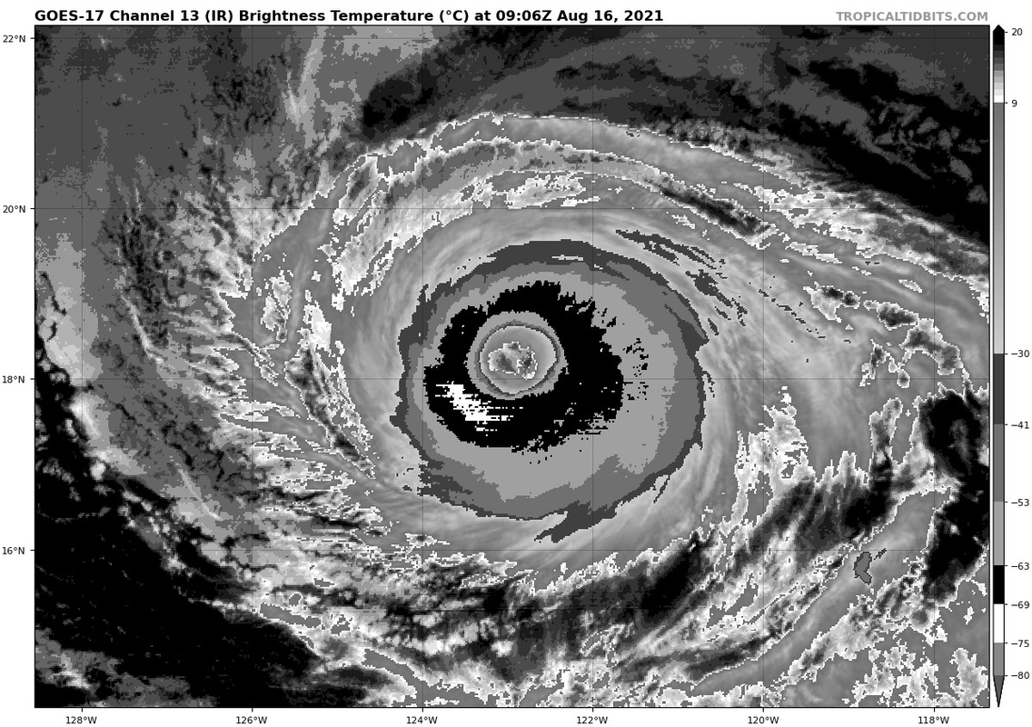
Re: EPAC: LINDA - Hurricane
TXPZ23 KNES 160551
TCSENP
A. 12E (LINDA)
B. 16/0530Z
C. 18.4N
D. 122.4W
E. TWO/GOES-W
F. T5.5/5.5
G. IR/EIR/SWIR
H. REMARKS...A WMG EYE SURROUNDED BY LG AND EMBEDDED IN LG YIELDS A DT
OF 5.5 AFTER AN EYE ADJ OF 0.5. MET AND PT ARE BOTH EQUAL TO 5.0 AFTER
A DEVELOPING SLOWLY TREND IN LAST 24 HOURS. FT IS BASED ON DT.
I. ADDL POSITIONS
NIL
...TUGGLE
Not sure I agree but not measuring.
0 likes
-
Sciencerocks
- Category 5

- Posts: 10186
- Age: 40
- Joined: Thu Jul 06, 2017 1:51 am

-
Yellow Evan
- Professional-Met
- Posts: 16241
- Age: 27
- Joined: Fri Jul 15, 2011 12:48 pm
- Location: Henderson, Nevada/Honolulu, HI
- Contact:

-
Yellow Evan
- Professional-Met
- Posts: 16241
- Age: 27
- Joined: Fri Jul 15, 2011 12:48 pm
- Location: Henderson, Nevada/Honolulu, HI
- Contact:
Re: EPAC: LINDA - Hurricane
This looks like Isabel during the end of its annular phase on September 14 2003 just with a smaller CDO but with the exact same eye structure.
3 likes

Re: EPAC: LINDA - Hurricane
In that graphic Kingarabian posted Linda is really riding along the 26C isotherm.
The 26C isotherm is looking at Linda like “I put my hand up on your hip, when I dip, you dip, we dip!”
The 26C isotherm is looking at Linda like “I put my hand up on your hip, when I dip, you dip, we dip!”
5 likes
Solar Aquarian
Lunar Cancerian
 Sagittarian
Lunar Cancerian
-
cycloneye

- Admin

- Posts: 149515
- Age: 69
- Joined: Thu Oct 10, 2002 10:54 am
- Location: San Juan, Puerto Rico
Re: EPAC: LINDA - Hurricane
Hurricane Linda Discussion Number 25
NWS National Hurricane Center Miami FL EP122021
1100 PM HST Sun Aug 15 2021
Linda's satellite presentation continues to be an excellent example
of an annular hurricane with the classic doughnut shape. The
cloud pattern consists of a +14C warm eye and a deep convective
inner-core while lacking banding features. The Annular Hurricane
Index (AHI), which is included in the SHIPS intensity output,
calculated an AHI of 75 out of 100, with and AHI of 100 being best
fit to annular structure. Although the inner ring's cloud tops
have cooled a bit in the south quadrant (-67C), the northwest
portion of the eyewall has thinned out. It appears as though
some dry air is beginning to impinge on this part of the hurricane.
As a result, the objective and subjective satellite intensity
estimates have decreased and support lowering the initial intensity
to 90 kt for this advisory.
Through Wednesday morning, only steady weakening is forecast as
Linda remains over marginal (26C) sea surface temperatures and in a
low wind shear environment. Beyond the 60 hour period, Linda will
move over a steep sea-surface temperature gradient (sub -24C) and
enter a dry more stable marine layer which should cause the
hurricane to weaken more quickly through day 5. The NHC intensity
forecast continues to follow the Decay-SHIPS model through 60
hours, then uses a blend of the global models and the IVCN/HCCA
consensus aids which show Linda becoming a post-tropical cyclone
Friday night.
The initial motion estimate is west-southwestward, or 250/9 kt,
There is, once again, little change to the track forecast
philosophy as strengthening mid-tropospheric high pressure over the
northeastern Pacific steers Linda west-southwestward to westward
through the 36 hour period. Afterward, a turn toward the
west-northwest is expected as Linda rounds the southwestern
periphery of the aforementioned ridge. The NHC forecast follows
the previous one closely and is in good agreement with the latest
dynamical model consensus, TVCN.
A 0338 and a 0454 UTC METOP-A and B scatterometer pass indicated
that Linda's wind radii had expanded a little in the west
semicircle, and adjustments were made, accordingly.
FORECAST POSITIONS AND MAX WINDS
INIT 16/0900Z 18.2N 122.9W 90 KT 105 MPH
12H 16/1800Z 17.7N 124.2W 90 KT 105 MPH
24H 17/0600Z 17.5N 125.8W 85 KT 100 MPH
36H 17/1800Z 17.7N 127.6W 80 KT 90 MPH
48H 18/0600Z 18.2N 129.8W 75 KT 85 MPH
60H 18/1800Z 19.0N 132.1W 65 KT 75 MPH
72H 19/0600Z 19.9N 134.7W 60 KT 70 MPH
96H 20/0600Z 21.5N 140.0W 50 KT 60 MPH
120H 21/0600Z 22.6N 145.0W 40 KT 45 MPH...POST-TROPICAL
$$
Forecaster Roberts
0 likes
Visit the Caribbean-Central America Weather Thread where you can find at first post web cams,radars
and observations from Caribbean basin members Click Here
and observations from Caribbean basin members Click Here
-
Kingarabian
- S2K Supporter
- Posts: 16367
- Joined: Sat Aug 08, 2009 3:06 am
- Location: Honolulu, Hawaii
-
Yellow Evan
- Professional-Met
- Posts: 16241
- Age: 27
- Joined: Fri Jul 15, 2011 12:48 pm
- Location: Henderson, Nevada/Honolulu, HI
- Contact:
-
Blown Away

- S2K Supporter
- Posts: 10253
- Joined: Wed May 26, 2004 6:17 am
Re: EPAC: LINDA - Hurricane

That eye is stunning!
3 likes
Hurricane Eye Experience: David 79, Irene 99, Frances 04, Jeanne 04, Wilma 05… Hurricane Brush Experience: Andrew 92, Erin 95, Floyd 99, Matthew 16, Irma 17, Ian 22, Nicole 22…
-
Yellow Evan
- Professional-Met
- Posts: 16241
- Age: 27
- Joined: Fri Jul 15, 2011 12:48 pm
- Location: Henderson, Nevada/Honolulu, HI
- Contact:

-
Yellow Evan
- Professional-Met
- Posts: 16241
- Age: 27
- Joined: Fri Jul 15, 2011 12:48 pm
- Location: Henderson, Nevada/Honolulu, HI
- Contact:
Re: EPAC: LINDA - Hurricane
TXPZ23 KNES 161209
TCSENP
A. 12E (LINDA)
B. 16/1130Z
C. 18.0N
D. 123.3W
E. ONE/GOES-W
F. T5.5/5.5
G. IR/EIR/SWIR
H. REMARKS...SYSTEM HAS AN EXPANSIVE EYEWALL STRUCTURE. THE EYE TEMP
IS WMG, SURROUNDED BY LG RING TEMP AND IS EMBEDDED IN LG RESULTING IN AN
EYE PATTERN DT OF 5.5. THE 24 HR DEVELOPING TREND RESULTS IN DEVELOPING
SLOWLY. MET AND PT ARE 5.0. FT IS BASED ON DT.
I. ADDL POSITIONS
NIL
...PATEL
2 likes
-
tolakram
- Admin
- Posts: 20186
- Age: 62
- Joined: Sun Aug 27, 2006 8:23 pm
- Location: Florence, KY (name is Mark)
Re: EPAC: LINDA - Hurricane
Sunrise

adjusted

adjusted
7 likes
M a r k
- - - - -
Join us in chat: Storm2K Chatroom Invite. Android and IOS apps also available.
The posts in this forum are NOT official forecasts and should not be used as such. Posts are NOT endorsed by any professional institution or STORM2K.org. For official information and forecasts, please refer to NHC and NWS products.

Re: EPAC: LINDA - Hurricane
tolakram wrote:Sunrise
https://i.imgur.com/gFYKhNf.png
Now that is a beautiful hurricane photo, almost looks like a monster from deep in the ocean.
0 likes
-
cycloneye
- Admin
- Posts: 149515
- Age: 69
- Joined: Thu Oct 10, 2002 10:54 am
- Location: San Juan, Puerto Rico
Re: EPAC: LINDA - Hurricane
Hurricane Linda Discussion Number 26
NWS National Hurricane Center Miami FL EP122021
500 AM HST Mon Aug 16 2021
There has been little notable change in Linda's structure on
satellite imagery. The hurricane continues to possess annular
characteristics, with a well-defined warm eye up to +15 C
surrounded by a ring of -60 to -65 C cloud top temperatures
associated with the eyewall. The eyewall was also well-defined on a
recent 1003 UTC AMSR-2 microwave pass. The most recent subjective
Dvorak classifications from SAB and TAFB were T5.5/102 kt and
T5.0/90 kt, while the latest UW-CIMSS ADT estimate was T5.1/92 kt.
Thus, Linda is being maintained as a 90-kt hurricane for this
advisory, though this might be a bit on the conservative side.
The initial motion estimate continues off to the west-southeast, at
255/8 kt. The most recent track forecast is mostly just an update of
the previous one. Linda is expected to gradually make a rightward
turn from the west-southwest to the west-northwest as a strong
mid-level ridge to the north shifts its orientation. The latest NHC
track forecast remains is good agreement with the track consensus
guidance, blending the TVCN and HCCA aids.
Linda remains in a very low wind shear environment, with SHIPS
guidance diagnosing showing less than 5-kt of shear over the
hurricane currently. Even though sea-surface temperatures remain
only marginally warm along the Linda's forecast track, its
continued annular structure argues for only very gradual weakening
over the next 48 hours. Afterwards, Linda will cross over the 26 C
isotherm into cooler waters, and a faster rate of weakening is
anticipated after that time. The latest NHC intensity forecast over
the first couple of days remains higher than the majority of the
model guidance, and is closest to the ECMWF forecast. After Linda
begins to move over cooler waters in 60 h, the intensity forecast
is brought back down towards the intensity consensus. At the end of
the forecast period, Linda is expected to become a post-tropical
gale once deep organized convection ceases, as suggested by the GFS
and ECMWF simulated brightness temperature at that time frame.
FORECAST POSITIONS AND MAX WINDS
INIT 16/1500Z 17.9N 123.7W 90 KT 105 MPH
12H 17/0000Z 17.6N 124.9W 90 KT 105 MPH
24H 17/1200Z 17.5N 126.7W 85 KT 100 MPH
36H 18/0000Z 17.9N 128.6W 80 KT 90 MPH
48H 18/1200Z 18.5N 130.9W 75 KT 85 MPH
60H 19/0000Z 19.2N 133.4W 65 KT 75 MPH
72H 19/1200Z 20.1N 136.0W 60 KT 70 MPH
96H 20/1200Z 21.6N 141.3W 50 KT 60 MPH
120H 21/1200Z 22.6N 146.0W 40 KT 45 MPH...POST-TROPICAL
$$
Forecaster Papin/Brennan
0 likes
Visit the Caribbean-Central America Weather Thread where you can find at first post web cams,radars
and observations from Caribbean basin members Click Here
and observations from Caribbean basin members Click Here
-
tolakram
- Admin
- Posts: 20186
- Age: 62
- Joined: Sun Aug 27, 2006 8:23 pm
- Location: Florence, KY (name is Mark)
Re: EPAC: LINDA - Hurricane

1 likes
M a r k
- - - - -
Join us in chat: Storm2K Chatroom Invite. Android and IOS apps also available.
The posts in this forum are NOT official forecasts and should not be used as such. Posts are NOT endorsed by any professional institution or STORM2K.org. For official information and forecasts, please refer to NHC and NWS products.
- - - - -
Join us in chat: Storm2K Chatroom Invite. Android and IOS apps also available.
The posts in this forum are NOT official forecasts and should not be used as such. Posts are NOT endorsed by any professional institution or STORM2K.org. For official information and forecasts, please refer to NHC and NWS products.


Who is online
Users browsing this forum: No registered users and 47 guests