ATL: Tropical Depression Dolly
Moderator: S2k Moderators
-
Aric Dunn
- Category 5

- Posts: 21238
- Age: 43
- Joined: Sun Sep 19, 2004 9:58 pm
- Location: Ready for the Chase.
- Contact:
As the system continues to slow down tonight a center should begin to take shape tonight and into tomorrow. there appears to already be some signs of that happening. I can see a little more curvature to the low level clouds on the west side of the system over the past few hours. the fast motion has not allowed a sw and w inflow to take shape which has not allowed for a closed circulation, watch for things to take shape tonight.
0 likes
-
gatorcane

- S2K Supporter

- Posts: 23703
- Age: 47
- Joined: Sun Mar 13, 2005 3:54 pm
- Location: Boca Raton, FL
Re:
Aric Dunn wrote:As the system continues to slow down tonight a center should begin to take shape tonight and into tomorrow. there appears to already be some signs of that happening. I can see a little more curvature to the low level clouds on the west side of the system over the past few hours. the fast motion has not allowed a sw and w inflow to take shape which has not allowed for a closed circulation, watch for things to take shape tonight.
its possible no doubt but by the time anything really gets going, it should be inland over Honduras, maybe just north of it.
0 likes
-
wxman57

- Moderator-Pro Met

- Posts: 23120
- Age: 68
- Joined: Sat Jun 21, 2003 8:06 pm
- Location: Houston, TX (southwest)
Re:
KWT wrote:Problem is wxman57 it does seem like any center is trying to form on the southern side and if it can't gain enough latitude then its pretty much doomed thanks to land. Still if it does develop a little something before land then who knows it may weaken a new center may take over if it gets far enough north to get back over water.
Still I agree its obviously looking more organized once again and once again its probably on the cusp but not quite there maybe still!
Don't focus on any "center" you're hearing from NHC or Dvorak. Look at the whole thunderstorm mass. It extends up to Cuba now. As the upper low drops southwest, the storms in the area from south of Jamaica to Cuba will be moving right into the central and northern Yucatan. That's the place to watch for development. It's precisely on track this afternoon (my track from yesterday morning). I had no expectations of any development today, and not much tomorrow. But the vorticity center should track WNW toward the northern Yucatan, westward into the SW Gulf, then slow down considerably as upper-level winds drop off. That's when to look for development/strengthening. Might happen tomorrow, but more likely on Monday when the bulk of the storms travel WNW into the Gulf.
0 likes
-
Aric Dunn
- Category 5
- Posts: 21238
- Age: 43
- Joined: Sun Sep 19, 2004 9:58 pm
- Location: Ready for the Chase.
- Contact:
Re: Re:
gatorcane wrote:Aric Dunn wrote:As the system continues to slow down tonight a center should begin to take shape tonight and into tomorrow. there appears to already be some signs of that happening. I can see a little more curvature to the low level clouds on the west side of the system over the past few hours. the fast motion has not allowed a sw and w inflow to take shape which has not allowed for a closed circulation, watch for things to take shape tonight.
its possible no doubt but by the time anything really gets going, it should be inland over Honduras, maybe just north of it.
i dissagree most of the wave is north of honduras and the area that is showing some curvature is also north of honduras.
0 likes
-
gatorcane
- S2K Supporter
- Posts: 23703
- Age: 47
- Joined: Sun Mar 13, 2005 3:54 pm
- Location: Boca Raton, FL
Re: Re:
wxman57 wrote:KWT wrote:Problem is wxman57 it does seem like any center is trying to form on the southern side and if it can't gain enough latitude then its pretty much doomed thanks to land. Still if it does develop a little something before land then who knows it may weaken a new center may take over if it gets far enough north to get back over water.
Still I agree its obviously looking more organized once again and once again its probably on the cusp but not quite there maybe still!
Don't focus on any "center" you're hearing from NHC or Dvorak. Look at the whole thunderstorm mass. It extends up to Cuba now. As the upper low drops southwest, the storms in the area from south of Jamaica to Cuba will be moving right into the central and northern Yucatan. That's the place to watch for development. It's precisely on track this afternoon (my track from yesterday morning). I had no expectations of any development today, and not much tomorrow. But the vorticity center should track WNW toward the northern Yucatan, westward into the SW Gulf, then slow down considerably as upper-level winds drop off. That's when to look for development/strengthening. Might happen tomorrow, but more likely on Monday when the bulk of the storms travel WNW into the Gulf.
Wxman yes that is an interesting possibility as the ULL drops SW, the energy from 94L begins to bend around the Eastern periphery of the ULL drawing the moisture more NW.
When the NHC indicates conditions will become increasingly favorable in their last TWO, I think they are meaning that as the ULL drops SW and out of 94Ls path, it will allow 94L to develop.
Last edited by gatorcane on Sat Jul 19, 2008 7:04 pm, edited 1 time in total.
0 likes
-
Aric Dunn
- Category 5
- Posts: 21238
- Age: 43
- Joined: Sun Sep 19, 2004 9:58 pm
- Location: Ready for the Chase.
- Contact:
Re: Re:
gatorcane wrote:Aric Dunn wrote:As the system continues to slow down tonight a center should begin to take shape tonight and into tomorrow. there appears to already be some signs of that happening. I can see a little more curvature to the low level clouds on the west side of the system over the past few hours. the fast motion has not allowed a sw and w inflow to take shape which has not allowed for a closed circulation, watch for things to take shape tonight.
its possible no doubt but by the time anything really gets going, it should be inland over Honduras, maybe just north of it.
i dissagree most of the wave is north of honduras and the area that is showing some curvature is also north of honduras.
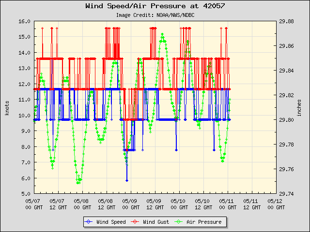
another intersting thing is the near by buoy the winds are not impressive meaning nothing really points to a closed low ..
but the pressure at this buoy is quite low considering there is now closed circulation.
http://www.ndbc.noaa.gov/station_page.php?station=42057
look whats happening right as the western edge of the convection approaches this buoy .. the pressure is falling fast..
0 likes

So the whole compex will be lifted to the NW in other words including the southerly blob which is attracting attention...as it happens IR does hint at this process starting to occur now. If that happens then I can well imagine development tomorrow because there are some interesting little features starting to get going on that southern side.
What an interesting wave!
What an interesting wave!
Last edited by KWT on Sat Jul 19, 2008 7:06 pm, edited 1 time in total.
0 likes
-
zaqxsw75050

- Tropical Storm

- Posts: 178
- Joined: Thu Mar 06, 2008 4:21 pm
- Location: Hong Kong
Re: ATL: INVEST 94L in Western Caribbean
http://www.ssd.noaa.gov/goes/east/carb/loop-wv.html
it is just me or the whole thing is gaining a little latitude in this loop?
it is just me or the whole thing is gaining a little latitude in this loop?
0 likes
-
gatorcane
- S2K Supporter
- Posts: 23703
- Age: 47
- Joined: Sun Mar 13, 2005 3:54 pm
- Location: Boca Raton, FL
Re:
KWT wrote:zaqxsw75050, that is interesting I think thats what wxman57 is talking about with the whole complex flaring ever further north, then once it reaches more favorable conditions a center would form.
Yes the ULL does appear to be getting into position to push this energy NW...process has appeared to have started.
0 likes
-
Aric Dunn
- Category 5
- Posts: 21238
- Age: 43
- Joined: Sun Sep 19, 2004 9:58 pm
- Location: Ready for the Chase.
- Contact:
Re: ATL: INVEST 94L in Western Caribbean
here is the updated graph... pressure at that buoy now 1008 ,, and that is still ahead of that convection. when a center does close off the system sure has a good jump start i would say....
0 likes
-
Aric Dunn
- Category 5
- Posts: 21238
- Age: 43
- Joined: Sun Sep 19, 2004 9:58 pm
- Location: Ready for the Chase.
- Contact:
Re:
HURAKAN wrote:AL, 94, 2008072000, , BEST, 0, 160N, 811W, 35, 1007
Pressure down to 1007 mb.
would not be surprised when the convection hits that buoy it maybe lower than 1007.. right now that buoy is at 1008
0 likes
-
cycloneye

- Admin

- Posts: 148728
- Age: 69
- Joined: Thu Oct 10, 2002 10:54 am
- Location: San Juan, Puerto Rico
Re: ATL: INVEST 94L in Western Caribbean
16.0n that is north of what was discussed earlier here.
0 likes

Re: ATL: INVEST 94L in Western Caribbean
Getting ready make the move to an upgrade? (finally)
0 likes
-
HURAKAN

- Professional-Met

- Posts: 46086
- Age: 38
- Joined: Thu May 20, 2004 4:34 pm
- Location: Key West, FL
- Contact:
Re: ATL: INVEST 94L in Western Caribbean
canegrl04 wrote:Getting ready make the move to an upgrade? (finally)
We still need a LLC.
0 likes
-
gatorcane
- S2K Supporter
- Posts: 23703
- Age: 47
- Joined: Sun Mar 13, 2005 3:54 pm
- Location: Boca Raton, FL
Re:
KWT wrote:Would also allow it to clear Honduras which was a big debate earlier on. Interesting to see the whole complex has jogged to the NW just recently. Can't be far frombeing upgraded IMO but probably still on the cusp.
Yeah seems to be jogging NW now...the whole area of convection is for that matter. Maybe it will clear Honduras and by quite a bit?
I admit I can't figure 94L out.
Last edited by gatorcane on Sat Jul 19, 2008 7:20 pm, edited 1 time in total.
0 likes
-
Matt-hurricanewatcher
Re: ATL: INVEST 94L in Western Caribbean
There is no way that the nhc will upgrade this even if it where to develop a LLC tonight with out recon. This storm could of tricked them many of times, and because of that, they will not take a chance. In I say good for them.
Who knows it could develop once in the western Caribbean. I give this 40% chance of becoming Dolly.
Who knows it could develop once in the western Caribbean. I give this 40% chance of becoming Dolly.
0 likes
Who is online
Users browsing this forum: No registered users and 7 guests