dexterlabio wrote:JMA is about to upgrade 23W into a tropical storm in some hours. It will be named Mirinae.
<Analyses at 27/03 UTC>
Scale -
Intensity -
TD
Center position N14°25'(14.4°)
E144°35'(144.6°)
Direction and speed of movement W 30km/h(15kt)
Central pressure 1002hPa
Maximum wind speed near the center 15m/s(30kt)
Maximum wind gust speed 23m/s(45kt)
<Forecast for 28/03 UTC>
Intensity -
Center position of probability circle N15°50'(15.8°)
E138°25'(138.4°)
Direction and speed of movement W 30km/h(15kt)
Central pressure 998hPa
Maximum wind speed near the center 18m/s(35kt)
Maximum wind gust speed 25m/s(50kt)
Radius of probability circle 220km(120NM)
It seems that the forecast track is beginning to move a little to the north. Still, its projected path is very near to the metropolis.
Here's latest satfix from JTWC:
TPPN10 PGTW 270306
A. TROPICAL STORM 23W (NW OF GUAM)
B. 27/0230Z
C. 14.6N
D. 144.6E
E. SIX/MTSAT
F. N/A
G. IR/EIR/VIS/MSI
H. REMARKS: 40A/PBO SBC/ANMTN.
I. ADDITIONAL POSITIONS:
26/2334Z 14.2N 145.3E AMSU
SMITH
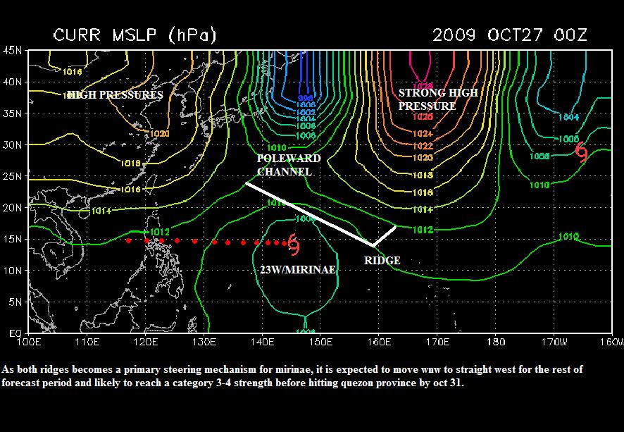
It's supposed to that.....Based on the forecast, The system will move wnw first and then after reaching the peak, it should move wsw......