
yes, all analogs show bad things for the Gulf
Saying that a quiet season means no impacts is very dangerous thinking
Seasonal Indicators (Beyond Day 16): Instability / SST's / MSLP / Steering / Sal
Moderator: S2k Moderators
Forum rules

The posts in this forum are NOT official forecasts and should not be used as such. They are just the opinion of the poster and may or may not be backed by sound meteorological data. They are NOT endorsed by any professional institution or STORM2K. For official information, please refer to products from the National Hurricane Center and National Weather Service.
Re: 2016 indicators: Instability / SST's / MSLP / Steering / Sal
I know the atmosphere has no memory and all that stuff....but....we're just due for an upside surprise in the atlantic basin. Channeling my inner Herb Stein...anything that cannot last forever will eventually end (Florida hurricane drought...I'm looking at you).
0 likes
-
wxman57

- Moderator-Pro Met

- Posts: 23173
- Age: 68
- Joined: Sat Jun 21, 2003 8:06 pm
- Location: Houston, TX (southwest)
Re: 2016 indicators: Instability / SST's / MSLP / Steering / Sal
psyclone wrote:I know the atmosphere has no memory and all that stuff....but....we're just due for an upside surprise in the atlantic basin. Channeling my inner Herb Stein...anything that cannot last forever will eventually end (Florida hurricane drought...I'm looking at you).
A significant upswing in Atlantic activity typically follows a strong El Nino, either in the year immediately following (this year) or the second year after.
0 likes
-
TheStormExpert
Re: 2016 indicators: Instability / SST's / MSLP / Steering / Sal
psyclone wrote:I know the atmosphere has no memory and all that stuff....but....we're just due for an upside surprise in the atlantic basin. Channeling my inner Herb Stein...anything that cannot last forever will eventually end (Florida hurricane drought...I'm looking at you).
Not to mention the last hurricane to affect/hit Florida was a backdoor storm from the Gulf and Western Caribbean.
0 likes
-
TheStormExpert
Re: 2016 indicators: Instability / SST's / MSLP / Steering / Sal
wxman57 wrote:psyclone wrote:I know the atmosphere has no memory and all that stuff....but....we're just due for an upside surprise in the atlantic basin. Channeling my inner Herb Stein...anything that cannot last forever will eventually end (Florida hurricane drought...I'm looking at you).
A significant upswing in Atlantic activity typically follows a strong El Nino, either in the year immediately following (this year) or the second year after.
Yeah I predict at the moment that the 2017 hurricane season could be a nasty one. My opinion though.
0 likes
-
TheStormExpert
Re: 2016 indicators: Instability / SST's / MSLP / Steering / Sal
Alyono wrote:yes, all analogs show bad things for the Gulf
Saying that a quiet season means no impacts is very dangerous thinking
How bad, 2008 type bad?
0 likes
-
srainhoutx

- S2K Supporter

- Posts: 6919
- Age: 68
- Joined: Sun Jan 14, 2007 11:34 am
- Location: Haywood County, NC
- Contact:
Re: 2016 indicators: Instability / SST's / MSLP / Steering / Sal
TheStormExpert wrote:Alyono wrote:yes, all analogs show bad things for the Gulf
Saying that a quiet season means no impacts is very dangerous thinking
How bad, 2008 type bad?
It only takes one to make for a bad season if that ONE hits the Coast where folks live.
0 likes
Carla/Alicia/Jerry(In The Eye)/Michelle/Charley/Ivan/Dennis/Katrina/Rita/Wilma/Ike/Harvey
Member: National Weather Association
Wx Infinity Forums
http://wxinfinity.com/index.php
Facebook.com/WeatherInfinity
Twitter @WeatherInfinity
Member: National Weather Association
Wx Infinity Forums
http://wxinfinity.com/index.php
Facebook.com/WeatherInfinity
Twitter @WeatherInfinity

Re: 2016 indicators: Instability / SST's / MSLP / Steering / Sal
Phil Klotzbach has been very quiet ever since the tropical Atlantic turned warm again in the last few days.

0 likes
-
Andrew92

- S2K Supporter
- Posts: 3247
- Age: 42
- Joined: Mon Jun 16, 2003 12:35 am
- Location: Phoenix, Arizona
Re: 2016 indicators: Instability / SST's / MSLP / Steering / Sal
wxman57 wrote:psyclone wrote:I know the atmosphere has no memory and all that stuff....but....we're just due for an upside surprise in the atlantic basin. Channeling my inner Herb Stein...anything that cannot last forever will eventually end (Florida hurricane drought...I'm looking at you).
A significant upswing in Atlantic activity typically follows a strong El Nino, either in the year immediately following (this year) or the second year after.
Second years after traditional El Nino's are historically very bad news. First years are hit or miss, but usually have one bad hurricane, typically in the Caribbean. Second years after have always had at least one nasty US hurricane, and sometimes another that hits somewhere else....if not also the US.
Still, if the EPAC MDR remains warm this year even with La Nina at the Equator, those rules might make 2017 more similar to a first year after, provided it goes into full-blown La Nina, with 2018 being a nasty year. Too early to tell for sure though, I say let's just prepare for this hurricane season than worry too much about the future.
-Andrew92
0 likes
Re: 2016 indicators: Instability / SST's / MSLP / Steering / Sal
TheStormExpert wrote:psyclone wrote:I know the atmosphere has no memory and all that stuff....but....we're just due for an upside surprise in the atlantic basin. Channeling my inner Herb Stein...anything that cannot last forever will eventually end (Florida hurricane drought...I'm looking at you).
Not to mention the last hurricane to affect/hit Florida was a backdoor storm from the Gulf and Western Caribbean.
Your East Coast bias is showing...HA...our side of the state thinks the opposite. But this underscores an important point...Florida is more vulnerable than many other places simply because it can be hit from multiple directions...making the current run of good luck all the more remarkable.
0 likes
-
TheStormExpert
Re: 2016 indicators: Instability / SST's / MSLP / Steering / Sal
psyclone wrote:TheStormExpert wrote:psyclone wrote:I know the atmosphere has no memory and all that stuff....but....we're just due for an upside surprise in the atlantic basin. Channeling my inner Herb Stein...anything that cannot last forever will eventually end (Florida hurricane drought...I'm looking at you).
Not to mention the last hurricane to affect/hit Florida was a backdoor storm from the Gulf and Western Caribbean.
Your East Coast bias is showing...HA...our side of the state thinks the opposite. But this underscores an important point...Florida is more vulnerable than many other places simply because it can be hit from multiple directions...making the current run of good luck all the more remarkable.
Exactly, Florida is very vulnerable towards hurricanes. It also does not help when a storm moves so fast that it's in and out in 2-4 hours like Wilma allowing it little time to weaken before reaching the other side of the state. Wilma was just as bad here(maybe worse depending where you were) as it was in Naples.
0 likes
-
Hurricaneman

- Category 5

- Posts: 7404
- Age: 45
- Joined: Tue Aug 31, 2004 3:24 pm
- Location: central florida
Re: 2016 indicators: Instability / SST's / MSLP / Steering / Sal
I like to be prepared for a hurricane every season so when it happens{could be this year} your not trying to do stuff last minute and are left out in the cold so to speak because in some worst cases you could be cut off for a few weeks and be stuck
What I'm seeing is some cooling in the EPAC MDR and hopefully that doesn't continue because that would be another favorable thing for the Atlantic addition to the warm Atlantic
The posts in this forum are NOT official forecast and should not be used as such. They are just the opinion of the poster and may or may not be backed by sound meteorological data. They are NOT endorsed by any professional institution or storm2k.org. For official information, please refer to the NHC and NWS products.
0 likes

Re: 2016 indicators: Instability / SST's / MSLP / Steering / Sal
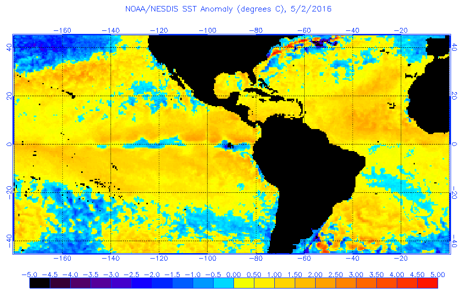
 Wow, is it nearly Hurricane Season again, lol? Feels like I just woke up from a really long slumber. I only went back a couple pages here looking at some of the data and am just mulling over what potential some of these signals might be projecting for the upcoming Atlantic hurricane season. Curiously, the recent warming SST's over the Atlantic don't seem to be focused toward any one specific area such as the MDR, Sub-tropic latitudes, West Atlantic or East Atlantic, but practically basin wide! Of course its too soon to say but i'm wondering "if" the vast extent of the Atlantic basin were to continue looking as if it'll be anomalouslly warm, what corralation might that have with overall sea level pressures? Certainly a localized region could be experiencing high surface pressures or maybe some mid level cap that might supress convection and thus allow greater radiation to heat that particular cloudless region with the result being warmer sea surface temps. So in that case, one could make the case that the warmer SST's are potentially a general result of "high pressure" or essentially stable air (counter productive for tropical development). On the other hand though, could a very large area such as practically the whole N. Atlantic exhibit warmer the normal SST's, might this also possibly indicate greater potential for increased rising air and an indication that the result might be anomalously lower than normal surface pressures??
As a related question, does anyone know what the EURO long range anomalous sea surface projections for the Atlantic basin are and how many months out they are even able to project?
0 likes
Andy D
(For official information, please refer to the NHC and NWS products.)
(For official information, please refer to the NHC and NWS products.)


Re: 2016 indicators: Instability / SST's / MSLP / Steering / Sal
chaser1 wrote::layout: Wow, is it nearly Hurricane Season again, lol? Feels like I just woke up from a really long slumber. I only went back a couple pages here looking at some of the data and am just mulling over what potential some of these signals might be projecting for the upcoming Atlantic hurricane season. Curiously, the recent warming SST's over the Atlantic don't seem to be focused toward any one specific area such as the MDR, Sub-tropic latitudes, West Atlantic or East Atlantic, but practically basin wide! Of course its too soon to say but i'm wondering "if" the vast extent of the Atlantic basin were to continue looking as if it'll be anomalouslly warm, what corralation might that have with overall sea level pressures? Certainly a localized region could be experiencing high surface pressures or maybe some mid level cap that might supress convection and thus allow greater radiation to heat that particular cloudless region with the result being warmer sea surface temps. So in that case, one could make the case that the warmer SST's are potentially a general result of "high pressure" or essentially stable air (counter productive for tropical development). On the other hand though, could a very large area such as practically the whole N. Atlantic exhibit warmer the normal SST's, might this also possibly indicate greater potential for increased rising air and an indication that the result might be anomalously lower than normal surface pressures??
As a related question, does anyone know what the EURO long range anomalous sea surface projections for the Atlantic basin are and how many months out they are even able to project?
Max range is ASO right now:

0 likes
Re: 2016 indicators: Instability / SST's / MSLP / Steering / Sal
Thanks Siker. It looks as if projected Aug-Oct. SST's are only to be slightly above normal, and furthermore limited to latitudes well north of the MDR. I'm guessing that projected surface pressures for that same time period are likely calling for mostly average as well? Either way, it'll be interesting to see if the present Atlantic SST anomalous warming trend were to continue into June/July, and as an effect, whether broad region lower than average surface pressures would result.
0 likes
Andy D
(For official information, please refer to the NHC and NWS products.)
(For official information, please refer to the NHC and NWS products.)
Re: 2016 indicators: Instability / SST's / MSLP / Steering / Sal
chaser1 wrote:Thanks Siker. It looks as if projected Aug-Oct. SST's are only to be slightly above normal, and furthermore limited to latitudes well north of the MDR. I'm guessing that projected surface pressures for that same time period are likely calling for mostly average as well? Either way, it'll be interesting to see if the present Atlantic SST anomalous warming trend were to continue into June/July, and as an effect, whether broad region lower than average surface pressures would result.
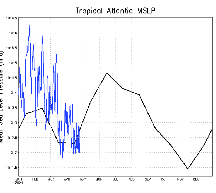
Actually the Euro continues the call for above normal MSLP for this period, as it has for the past few years:

I am curious if someone has 2015's or 2014's charts for pressure (the one available at http://www.ssd.noaa.gov/PS/TROP/TCFP/da ... t_MSLP.gif). Plots of the data suggest no significant above (or below) normal departure.

0 likes
Re: 2016 indicators: Instability / SST's / MSLP / Steering / Sal
Odd? I think I see where you're going with this. My vague recollection regarding recent year EURO extended MSLP forecasts, were that they were also forecasting anomalously high pressures. So basically the EURO just seems to have a "sinking air bias" towards the Atlantic??
0 likes
Andy D
(For official information, please refer to the NHC and NWS products.)
(For official information, please refer to the NHC and NWS products.)
Re: 2016 indicators: Instability / SST's / MSLP / Steering / Sal
If the 2015 EURO did in fact also forecast above average surface pressures, that would be a pretty stark contrast to the reanalyzed NCEP data for the 2014/2015 graph you posted.
0 likes
Andy D
(For official information, please refer to the NHC and NWS products.)
(For official information, please refer to the NHC and NWS products.)
-
Kingarabian

- S2K Supporter
- Posts: 16355
- Joined: Sat Aug 08, 2009 3:06 am
- Location: Honolulu, Hawaii
Re: 2016 indicators: Instability / SST's / MSLP / Steering / Sal
Well to be fair the Euro has not been totally wrong in predicting below average seasons. Even if pressure levels were lower than what the Euro indicated, storms struggled for the most part.
0 likes
RIP Kobe Bryant
Re: 2016 indicators: Instability / SST's / MSLP / Steering / Sal
chaser1 wrote:If the 2015 EURO did in fact also forecast above average surface pressures, that would be a pretty stark contrast to the reanalyzed NCEP data for the 2014/2015 graph you posted.
Luckily the ECMWF site apparently has these runs all the way back through 2011.
Here is the April 2015 forecast for ASO:

Here is the April 2014 forecast for ASO:

Clearly both seasons still ended up below average in activity, but without noticeably above normal MSLP.
0 likes
Who is online
Users browsing this forum: Europa non è lontana, mixedDanilo.E and 193 guests