NATL: HUMBERTO - Remnants - Discussion
Moderator: S2k Moderators
-
CrazyC83
- Professional-Met

- Posts: 34316
- Joined: Tue Mar 07, 2006 11:57 pm
- Location: Deep South, for the first time!
Re: NATL: HUMBERTO - Hurricane - Discussion: Cat 5 on 9/27/25 at 5 PM
This year feels like 1988 and 2007. It's been either feast or famine...either they become monsters or struggle to develop.
3 likes

Re: NATL: HUMBERTO - Hurricane - Discussion: Cat 5 on 9/27/25 at 5 PM
CrazyC83 wrote:This year feels like 1988 and 2007. It's been either feast or famine...either they become monsters or struggle to develop.
Both C5s have been in generally the same areas, also like 07.
2 likes

Re: NATL: HUMBERTO - Hurricane - Discussion: Cat 5 on 9/27/25 at 5 PM
Pelicane wrote:CrazyC83 wrote:This year feels like 1988 and 2007. It's been either feast or famine...either they become monsters or struggle to develop.
Both C5s have been in generally the same areas, also like 07.
That also applies to 2017, with Irma and Maria both peaking near the NE Caribbean.
0 likes
TC naming lists: retirements and intensity
Most aggressive Advisory #1's in North Atlantic (cr. kevin for starting the list)
Most aggressive Advisory #1's in North Atlantic (cr. kevin for starting the list)
Re: NATL: HUMBERTO - Hurricane - Discussion: Cat 5 on 9/27/25 at 5 PM
Teban54 wrote:Pelicane wrote:CrazyC83 wrote:This year feels like 1988 and 2007. It's been either feast or famine...either they become monsters or struggle to develop.
Both C5s have been in generally the same areas, also like 07.
That also applies to 2017, with Irma and Maria both peaking near the NE Caribbean.
And Jose, which was a borderline 5.
1 likes

Re: NATL: HUMBERTO - Hurricane - Discussion: Cat 5 on 9/27/25 at 5 PM
First tone since 1932-33 that we get 2 consecutive years with multiple Cat 5s.
Absolutely insane!!
2025 is the ultimate trickster of a season, a truly Jekyll & Hyde tipe season
Absolutely insane!!
2025 is the ultimate trickster of a season, a truly Jekyll & Hyde tipe season
2 likes
Georges '98, Irene '99, Frances '04, Jeanne '04, Katrina '05, Wilma '05, Gustav '08, Isaac '12, Matthew '16, Florence '18, Michael '18, Ian '22

Re: NATL: HUMBERTO - Hurricane - Discussion: Cat 5 on 9/27/25 at 5 PM
MarioProtVI wrote:The mad lads actually did it. Wow. Humberto avenges Sam.
What's crazy is that if Sam (2021) was a 160mph CAT 5 (which many, including myself, believe it was at some point), and Iota (2020) actually hit 160mph and didn't fall just short, then the 2016-2025 period would have been a record 10 consecutive years featuring at least one CAT 5. Joaquin (2015) was also very close at 155mph. But the record streaks being so close together is already impressive (2016-19 and 2022-25).
5 likes
-
Category5Kaiju

- Category 5

- Posts: 4344
- Joined: Thu Dec 24, 2020 12:45 pm
- Location: Seattle during the summer, Phoenix during the winter
Re: NATL: HUMBERTO - Hurricane - Discussion: Cat 5 on 9/27/25 at 5 PM
The number of 155+ mph storms we've had in the Atlantic since 2015 is just phenomenal (let alone the presence of at least one during each season since then). I seriously wonder if Mother Nature will be able to sweep 2026-2029 with this streak as well.
8 likes
Unless explicitly stated, all information in my posts is based on my own opinions and observations. Tropical storms and hurricanes can be extremely dangerous. Refer to an accredited weather research agency or meteorologist if you need to make serious decisions regarding an approaching storm.
Re: NATL: HUMBERTO - Hurricane - Discussion: Cat 5 on 9/27/25 at 5 PM
It's a year of quality over quantity for a change. incredible black hole buzzsaw.
4 likes
-
Hurricane2022

- Category 5
- Posts: 2080
- Joined: Tue Aug 23, 2022 11:38 pm
- Location: Araçatuba, Brazil
Re: NATL: HUMBERTO - Hurricane - Discussion: Cat 5 on 9/27/25 at 5 PM
Wonderful! 


I'm very glad this is officially a Category 5 BUT I'd personally estimate this is at ~150 kt now.
I'm very glad this is officially a Category 5 BUT I'd personally estimate this is at ~150 kt now.
Last edited by Hurricane2022 on Sat Sep 27, 2025 4:18 pm, edited 1 time in total.
8 likes
Sorry for the bad English sometimes...!
For reliable and detailed information for any meteorological phenomenon, please consult the National Hurricane Center, Joint Typhoon Warning Center , or your local Meteo Center.
--------
ECCE OMNIA NOVA FACIAM (Ap 21,5).
For reliable and detailed information for any meteorological phenomenon, please consult the National Hurricane Center, Joint Typhoon Warning Center , or your local Meteo Center.
--------
ECCE OMNIA NOVA FACIAM (Ap 21,5).

Re: NATL: HUMBERTO - Hurricane - Discussion: Cat 5 on 9/27/25 at 5 PM
So just about every single Humberto has overperformed:
1995:
110 - peak
45 - first advisory forecast (54 hours before peak)
2001:
105 - second peak
note: immediate weakening was forecast for the ten consecutive advisories leading up to this--it was only forecast to increase to 80 prior
100 - peak (first peak)
70 - first advisory forecast (60h before)
2007:
90 - peak
45 - first advisory forecast (18h before)
2013:
Humberto was forecast to 105, peaking at 90--but in a year where there were only two hurricanes, the name still managed to be used on one of them
2019:
125 - peak (beyond the 120h forecast)
105 - forecast peak 120h before
max peak (once it reached 115) was forecast to 120, otherwise was not even forecast to become a major at all until 36h before
2025:
160 - peak
80 - first advisory forecast for the current point
110 - 120h forecast on first advisory
9 likes
The above post is not official and should not be used as such. It is the opinion of the poster and may or may not be backed by sound meteorological data. It is not endorsed by any professional institution or storm2k.org. For official information, please refer to the NHC and NWS products.
-
Hurricane2022
- Category 5
- Posts: 2080
- Joined: Tue Aug 23, 2022 11:38 pm
- Location: Araçatuba, Brazil
Re: NATL: HUMBERTO - Hurricane - Discussion: Cat 5 on 9/27/25 at 5 PM
4 likes
Sorry for the bad English sometimes...!
For reliable and detailed information for any meteorological phenomenon, please consult the National Hurricane Center, Joint Typhoon Warning Center , or your local Meteo Center.
--------
ECCE OMNIA NOVA FACIAM (Ap 21,5).
For reliable and detailed information for any meteorological phenomenon, please consult the National Hurricane Center, Joint Typhoon Warning Center , or your local Meteo Center.
--------
ECCE OMNIA NOVA FACIAM (Ap 21,5).
Re: NATL: HUMBERTO - Hurricane - Discussion: Cat 5 on 9/27/25 at 5 PM
Category5Kaiju wrote:The number of 155+ mph storms we've had in the Atlantic since 2015 is just phenomenal (let alone the presence of at least one during each season since then). I seriously wonder if Mother Nature will be able to sweep 2026-2029 with this streak as well.
I wouldn't bet against it.
1 likes
-
Kingarabian

- S2K Supporter

- Posts: 16376
- Joined: Sat Aug 08, 2009 3:06 am
- Location: Honolulu, Hawaii
Re: NATL: HUMBERTO - Hurricane - Discussion: Cat 5 on 9/27/25 at 5 PM
Beautiful monster
2 likes
RIP Kobe Bryant

Re: NATL: HUMBERTO - Hurricane - Discussion: Cat 5 on 9/27/25 at 5 PM
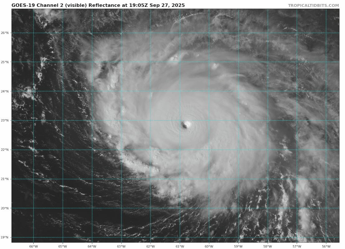
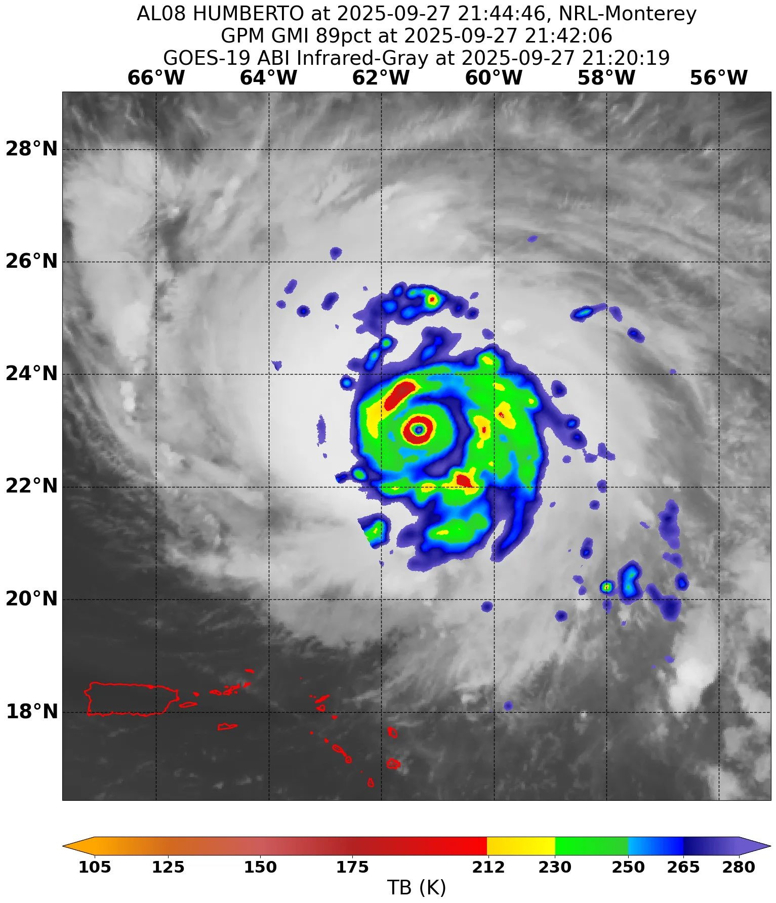
The CDO has expanded significantly in the last hour or two. It’s also a little less smooth around the edges. Both are probably indicative of an incoming EWRC.
Would be cool if recon tomorrow night manages to catch a second round of intensification after the EWRC completes (if it goes through uninterrupted).
Would be cool if recon tomorrow night manages to catch a second round of intensification after the EWRC completes (if it goes through uninterrupted).
0 likes
Irene '11 Sandy '12 Hermine '16 5/15/2018 Derecho Fay '20 Isaias '20 Elsa '21 Henri '21 Ida '21
I am only a meteorology enthusiast who knows a decent amount about tropical cyclones. Look to the professional mets, the NHC, or your local weather office for the best information.
I am only a meteorology enthusiast who knows a decent amount about tropical cyclones. Look to the professional mets, the NHC, or your local weather office for the best information.
-
cycloneye

- Admin

- Posts: 149664
- Age: 69
- Joined: Thu Oct 10, 2002 10:54 am
- Location: San Juan, Puerto Rico
Re: NATL: HUMBERTO - Hurricane - Discussion: Cat 5 on 9/27/25 at 5 PM
1 likes
Visit the Caribbean-Central America Weather Thread where you can find at first post web cams,radars
and observations from Caribbean basin members Click Here
and observations from Caribbean basin members Click Here
Re: NATL: HUMBERTO - Hurricane - Discussion: Cat 5 on 9/27/25 at 5 PM
Some records held by the name Humberto:
- Humberto is now one of the 4 names that have become a hurricane 6 times, the highest on record.
- The other 6-time hurricane users are: Earl, Florence, and Frances.
- Humberto became a hurricane every time the name was used. Among such "perfect record" holders, Humberto had a greater number of uses by a long shot.
- Other "perfect record" holders have only managed a streak of at most 4 uses. All such names with 4 uses are no longer on today's naming lists: Felix, Floyd, Gladys, Lili.
- Among the list of names still in use today, only two other names had perfect records after a measly 2 uses: Rafael and Holly. (Holly, the replacement of Helene, only got here because the name was used twice before the modern naming lists.)
11 likes
TC naming lists: retirements and intensity
Most aggressive Advisory #1's in North Atlantic (cr. kevin for starting the list)
Most aggressive Advisory #1's in North Atlantic (cr. kevin for starting the list)
Re: NATL: HUMBERTO - Hurricane - Discussion: Cat 5 on 9/27/25 at 5 PM
Sunset:
5 likes
TC naming lists: retirements and intensity
Most aggressive Advisory #1's in North Atlantic (cr. kevin for starting the list)
Most aggressive Advisory #1's in North Atlantic (cr. kevin for starting the list)
-
Iceresistance

- Category 5
- Posts: 9605
- Age: 22
- Joined: Sat Oct 10, 2020 9:45 am
- Location: Tecumseh, OK/Norman, OK
Re: NATL: HUMBERTO - Hurricane - Discussion: Cat 5 on 9/27/25 at 5 PM
5 likes
Bill 2015 & Beta 2020
Winter 2020-2021
All observations are in Tecumseh, OK unless otherwise noted.
Winter posts are focused mainly for Oklahoma & Texas.
Take any of my forecasts with a grain of salt, refer to the NWS, SPC, and NHC for official information
Never say Never with weather! Because ANYTHING is possible!
Winter 2020-2021
All observations are in Tecumseh, OK unless otherwise noted.
Winter posts are focused mainly for Oklahoma & Texas.
Take any of my forecasts with a grain of salt, refer to the NWS, SPC, and NHC for official information
Never say Never with weather! Because ANYTHING is possible!
Re: NATL: HUMBERTO - Hurricane - Discussion: Cat 5 on 9/27/25 at 5 PM
From that microwave pass EWRC is not immenent, but will likely happen within the next 12h.
4 likes


Re: NATL: HUMBERTO - Hurricane - Discussion: Cat 5 on 9/27/25 at 5 PM
Still has some time to strengthen before internal mechanics disrupt this round of intensification. Though I'm a little curious as to why intensification to 145 kts is explicitly forecast, when the question of whether it verifies or not it will essentially come down to a judgement call in the absence of recon. It's quite possible that the storm is near or at that strength already, but T7.0 (subjective) and T7.2 (ADT) is probably the best Humberto can manage in the time it has, which equates to roughly...140 kts, still. It took a T7.5 fix for Typhoon Ragasa to get upgraded to 145, and that was with impressive surface observations and a major landfall threat. Hard to imagine that happening here, though I know it's a different agency issuing the advisories.
4 likes
Who is online
Users browsing this forum: No registered users and 52 guests