NATL: IMELDA - Models
Moderator: S2k Moderators
-
Kingarabian

- S2K Supporter

- Posts: 16348
- Joined: Sat Aug 08, 2009 3:06 am
- Location: Honolulu, Hawaii
Re: NATL: NINE - Models
Hope the Euro also continues to show OTS. The inland flooding estimates for SC and NC were no joke.
2 likes
RIP Kobe Bryant
Re: NATL: NINE - Models
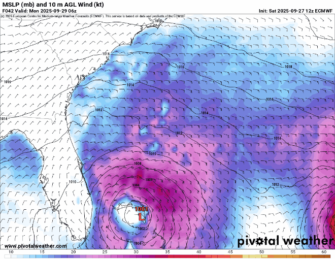
12z Euro hovers and loops around offshore of the carolinas Tuesday-Saturday then heads up to Wilmington/Morehead city. Euro is back to a (Delayed) landfall.
0 likes

Re: NATL: NINE - Models
Looks like some of 12z models are showing a slightly faster movement for TD9 that brings it onshore or close to shore near GA-SC border region in 3 days and then steering collapses resulting a slow meandering over land or offshore (HAFS, HMON & ECM). Others like CMC, GFS and ICON show a much stronger east movement following Humberto before it reaches the coast. Still a very difficult forecast.
1 likes
-
Kingarabian
- S2K Supporter
- Posts: 16348
- Joined: Sat Aug 08, 2009 3:06 am
- Location: Honolulu, Hawaii
Re: NATL: NINE - Models
BobHarlem wrote:12z Euro hovers and loops around offshore of the carolinas Tuesday-Saturday then heads up to Wilmington/Morehead city. Euro is back to a (Delayed) landfall.
https://i.postimg.cc/7hNSvtVx/floop-ecmwf-full-2025092712-sfcwind-mslp-swatl.gif
Potential for some serious flooding with this solution.
1 likes
RIP Kobe Bryant
Re: NATL: NINE - Models
ronjon wrote:Rut Roh...12z HAFS-A (973 mb) and HMON (976mb) into Savannah area at 72-75 hours. 12z HAFS-A much faster than 06z run.
-The NHC 2PM position was 22.0N, 76.5W.
-The HMON 2PM position was ~22N, 77W or 35 miles too far W.
-It’s hard to find a HAFS-A 2PM position.
-The HWRF 2PM position was 21.8N, 76.8W, ~25 miles too far SW fwiw
1 likes
Personal Forecast Disclaimer:
The posts in this forum are NOT official forecasts and should not be used as such. They are just the opinion of the poster and may or may not be backed by sound meteorological data. They are NOT endorsed by any professional institution or storm2k.org. For official information, please refer to the NHC and NWS products.
The posts in this forum are NOT official forecasts and should not be used as such. They are just the opinion of the poster and may or may not be backed by sound meteorological data. They are NOT endorsed by any professional institution or storm2k.org. For official information, please refer to the NHC and NWS products.

Re: NATL: NINE - Models
BobHarlem wrote:12z Euro hovers and loops around offshore of the carolinas Tuesday-Saturday then heads up to Wilmington/Morehead city. Euro is back to a (Delayed) landfall.
https://i.postimg.cc/7hNSvtVx/floop-ecmwf-full-2025092712-sfcwind-mslp-swatl.gif
I'm not buying this one at all.
0 likes


Re: NATL: NINE - Models
^^^
The North Wall has moved south about 100 miles from previous set.
The North Wall has moved south about 100 miles from previous set.
1 likes
I'm not a meteorologist, I'm an electronics engineer. While I can probably fix your toaster oven, you're not going to learn about storms from me!
New Mexico had no hurricanes. Then I moved to NC right before Fran.....
New Mexico had no hurricanes. Then I moved to NC right before Fran.....

-
JtSmarts

- S2K Supporter
- Posts: 1442
- Age: 40
- Joined: Thu Jul 10, 2003 1:29 pm
- Location: Columbia, South Carolina
Re: NATL: NINE - Models
This is turning into an epic battle between the Hurricane models and the Global models. The hurricane models all have that eyewall coming very close to the GA/SC coasts. It's incredibly fascinating from a meteorological perspective, I'm keeping notes on what's been happening so I'll remember when future model battles occur.
4 likes
Re: NATL: NINE - Models
JtSmarts wrote:This is turning into an epic battle between the Hurricane models and the Global models. The hurricane models all have that eyewall coming very close to the GA/SC coasts. It's incredibly fascinating from a meteorological perspective, I'm keeping notes on what's been happening so I'll remember when future model battles occur.
Globals are usually better for track. And models are initializing too far W.
2 likes
Personal Forecast Disclaimer:
The posts in this forum are NOT official forecasts and should not be used as such. They are just the opinion of the poster and may or may not be backed by sound meteorological data. They are NOT endorsed by any professional institution or storm2k.org. For official information, please refer to the NHC and NWS products.
The posts in this forum are NOT official forecasts and should not be used as such. They are just the opinion of the poster and may or may not be backed by sound meteorological data. They are NOT endorsed by any professional institution or storm2k.org. For official information, please refer to the NHC and NWS products.
-
TomballEd
- Category 5

- Posts: 1263
- Age: 62
- Joined: Wed Aug 16, 2023 4:52 pm
- Location: Spring/Klein area, not Tomball
Re: NATL: NINE - Models
LarryWx wrote:JtSmarts wrote:This is turning into an epic battle between the Hurricane models and the Global models. The hurricane models all have that eyewall coming very close to the GA/SC coasts. It's incredibly fascinating from a meteorological perspective, I'm keeping notes on what's been happening so I'll remember when future model battles occur.
Globals are usually better for track. And models are initializing too far W.
The center is still not very well defined looking at satellite and recon. Ensembles are the way to go when there are questions of initialization, I'd say eyeball averaging Euro, Canadian and GFS perturbations, 85% OTS and 15% either landfall or close enough to landfall to have affects beyond rough surf and strong breezes. The later this waits to turn more N, the better the chance Humberto gets past it in latitude and sling it out to sea.
3 likes
Re: NATL: NINE - Models
18z icon is a little right of the 12z (further away from Florida) and only gets to 29.7N before heading east (12z made it to 30.5N).
0 likes
-
ConvergenceZone
.gif)
- Category 5
- Posts: 5241
- Joined: Fri Jul 29, 2005 1:40 am
- Location: Northern California
Re: NATL: NINE - Models
TomballEd wrote:LarryWx wrote:JtSmarts wrote:This is turning into an epic battle between the Hurricane models and the Global models. The hurricane models all have that eyewall coming very close to the GA/SC coasts. It's incredibly fascinating from a meteorological perspective, I'm keeping notes on what's been happening so I'll remember when future model battles occur.
Globals are usually better for track. And models are initializing too far W.
The center is still not very well defined looking at satellite and recon. Ensembles are the way to go when there are questions of initialization, I'd say eyeball averaging Euro, Canadian and GFS perturbations, 85% OTS and 15% either landfall or close enough to landfall to have affects beyond rough surf and strong breezes. The later this waits to turn more N, the better the chance Humberto gets past it in latitude and sling it out to sea.
I agree with this post regarding the models. We have been so lucky this year so far. And Thank God for that! It's almost as if Mother nature is saying, "you guys deserve a break this year".
1 likes
-
Weathertracker96
- Tropical Storm

- Posts: 150
- Joined: Mon Oct 16, 2023 3:41 pm
Re: NATL: NINE - Models
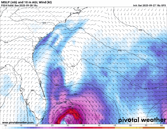
It seems the GFS is slightly more closer to FL but it could be just me.
0 likes
Re: NATL: NINE - Models
The 18z GFS is slower than 12z, and starts to veer right of the 12z (Further away from Florida) around the 27 hour mark. Starts to cut hard east like the icon around 29.6N (Roughly the latitude of St. Augustine) On the way out it manages to stay safely south of Bermuda, although it stalls there similar to 12z, then drifts north and goes right over Bermuda.
Bermuda Landfall:

Bermuda Landfall:
Last edited by BobHarlem on Sat Sep 27, 2025 5:35 pm, edited 7 times in total.
1 likes
-
Kingarabian
- S2K Supporter
- Posts: 16348
- Joined: Sat Aug 08, 2009 3:06 am
- Location: Honolulu, Hawaii
Re: NATL: NINE - Models
GFS looks very similar to the ICON and seems to be headed OTS. Assuming the Euro will follow suit at 18z.
1 likes
RIP Kobe Bryant
-
skillz305
- Category 1

- Posts: 312
- Joined: Sat Sep 08, 2018 11:10 am
- Location: Miami, Florida --> Vero Beach, Florida
Re: NATL: NINE - Models
Weathertracker96 wrote:It seems the GFS is slightly more closer to FL but it could be just me.
It definitely is. We are gonna get some decent bands and squally weather here on EC central FL
4 likes
 Hurricanes: Andrew 1992 - Irene 1999 - Frances 2004 - Jeanne 2004 - Katrina 2005 - Wilma 2005 - Matthew 2016 - Irma 2017 - Ian 2022 - Nicole 2022 - Milton 2024
Re: NATL: NINE - Models
18z euro
Gets just offshore of Charleston late Tuesday (probably close enough for strong ts/hurricane winds)
and sits there and drifts slowly around up off the NC until Friday (end of 18z run)

Gets just offshore of Charleston late Tuesday (probably close enough for strong ts/hurricane winds)
and sits there and drifts slowly around up off the NC until Friday (end of 18z run)
Last edited by BobHarlem on Sat Sep 27, 2025 6:53 pm, edited 1 time in total.
2 likes
-
Kingarabian
- S2K Supporter
- Posts: 16348
- Joined: Sat Aug 08, 2009 3:06 am
- Location: Honolulu, Hawaii
Re: NATL: NINE - Models
18z GFS did turn OTS but also did a weird turn back to the NW closer to the NECONUS. So seems like the models are picking up on the ridge building back again
1 likes
RIP Kobe Bryant
Who is online
Users browsing this forum: No registered users and 105 guests