ATL: MILTON - Post-Tropical - Discussion
Moderator: S2k Moderators

Re: ATL: MILTON - Hurricane - Discussion: 155 mph / 923 mbs
Am thinking 906mb and 165 mph
1 likes
Andy D
(For official information, please refer to the NHC and NWS products.)
(For official information, please refer to the NHC and NWS products.)
-
Iceresistance

- Category 5

- Posts: 9566
- Age: 22
- Joined: Sat Oct 10, 2020 9:45 am
- Location: Tecumseh, OK/Norman, OK
Re: ATL: MILTON - Hurricane - Discussion: 155 mph / 923 mbs
Charleswachal wrote:Iceresistance wrote:I have never seen ADT this high before
https://s11.gifyu.com/images/SBlHm.png
https://s11.gifyu.com/images/SBlHm.png
He got up to a 7.7 earlier when at his previous peak
It wasn't the final ADT that made it that high
0 likes
Bill 2015 & Beta 2020
Winter 2020-2021
All observations are in Tecumseh, OK unless otherwise noted.
Winter posts are focused mainly for Oklahoma & Texas.
Take any of my forecasts with a grain of salt, refer to the NWS, SPC, and NHC for official information
Never say Never with weather! Because ANYTHING is possible!
Winter 2020-2021
All observations are in Tecumseh, OK unless otherwise noted.
Winter posts are focused mainly for Oklahoma & Texas.
Take any of my forecasts with a grain of salt, refer to the NWS, SPC, and NHC for official information
Never say Never with weather! Because ANYTHING is possible!
-
ElectricStorm

- Category 5
- Posts: 5125
- Age: 25
- Joined: Tue Aug 13, 2019 11:23 pm
- Location: Norman, OK
Re: ATL: MILTON - Hurricane - Discussion: 155 mph / 923 mbs
BULLETIN
Hurricane Milton Advisory Number 15
NWS National Hurricane Center Miami FL AL142024
400 PM CDT Tue Oct 08 2024
...MILTON BACK TO CATEGORY 5 STRENGTH...
...FLORIDA RESIDENTS SHOULD GET THEIR FAMILIES AND HOMES READY AND
EVACUATE IF TOLD TO DO SO...
SUMMARY OF 400 PM CDT...2100 UTC...INFORMATION
----------------------------------------------
LOCATION...22.7N 87.5W
ABOUT 320 MI...520 KM WSW OF THE DRY TORTUGAS
ABOUT 480 MI...775 KM SW OF TAMPA FLORIDA
MAXIMUM SUSTAINED WINDS...165 MPH...270 KM/H
PRESENT MOVEMENT...ENE OR 75 DEGREES AT 9 MPH...15 KM/H
MINIMUM CENTRAL PRESSURE...918 MB...27.11 INCHES
8 likes
B.S Meteorology, University of Oklahoma '25
Please refer to the NHC, NWS, or SPC for official information.
Please refer to the NHC, NWS, or SPC for official information.
-
skillz305
- Category 1

- Posts: 312
- Joined: Sat Sep 08, 2018 11:10 am
- Location: Miami, Florida --> Vero Beach, Florida
Re: ATL: MILTON - Hurricane - Discussion: 155 mph / 923 mbs
Cat 5 - 167mph
1 likes
 Hurricanes: Andrew 1992 - Irene 1999 - Frances 2004 - Jeanne 2004 - Katrina 2005 - Wilma 2005 - Matthew 2016 - Irma 2017 - Ian 2022 - Nicole 2022 - Milton 2024
-
ConvergenceZone
.gif)
- Category 5
- Posts: 5241
- Joined: Fri Jul 29, 2005 1:40 am
- Location: Northern California
Re: ATL: MILTON - Hurricane - Discussion: 155 mph / 923 mbs
Frank P wrote:ConvergenceZone wrote:Frank P wrote:910 mb winds 160 mph... bank it..
All the pressure drops people are talking about and it's only going to increase 5 mph? that doesn't seem right.
I only missed it last time by I think about 3 mb... thinking it will take time for the winds to catch up with the pressure... I just wanted to be the outlier just in case since no one else was... going to find out soon though
You will probably be right. I forgot that winds take awhile to catch up to the pressure drops
0 likes
-
Iceresistance
- Category 5
- Posts: 9566
- Age: 22
- Joined: Sat Oct 10, 2020 9:45 am
- Location: Tecumseh, OK/Norman, OK
Re: ATL: MILTON - Hurricane - Discussion: 155 mph / 923 mbs
This part actually scared me 
...FLORIDA RESIDENTS SHOULD GET THEIR FAMILIES AND HOMES READY AND
EVACUATE IF TOLD TO DO SO...
EVACUATE IF TOLD TO DO SO...
3 likes
Bill 2015 & Beta 2020
Winter 2020-2021
All observations are in Tecumseh, OK unless otherwise noted.
Winter posts are focused mainly for Oklahoma & Texas.
Take any of my forecasts with a grain of salt, refer to the NWS, SPC, and NHC for official information
Never say Never with weather! Because ANYTHING is possible!
Winter 2020-2021
All observations are in Tecumseh, OK unless otherwise noted.
Winter posts are focused mainly for Oklahoma & Texas.
Take any of my forecasts with a grain of salt, refer to the NWS, SPC, and NHC for official information
Never say Never with weather! Because ANYTHING is possible!

Re: ATL: MILTON - Hurricane - Discussion: 155 mph / 923 mbs
Iceresistance wrote:I have never seen ADT this high before
https://s11.gifyu.com/images/SBlHm.png
https://s11.gifyu.com/images/SBlHm.png
Highest CI's observed in the Atlantic basin in the last 10 years.
Milton (2024) = 7.7 (1st peak)
Milton (2024) = 7.4 (2nd peak)
Irma (2017) = 7.3
Eta (2024) = 7.3
Michael (2018) = 7.2
Maria (2017) = 7.1
Lorenzo (2019) = 7.1
Iota (2020) = 7.0
Matthew (2016) = 7.0
Beryl (2024) = 6.9
Ian (2022) = 6.9
Lee (2023) = 6.8
10 likes
Re: ATL: MILTON - Hurricane - Discussion: 155 mph / 923 mbs
Agree with them going back to Cat 5 with the much improved satellite appearance and T# around 7.3-7.6.
3 likes
-
Charleswachal
- S2K Supporter

- Posts: 118
- Age: 35
- Joined: Tue Sep 27, 2022 11:24 pm
Re: ATL: MILTON - Hurricane - Discussion: 155 mph / 923 mbs
Iceresistance wrote:Charleswachal wrote:Iceresistance wrote:I have never seen ADT this high before
https://s11.gifyu.com/images/SBlHm.png
https://s11.gifyu.com/images/SBlHm.png
He got up to a 7.7 earlier when at his previous peak
It wasn't the final ADT that made it that high
Code: Select all
2024OCT08 031020 [b] 7.7[/b] 897.8 161.0 [b]7.7 7.8 7.8[/b] NO LIMIT OFF OFF OFF OFF -28.65 -79.73 EYE/P -99 IR 22.4 21.80 89.92 ARCHER GOES16 30.5
it was a 7.7 final number with a 7.8 raw number and a 7.8 adjusted number
1 likes
Tropical Systems Experienced... Hurricane Harvey 2017 (Houston); Tropical Depression Imelda 2019 (Houston); Hurricane Nicolas 2021 (Houston), Hurricane Beryl 2024 (Eye Intercept)
-
Stormgodess

- Category 1
- Posts: 316
- Joined: Mon Sep 14, 2020 1:31 am
Re: ATL: MILTON - Hurricane - Discussion: 155 mph / 923 mbs
SFLcane wrote:LIVE WOBBLE TRACKER: Hurricane Milton’s wobbles off path, could have huge impacts
https://www.wfla.com/weather/tracking-t ... pacts/amp/
Is there a LIVE Wobble Tracker?

0 likes
-
WaveBreaking

- Category 2

- Posts: 713
- Joined: Sun Jun 30, 2024 11:33 am
- Location: US
Re: ATL: MILTON - Hurricane - Discussion: 165 mph / 918 mbs
Going with 890-895 mbar and 150-165kts
1 likes
I am NOT a professional meteorologist, so take all of my posts with a grain of salt. My opinions are mine and mine alone.
-
FLpanhandle91

- Category 5
- Posts: 1039
- Age: 34
- Joined: Mon Sep 13, 2010 3:50 pm
- Location: Fort Walton Beach, FL
Re: ATL: MILTON - Hurricane - Discussion: 155 mph / 923 mbs
Kermit is in the air and halfway there already. We will have double low-level recon for the next few hours. Sit back, grab your favorite beverage, and F5 like crazy!
11 likes

Re: ATL: MILTON - Hurricane - Discussion: 155 mph / 923 mbs
this is pretty crazy to see parroted all over the internet right now.. HAFS-A had this exact track.. when its at the corner of 23 north and 87 it will be exactly where it was supposed to be.
Its like the people I disagree with have converged to wish it away from Tampa or something (understandable but dangerous game to play)
4 likes
Re: ATL: MILTON - Hurricane - Discussion: 165 mph / 918 mbs
Milton wobbled a bit to the southeast today, but the longer-term
12-hour motion is east-northeastward (075/8 kt). Milton is forecast
to turn northeastward and begin accelerating later today as it moves
between a trough digging into the Gulf of Mexico and a ridge near
the Greater Antilles. Because of the wobble, the track guidance
has been initialized a bit to the south of where many of the raw
model fields think the hurricane was centered at 1800 UTC, and this
has caused the entire guidance envelope to shift a bit south on
this cycle. It is still critical to remember that even at 36 hours
(around the time of potential landfall), NHC's track forecasts
can be off by an average of 60 n mi, which means we still can't
pinpoint an exact landfall location, especially if additional
wobbles occur in the short term.
Last edited by caneseddy on Tue Oct 08, 2024 3:58 pm, edited 1 time in total.
3 likes

Re: ATL: MILTON - Hurricane - Discussion: 165 mph / 918 mbs
from the 5 PM discussion..
Milton wobbled a bit to the southeast today, but the longer-term
12-hour motion is east-northeastward (075/8 kt). Milton is forecast
to turn northeastward and begin accelerating later today as it moves
between a trough digging into the Gulf of Mexico and a ridge near
the Greater Antilles. Because of the wobble, the track guidance
has been initialized a bit to the south of where many of the raw
model fields think the hurricane was centered at 1800 UTC, and this
has caused the entire guidance envelope to shift a bit south on
this cycle. It is still critical to remember that even at 36 hours
(around the time of potential landfall), NHC's track forecasts
can be off by an average of 60 n mi, which means we still can't
pinpoint an exact landfall location, especially if additional
wobbles occur in the short term. After landfall, Milton is
forecast to cross Florida and emerge over the Atlantic waters on
Thursday.
0 likes
Just like Jon Snow..."I know nothing" except what I know, and most of what I know is gathered by the fine people of the NHC
-
Frank P
- S2K Supporter
- Posts: 2779
- Joined: Fri Aug 29, 2003 10:52 am
- Location: Biloxi Beach, Ms
- Contact:
Re: ATL: MILTON - Hurricane - Discussion: 165 mph / 918 mbs
Dudes its 918 mb and winds of 165 mph.. per NHC
2 likes
-
Iceresistance
- Category 5
- Posts: 9566
- Age: 22
- Joined: Sat Oct 10, 2020 9:45 am
- Location: Tecumseh, OK/Norman, OK
Re: ATL: MILTON - Hurricane - Discussion: 155 mph / 923 mbs
kevin wrote:Iceresistance wrote:I have never seen ADT this high before
https://s11.gifyu.com/images/SBlHm.png
https://s11.gifyu.com/images/SBlHm.png
Highest CI's observed in the Atlantic basin in the last 10 years.
Milton (2024) = 7.7 (1st peak)
Milton (2024) = 7.4 (2nd peak)
Irma (2017) = 7.3
Eta (2024) = 7.3
Michael (2018) = 7.2
Maria (2017) = 7.1
Lorenzo (2019) = 7.1
Iota (2020) = 7.0
Matthew (2016) = 7.0
Beryl (2024) = 6.9
Ian (2022) = 6.9
Lee (2023) = 6.8
The 7.7 was from where it was CDO related, not EYE related
2 likes
Bill 2015 & Beta 2020
Winter 2020-2021
All observations are in Tecumseh, OK unless otherwise noted.
Winter posts are focused mainly for Oklahoma & Texas.
Take any of my forecasts with a grain of salt, refer to the NWS, SPC, and NHC for official information
Never say Never with weather! Because ANYTHING is possible!
Winter 2020-2021
All observations are in Tecumseh, OK unless otherwise noted.
Winter posts are focused mainly for Oklahoma & Texas.
Take any of my forecasts with a grain of salt, refer to the NWS, SPC, and NHC for official information
Never say Never with weather! Because ANYTHING is possible!
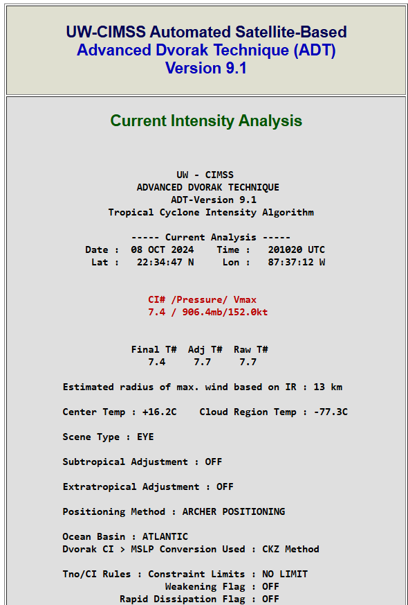
Re: ATL: MILTON - Hurricane - Discussion: 165 mph / 918 mbs
Recon is imminent but:
Current Intensity Analysis
UW - CIMSS
ADVANCED DVORAK TECHNIQUE
ADT-Version 9.1
Tropical Cyclone Intensity Algorithm
----- Current Analysis -----
Date : 08 OCT 2024 Time : 004020 UTC
Lat : 21:50:24 N Lon : 90:21:36 W
CI# /Pressure/ Vmax
7.3 / 909.6mb/149.0kt
Final T# Adj T# Raw T#
7.3 7.6 7.6
Estimated radius of max. wind based on IR :N/A km
Center Temp : -51.3C Cloud Region Temp : -80.2C
Scene Type : EYE
Subtropical Adjustment : OFF
Extratropical Adjustment : OFF
Positioning Method : ARCHER POSITIONING
Ocean Basin : ATLANTIC
Dvorak CI > MSLP Conversion Used : CKZ Method
Tno/CI Rules : Constraint Limits : NO LIMIT
Weakening Flag : OFF
Rapid Dissipation Flag : OFF
2 likes

Re: ATL: MILTON - Hurricane - Discussion: 165 mph / 918 mbs
Looking at the updated windspeed probabilities, Hurricane force probability for Ft. Pierce doubled to 25%.
0 likes
Who is online
Users browsing this forum: No registered users and 26 guests