ATL: Tropical Depression Dolly

Moderator: S2k Moderators

Message
Author
User avatar
WmE
Category 2
Category 2
Posts: 696
Age: 36
Joined: Sat Jun 17, 2006 11:23 am
Location: Vienna, Austria

Re: ATL: INVEST 94L in Western Caribbean

#3581 Postby WmE » Sun Jul 20, 2008 6:23 am

hurricanelandfall wrote:
Matt-hurricanewatcher wrote:There appears to be two LLC's right now. One where derek says around 16.5/81.5 or so with the buoy turning southeastward. While a broader LLC at 17.7/82.3 is with the northern blob in is doing the same with the northern buoy. This is one weird system.
First the problem was it couldn't get one, and now it may have too many :lol: I wonder if it would get two names if it had two llc? That would be funny


Alberto of 2006 had more than one LLC if I remember correctly.
0 likes   

stevetampa33614

Re: ATL: INVEST 94L in Western Caribbean

#3582 Postby stevetampa33614 » Sun Jul 20, 2008 6:26 am

So when will we hear back from the RECON?
0 likes   

Matt-hurricanewatcher

Re: ATL: INVEST 94L in Western Caribbean

#3583 Postby Matt-hurricanewatcher » Sun Jul 20, 2008 6:26 am

The question becomes if I'm right will the nhc upgrade both to their own tropical storms or treat it like Arlene in the western Caribbean with many of smaller LLC inside of a bigger one. That we will have to make a call on with visible. Now if they are not part of a larger cirulation and have their own part of the storm and the LLC like the southern one goe's westward, while the northern one goe's northwestward. If it can do that then each needs to be named.

If they can get away from each other then maybe?
0 likes   

User avatar
HURAKAN
Professional-Met
Professional-Met
Posts: 46086
Age: 38
Joined: Thu May 20, 2004 4:34 pm
Location: Key West, FL
Contact:

Re: ATL: INVEST 94L in Western Caribbean

#3584 Postby HURAKAN » Sun Jul 20, 2008 6:26 am

stevetampa33614 wrote:So when will we hear back from the RECON?


Image
0 likes   

Matt-hurricanewatcher

Re: ATL: INVEST 94L in Western Caribbean

#3585 Postby Matt-hurricanewatcher » Sun Jul 20, 2008 6:28 am

Now what I'm saying is the northern part of the wave could of formed one and the southern part could of formed one. We have seen that happen before.
0 likes   

Derek Ortt

#3586 Postby Derek Ortt » Sun Jul 20, 2008 6:36 am

of course they will not say there are two storms
0 likes   

User avatar
HURAKAN
Professional-Met
Professional-Met
Posts: 46086
Age: 38
Joined: Thu May 20, 2004 4:34 pm
Location: Key West, FL
Contact:

#3587 Postby HURAKAN » Sun Jul 20, 2008 6:39 am

Image

Visible images are arriving.
0 likes   

Cryomaniac
Category 5
Category 5
Posts: 1289
Joined: Tue Aug 15, 2006 2:26 pm
Location: Newark, Nottinghamshire, UK
Contact:

Re:

#3588 Postby Cryomaniac » Sun Jul 20, 2008 6:46 am

Derek Ortt wrote:of course they will not say there are two storms


Do you think they'll find one?
0 likes   

Derek Ortt

#3589 Postby Derek Ortt » Sun Jul 20, 2008 6:50 am

I have no clue at this point

they are finding lower pressures already this morning, though
0 likes   

User avatar
ronjon
Category 5
Category 5
Posts: 4839
Joined: Fri Aug 19, 2005 5:17 pm
Location: Hernando Beach, FL

Re: ATL: INVEST 94L in Western Caribbean

#3590 Postby ronjon » Sun Jul 20, 2008 6:51 am

The whole system is slowing and pin wheeling N-NW as the ULL dives SW over the NE Yucatan. Heaviest convection now around 18.5N-81W where we might have the greatest vorticity now. I expect a decent LLC to emerge (if not there now under the heaviest convection) somewhere between the isle of youth and the NE Yucatan.
Last edited by ronjon on Sun Jul 20, 2008 6:54 am, edited 1 time in total.
0 likes   

User avatar
HURAKAN
Professional-Met
Professional-Met
Posts: 46086
Age: 38
Joined: Thu May 20, 2004 4:34 pm
Location: Key West, FL
Contact:

#3591 Postby HURAKAN » Sun Jul 20, 2008 6:51 am

URNT15 KWBC 201138
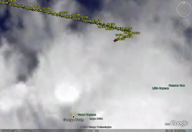
NOAA2 05AAA INVEST HDOB 16 20080720
112830 2005N 08132W 5947 04484 0081 +019 +006 113014 014 036 000 00
112900 2004N 08134W 5946 04492 0077 +021 +006 122013 013 035 001 00
112930 2003N 08136W 5947 04488 0079 +021 +009 129014 015 034 001 00
113000 2001N 08138W 5948 04483 0085 +016 +011 118016 018 036 001 00
113030 2000N 08140W 5948 04482 0087 +015 +013 117020 023 036 000 00
113100 1959N 08142W 5948 04492 0082 +016 +016 109024 026 035 001 00
113130 1958N 08144W 5945 04491 0080 +016 +015 107027 032 034 001 00
113200 1957N 08146W 5948 04493 0085 +015 +015 103034 035 036 001 00
113230 1956N 08148W 5948 04482 0089 +015 +015 105031 033 034 003 00
113300 1954N 08150W 5947 04486 0076 +020 +017 113037 040 033 001 00
113330 1953N 08153W 5948 04481 0080 +017 +014 110041 042 034 001 00
113400 1952N 08155W 5946 04493 0088 +014 +014 114042 043 035 001 00
113430 1951N 08157W 5945 04490 0068 +021 +019 121043 044 035 002 00
113500 1950N 08159W 5946 04485 0089 +010 +010 123037 042 037 002 00
113530 1949N 08202W 5947 04477 0079 +016 +015 129036 038 036 002 00
113600 1949N 08204W 5949 04482 0057 +028 +018 125033 034 035 001 00
113630 1948N 08207W 5946 04500 0073 +021 +020 124032 034 034 002 00
113700 1947N 08209W 5945 04498 0076 +022 +022 123027 029 036 002 00
113730 1946N 08211W 5947 04501 0072 +022 +022 120023 027 033 004 00
113800 1945N 08214W 5949 04487 0070 +023 +023 114023 026 036 002 00

Winds already at TS intensity.
0 likes   

Smurfwicked
Tropical Storm
Tropical Storm
Posts: 164
Age: 41
Joined: Mon Sep 03, 2007 7:47 pm
Location: SETX

Re:

#3592 Postby Smurfwicked » Sun Jul 20, 2008 6:56 am

HURAKAN wrote:Winds already at TS intensity.


Wasn't they TS intensity yesterday, and did they ever drop?
0 likes   

User avatar
HURAKAN
Professional-Met
Professional-Met
Posts: 46086
Age: 38
Joined: Thu May 20, 2004 4:34 pm
Location: Key West, FL
Contact:

Re: Re:

#3593 Postby HURAKAN » Sun Jul 20, 2008 6:59 am

Smurfwicked wrote:
HURAKAN wrote:Winds already at TS intensity.


Wasn't they TS intensity yesterday, and did they ever drop?


No, just pointing out that winds of TS strenght have already been found when the plane was entering the system.

Just in:

114700 1931N 08256W 5945 04475 0054 +030 +029 093026 027 041 009 00

1005.4 mb / 41 knots
0 likes   

User avatar
cycloneye
Admin
Admin
Posts: 146182
Age: 69
Joined: Thu Oct 10, 2002 10:54 am
Location: San Juan, Puerto Rico

Re: ATL: INVEST 94L in Western Caribbean

#3594 Postby cycloneye » Sun Jul 20, 2008 7:00 am

813
ABNT20 KNHC 201159
TWOAT
TROPICAL WEATHER OUTLOOK
NWS TPC/NATIONAL HURRICANE CENTER MIAMI FL
800 AM EDT SUN JUL 20 2008

FOR THE NORTH ATLANTIC...CARIBBEAN SEA AND THE GULF OF MEXICO...

THE STRONG TROPICAL WAVE OVER THE NORTHWESTERN CARIBBEAN SEA
CONTINUES TO PRODUCE NUMEROUS SHOWERS AND THUNDERSTORMS WITH WINDS
TO GALE FORCE IN SQUALLS. ENVIRONMENTAL CONDITIONS ARE EXPECTED TO
BECOME INCREASINGLY FAVORABLE FOR DEVELOPMENT...AND THIS SYSTEM
APPEARS LIKELY TO BECOME A TROPICAL DEPRESSION OR A TROPICAL STORM
WITHIN THE NEXT COUPLE OF DAYS AS IT MOVES WEST-NORTHWESTWARD AT 15
TO 20 MPH TOWARD THE SOUTHERN GULF OF MEXICO. AN AIR FORCE
RECONNAISSANCE AIRCRAFT IS SCHEDULED TO INVESTIGATE THIS SYSTEM
LATER TODAY. REGARDLESS OF DEVELOPMENT... LOCALLY HEAVY RAINS WILL
AFFECT PORTIONS OF WESTERN CUBA AND THE CAYMAN ISLANDS TODAY...AND
THE YUCATAN PENINSULA TONIGHT AND MONDAY. INTERESTS IN THE
NORTHWESTERN CARIBBEAN SEA AND THE YUCATAN PENINSULA SHOULD
CONTINUE TO MONITOR THE PROGRESS OF THIS SYSTEM.
0 likes   

Javlin
Category 5
Category 5
Posts: 1621
Age: 64
Joined: Fri Jul 09, 2004 7:58 pm
Location: ms gulf coast

Re: Re:

#3595 Postby Javlin » Sun Jul 20, 2008 7:02 am

Smurfwicked wrote:
HURAKAN wrote:Winds already at TS intensity.


Wasn't they TS intensity yesterday, and did they ever drop?


I think the point was they are still basically 1.5'-2.0 out from what most think the center is at and TS winds are present.Should look up the code to find out which line is wind speed but work :(
0 likes   

Javlin
Category 5
Category 5
Posts: 1621
Age: 64
Joined: Fri Jul 09, 2004 7:58 pm
Location: ms gulf coast

Re: ATL: INVEST 94L in Western Caribbean

#3596 Postby Javlin » Sun Jul 20, 2008 7:11 am

Before I head out looking at WV it sure looks like if this thing organizes and stack some NW-NNW movement looks like a possibility??thruogh the YUC channel.
0 likes   

User avatar
HURAKAN
Professional-Met
Professional-Met
Posts: 46086
Age: 38
Joined: Thu May 20, 2004 4:34 pm
Location: Key West, FL
Contact:

#3597 Postby HURAKAN » Sun Jul 20, 2008 7:11 am

115230 1921N 08322W 5945 04482 0042 +035 +026 078020 021 030 001 00
115300 1920N 08324W 5946 04475 0041 +033 +027 082023 024 029 000 00

1004 mb.
0 likes   

Matt-hurricanewatcher

Re: ATL: INVEST 94L in Western Caribbean

#3598 Postby Matt-hurricanewatcher » Sun Jul 20, 2008 7:14 am

The pressure center is at 19.2/83.2 at 1004 mbs. Around it the pressure goe's up. This could be a center.
0 likes   

americanrebel

Re: ATL: INVEST 94L in Western Caribbean

#3599 Postby americanrebel » Sun Jul 20, 2008 7:17 am

I have a feeling if that is the lowest pressure they find, they will try to do a couple of loops around that area to see if there is a LLC or not. I hope for our sake they do find a LLC so we can stop worrying about if or when this system will be called Dolly and we will have Dolly.
0 likes   

User avatar
lrak
S2K Supporter
S2K Supporter
Posts: 1770
Age: 58
Joined: Thu Jun 21, 2007 2:48 pm
Location: Corpus Christi, TX

Re: ATL: INVEST 94L in Western Caribbean

#3600 Postby lrak » Sun Jul 20, 2008 7:18 am

looks more south than that location, the bottom blob has a nice look to it.

maybe, 16n 82w :?:
Last edited by lrak on Sun Jul 20, 2008 7:22 am, edited 1 time in total.
0 likes   


Return to “2008”

Who is online

Users browsing this forum: No registered users and 10 guests