
ATL: BERYL - Post-Tropical
Moderator: S2k Moderators
-
NotSparta

- Professional-Met

- Posts: 1677
- Age: 24
- Joined: Fri Aug 18, 2017 8:24 am
- Location: Naples, FL
- Contact:
Re: ATL: BERYL - Tropical Storm
Nice burst
0 likes
This post was probably an opinion of mine, and in no way is official. Please refer to http://www.hurricanes.gov for official tropical analysis and advisories.
My website, with lots of tropical wx graphics, including satellite and recon: http://cyclonicwx.com
My website, with lots of tropical wx graphics, including satellite and recon: http://cyclonicwx.com
-
TheAustinMan

- Category 5

- Posts: 1060
- Joined: Mon Jul 08, 2013 4:26 pm
- Location: Central TX / United States
Re: ATL: BERYL - Tropical Storm
Sizing up Beryl with Marco and Danny, two small Atlantic TCs, with Irma for scale. These I believe are all to scale.
1 MB. Source: I put together some images from the NRL TC images archive.

1 MB. Source: I put together some images from the NRL TC images archive.
8 likes
Treat my opinions with a grain of salt. For official information see your local weather service.
“It's tough to make predictions, especially about the future.”
“It's tough to make predictions, especially about the future.”

Re: ATL: BERYL - Tropical Storm
I can hear it now "..... clear sky conditions and limited to zero chance rain deck or convective build-ups expected over most of Eastern Texas, meanwhile IFR conditions apply as a result of Uncle SAL!"
2 likes
Andy D
(For official information, please refer to the NHC and NWS products.)
(For official information, please refer to the NHC and NWS products.)
-
brohavwx
- Tropical Depression

- Posts: 74
- Age: 64
- Joined: Thu Jun 21, 2018 7:16 pm
- Location: Barbados
- Contact:
Re: ATL: BERYL - Tropical Storm
Here it is winding back up again and several small convection bursts showing up ... and trailing quite a 'tail' of convection behind, some slightly higher in latitude than its main convection. It will be interesting to see what does and if it helps ... its not classified as ITCZ/Monsoon Trough separately in the TW Discussion.
I would say close to 10.5N 44.4W now
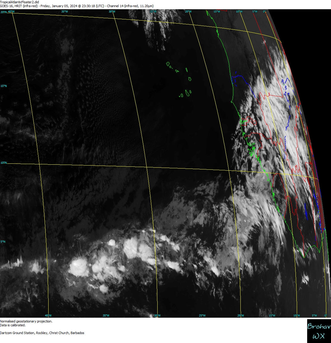
I would say close to 10.5N 44.4W now
0 likes
-
EquusStorm
- Category 5
- Posts: 1649
- Age: 35
- Joined: Thu Nov 07, 2013 1:04 pm
- Location: Jasper, AL
- Contact:
Re: ATL: BERYL - Tropical Storm
I keep thinking back to how much this reminds me of Danny 2015, a significant tiny storm in what would be assumed to be a fairly unfavorable MDR for the season that unexpectedly pulsed up fast east of the islands. Hopefully the impact is very minimal. I eagerly await morning visible images; GOES-16 is awesome.
0 likes
Colors of lost purpose on the canvas of irrelevance
Not a meteorologist, in fact more of an idiot than anything. You should probably check with the NHC or a local NWS office for official information.
Not a meteorologist, in fact more of an idiot than anything. You should probably check with the NHC or a local NWS office for official information.
-
brohavwx
- Tropical Depression
- Posts: 74
- Age: 64
- Joined: Thu Jun 21, 2018 7:16 pm
- Location: Barbados
- Contact:
Re: ATL: BERYL - Tropical Storm
TheAustinMan wrote:Sizing up Beryl with Marco and Danny, two small Atlantic TCs, with Irma for scale. These I believe are all to scale.
1 MB. Source: I put together some images from the NRL TC images archive.
https://i.imgur.com/YrJWlVF.jpg
Want to see my report on Tomas in late 2010 ... look at my satellite images all deep tropics and late October in the following PDF ... up the Friday morning they went from Vigorous Tropical Wave (Thursday) to just Tropical Wave ... put the Recon in the afternoon and by 5 Pm we went straight to moderate Tropical Storm ... we had a hurricane form over us (Barbados) by 6 AM the Saturday - wasn't called so until the 8 AM advisory. I was calling it since the Wednesday or Thursday - look at the size of it and presentation on the Thursday - Beryl looks like nothing compared.
http://www.brohavwx.com/Report-of-the-Development-of-Tropical-Storm-Tomas.pdf
0 likes
-
brohavwx
- Tropical Depression
- Posts: 74
- Age: 64
- Joined: Thu Jun 21, 2018 7:16 pm
- Location: Barbados
- Contact:
Re: ATL: BERYL - Tropical Storm
Here - for comparison - Vigorous Tropical Wave, my ........, yeah right.

2 likes
-
Aric Dunn
- Category 5
- Posts: 21238
- Age: 43
- Joined: Sun Sep 19, 2004 9:58 pm
- Location: Ready for the Chase.
- Contact:
Re: ATL: BERYL - Models
SO far out of the global models. only the GFS initialized it even remotely accurate... which strangely enough with the low resolution appears to have a strong TS or hurricane into the islands..
1 likes
Note: If I make a post that is brief. Please refer back to previous posts for the analysis or reasoning. I do not re-write/qoute what my initial post said each time.
If there is nothing before... then just ask
Space & Atmospheric Physicist, Embry-Riddle Aeronautical University,
I believe the sky is falling...
If there is nothing before... then just ask
Space & Atmospheric Physicist, Embry-Riddle Aeronautical University,
I believe the sky is falling...
-
Twisted-core
Re: ATL: BERYL - Models
A few more of the tropical models think the storm may reach the islands as cat1. Further south higher the odds.

http://mp1.met.psu.edu/~fxg1/GOES_FULL/loop60_atl.html

Yellow cat1


http://mp1.met.psu.edu/~fxg1/GOES_FULL/loop60_atl.html
Yellow cat1
0 likes
-
AtlanticWind

- S2K Supporter

- Posts: 1898
- Age: 67
- Joined: Sun Aug 08, 2004 9:57 pm
- Location: Plantation,Fla
Re: ATL: BERYL - Tropical Storm
If Beryl and 96L both reached hurricane strength in early July that would really
throw off CSU hurricane season forecast.
throw off CSU hurricane season forecast.
0 likes


-
AtlanticWind
- S2K Supporter
- Posts: 1898
- Age: 67
- Joined: Sun Aug 08, 2004 9:57 pm
- Location: Plantation,Fla
Re: ATL: BERYL - Tropical Storm
Siker wrote:Eye is once again trying to make an appearance.
See that, likely near hurricane intensity now I would think.
0 likes
-
AtlanticWind
- S2K Supporter
- Posts: 1898
- Age: 67
- Joined: Sun Aug 08, 2004 9:57 pm
- Location: Plantation,Fla
Re: ATL: BERYL - Tropical Storm
0 likes
-
AutoPenalti
- Category 5
- Posts: 4091
- Age: 29
- Joined: Mon Aug 17, 2015 4:16 pm
- Location: Ft. Lauderdale, Florida
Re: ATL: BERYL - Tropical Storm
It’s not an eye, remember that convection appears to be shallow and thus can leave some false assumptions of an eye forming.
0 likes
The posts in this forum are NOT official forecasts and should not be used as such. They are just the opinion of the poster and may or may not be backed by sound meteorological data. They are NOT endorsed by any professional institution or STORM2K. For official information, please refer to products from the NHC and NWS.
Model Runs Cheat Sheet:
GFS (5:30 AM/PM, 11:30 AM/PM)
HWRF, GFDL, UKMET, NAVGEM (6:30-8:00 AM/PM, 12:30-2:00 AM/PM)
ECMWF (1:45 AM/PM)
TCVN is a weighted averaged
-
TropicalAnalystwx13

- Category 5
- Posts: 2109
- Age: 28
- Joined: Tue Jul 19, 2011 8:20 pm
- Location: Wilmington, NC
- Contact:
Re: ATL: BERYL - Tropical Storm
AutoPenalti wrote:It’s not an eye, remember that convection appears to be shallow and thus can leave some false assumptions of an eye forming.
Er....no, that's an eye. The NHC said so themselves at 11pm.
3 likes
-
AtlanticWind
- S2K Supporter
- Posts: 1898
- Age: 67
- Joined: Sun Aug 08, 2004 9:57 pm
- Location: Plantation,Fla
Re: ATL: BERYL - Tropical Storm
AutoPenalti wrote:It’s not an eye, remember that convection appears to be shallow and thus can leave some false assumptions of an eye forming.
Sorry ,that's clearly an eye. Likely an upgrade to hurricane at 5am update .
1 likes

Re: ATL: BERYL - Tropical Storm
AtlanticWind wrote:AutoPenalti wrote:It’s not an eye, remember that convection appears to be shallow and thus can leave some false assumptions of an eye forming.
Sorry ,that's clearly an eye. Likely an upgrade to hurricane at 5am update .
Surprised there's been no early update like they did with the TS upgrade. Though I don't think they'll go higher than 75mph, I'm thinking Beryl's closest to 85mph at the moment.
Getting more interesting especially since most people a few days ago (myself included) thought this would just be a brief low-end TS.
2 likes
The above post is not official and should not be used as such. It is the opinion of the poster and may or may not be backed by sound meteorological data. It is not endorsed by any professional institution or storm2k.org. For official information, please refer to the NHC and NWS products.
-
Aric Dunn
- Category 5
- Posts: 21238
- Age: 43
- Joined: Sun Sep 19, 2004 9:58 pm
- Location: Ready for the Chase.
- Contact:
Re: ATL: BERYL - Tropical Storm
we have a hurricane.. look at that eye..
just like that..
low shear. ssts getting warmer and warmer.. RI the next 12 hours is quite possible..
just like that..
low shear. ssts getting warmer and warmer.. RI the next 12 hours is quite possible..
1 likes
Note: If I make a post that is brief. Please refer back to previous posts for the analysis or reasoning. I do not re-write/qoute what my initial post said each time.
If there is nothing before... then just ask
Space & Atmospheric Physicist, Embry-Riddle Aeronautical University,
I believe the sky is falling...
If there is nothing before... then just ask
Space & Atmospheric Physicist, Embry-Riddle Aeronautical University,
I believe the sky is falling...
-
HurricaneRyan
- Category 3

- Posts: 846
- Age: 32
- Joined: Sun Dec 05, 2010 3:05 pm
Re: ATL: BERYL - Tropical Storm
Beryl actually becoming a hurricane for once. Wow
2 likes
Kay '22 Hilary '23


Who is online
Users browsing this forum: No registered users and 7 guests