NATL: IMELDA - Post-Tropical - Discussion
Moderator: S2k Moderators

Re: NATL: NINE - Tropical Depression - Discussion
The system continues to tick more and more offshore. QPF estimates have been dialed back along the east coast...we have had a day of encouraging trends.
1 likes

Re: NATL: NINE - Tropical Depression - Discussion
Vortex message from AF303
Center Fix Coordinates: 22.16N 76.27W
5PM EDT NHC
LOCATION...22.2N 76.5W
Center Fix Coordinates: 22.16N 76.27W
5PM EDT NHC
LOCATION...22.2N 76.5W
3 likes
-
emeraldislenc
- Category 2

- Posts: 602
- Joined: Fri Aug 24, 2012 4:49 pm
- Location: Emerald Isle NC
Re: NATL: NINE - Tropical Depression - Discussion
I think until and if a center forms it is difficult to predict the path of the storm!
0 likes
-
floridasun
- Tropical Storm

- Posts: 245
- Joined: Tue Sep 14, 2021 3:59 pm
Re: NATL: NINE - Tropical Depression - Discussion
GCANE wrote:Vortex message from AF303
Center Fix Coordinates: 22.16N 76.27W
5PM EDT NHC
LOCATION...22.2N 76.5W
that more nw movement or west don't have hurr map next to me?
0 likes
Re: NATL: NINE - Tropical Depression - Discussion
If this wasn't so serious I would be laughing.
Latest Euro has it back tracking and making landfall in North Carolina.
One thing the models complete ignore and can't model is eyewall replacement cycles.
One is due for Humberto in the next 24hrs due to its rapid intensification and near Cat 5 strength.
Latest Euro has it back tracking and making landfall in North Carolina.
One thing the models complete ignore and can't model is eyewall replacement cycles.
One is due for Humberto in the next 24hrs due to its rapid intensification and near Cat 5 strength.
2 likes
Re: NATL: NINE - Tropical Depression - Discussion
floridasun wrote:GCANE wrote:Vortex message from AF303
Center Fix Coordinates: 22.16N 76.27W
5PM EDT NHC
LOCATION...22.2N 76.5W
that more nw movement or west don't have hurr map next to me?
Its 13 nm SE of forecast track if you can really call that a surface low.
Looks like AF303 bugged out. Nothing to see here.
1 likes
-
floridasun
- Tropical Storm
- Posts: 245
- Joined: Tue Sep 14, 2021 3:59 pm
Re: NATL: NINE - Tropical Depression - Discussion
that mean relocation more east of last postion and mean stay bit more east of Florida and usa coastlineGCANE wrote:floridasun wrote:GCANE wrote:Vortex message from AF303
Center Fix Coordinates: 22.16N 76.27W
5PM EDT NHC
LOCATION...22.2N 76.5W
that more nw movement or west don't have hurr map next to me?
Its 13 nm SE of forecast track if you can really call that a surface low.
0 likes
-
Miami Storm Tracker

- Category 4

- Posts: 916
- Age: 68
- Joined: Sun Jun 13, 2010 10:12 pm
- Location: Key Largo, Fla.
- Contact:
Re: NATL: NINE - Tropical Depression - Discussion
Afternoon everyone,
Been watching but not overly concerned. At this time it is still disorganized, but also curious , with the warnings from Broward county north for the coastal areas, why nothing in the northeren Florida Keys?
Been watching but not overly concerned. At this time it is still disorganized, but also curious , with the warnings from Broward county north for the coastal areas, why nothing in the northeren Florida Keys?
0 likes
-
floridasun
- Tropical Storm
- Posts: 245
- Joined: Tue Sep 14, 2021 3:59 pm
Re: NATL: NINE - Tropical Depression - Discussion
because were make turn bit close central fl for nowMiami Storm Tracker wrote:Afternoon everyone,
Been watching but not overly concerned. At this time it is still disorganized, but also curious , with the warnings from Broward county north for the coastal areas, why nothing in the northeren Florida Keys?
0 likes
-
floridasun
- Tropical Storm
- Posts: 245
- Joined: Tue Sep 14, 2021 3:59 pm
-
Miami Storm Tracker
- Category 4
- Posts: 916
- Age: 68
- Joined: Sun Jun 13, 2010 10:12 pm
- Location: Key Largo, Fla.
- Contact:
Re: NATL: NINE - Tropical Depression - Discussion
Thank you for the responses, I am actually in north Key Largo.
0 likes
Re: NATL: NINE - Tropical Depression - Discussion
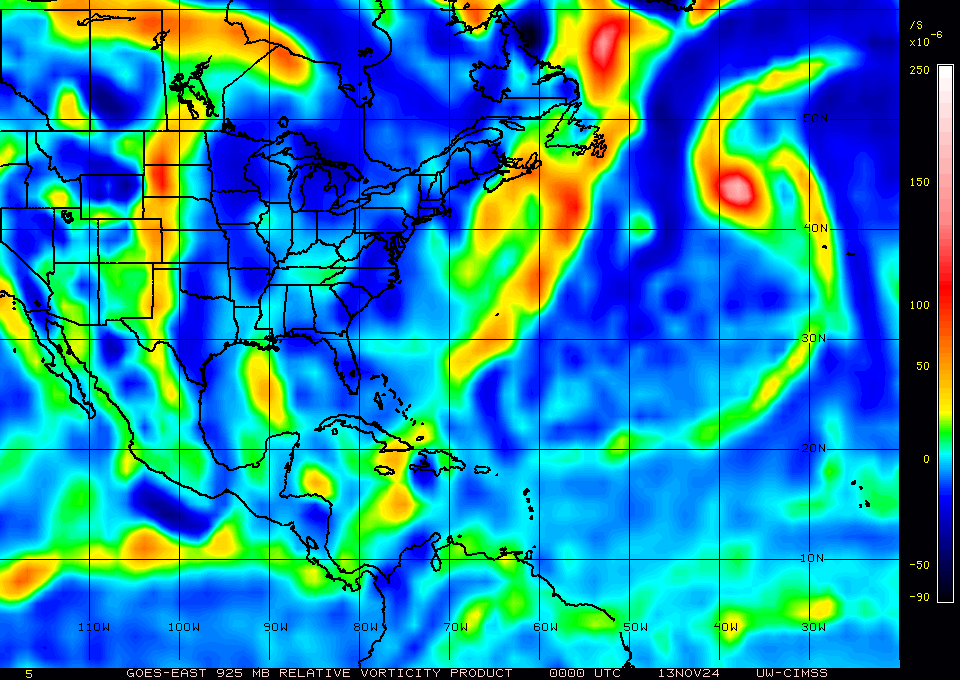
Big time pop up in LL Vort just north of the Yucatan.
Then there is Humberto.
Guess which one TD9 will do the Fujiwhara dance with.
https://tropic.ssec.wisc.edu/real-time/ ... g8vor5.GIF
Then there is Humberto.
Guess which one TD9 will do the Fujiwhara dance with.
https://tropic.ssec.wisc.edu/real-time/ ... g8vor5.GIF
2 likes
Re: NATL: NINE - Tropical Depression - Discussion
Latest track guidance.
About as uncertain as it can get,
Wait until the split moves farther south and Humberto does an EWRC.
https://rammb-data.cira.colostate.edu/t ... 271800.png
About as uncertain as it can get,
Wait until the split moves farther south and Humberto does an EWRC.
https://rammb-data.cira.colostate.edu/t ... 271800.png
1 likes
Re: NATL: NINE - Tropical Depression - Discussion
More high-altitude recon.
Miss Piggy and Kermit will need an overhaul after this one.
Miss Piggy and Kermit will need an overhaul after this one.
1 likes
-
Coolcruiseman
- Tropical Depression

- Posts: 97
- Age: 52
- Joined: Wed Sep 21, 2022 8:10 pm
- Location: Melbourne, FL
Re: NATL: NINE - Tropical Depression - Discussion
GCANE wrote:skillz305 wrote:GCANE wrote:
Maybe 50/50
Watching that front closely in the GOM, and somewhat Humberto as well.
This will be a last minute thing if it makes landfall.
Are you in Florida?
Yes, us on east coast Florida, south and Central are glued to this system. We know how the uncertainty goes. We also like to ask questions to individuals, which do great work on here, their expert opinions on stuff we can’t grasp. We are all on different levels of knowledge. Thanks for all your info you put out. You actually gave us the heads up on tornadic activity from Hurricane Milton last year (I’m not too far from the devastating tornados that landed in central Florida)
Stay safe my friend.
I'll keep the posts going.
My wife is in Europe and I got plenty of cigars.
Pizza is a few minutes away.
Being in the Melbourne area, appreciate the knowledgeable insights you and others provide
2 likes
Re: NATL: NINE - Tropical Depression - Discussion
Anticyclone just formed in the Windward Passage
https://tropic.ssec.wisc.edu/real-time/ ... wg8shr.GIF
https://tropic.ssec.wisc.edu/real-time/ ... wg8shr.GIF
1 likes
Re: NATL: NINE - Tropical Depression - Discussion
I know this is hard to make out.
Cuba and TD9 is just about in the middle.
If you look hard enough you will see it.
This is TPW, what feeds a tropical cyclone.
There is a river from the East Pacific flowing thru Panama straight into TD9.
Its the red.
https://rammb-data.cira.colostate.edu/t ... 272100.png
Cuba and TD9 is just about in the middle.
If you look hard enough you will see it.
This is TPW, what feeds a tropical cyclone.
There is a river from the East Pacific flowing thru Panama straight into TD9.
Its the red.
https://rammb-data.cira.colostate.edu/t ... 272100.png
2 likes
-
cycloneye

- Admin

- Posts: 149720
- Age: 69
- Joined: Thu Oct 10, 2002 10:54 am
- Location: San Juan, Puerto Rico
Re: NATL: NINE - Tropical Depression - Discussion
Getting stronger winds from NOAA plane.
Peak Flight-Level Winds: 38kt at 23:01z
Minimum Extrap. Pressure: 1004.3mb at 22:21z
2 likes
Visit the Caribbean-Central America Weather Thread where you can find at first post web cams,radars
and observations from Caribbean basin members Click Here
and observations from Caribbean basin members Click Here
Re: NATL: NINE - Tropical Depression - Discussion
I think I said this before and sorry if I am a little out of line.
This close in high-altitude recon has minimal benefit at this point.
They need to send planes into the GoM.
This close in high-altitude recon has minimal benefit at this point.
They need to send planes into the GoM.
2 likes
Re: NATL: NINE - Tropical Depression - Discussion
Latest Vortex Message from NOAA2, 3 min ago has 1006mb
22.37N 76.39W
https://www.tropicaltidbits.com/recon/r ... YCLONE.png
Eye drop looks saturated.
It maybe starting uo.
https://www.tropicaltidbits.com/recon/r ... 7-2222.png
22.37N 76.39W
https://www.tropicaltidbits.com/recon/r ... YCLONE.png
Eye drop looks saturated.
It maybe starting uo.
https://www.tropicaltidbits.com/recon/r ... 7-2222.png
Last edited by GCANE on Sat Sep 27, 2025 6:37 pm, edited 2 times in total.
0 likes
Who is online
Users browsing this forum: No registered users and 45 guests