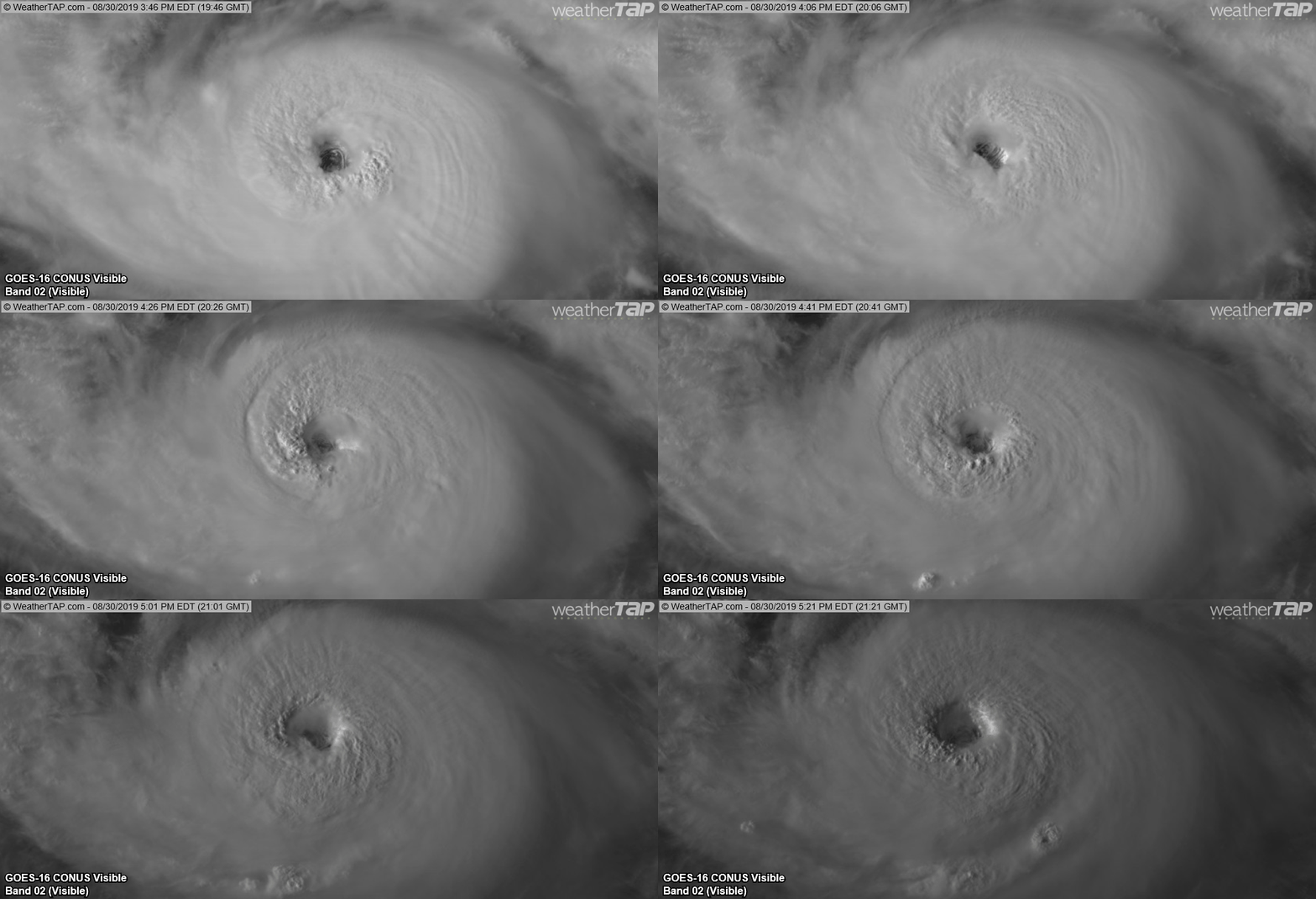
ATL: DORIAN - Post-Tropical - Discussion

Moderator: S2k Moderators

Message
Author
User avatar
Blown Away
S2K Supporter
S2K Supporter
Posts: 10155
Joined: Wed May 26, 2004 6:17 am

Re: ATL: DORIAN - Hurricane - Discussion

#3621 Postby Blown Away » Fri Aug 30, 2019 4:14 pm

jaxfladude wrote:Tv local Jacksonville Florida showing cat two too close to me early next week. Need reassurance that the odds are moving towards Dorian off shore OTS. But that may mean those to the north of me may get hit.


Yeah, rare event with current track into Jacksonville. I think 24 hours will determine the track either into Florida South/Central coast or begin a recurve towards Carolinas or OTS...
0 likes   
Hurricane Eye Experience: David 79, Irene 99, Frances 04, Jeanne 04, Wilma 05… Hurricane Brush Experience: Andrew 92, Erin 95, Floyd 99, Matthew 16, Irma 17, Ian 22, Nicole 22…

Zanthe
Tropical Storm
Tropical Storm
Posts: 149
Age: 31
Joined: Sat May 26, 2012 9:26 pm
Location: New Castle, PA

Re: ATL: DORIAN - Hurricane - Discussion

#3622 Postby Zanthe » Fri Aug 30, 2019 4:17 pm

I think it’s important to note that we’re still a few days away. Of course there’s a chance that Dorian will miss Florida, and we can hope that it does — but there is currently a better chance that Dorian makes a direct landfall along the eastern coast of Florida.

From the 5pm disco.
However, the steering currents will then
weaken, and this should result in a decrease in the hurricane's
forward speed. Given the collapse of the steering currents, the
track forecast by the end of the forecast period is highly
uncertain, and any small deviation in the track could bring the
core of the powerful hurricane well inland over the Florida, keep
it near the coast, or offshore..
1 likes   
I'm no expert, everything I say should be taken with a large amount of salt. I could easily be very, very wrong.
~Zanthe Go Coyotes~

canes92
Tropical Storm
Tropical Storm
Posts: 127
Age: 32
Joined: Tue Mar 06, 2018 1:51 pm

Re: ATL: DORIAN - Hurricane - Discussion

#3623 Postby canes92 » Fri Aug 30, 2019 4:20 pm

Can't stand these model changes. Is he going to make landfall at all???? They're driving me crazy. It's too confusing. Seriously Dorian, make up your freaking mind!
3 likes   

Mouton
S2K Supporter
S2K Supporter
Posts: 221
Age: 79
Joined: Sat Jul 30, 2011 8:13 am
Location: Amelia Island Florida

Re: ATL: DORIAN - Hurricane - Discussion

#3624 Postby Mouton » Fri Aug 30, 2019 4:21 pm

Blown Away wrote:
jaxfladude wrote:Tv local Jacksonville Florida showing cat two too close to me early next week. Need reassurance that the odds are moving towards Dorian off shore OTS. But that may mean those to the north of me may get hit.


Yeah, rare event with current track into Jacksonville. I think 24 hours will determine the track either into Florida South/Central coast or begin a recurve towards Carolinas or OTS...


Similar to Mathew were this to happen. BTW, that would be a slightly inland run after an initial impact in Central Fl as a category 4.

I would be mindful of this from NHC as this is not etched in stone either albeit the last two runs have been encouraging for a more eastern shift. Alas, way to early to make such a call given it will turn more to the west from where it is now according to the NHC. This is some info from the NHC who get paid to make the calls:

"The ridge over the western Atlantic appears to be already building
to the north of Dorian and is beginning to force the hurricane on a
more west-northwest track or 300 degrees at 9 kt. The ridge is
forecast to build even more and steer Dorian on a westward track for
the next 3 to 4 days. However, the steering currents will then
weaken, and this should result in a decrease in the hurricane's
forward speed. Given the collapse of the steering currents, the
track forecast by the end of the forecast period is highly
uncertain, and any small deviation in the track could bring the
core of the powerful hurricane well inland over the Florida, keep
it near the coast, or offshore. The models have not been very
consistent from run to run in terms of the timing of the northward
turn,
but there are more models now indicating that the turn could
occur near the east coast of Florida instead of well inland. Given
this latest change, the NHC forecast has been shifted just a little
to the right at this time, but users should be prepared for
additional adjustements to the left or right depending on future
model trends."

The first team is in there now BTW
4 likes   

hipshot
Category 2
Category 2
Posts: 591
Joined: Tue Jul 06, 2010 9:18 pm
Location: Dallas, Texas

Re: ATL: DORIAN - Hurricane - Discussion

#3625 Postby hipshot » Fri Aug 30, 2019 4:24 pm

[quote="SFLcane"]So the turn has begun this will be key to watch during the next couple of days.[/quote

Turn which directions, north or west?
0 likes   

MacTavish

Re: ATL: DORIAN - Hurricane - Discussion

#3626 Postby MacTavish » Fri Aug 30, 2019 4:25 pm

Assuming he makes one, im looking forward to Levi`s video tonight.
0 likes   

User avatar
fci
S2K Supporter
S2K Supporter
Posts: 3324
Joined: Tue Sep 14, 2004 10:29 am
Location: Lake Worth, FL

Re: ATL: DORIAN - Hurricane - Discussion

#3627 Postby fci » Fri Aug 30, 2019 4:28 pm

CronkPSU wrote:hmmm the NHC did shift the landfall to basically go right up the coast of Florida

https://pbs.twimg.com/media/EDPv7oiWkAEskuR.jpg:large


A subtle move to the right which, if modeling continues as it has most recently; will be followed at 11:00 by a track even more to the right. The discussion portends that possibility.
0 likes   
Personal Forecast Disclaimer:
My posts are just my opinion and are most likely not backed by sound meteorological data. They are NOT endorsed by any professional institution or storm2k.org. For official information, please refer to the NHC and NWS products.
Bottom line is that I am just expressing my opinion!!!

xironman
S2K Supporter
S2K Supporter
Posts: 2522
Joined: Sun Jun 10, 2007 4:53 pm
Location: NoVA

Re: ATL: DORIAN - Hurricane - Discussion

#3628 Postby xironman » Fri Aug 30, 2019 4:28 pm

Decent stadium effect, let's see if we get a better one tomorrow.

Image
6 likes   

User avatar
Siker
Category 4
Category 4
Posts: 904
Age: 28
Joined: Thu Oct 25, 2012 7:36 pm
Location: Miami, FL

Re: ATL: DORIAN - Hurricane - Discussion

#3629 Postby Siker » Fri Aug 30, 2019 4:29 pm

The eye just cleared out completely.
3 likes   

User avatar
fci
S2K Supporter
S2K Supporter
Posts: 3324
Joined: Tue Sep 14, 2004 10:29 am
Location: Lake Worth, FL

Re: ATL: DORIAN - Hurricane - Discussion

#3630 Postby fci » Fri Aug 30, 2019 4:30 pm

ozonepete wrote:
fci wrote:
ozonepete wrote:
It's almost certainly going to hit land. Just not clear where but somewhere from central FL to Hatteras.


I'm not sure you can really say that. While it very well might hit land, the models are trending towards a solution that it could stay offshore.


The models are trending toward a solution that it could stay offshore of Florida, not offshore of the entire southeast coast.
I said "almost certainly" not certainly. The great majority of tracks includng ensemble members show it hitting land somewhere before going out to sea. this is because, if you look at the steering currents from now until 10 days out, the least plausible path is out to sea without ever hitting land. That's just what the models said. So the models support almost certainly. Ok? :)


You are the Pro sir, so I defer to you. Appreciate the discussion!
1 likes   
Personal Forecast Disclaimer:
My posts are just my opinion and are most likely not backed by sound meteorological data. They are NOT endorsed by any professional institution or storm2k.org. For official information, please refer to the NHC and NWS products.
Bottom line is that I am just expressing my opinion!!!

norva13x
Tropical Storm
Tropical Storm
Posts: 102
Joined: Fri Sep 01, 2017 10:41 am

Re: ATL: DORIAN - Hurricane - Discussion

#3631 Postby norva13x » Fri Aug 30, 2019 4:31 pm

fci wrote:
CronkPSU wrote:hmmm the NHC did shift the landfall to basically go right up the coast of Florida

https://pbs.twimg.com/media/EDPv7oiWkAEskuR.jpg:large


A subtle move to the right which, if modeling continues as it has most recently; will be followed at 11:00 by a track even more to the right. The discussion portends that possibility.


They also mention it could shift the other way, still a lot of uncertainty.
1 likes   

psyclone
S2K Supporter
S2K Supporter
Posts: 4769
Joined: Wed Aug 24, 2005 9:04 pm
Location: palm harbor fl

Re: ATL: DORIAN - Hurricane - Discussion

#3632 Postby psyclone » Fri Aug 30, 2019 4:31 pm

So the trends here are encouraging for the florida peninsula from west to east assuming we keep baby stepping the right direction. As most of us know, one need not get too far west of a north or north northwestward moving hurricane to get out of the nasty weather. I am feeling very optimistic here in the bay area and am hopeful for more east shifts so folks off to the east can sense some good news. Naturally a positive trend can reverse but this is the best we can hope for at this point. we have a powerful storm with sufficient time to go somewhere else if pre existing trends remain intact. I like it.
1 likes   

User avatar
Blinhart
Category 5
Category 5
Posts: 2081
Age: 48
Joined: Thu Sep 08, 2011 3:13 pm
Location: Crowley, La.

Re: ATL: DORIAN - Hurricane - Discussion

#3633 Postby Blinhart » Fri Aug 30, 2019 4:31 pm

CryHavoc wrote:
fci wrote:
AxaltaRacing24 wrote:That doesn’t mean that they won’t trend back. Dorian really has no real escape route. If it doesn’t make landfall, it’d be very very close.


For sure, they could.
But, the trend here is towards a "climatological solution" so the possibility truly exists that it will not make landfall.
Not true that there is no real escape route as it relates to hitting the CONUS.
Northern Bahamas are another story.


Climatological "solutions" have no place in a discussion about the path of one hurricane. There's no data to support your hypothesis.


They have all the rights to be in the discussion.
4 likes   
Personal Forecast Disclaimer:
The posts in this forum are NOT official forecast and should not be used as such. They are just the opinion of the poster and may or may not be backed by sound meteorological data. They are NOT endorsed by any professional institution or storm2k.org. For official information, please refer to the NHC and NWS products.

craptacular
Category 2
Category 2
Posts: 581
Joined: Wed Aug 02, 2006 9:17 pm
Location: The Mad City, WI

Re: ATL: DORIAN - Hurricane - Discussion

#3634 Postby craptacular » Fri Aug 30, 2019 4:33 pm

craptacular wrote:
Aric Dunn wrote:we need more g4 flights.. not sure why there is not one today..


Am curious as well, as they were scheduled for every 12 hours. Anyway, I checked FlightAware, and Gonzo (NOAA 49, G-IV, tail number N49RF) made a one-hour flight from Lakeland to Savannah, GA very early this morning ... nothing since then. The TCPOD issued yesterday mentioned the G-IV flights for tomorrow would be taking off from Lakeland (KLAL). However, the TCPOD issued today still showed scheduled flights for tomorrow, and then mentioned Sunday's flights would take off from New Orleans. I wonder if Savannah has some specialized maintenance capability that they can't do at Lakeland. I'd think there has to be some big problem for them not to be flying a mission on this critical day.


Yes, quoting myself, but I didn't realize until finding it now that Gulfstream is based in Savannah and has significant assembly and service facilities there. So, seems likely to me that Gonzo is in for some emergency work.
1 likes   

User avatar
CronkPSU
S2K Supporter
S2K Supporter
Posts: 2014
Joined: Sun Aug 07, 2005 10:44 pm
Location: Avalon Park, FL

Re: ATL: DORIAN - Hurricane - Discussion

#3635 Postby CronkPSU » Fri Aug 30, 2019 4:33 pm

fci wrote:
CronkPSU wrote:hmmm the NHC did shift the landfall to basically go right up the coast of Florida

https://pbs.twimg.com/media/EDPv7oiWkAEskuR.jpg:large


A subtle move to the right which, if modeling continues as it has most recently; will be followed at 11:00 by a track even more to the right. The discussion portends that possibility.


well the discussion gave just as much credence to having to move it back left as well
3 likes   
Just like Jon Snow..."I know nothing" except what I know, and most of what I know is gathered by the fine people of the NHC

User avatar
fci
S2K Supporter
S2K Supporter
Posts: 3324
Joined: Tue Sep 14, 2004 10:29 am
Location: Lake Worth, FL

Re: ATL: DORIAN - Hurricane - Discussion

#3636 Postby fci » Fri Aug 30, 2019 4:35 pm

CryHavoc wrote:
fci wrote:
AxaltaRacing24 wrote:That doesn’t mean that they won’t trend back. Dorian really has no real escape route. If it doesn’t make landfall, it’d be very very close.


For sure, they could.
But, the trend here is towards a "climatological solution" so the possibility truly exists that it will not make landfall.
Not true that there is no real escape route as it relates to hitting the CONUS.
Northern Bahamas are another story.


Climatological "solutions" have no place in a discussion about the path of one hurricane. There's no data to support your hypothesis.


Wow. Climatology is based purely on historical data.
So to say there is "no data" is false.
Now if you are claiming there is no data from Dorian today, I'll give you that.
If we stacked up all the scenarios, climatology would win out as the most common solution because it is based on what has actually happened many times.
1 likes   
Personal Forecast Disclaimer:
My posts are just my opinion and are most likely not backed by sound meteorological data. They are NOT endorsed by any professional institution or storm2k.org. For official information, please refer to the NHC and NWS products.
Bottom line is that I am just expressing my opinion!!!

HurricaneFrances04
Category 2
Category 2
Posts: 597
Joined: Mon Jun 25, 2012 8:09 am
Location: Fort Lauderdale, Florida

Re: ATL: DORIAN - Hurricane - Discussion

#3637 Postby HurricaneFrances04 » Fri Aug 30, 2019 4:39 pm

Wow, too bad the sun is setting because that eye is incredible.
1 likes   

User avatar
Hybridstorm_November2001
S2K Supporter
S2K Supporter
Posts: 2811
Joined: Sat Aug 21, 2004 2:50 pm
Location: SW New Brunswick, Canada
Contact:

Re: ATL: DORIAN - Hurricane - Discussion

#3638 Postby Hybridstorm_November2001 » Fri Aug 30, 2019 4:39 pm

Interesting how Dorian looked like Andrew last night and this afternoon he looks like Hugo on the sat images. :eek:
2 likes   

supercane4867
Category 5
Category 5
Posts: 4966
Joined: Wed Nov 14, 2012 10:43 am

Re: ATL: DORIAN - Hurricane - Discussion

#3639 Postby supercane4867 » Fri Aug 30, 2019 4:39 pm

Likely 110kts or higher

Image
5 likes   

User avatar
Ntxw
Storm2k Moderator
Storm2k Moderator
Posts: 22790
Joined: Wed Oct 21, 2009 6:34 pm
Location: DFW, Texas

Re: ATL: DORIAN - Hurricane - Discussion

#3640 Postby Ntxw » Fri Aug 30, 2019 4:39 pm

Eye is warm and symmetrical now. Should be classified as Cat 4 sometime this evening I would think. This looks to me at least 110-115kts.

Image
14 likes   
The above post and any post by Ntxw is NOT an official forecast and should not be used as such. It is just the opinion of the poster and may or may not be backed by sound meteorological data. It is NOT endorsed by any professional institution including Storm2k. For official information, please refer to NWS products.

  Help support Storm2K!
Help Support Storm2K


Return to “2019”

Who is online

Users browsing this forum: No registered users and 1 guest