ATL: DORIAN - Models
Moderator: S2k Moderators
-
AutoPenalti
- Category 5

- Posts: 4091
- Age: 29
- Joined: Mon Aug 17, 2015 4:16 pm
- Location: Ft. Lauderdale, Florida
Re: ATL: DORIAN - Models
The 250mb ridge is squashed. This should force it WSW.
0 likes
The posts in this forum are NOT official forecasts and should not be used as such. They are just the opinion of the poster and may or may not be backed by sound meteorological data. They are NOT endorsed by any professional institution or STORM2K. For official information, please refer to products from the NHC and NWS.
Model Runs Cheat Sheet:
GFS (5:30 AM/PM, 11:30 AM/PM)
HWRF, GFDL, UKMET, NAVGEM (6:30-8:00 AM/PM, 12:30-2:00 AM/PM)
ECMWF (1:45 AM/PM)
TCVN is a weighted averaged
-
AtlanticWind

- S2K Supporter

- Posts: 1898
- Age: 67
- Joined: Sun Aug 08, 2004 9:57 pm
- Location: Plantation,Fla
Re: ATL: DORIAN - Models
GFS not very consistent with Dorian, up at Jacksonville down to palm beach now north again
1 likes


Re: ATL: DORIAN - Models
Hypercane_Kyle wrote:12z GFS almost identical to the 00z ECMWF. Should be a similar path.
But further north, looks to be heading towards Vero Beach.
0 likes
-
AtlanticWind
- S2K Supporter
- Posts: 1898
- Age: 67
- Joined: Sun Aug 08, 2004 9:57 pm
- Location: Plantation,Fla
Re: ATL: DORIAN - Models
AutoPenalti wrote:The 250mb ridge is squashed. This should force it WSW.
Ridge looks weaker this run to me
0 likes


-
tolakram
- Admin

- Posts: 20186
- Age: 62
- Joined: Sun Aug 27, 2006 8:23 pm
- Location: Florence, KY (name is Mark)
Re: ATL: DORIAN - Models
Upper level ridge looks flat, let's see if it goes north.

0 likes
M a r k
- - - - -
Join us in chat: Storm2K Chatroom Invite. Android and IOS apps also available.
The posts in this forum are NOT official forecasts and should not be used as such. Posts are NOT endorsed by any professional institution or STORM2K.org. For official information and forecasts, please refer to NHC and NWS products.
-
catskillfire51
- S2K Supporter
- Posts: 480
- Age: 39
- Joined: Sun Aug 26, 2012 5:40 pm
- Location: Lake Jackson, TX
-
SFLcane

- S2K Supporter
- Posts: 10281
- Age: 48
- Joined: Sat Jun 05, 2010 1:44 pm
- Location: Lake Worth Florida
Re: ATL: DORIAN - Models
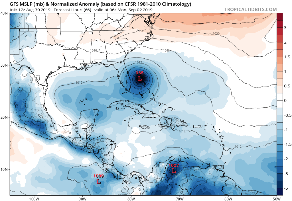
gatorcane wrote:Looks like GFS is headed toward Central Florida
https://i.postimg.cc/nrCjbpK9/gfs-mslpa-Norm-watl-12.png
Yep me likes hopefully it is a start of a trend.
0 likes
-
jlauderdal
- S2K Supporter
- Posts: 7240
- Joined: Wed May 19, 2004 5:46 am
- Location: NE Fort Lauderdale
- Contact:
Re: RE: Re: ATL: DORIAN - Models
That 1020 high appearing on the scene is not good news for the west coast of floridacaneman wrote:Steve wrote:https://www.tropicaltidbits.com/analysis/models/?model=icon®ion=us&pkg=z500_mslp&runtime=2019083012&fh=90
1020mb high in the SE as it's hitting Miami. Looks like a situation where it could get close to 83/84W on this run unless it cuts up Florida or just along the coast.
Dont tell me that crap Steve, we dont need IRMA 2 on the west coast.
2 likes
-
Jevo

- S2K Supporter
- Posts: 1729
- Age: 47
- Joined: Tue Aug 03, 2004 8:45 pm
- Location: The Flemish Cap
- Contact:
Re: ATL: DORIAN - Models
Ahhh great... so now we have the EURO and GFS switching spots as the outlier.... Comeon boys we had consensus 12 hours ago.. I'm going to give the GFS another run before putting any stock in this.. It fizzled a ridge it's been showing for the last 2 days.. The operational run should give us a better idea.
2 likes
Disclaimer: 50% of the time I have no clue of what I am talking about. Chances are I am taking a less than educated guess that sounds good because 10 years ago I stole Mike Watkins book 'The Hurricane and its Impact'. For official information please direct yourself to the NHC and their cadre of weather geniuses.
-
AutoPenalti
- Category 5
- Posts: 4091
- Age: 29
- Joined: Mon Aug 17, 2015 4:16 pm
- Location: Ft. Lauderdale, Florida
Re: ATL: DORIAN - Models
Ridge moves out... Dorian heading WNW.
0 likes
The posts in this forum are NOT official forecasts and should not be used as such. They are just the opinion of the poster and may or may not be backed by sound meteorological data. They are NOT endorsed by any professional institution or STORM2K. For official information, please refer to products from the NHC and NWS.
Model Runs Cheat Sheet:
GFS (5:30 AM/PM, 11:30 AM/PM)
HWRF, GFDL, UKMET, NAVGEM (6:30-8:00 AM/PM, 12:30-2:00 AM/PM)
ECMWF (1:45 AM/PM)
TCVN is a weighted averaged

Re: ATL: DORIAN - Models
SFLcane wrote:gatorcane wrote:Looks like GFS is headed toward Central Florida
https://i.postimg.cc/nrCjbpK9/gfs-mslpa-Norm-watl-12.png
Yep me likes hopefully it is a start of a trend.
I mean...I guess if you are not from Central Florida you can want it to not be a trend...
1 likes
Just like Jon Snow..."I know nothing" except what I know, and most of what I know is gathered by the fine people of the NHC
-
beachman80
Re: ATL: DORIAN - Models
Seems to me the GFS straightens out due west at 72 hours. Surprised it takes it a little north with a strong ridge in place from 24-66 hours.
0 likes

Re: ATL: DORIAN - Models
So ICON is offshore Jax Beach at 165 (valid next Friday at 4am) and moving NE-ish with a ridge now centered around the NY/NH border. Could it kick back in again as a shortcut track storm or will it race off to sea? I can't tell, and the model ends at 180 with it looking like a Cat 2/3 (970mb) at 31.69N, 78.33W or a bit east of the GA/'SC border at the coast and almost due south of the SC/NC border.
0 likes
-
catskillfire51
- S2K Supporter
- Posts: 480
- Age: 39
- Joined: Sun Aug 26, 2012 5:40 pm
- Location: Lake Jackson, TX
Re: ATL: DORIAN - Models
Still due west at 78hrs but north at 84?
Last edited by catskillfire51 on Fri Aug 30, 2019 10:53 am, edited 1 time in total.
0 likes
-
gatorcane

- S2K Supporter
- Posts: 23708
- Age: 48
- Joined: Sun Mar 13, 2005 3:54 pm
- Location: Boca Raton, FL
Re: ATL: DORIAN - Models
GFS 84 hours turning north at the last minute????
Last edited by gatorcane on Fri Aug 30, 2019 10:53 am, edited 1 time in total.
0 likes
-
beachman80
Re: ATL: DORIAN - Models
Wow, did the GFS just do a north jump at 84 hours? Could it miss Florida altogether?
0 likes

Re: ATL: DORIAN - Models
CronkPSU wrote:SFLcane wrote:gatorcane wrote:Looks like GFS is headed toward Central Florida
https://i.postimg.cc/nrCjbpK9/gfs-mslpa-Norm-watl-12.png
Yep me likes hopefully it is a start of a trend.
I mean...I guess if you are not from Central Florida you can want it to not be a trend...
Polk County here. I'll gladly take the hit over my South Florida bros. Then again, i'm not on the coast and i'm sure people in Vero Beach and the like would disagree
1 likes
Who is online
Users browsing this forum: No registered users and 10 guests