Winter Weather Discussion
Moderator: S2k Moderators
Forum rules
The posts in this forum are NOT official forecast and should not be used as such. They are just the opinion of the poster and may or may not be backed by sound meteorological data. They are NOT endorsed by any professional institution or
STORM2K.
-
Gotwood
- Category 2

- Posts: 707
- Joined: Wed Dec 14, 2022 7:18 pm
- Location: Brock Tx
#3721 Postby Gotwood » Thu Jan 22, 2026 9:20 am
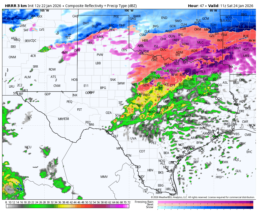
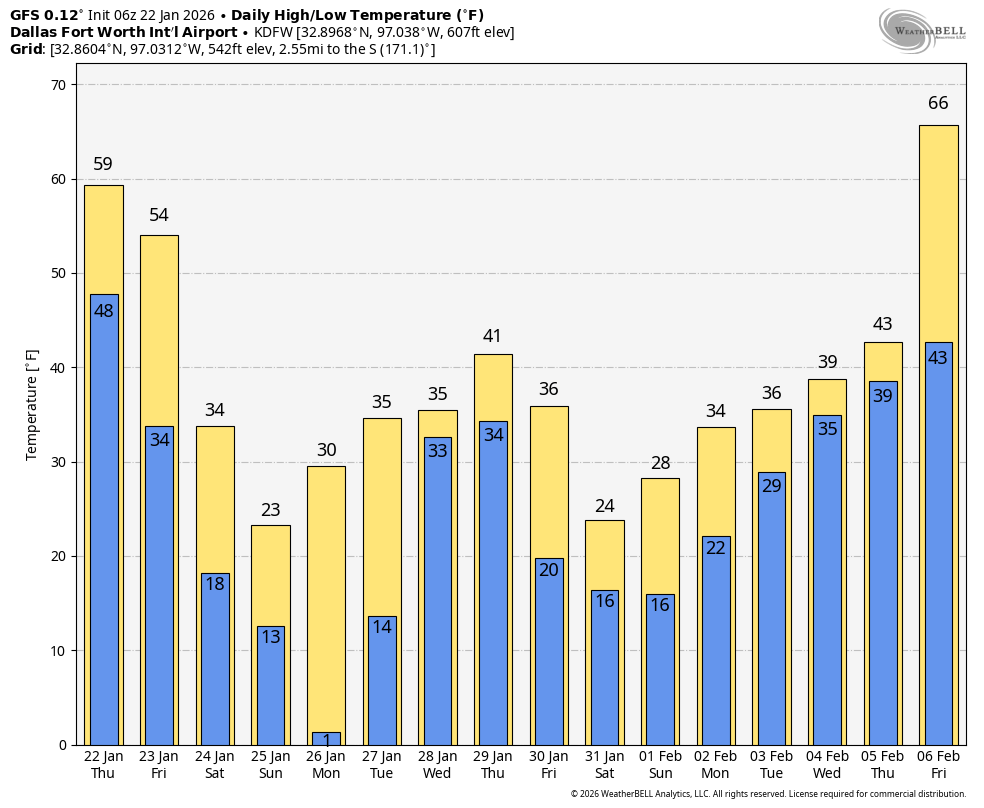
Ntxw wrote:TeamPlayersBlue wrote:Gotwood wrote:I mean if this is true Arctic air I can easily seeing those temps now being forecast to bust on Friday. Lots to see play out.
So i agree. Partially. I agree in a sense of how can a 1052 HP in the US not produce below freezing temps to the Gulf Coast. At the same time, the winds are shunting things to the east and i believe alot of the cold will go with it.
This is the disconnect between the upper flow and surface. Back in 2023 every model (global) led by the Euro was pretty good with the upper flow but struggled with lower level cold, myself, txtwister, and orangeblood had to go against the world because the Euro was mild only to see one of the worse freezing rain icing events in ATX and SAT. If you have a trough that digs into the southwest it allows the cold to bleed. This splitting of the upper flow it has to pick one or the other and often times it is the model that picks the broader cold trough northeast vs the western flank.
So are you thinking the timing for temps to get below freezing is between midnight-3am for the metroplex?
0 likes
-
Gotwood
- Category 2

- Posts: 707
- Joined: Wed Dec 14, 2022 7:18 pm
- Location: Brock Tx
#3722 Postby Gotwood » Thu Jan 22, 2026 9:21 am
Ntxw wrote:orangeblood wrote:This board is wild

. Not sure why/where this narrative of a "bust" is coming from, everything looks to be on track...only question now is about timing of when the transition occurs.
There looks to be 3 waves of precip with this system. It's only the front end batch (Friday/Friday Night) that is in question on when the transition from liquid to frz occurs. But overall, all 3 waves have a substantial amount of QPF occupying them.
This is an Historical Winter Storm for everyone from I-10 North - several DFW Records maybe broken with this storm - Low Max and Low Min on Jan 25 & 26 along with the snowfall record on the 25th as well.
The latest GFS run over the next two weeks is incredible!
Incredible but the real winter fun begins second week of Feb.
https://i.imgur.com/0NlE9BI.png https://i.imgur.com/lhVM8J5.png
I did call V day for winter a couple weeks back lol.
0 likes
-
TomballEd
- Category 5

- Posts: 1178
- Age: 62
- Joined: Wed Aug 16, 2023 4:52 pm
- Location: Spring/Klein area, not Tomball
#3723 Postby TomballEd » Thu Jan 22, 2026 9:22 am
12Z HRRR has DFW area start dropping below freezing about 6 am. Shows mixed precip starting before that.
Yeah, I know, 48 hours is pushing it.
1 likes
-
Ntxw
- Storm2k Moderator

- Posts: 23318
- Joined: Wed Oct 21, 2009 6:34 pm
- Location: DFW, Texas
#3724 Postby Ntxw » Thu Jan 22, 2026 9:25 am
Gotwood wrote:So are you thinking the timing for temps to get below freezing is between midnight-3am for the metroplex?
FV3, WRFs, RGEM, a lot of the short range guidance are bundled between 6z and 12z to fall to freezing and into the 20s by morning Saturday with CAA from the north/northeast. I'd buy into that.
2 likes
The above post and any post by Ntxw is NOT an official forecast and should not be used as such. It is just the opinion of the poster and may or may not be backed by sound meteorological data. It is NOT endorsed by any professional institution including Storm2k. For official information, please refer to NWS products.
Help support Storm2K!
-
Gotwood
- Category 2

- Posts: 707
- Joined: Wed Dec 14, 2022 7:18 pm
- Location: Brock Tx
#3725 Postby Gotwood » Thu Jan 22, 2026 9:28 am
Ntxw wrote:Gotwood wrote:So are you thinking the timing for temps to get below freezing is between midnight-3am for the metroplex?
FV3, WRFs, RGEM, a lot of the short range guidance are bundled between 6z and 12z to fall to freezing and into the 20s by morning Saturday with CAA from the north/northeast. I'd buy into that.
Yeah that’s what I was seeing. What do you think is the cause for pushing back the freezing timeline? I believe at one point we were looking as early at 3pm Friday lol.
0 likes
-
Ntxw
- Storm2k Moderator

- Posts: 23318
- Joined: Wed Oct 21, 2009 6:34 pm
- Location: DFW, Texas
#3726 Postby Ntxw » Thu Jan 22, 2026 9:30 am
Gotwood wrote:Ntxw wrote:Gotwood wrote:So are you thinking the timing for temps to get below freezing is between midnight-3am for the metroplex?
FV3, WRFs, RGEM, a lot of the short range guidance are bundled between 6z and 12z to fall to freezing and into the 20s by morning Saturday with CAA from the north/northeast. I'd buy into that.
Yeah that’s what I was seeing. What do you think is the cause for pushing back the freezing timeline? I believe at one point we were looking as early at 3pm Friday lol.
What was the source? I don't recall forecasts or models showing that?
Earliest I've seen if you assume much strong CAA may be Friday night in the northern counties and out west.
0 likes
The above post and any post by Ntxw is NOT an official forecast and should not be used as such. It is just the opinion of the poster and may or may not be backed by sound meteorological data. It is NOT endorsed by any professional institution including Storm2k. For official information, please refer to NWS products.
Help support Storm2K!

-
Brent
- S2K Supporter

- Posts: 38603
- Age: 37
- Joined: Sun May 16, 2004 10:30 pm
- Location: Tulsa Oklahoma
-
Contact:
#3727 Postby Brent » Thu Jan 22, 2026 9:34 am
To be fair the whole storm has slowed down a bit in general... We don't even get started til probably after dark up here. At one point Friday morning was questionable about whether there would be issues
Of course it now lingers into Sunday too. At one point it was over Saturday. That's really the big trend I've noticed up here. The whole final wave Saturday night didn't appear on the models til a couple days ago
2 likes
#neversummer
-
snownado
- Category 5

- Posts: 1022
- Joined: Sat Dec 09, 2023 7:00 pm
- Location: Plano, TX
#3728 Postby snownado » Thu Jan 22, 2026 9:37 am
If nothing else, it is loooking increasingly likely that much of the widespread wintry precipitation is being delayed until the day on Saturday. This is good in that the evening commute in DFW will be relatively smooth.
Uncertainty still remains with exact surface temps during the daytime on Saturday, as well as precip type (freezing rain vs. sleet).
Last edited by
snownado on Thu Jan 22, 2026 9:43 am, edited 1 time in total.
0 likes
-
TomballEd
- Category 5

- Posts: 1178
- Age: 62
- Joined: Wed Aug 16, 2023 4:52 pm
- Location: Spring/Klein area, not Tomball
#3729 Postby TomballEd » Thu Jan 22, 2026 9:41 am
SETX won't have a memorable event in the immediate Houston metro. Car accidents on rural untreated roads late night Saturday into Sunday, that may happen The 290 corridor outside of the immediate Houston area will see more. San Antonio has a better chance at significant winter precip than Houston does but I don't think they get that much either. It does make Austin for a few hours while some precip is falling.
The warmer probably makes it worse for DFW, it would shift the FZRA line North, and sleet is less dangerous than ice ice every time.
12Zs coming in
0 likes
-
wxman22
- Category 5

- Posts: 1779
- Joined: Mon Jan 30, 2006 12:39 am
- Location: Wichita Falls, TX
-
Contact:
#3730 Postby wxman22 » Thu Jan 22, 2026 9:41 am
3k NAM

Up here it looks like the frozen precip starts around 5-6pm Friday. NW Texas topography at work.

Last edited by
wxman22 on Thu Jan 22, 2026 9:43 am, edited 1 time in total.
3 likes
-
Wthrfan
- Tropical Storm

- Posts: 150
- Joined: Thu Dec 22, 2022 10:49 am
- Location: Edmond,OK
#3731 Postby Wthrfan » Thu Jan 22, 2026 9:42 am
Can anyone recall the approximate page for the link to the video explaining the various maps and terminology? I think it was on Tuesday. I meant to bookmark it, but got busy and next thing I knew it was 15 pages later!
0 likes
-
orangeblood
- S2K Supporter

- Posts: 3825
- Joined: Tue Dec 15, 2009 6:14 pm
- Location: Fort Worth, TX
#3732 Postby orangeblood » Thu Jan 22, 2026 9:42 am
HRRR now into range....similar to GFS with frz transition moving thru the Metroplex before sunrise Saturday (4-6am time frame). Then temps tank from there as wave after wave of light-moderate precip set in until Sunday midday.

3 likes
-
snownado
- Category 5

- Posts: 1022
- Joined: Sat Dec 09, 2023 7:00 pm
- Location: Plano, TX
#3733 Postby snownado » Thu Jan 22, 2026 9:42 am
Ntxw wrote:Gotwood wrote:Ntxw wrote:
FV3, WRFs, RGEM, a lot of the short range guidance are bundled between 6z and 12z to fall to freezing and into the 20s by morning Saturday with CAA from the north/northeast. I'd buy into that.
Yeah that’s what I was seeing. What do you think is the cause for pushing back the freezing timeline? I believe at one point we were looking as early at 3pm Friday lol.
What was the source? I don't recall forecasts or models showing that?
Earliest I've seen if you assume much strong CAA may be Friday night in the northern counties and out west.
Several forecasters early on (including the NWS) did at least indicate a faster frontal passage during the day on Friday was a possibility given past handling of these shallow arctic airmasses.
But ever since the storm has evolved into what it is now (more amped / NW), that outcome seems very unlikely.
Last edited by
snownado on Thu Jan 22, 2026 9:43 am, edited 1 time in total.
1 likes
-
gpsnowman
- S2K Supporter

- Posts: 3291
- Joined: Fri Jan 07, 2011 10:35 am
- Location: Grand Prairie Tx
#3734 Postby gpsnowman » Thu Jan 22, 2026 9:43 am
Man that is a lot of moisture/sleet.
1 likes
-
Haddox12
- Tropical Wave

- Posts: 9
- Joined: Thu Aug 24, 2017 11:02 am
#3735 Postby Haddox12 » Thu Jan 22, 2026 9:45 am
It would be a cool feature if this board displayed your home location with your username. Someone in OKC is freaking out about a blizzard and someone in Houston is bummed about a bust and it’s impossible to know what to expect based on reading through vague conjecture of what one person is expecting in their backyard

3 likes
-
bigddstranny
- Tropical Low

- Posts: 25
- Joined: Sat Jan 30, 2010 3:55 am
- Location: Cedar Park, Tx
#3736 Postby bigddstranny » Thu Jan 22, 2026 9:45 am
orangeblood wrote:This board is wild

. Not sure why/where this narrative of a "bust" is coming from, everything looks to be on track...only question now is about timing of when the transition occurs.
There looks to be 3 waves of precip with this system. It's only the front end batch (Friday/Friday Night) that is in question on when the transition from liquid to frz occurs. But overall, all 3 waves have a substantial amount of QPF occupying them.
This is an Historical Winter Storm for everyone from I-10 North - several DFW Records maybe broken with this storm - Low Max and Low Min on Jan 25 & 26 along with the snowfall record on the 25th as well.
The latest GFS run over the next two weeks is incredible!
https://images.weatherbell.com/meteogram/gfs-deterministic/KDFW/daily_tmin_tmax/1769061600/1769061600-wRa4zuq73Mc.png
Isn't that similar to 2021, though not as cold or long lasting? Or am I "mis-renembering"?
0 likes
-
orangeblood
- S2K Supporter

- Posts: 3825
- Joined: Tue Dec 15, 2009 6:14 pm
- Location: Fort Worth, TX
#3737 Postby orangeblood » Thu Jan 22, 2026 9:45 am
gpsnowman wrote:Man that is a lot of moisture/sleet.
It really is, it looks like it transitions right as the heavy line is moving through. Will be really quick accumulations if this plays out
4 likes
-
Brent
- S2K Supporter

- Posts: 38603
- Age: 37
- Joined: Sun May 16, 2004 10:30 pm
- Location: Tulsa Oklahoma
-
Contact:
#3738 Postby Brent » Thu Jan 22, 2026 9:46 am
gpsnowman wrote:Man that is a lot of moisture/sleet.
Yeah I think that's why there's so much hype up here too even for manageable snow. The signal about the moisture envelope has been crazy
Last edited by
Brent on Thu Jan 22, 2026 9:46 am, edited 1 time in total.
1 likes
#neversummer
-
HockeyTx82
- S2K Supporter

- Posts: 2711
- Joined: Tue Oct 27, 2009 11:17 am
- Location: Ponder, TX
#3739 Postby HockeyTx82 » Thu Jan 22, 2026 9:46 am
This proves my point, haha. We are such a large State and everybody's post is directed towards their specific area, so while one post above may say oh my God it's not going to get below freezing until Saturday, the next can indicate hey it's breaking out Friday afternoon.
Lots of emotions here.

2 likes
Don't hold me accountable for anything I post on this forum. Leave the real forecasting up to the professionals.
Location: Ponder, TX (all observation posts are this location unless otherwise noted)
-
orangeblood
- S2K Supporter

- Posts: 3825
- Joined: Tue Dec 15, 2009 6:14 pm
- Location: Fort Worth, TX
#3740 Postby orangeblood » Thu Jan 22, 2026 9:46 am
bigddstranny wrote:orangeblood wrote:This board is wild

. Not sure why/where this narrative of a "bust" is coming from, everything looks to be on track...only question now is about timing of when the transition occurs.
There looks to be 3 waves of precip with this system. It's only the front end batch (Friday/Friday Night) that is in question on when the transition from liquid to frz occurs. But overall, all 3 waves have a substantial amount of QPF occupying them.
This is an Historical Winter Storm for everyone from I-10 North - several DFW Records maybe broken with this storm - Low Max and Low Min on Jan 25 & 26 along with the snowfall record on the 25th as well.
The latest GFS run over the next two weeks is incredible!
https://images.weatherbell.com/meteogram/gfs-deterministic/KDFW/daily_tmin_tmax/1769061600/1769061600-wRa4zuq73Mc.png
Isn't that similar to 2021, though not as cold or long lasting? Or am I "mis-renembering"?
Very close to 2021 over a 10 day stretch if this came close to verifying
2 likes
Return to “Winter Weather”
Who is online
Users browsing this forum: BigB0882, bigddstranny, Brazoria979cnty, cheezyWXguy, chickypez, Coldandsnow, Cpv17, CSpringer, dhweather, downsouthman1, foulbeast, Golfisnoteasy75, Greener, Harp.1, HockeyTx82, Jag95, JDawg512, LearnedHat, Longhornmaniac8, Ntxw, orangeblood, Quixotic, rwfromkansas, Sambucol2024, Sps123, Stonewood Ranch, Stratton23, techfan012, Texas Snow, WeatherNewbie, WeatherP1, Will_TX, wxman57, Yukon Cornelius and 338 guests