ENSO Updates (2007 thru 2023)

This is the general tropical discussion area. Anyone can take their shot at predicting a storms path.

Moderator: S2k Moderators

Forum rules

The posts in this forum are NOT official forecasts and should not be used as such. They are just the opinion of the poster and may or may not be backed by sound meteorological data. They are NOT endorsed by any professional institution or STORM2K. For official information, please refer to products from the National Hurricane Center and National Weather Service.

Help Support Storm2K
Message
Author
dexterlabio
Category 5
Category 5
Posts: 3468
Joined: Sat Oct 24, 2009 11:50 pm

Re: ENSO Updates

#3841 Postby dexterlabio » Fri Mar 28, 2014 8:48 am

Image


Very warm anomaly showing up near 100W and at the surface. If this keeps up I don't think we're seeing a Modoki in the near term...
0 likes   
Personal Forecast Disclaimer:
The posts in this forum are NOT official forecast and should not be used as such. They are just the opinion of the poster and may or may not be backed by sound meteorological data. They are NOT endorsed by any professional institution or storm2k.org. For official information, please refer to the NHC and NWS products.

User avatar
Ntxw
Storm2k Moderator
Storm2k Moderator
Posts: 22785
Joined: Wed Oct 21, 2009 6:34 pm
Location: DFW, Texas

Re: ENSO Updates

#3842 Postby Ntxw » Fri Mar 28, 2014 9:04 am

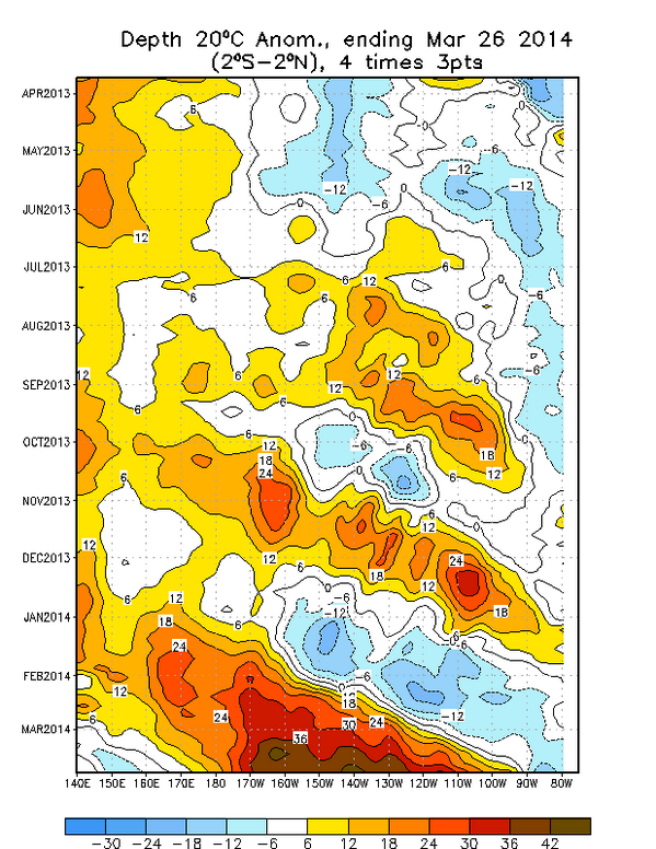
dexterlabio wrote:http://www.cpc.ncep.noaa.gov/products/analysis_monitoring/ocean/anim/wkxzteq_anm.gif


Very warm anomaly showing up near 100W and at the surface. If this keeps up I don't think we're seeing a Modoki in the near term...


Almost carbon copy of 1997. Some resemblance to 1972 as well. Does not get any more El Nino thermocline than that. I think the IRI will raise their odds of El Nino in the April update significantly. Paul Roundy's 80% doesn't look so crazy after all.

Definitely more impressive than 2009 even at its peak
0 likes   
The above post and any post by Ntxw is NOT an official forecast and should not be used as such. It is just the opinion of the poster and may or may not be backed by sound meteorological data. It is NOT endorsed by any professional institution including Storm2k. For official information, please refer to NWS products.

  Help support Storm2K!
Help Support Storm2K

User avatar
xtyphooncyclonex
Category 5
Category 5
Posts: 3861
Age: 23
Joined: Sat Dec 08, 2012 9:07 am
Location: Cebu City
Contact:

#3843 Postby xtyphooncyclonex » Fri Mar 28, 2014 9:25 am

1997 part II? Man, that year had one of the worst Asian droughts!
0 likes   
REMINDER: My opinions that I, or any other NON Pro-Met in this forum, are unofficial. Please do not take my opinions as an official forecast and warning. I am NOT a meteorologist. Following my forecasts blindly may lead to false alarm, danger and risk if official forecasts from agencies are ignored.

User avatar
xtyphooncyclonex
Category 5
Category 5
Posts: 3861
Age: 23
Joined: Sat Dec 08, 2012 9:07 am
Location: Cebu City
Contact:

#3844 Postby xtyphooncyclonex » Fri Mar 28, 2014 10:15 am

All regions are going down. Why is this happening?
0 likes   
REMINDER: My opinions that I, or any other NON Pro-Met in this forum, are unofficial. Please do not take my opinions as an official forecast and warning. I am NOT a meteorologist. Following my forecasts blindly may lead to false alarm, danger and risk if official forecasts from agencies are ignored.

User avatar
TeamPlayersBlue
Category 5
Category 5
Posts: 3445
Joined: Tue Feb 02, 2010 1:44 am
Location: Denver/Applewood, CO

#3845 Postby TeamPlayersBlue » Fri Mar 28, 2014 10:39 am

Geez that warm pool is huge. So is there any clue as to how this begins in the first place? I know this could be a massive mystery but something of this magnitude happening so quickly is incredible.
0 likes   
Personal Forecast Disclaimer:
The posts in this forum are NOT official forecast and should not be used as such. They are just the opinion of the poster and may or may not be backed by sound meteorological data. They are NOT endorsed by any professional institution or storm2k.org. For official information, please refer to the NHC and NWS products.

dexterlabio
Category 5
Category 5
Posts: 3468
Joined: Sat Oct 24, 2009 11:50 pm

Re: ENSO Updates

#3846 Postby dexterlabio » Fri Mar 28, 2014 10:56 am

xtyphooncyclonex wrote:All regions are going down. Why is this happening?


It's not something to raise an eyebrow just yet. There could be slight fluctuation of temp readings on a daily basis and they're not actually a trend.
0 likes   
Personal Forecast Disclaimer:
The posts in this forum are NOT official forecast and should not be used as such. They are just the opinion of the poster and may or may not be backed by sound meteorological data. They are NOT endorsed by any professional institution or storm2k.org. For official information, please refer to the NHC and NWS products.

User avatar
Kingarabian
S2K Supporter
S2K Supporter
Posts: 15981
Joined: Sat Aug 08, 2009 3:06 am
Location: Honolulu, Hawaii

Re:

#3847 Postby Kingarabian » Fri Mar 28, 2014 2:21 pm

xtyphooncyclonex wrote:All regions are going down. Why is this happening?

I don't think it means much. That warm pool is going to remain there for quite some time, so the SST's have no where to go but up.
That's why it's best to look at weekly averages to gauge what's happening. Daily's are always expected to fluctuate.
0 likes   
RIP Kobe Bryant

User avatar
Ntxw
Storm2k Moderator
Storm2k Moderator
Posts: 22785
Joined: Wed Oct 21, 2009 6:34 pm
Location: DFW, Texas

Re: ENSO Updates

#3848 Postby Ntxw » Fri Mar 28, 2014 7:49 pm

dexterlabio wrote:
xtyphooncyclonex wrote:All regions are going down. Why is this happening?


It's not something to raise an eyebrow just yet. There could be slight fluctuation of temp readings on a daily basis and they're not actually a trend.


Some easterlies and MJO still not in the favorable phases for rapid warm up. We are kind of in a La Nina state when looking at the MJO, so things are a little slow. ENSO is a very sloooow process ebb and flow. It took us 2 months just to build the pool and get it halfway through the Pacific! WWB will return, just takes some time it's not going to be a constant rise.

Euro has been hinting at potential cyclone activity in the WPAC. Worth monitoring.

Ocean heat anoms that way continues to rise to near record levels for the time of year when usually it dips

Image

Here was the 1997 April composite. As of late March we are already heading towards it if not there. If not for the cold pool east of 90W it's just eerie how they cooperate.

Image

Includes 3/24 update

Image
0 likes   
The above post and any post by Ntxw is NOT an official forecast and should not be used as such. It is just the opinion of the poster and may or may not be backed by sound meteorological data. It is NOT endorsed by any professional institution including Storm2k. For official information, please refer to NWS products.


  Help support Storm2K!

Help Support Storm2K


User avatar
cycloneye
Admin
Admin
Posts: 145328
Age: 68
Joined: Thu Oct 10, 2002 10:54 am
Location: San Juan, Puerto Rico

Re: ENSO Updates

#3849 Postby cycloneye » Sat Mar 29, 2014 7:52 am

That Kelvin Wave is huge. Here is how Dr Michael Ventrice describes it.

@MJVentrice
20C isotherm depth anom off the charts w/this record-setting downwelling oceanic Kelvin wave. Big east push of warmth.

Image
0 likes   
Visit the Caribbean-Central America Weather Thread where you can find at first post web cams,radars
and observations from Caribbean basin members Click Here

User avatar
Ntxw
Storm2k Moderator
Storm2k Moderator
Posts: 22785
Joined: Wed Oct 21, 2009 6:34 pm
Location: DFW, Texas

#3850 Postby Ntxw » Sat Mar 29, 2014 4:19 pm

Any guesses what the update will be on Monday? I'm going to guess +0.3C, it's been fluctuating between +0.2's and +0.3's

Image

In other news, Euro has been zoning in on a WPAC typhoon. Would be eerie if that happens within the next 2 weeks, and definitely something to think about in the Philippines.
0 likes   
The above post and any post by Ntxw is NOT an official forecast and should not be used as such. It is just the opinion of the poster and may or may not be backed by sound meteorological data. It is NOT endorsed by any professional institution including Storm2k. For official information, please refer to NWS products.


  Help support Storm2K!

Help Support Storm2K


User avatar
Ntxw
Storm2k Moderator
Storm2k Moderator
Posts: 22785
Joined: Wed Oct 21, 2009 6:34 pm
Location: DFW, Texas

Re: ENSO Updates

#3851 Postby Ntxw » Sat Mar 29, 2014 7:10 pm

The ECMWF has been the superior MJO model over the GFS, the american model was confused with the subtropical flare over the Pacific. It correctly advanced the pulse into the IO vs sending it back to 8/1 as in a few weeks ago. The model now predicts the strengthening of the MJO as it advances towards the Maritime Continent much quicker than it's pace the past week. This is our new WWB, think a big Pacific MJO is coming. Probably why this model has been so bullish in typhoon formation.

Image
0 likes   
The above post and any post by Ntxw is NOT an official forecast and should not be used as such. It is just the opinion of the poster and may or may not be backed by sound meteorological data. It is NOT endorsed by any professional institution including Storm2k. For official information, please refer to NWS products.


  Help support Storm2K!

Help Support Storm2K


User avatar
xtyphooncyclonex
Category 5
Category 5
Posts: 3861
Age: 23
Joined: Sat Dec 08, 2012 9:07 am
Location: Cebu City
Contact:

Re: ENSO Updates

#3852 Postby xtyphooncyclonex » Sat Mar 29, 2014 8:51 pm

Just for comparison purposes.

You can clearly see that the sea surface temperatures [SST's] in March 16 have warmed, and those anomalies are even strengthening. 12 days later [March 28], the sea surface temperatures are warming EVEN MORE and the anomalies are pushing east. Those cool anomalies over South America are shrinking and weakening and will be dominated by the warmer waters, by which will be fueled even more by the subsurface warm pool. We could even surpass the anomalies in the MAM timeframe of 1997, and get our first +0.5C anomalies in Nino Regions 3.4 and 3 on early April, as those regions already in warm neutral. and are heading towards El Nino threshold. This will even be fueled by the westerlies enhanced by the phantom storm over the WEST PACIFIC. Meanwhile, Nino Region 1+2 is warming the most rapidly, but is still in LA NINA threshold. But still, it is impossible not to get an El Nino of any kind or intensity. Also, we are seeing warm anomalies now, and may become very powerful at the time the El Nino reaches its peak, and may be one of the most powerful of record.

Image
0 likes   
REMINDER: My opinions that I, or any other NON Pro-Met in this forum, are unofficial. Please do not take my opinions as an official forecast and warning. I am NOT a meteorologist. Following my forecasts blindly may lead to false alarm, danger and risk if official forecasts from agencies are ignored.

User avatar
Ntxw
Storm2k Moderator
Storm2k Moderator
Posts: 22785
Joined: Wed Oct 21, 2009 6:34 pm
Location: DFW, Texas

Re: ENSO Updates

#3853 Postby Ntxw » Sat Mar 29, 2014 9:39 pm

xtyphooncyclonex wrote:Just for comparison purposes.


I agree it's extraordinary what is going on out there. The current warm pool will easily carry El Nino threshold for at least 2 months through early and mid summer. It's enough for us to get to moderate levels for El Nino during that time. WWB's will help but what we have to wait for to get a super El Nino comes the second half. ENSO goes through two transitional phases, first is the spring second is the fall followed by their peak in late fall and winter. Between these two transitions is when we see vulnerability, we've overcome the spring barrier quite easily. 2012 saw the first half go well then could not survive the second half come Aug/Sept. 1997 exploded in the fall after the transition from summer to fall from moderate-strong to super. If we can get moderate established by early summer we'll get tremendous feedback to really sustain it through the transition period.

June 1997 we had a full fledged moderate El Nino

Image

August the pool waned due to the transition of the seasons

Image

By October it exploded into a Super El Nino with resurgence

Image

1982 behaved much the same in a lesser state. 2009 was our most recent El Nino and strongest since 2000. Based on the the warm pool size and evolution I think it's probable we will topple that one as it was not as deep, large, or as warm.
0 likes   
The above post and any post by Ntxw is NOT an official forecast and should not be used as such. It is just the opinion of the poster and may or may not be backed by sound meteorological data. It is NOT endorsed by any professional institution including Storm2k. For official information, please refer to NWS products.


  Help support Storm2K!

Help Support Storm2K


User avatar
Ntxw
Storm2k Moderator
Storm2k Moderator
Posts: 22785
Joined: Wed Oct 21, 2009 6:34 pm
Location: DFW, Texas

Re: ENSO Updates

#3854 Postby Ntxw » Sat Mar 29, 2014 9:57 pm

Speaking of 2009, just for eyeballing purposes at it's peak!

Image

Image
0 likes   
The above post and any post by Ntxw is NOT an official forecast and should not be used as such. It is just the opinion of the poster and may or may not be backed by sound meteorological data. It is NOT endorsed by any professional institution including Storm2k. For official information, please refer to NWS products.


  Help support Storm2K!

Help Support Storm2K


User avatar
xtyphooncyclonex
Category 5
Category 5
Posts: 3861
Age: 23
Joined: Sat Dec 08, 2012 9:07 am
Location: Cebu City
Contact:

#3855 Postby xtyphooncyclonex » Sat Mar 29, 2014 10:32 pm

This warm pool at the subsurface is stronger than of March 1997. :eek:
0 likes   
REMINDER: My opinions that I, or any other NON Pro-Met in this forum, are unofficial. Please do not take my opinions as an official forecast and warning. I am NOT a meteorologist. Following my forecasts blindly may lead to false alarm, danger and risk if official forecasts from agencies are ignored.

User avatar
xtyphooncyclonex
Category 5
Category 5
Posts: 3861
Age: 23
Joined: Sat Dec 08, 2012 9:07 am
Location: Cebu City
Contact:

#3856 Postby xtyphooncyclonex » Sun Mar 30, 2014 5:08 am

My forecast for ASO 2014.

Image

Personal Forecast Disclaimer:
The posts in this forum are NOT official forecast and should not be used as such. They are just the opinion of the poster and may or may not be backed by sound meteorological data. They are NOT endorsed by any professional institution or storm2k.org. For official information, please refer to the NHC and NWS products.
0 likes   
REMINDER: My opinions that I, or any other NON Pro-Met in this forum, are unofficial. Please do not take my opinions as an official forecast and warning. I am NOT a meteorologist. Following my forecasts blindly may lead to false alarm, danger and risk if official forecasts from agencies are ignored.

User avatar
xtyphooncyclonex
Category 5
Category 5
Posts: 3861
Age: 23
Joined: Sat Dec 08, 2012 9:07 am
Location: Cebu City
Contact:

Re: ENSO Updates

#3857 Postby xtyphooncyclonex » Sun Mar 30, 2014 5:10 am

Ntxw wrote:Speaking of 2009, just for eyeballing purposes at it's peak!

Image

Image

IMO, this *upcoming* El Nino will definitely be stronger than 2009! Evidenced by the warm pool's intensity and also the warm pool is expanding and strengthening quickly at an unusual time of year. Going to be at least a strong EL NINO this year.
0 likes   
REMINDER: My opinions that I, or any other NON Pro-Met in this forum, are unofficial. Please do not take my opinions as an official forecast and warning. I am NOT a meteorologist. Following my forecasts blindly may lead to false alarm, danger and risk if official forecasts from agencies are ignored.

User avatar
xtyphooncyclonex
Category 5
Category 5
Posts: 3861
Age: 23
Joined: Sat Dec 08, 2012 9:07 am
Location: Cebu City
Contact:

#3858 Postby xtyphooncyclonex » Sun Mar 30, 2014 5:18 am

1982 was the fastest intensifying. It was supposed to be a weak El Nino, but it turned out to be one of the strongest on record. The warm pool was not yet properly developed but it surprisingly exploded!
0 likes   
REMINDER: My opinions that I, or any other NON Pro-Met in this forum, are unofficial. Please do not take my opinions as an official forecast and warning. I am NOT a meteorologist. Following my forecasts blindly may lead to false alarm, danger and risk if official forecasts from agencies are ignored.

stormkite
S2K Supporter
S2K Supporter
Posts: 672
Joined: Fri Sep 13, 2013 3:59 am

#3859 Postby stormkite » Sun Mar 30, 2014 8:30 am

Image

Its barreling along
0 likes   

User avatar
Portastorm
Storm2k Moderator
Storm2k Moderator
Posts: 9914
Age: 63
Joined: Fri Jul 11, 2003 9:16 am
Location: Round Rock, TX
Contact:

Re: ENSO Updates

#3860 Postby Portastorm » Sun Mar 30, 2014 10:23 am

Interesting blurb from an article on the Mashable website which speaks to the likelihood of an El Nino and possibly a strong one:

One problem that forecasters encounter when trying to foresee the likelihood and intensity of El Niño events is that there is limited historical data of the vast Pacific Ocean. Observational data only dates back to about 1990, Roundy says.

Making matters more difficult for forecasters is the recent degradation of a crucial buoy network used for El Niño and La Niña monitoring. Budget cuts have led to missing data, with the network known as the Tropical Atmosphere Ocean Project, or TAO array, operating at just 30 to 40% percent of capacity.
0 likes   
Any forecasts under my name are to be taken with a grain of salt. Get your best forecasts from the National Weather Service and National Hurricane Center.


Return to “Talkin' Tropics”

Who is online

Users browsing this forum: No registered users and 32 guests