
ATL: ISAAC - Post-Tropical - Discussion
Moderator: S2k Moderators

Re: ATL: ISAAC - Tropical Storm - Discussion
Looks NW to me. It seems like it will clip Cuba but not by much. Also the last point puts it in the windward passage.

Uploaded with ImageShack.us

Uploaded with ImageShack.us
Last edited by blp on Sat Aug 25, 2012 7:00 am, edited 1 time in total.
0 likes
The following post is NOT an official forecast and should not be used as such. It is just the opinion of the poster and may or may not be backed by sound meteorological data. It is NOT endorsed by any professional institution including storm2k.org For Official Information please refer to the NHC and NWS products.

Re: ATL: ISAAC - Tropical Storm - Discussion
2am model plots with 8am position of Isaac...he is east of the model runs from just 6 hours ago. If he can maintain the 315 or 320 deg heading and not slow down any, he will clear the tip of Cuba in a few hours.

0 likes

Re: ATL: ISAAC - Tropical Storm - Discussion
what the heck is that thing in the Keys right now and how will it affect the future path of Isaac???
0 likes
Just like Jon Snow..."I know nothing" except what I know, and most of what I know is gathered by the fine people of the NHC
-
meriland23

- Category 5

- Posts: 1239
- Age: 38
- Joined: Mon Aug 29, 2011 9:29 pm
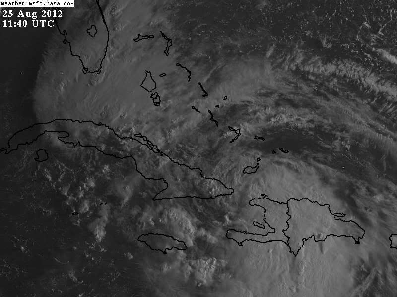
guy above had a good loop, I saved last image and circled around center, and outlined W haiti and E cuba cause it was very faint.. took my a while to find that center! lol

0 likes
The posts in this forum are NOT official forecast and should not be used as such. They are just the opinion of the poster and may or may not be backed by sound meteorological data. They are NOT endorsed by any professional institution or storm2k.org. For official information, please refer to the NHC and NWS products.
-
MiamiensisWx
Re: ATL: ISAAC - Tropical Storm - Discussion
CronkPSU wrote:what the heck is that thing in the Keys right now and how will it affect the future path of Isaac???
It is actually a surface trough that according to the NWS has developed a vorticity maximum overnight. This was poorly handled by the models and might conceivably drag Isaac farther north, leading to a landfall closer to Miami. The good news is that outflow from the feature is shearing Isaac and might significantly reduce its prospects of becoming a hurricane before striking SE FL, as Isaac, having a small core, would be vulnerable to such shear.
Excerpt from NWS Key West Area Forecast Discussion:
IN THE WATER VAPOR IT LOOKS LIKE THERE IS A VORT MAX FORMING OVER THE
FLORIDA STRAITS THAT COULD HAVE SOME IMPACT ON ISSAC AT LEAST IN THE
SHORT TERM.
ALSO...THIS FEATURE MAY HAVE BEEN THE CULPRIT FOR THE COLD
POOL ALOFT PRODUCING 40 TO 45 KNOTS WINDS ACROSS THE STRATOFORM RAIN
SHIELD OVER THE KEY ISLAND CHAIN AND COASTAL WATERS BEFORE MIDNIGHT.
FROM A RECENT ASCAT SATELLITE PASS THE WINDS ON THE SOUTHEASTERN EDGE
OF THE STORM ARE QUITE LIGHT...POSSIBLY DUE TO THE DOWN SLOPING WINDS
CUTTING OFF THE INFLOW TO THAT AREA OF ISSAC. THE INTERACTION OF
THESE MESOSCALE FEATURES ON THE SYNOPTIC SCALE ISSAC ARE GOING TO BE
THE KEY IN THE EVOLUTION OF ISSAC AS THE STORM CROSSES OVER THE NORTH
EDGE OF THE LAND MASS...HAITI AND CUBA.
Edit: Link
Of course this is my own opinion and is not an official forecast.
Last edited by MiamiensisWx on Sat Aug 25, 2012 7:15 am, edited 2 times in total.
0 likes
Re: ATL: ISAAC - Tropical Storm - Discussion
Monroe County Emergency Management is now making a strong recommendation that visitors to the Florida Keys leave the county if they are able to do so safely. Tropical Storm Force winds will begin to hit the island chain on Sunday morning, so those who can leave should do so this morning.
Key West International Airport will be stopping commercial air traffic Saturday evening at 7 p.m. and all day Sunday.
Key West International Airport will be stopping commercial air traffic Saturday evening at 7 p.m. and all day Sunday.
0 likes

Re: ATL: ISAAC - Tropical Storm - Discussion
@CronkPSU, someone mentioned earlier that Andrew "chased" a blob in directionality...but I would take that with a grain of salt. IMHO, looks like he will shoot through Hurricane Alley, the worry will be a bend back towards Tampa if some of the latest model trends of NE move at the end of his run prior to landfall. I have not seen any tweets on loss of life in Haiti as of yet, worth a mention ATP.
Personal Forecast Disclaimer:
The posts in this forum are NOT official forecast and should not be used as such. They are just the opinion of the poster and may or may not be backed by sound meteorological data. They are NOT endorsed by any professional institution or storm2k.org. For official information, please refer to the NHC and NWS products.
0 likes
Re: ATL: ISAAC - Tropical Storm - Discussion
thanks @miamiensisWX and @TexasF6....i was thinking that may be the reason for the shoddy looking Isaac eastern quadrant, wasn't sure if it could hurt the ridging as well in terms of direction
0 likes
Just like Jon Snow..."I know nothing" except what I know, and most of what I know is gathered by the fine people of the NHC
-
HurricaneAndrew92
Re: ATL: ISAAC - Tropical Storm - Discussion
Red circle is approx center, red arrows are potential movement, and green circle is where we may see hurricane Isaac.


0 likes
-
adam0983
Re: ATL: ISAAC - Tropical Storm - Discussion
It seems that Isaac will miss cuba on the latest nnw jog. This storm is much further east than any of other tracks. Joe Bastardi says that this storm will miss cuba and will come more towards the north. Does anyone think that this trend to more of an east track to continue. Does this new trend mean a stronger storm and a stronger storm for metro broward, dade and palm beach? Just an opinion not a forcast.
0 likes
-
wzrgirl1

- S2K Supporter

- Posts: 1360
- Joined: Sat Sep 04, 2004 6:44 am
- Location: Pembroke Pines, Florida
Re: ATL: ISAAC - Tropical Storm - Discussion
Isaac is looking quite ragged this morning. Anyone else concur?
0 likes
-
MiamiensisWx
Re: ATL: ISAAC - Tropical Storm - Discussion
adam0983 wrote:It seems that Isaac will miss cuba on the latest nnw jog. This storm is much further east than any of other tracks. Joe Bastardi says that this storm will miss cuba and will come more towards the north. Does anyone think that this trend to more of an east track to continue. Does this new trend mean a stronger storm and a stronger storm for metro broward, dade and palm beach? Just an opinion not a forcast.
The posts in this forum are NOT official forecast and should not be used as such. They are just the opinion of the poster and may or may not be backed by sound meteorological data. They are NOT endorsed by any professional institution or storm2k.org. For official information, please refer to the NHC and NWS products.
I do not think it means a stronger storm as the convective complex off the Keys will likely shear the system and prevent Isaac from reorganizing into a hurricane in SE FL, but the same complex could draw it north into the Miami area, increasing winds over Broward and Palm Beach counties. The evolution of the convection off the Keys is just the latest surprise in the life of Isaac and may be good news for S FL in terms of predicating the intensity of Isaac. I think the more eastward track is becoming increasingly irrelevant if shear remains or increases.
Last edited by MiamiensisWx on Sat Aug 25, 2012 7:28 am, edited 3 times in total.
0 likes
Re: ATL: ISAAC - Tropical Storm - Discussion
wzrgirl1 wrote:Isaac is looking quite ragged this morning. Anyone else concur?
Not as bad as I thought he was going to be this morning, it is quickly gaining organization with the pressure now down to 998mb.
0 likes
-
tolakram
- Admin

- Posts: 20176
- Age: 62
- Joined: Sun Aug 27, 2006 8:23 pm
- Location: Florence, KY (name is Mark)
Re: ATL: ISAAC - Tropical Storm - Discussion
Rapid scan live loops
zoom 1: http://wwwghcc.msfc.nasa.gov/cgi-bin/ge ... umframes=5
zoom 2: http://wwwghcc.msfc.nasa.gov/cgi-bin/ge ... umframes=5
zoom 1: http://wwwghcc.msfc.nasa.gov/cgi-bin/ge ... umframes=5
zoom 2: http://wwwghcc.msfc.nasa.gov/cgi-bin/ge ... umframes=5
0 likes
M a r k
- - - - -
Join us in chat: Storm2K Chatroom Invite. Android and IOS apps also available.
The posts in this forum are NOT official forecasts and should not be used as such. Posts are NOT endorsed by any professional institution or STORM2K.org. For official information and forecasts, please refer to NHC and NWS products.
-
wzrgirl1
- S2K Supporter
- Posts: 1360
- Joined: Sat Sep 04, 2004 6:44 am
- Location: Pembroke Pines, Florida
Re: ATL: ISAAC - Tropical Storm - Discussion
Any chances Isaac could fall apart or is that far fetched at this point because the circulation is well intact?
0 likes
-
wxman57

- Moderator-Pro Met

- Posts: 23171
- Age: 68
- Joined: Sat Jun 21, 2003 8:06 pm
- Location: Houston, TX (southwest)
Re: ATL: ISAAC - Tropical Storm - Discussion
CronkPSU wrote:what the heck is that thing in the Keys right now and how will it affect the future path of Isaac???
That's the upper-level trof that induced the current NW movement of Isaac. It should be lifting out to the north today as Isaac approaches.
0 likes
Who is online
Users browsing this forum: No registered users and 19 guests