SE TX/SW LA weather: Much cooler and WET after Tuesday

U.S. & Caribbean Weather Discussions and Severe Weather Events

Moderator: S2k Moderators

Forum rules

The posts in this forum are NOT official forecast and should not be used as such. They are just the opinion of the poster and may or may not be backed by sound meteorological data. They are NOT endorsed by any professional institution or STORM2K.

Help Support Storm2K
Message
Author
User avatar
jasons2k
Storm2k Executive
Storm2k Executive
Posts: 8245
Age: 51
Joined: Wed Jul 06, 2005 12:32 pm
Location: The Woodlands, TX

Re:

#3861 Postby jasons2k » Sat Sep 19, 2009 11:33 am

CajunMama wrote:The humidity is killing me already! I was just outside, just standing around and i'm drenched already. It's going to be a long day outside. Bre and her family along with my daughter and i are heading to baton rouge in a couple of hours for an afternoon of tailgating and an evening of cajun and tiger football.


Have fun at the game - that sounds like a great time!

My Red Raiders are on National TV tonight and my Cowboys are on NBC Sunday Night Football tomorrow. Just football heaven for me :-)
0 likes   

User avatar
southerngale
Retired Staff
Retired Staff
Posts: 27418
Joined: Thu Oct 10, 2002 1:27 am
Location: Southeast Texas (Beaumont area)

#3862 Postby southerngale » Sat Sep 19, 2009 11:48 am

The predicted high for today has wavered around a lot. I'm hoping it's on the lower side of the predictions. We'll be outside most of the afternoon/evening for a birthday bash here. I could do without the high humidity, but with a water balloon fight in the plans, at least a chance to cool off. :P
0 likes   

User avatar
srainhoutx
S2K Supporter
S2K Supporter
Posts: 6919
Age: 67
Joined: Sun Jan 14, 2007 11:34 am
Location: Haywood County, NC
Contact:

Re: SE TX/SW LA weather: A fall-like pattern?

#3863 Postby srainhoutx » Sat Sep 19, 2009 3:07 pm

Hope all are enjoyng the weekend. Next week looks iffy at best...

AREA FORECAST DISCUSSION
NATIONAL WEATHER SERVICE HOUSTON/GALVESTON TX
302 PM CDT SAT SEP 19 2009

.DISCUSSION...
RADAR QUIET SO FAR BUT THE POSSIBILITY EXISTS FOR A FEW
-SHRA/-TSRA TO DEVELOP ALONG THE SEABREEZE. PESKY UPPER TROUGH
WILL FINALLY BEGIN TO PUSH AWAY FROM THE AREA SUNDAY JUST IN TIME
FOR ANOTHER ONE TO DROP INTO THE SOUTHERN PLAINS AND TAKE ITS
PLACE NEXT WEEK. SFC WINDS WILL SWITCH BACK TO AN ONSHORE
DIRECTION BEGINNING SUNDAY IN RESPONSE TO THE APPROACHING SYSTEM.
MOISTURE LEVELS WILL BEGIN TO INCREASE AGAIN WITH PWS REACHING 2
INCHES OVER THE SRN ZONES...ALONG WITH HIGHER HUMIDITY LEVELS. GFS
BUFR SOUNDINGS SHOW LITTLE TO NO CAPPING ON SUNDAY AND MONDAY WITH
K-INDICES IN THE LOW/MID 30S AND CONVECTIVE TEMPS IN THE MID/UPPER
80S. GIVEN THE HIGH PWS HAVE PLACED 30 POPS FOR SRN ZONES SUNDAY
AND AREA WIDE ON MONDAY WITH DIURNAL CONVECTIVE DEVELOPMENT
EXPECTED. TEMPS/HUMIDITY WILL BE BACK TO LATE SUMMER LEVELS
THROUGH MONDAY.

HAVE LEANED TOWARD THE 12Z ECMWF SOLUTION FOR THE HANDLING OF THE
STRONG UPPER LOW FORECAST TO CUT OFF OVER THE SRN PLAINS BY THE
MIDDLE OF NEXT WEEK. THE 12Z CANADIAN/UKMET SOLUTIONS STRONGLY
SUPPORT THE ECMWF AND IT HAS SUPPORT FROM THE GFS ENSEMBLE MEAN AS
WELL. HAVE BASICALLY THROWN OUT THE OPERATIONAL 12Z GFS SOLUTION
AS IT IS MUCH FURTHER WEST WITH THE LOW. A COLD FRONT IN
ASSOCIATION WITH THIS SYSTEM IS EXPECTED TO CROSS SE TX TUESDAY
BEFORE STALLING NEAR OR JUST OFF THE COAST FOR SEVERAL DAYS. THE
FRONT WILL BE A VERY SHALLOW ONE...AND HIGH MOISTURE LEVELS (PWS
2.1-2.4 INCHES) ARE EXPECTED TO POOL OVER SE TX IN VICINITY OF THE
BOUNDARY TUESDAY THROUGH FRIDAY. FLOW ALOFT WILL REMAIN DIFFLUENT
THROUGH THE PERIOD IN ADVANCE OF THE UPPER TROUGH. HAVE BASICALLY
KEPT SKIES MOSTLY CLOUDY AND BLANKETED CHANCE TO HIGH CHANCE POPS
AREA WIDE THROUGH THE PERIOD. SOUNDING PROFILES DO NOT REALLY
SUPPORT SEVERE WEATHER BUT LOCALLY HEAVY RAINFALL WILL BE POSSIBLE
THROUGH THIS PERIOD. 850 MB BOUNDARY WILL REMAIN IN PLACE OVER SE
TX AND COULD SERVE AS A FOCUS FOR ENHANCED CONVECTIVE DEVELOPMENT
. THE
COOLING EFFECT WITH THE FRONT WILL BE MINIMAL EXCEPT THAT
CLOUDS/RAIN WILL KEEP MAX TEMPS DOWN TUESDAY THROUGH FRIDAY. PER
ECMWF SOLUTION...TROUGH AXIS FINALLY SWINGS EAST OF THE AREA
EARLY SATURDAY...WITH DRIER WEATHER NEXT WEEKEND IN THE WAKE OF
THE SYSTEM. HOWEVER...KEPT 20 POPS GOING NEXT WEEKEND GIVEN THE
POTENTIAL FOR ADDITIONAL MODEL FLUCTUATIONS.

35
0 likes   

User avatar
Portastorm
Storm2k Moderator
Storm2k Moderator
Posts: 9914
Age: 63
Joined: Fri Jul 11, 2003 9:16 am
Location: Round Rock, TX
Contact:

Re: SE TX/SW LA weather: A fall-like pattern?

#3864 Postby Portastorm » Sat Sep 19, 2009 4:12 pm

Do you SE Texans ever follow Larry Cosgrove, a private industry meteorologist based out of Houston? I have seen many references to him on the Eastern forum and starting following his daily posts on the link below. Interesting that the guy was harping on the possibility of Marty (Pacific) and his moisture moving over Texas and impacting the weather. After an initial mention of it last weekend, most NWS offices ignored that possibility during the week. Well, Cosgrove nailed it as the moisture is impacting us in south central Texas and bumped our chances of showers upward.

Anyhow, just curious what his following is from my fellow S2Kers down 290.

http://www.examiner.com/x-3775-Houston-Weather-Examiner~y2009m9d17-Weekend-Weather-Forecast-For-Houston-TX-And-Vicinity-Friday-September-18-2009
0 likes   

CajunMama
Retired Staff
Retired Staff
Posts: 10791
Joined: Thu Feb 06, 2003 9:57 pm
Location: 30.22N, 92.05W Lafayette, LA

Re: Re:

#3865 Postby CajunMama » Sun Sep 20, 2009 12:52 am

jasons wrote:
CajunMama wrote:The humidity is killing me already! I was just outside, just standing around and i'm drenched already. It's going to be a long day outside. Bre and her family along with my daughter and i are heading to baton rouge in a couple of hours for an afternoon of tailgating and an evening of cajun and tiger football.


Have fun at the game - that sounds like a great time!

My Red Raiders are on National TV tonight and my Cowboys are on NBC Sunday Night Football tomorrow. Just football heaven for me :-)


LOL..you corrected my tigger? That's what we call them...the tiggers!

I swear i sweated out every ounce of fluid in my body. It was absolutely horrible. I was drenched with sweat from 3-9pm. There was a slight breeze every once in awhile but other than that the air was so thick and humid.
0 likes   

User avatar
srainhoutx
S2K Supporter
S2K Supporter
Posts: 6919
Age: 67
Joined: Sun Jan 14, 2007 11:34 am
Location: Haywood County, NC
Contact:

Re: SE TX/SW LA weather: A fall-like pattern?

#3866 Postby srainhoutx » Sun Sep 20, 2009 10:41 am

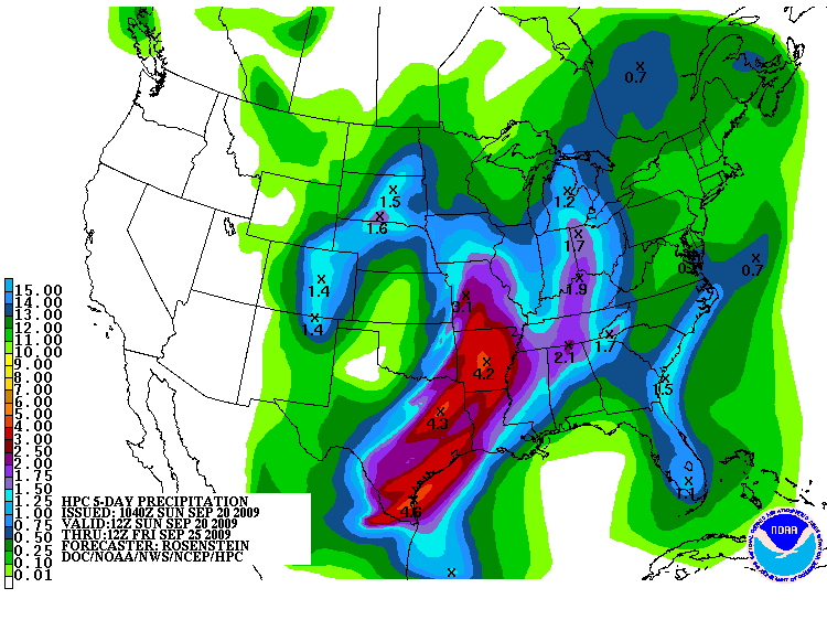
Things continue to look interesting for the upcoming week. Guidance is beginning to come into better agreement concerning the Cold Front and another pesky cutoff Upper Low. Latest 12Z NAM is in better agreement with GFS Ensembles, CMC, and ECMWF operational output. It appears the Cold Front will make it just offshore and stall. What we do not know is just how far S the front will push. The Upper Low is now taking shape in the Pacific NW and dragging a strong early season Cold Front SSE in the Northern Rockies. Current guidance suggest that the Upper Low will cutoff from the northern jetstream and park somewhere near the Southern Plains. The front will likely spark some severe weather in the form of a squall line that will sweep across TX. The fly in the ointment is the Upper Low. If guidance varifies, we may see some short wave disturbances rotate in to the area. With a strong moisture feed in the upper SW wind flow beneath the Upper Low from remnants of Marty and 98E in the EPAC with some rounds of heavy rainfall ahead for drought parched areas of TX as well as SE TX and SW LA if things work out. Something to keep an eye on in the upcoming week.

Image
0 likes   

User avatar
srainhoutx
S2K Supporter
S2K Supporter
Posts: 6919
Age: 67
Joined: Sun Jan 14, 2007 11:34 am
Location: Haywood County, NC
Contact:

Re: SE TX/SW LA weather: A fall-like pattern?

#3867 Postby srainhoutx » Sun Sep 20, 2009 3:38 pm

HGX update concerning the Cold Front and Cut Off Upper Low. Certainly looks wet for many folks.

AREA FORECAST DISCUSSION
NATIONAL WEATHER SERVICE HOUSTON/GALVESTON TX
325 PM CDT SUN SEP 20 2009

.DISCUSSION...
AS NOTED EARLIER...MOISTURE HAS INCREASED ACROSS SE TX AND THERE
ARE A FEW ISO THUNDERSTORMS BETWEEN KLBX AND KBYY ALONG THE
COAST. ISO THUNDERSTORMS SHOULD CONTINUE THROUGH THE
AFTERNOON/EVENING BUT LIKELY BE CONFINED TO COASTAL AREAS.
MOISTURE WITH PRECIP WATER ABOVE 2 INCHES WILL LIKELY REMAIN OVER
SE TX THROUGH TUE. THIS MAY ALLOW FOR BETTER COVERAGE AND MORE
SCATTERED ACTIVITY ON MONDAY. THE FORECAST WILL STICK WITH 30/40
POPS FOR SE TX AND SEE NO NEED TO CHANGE THAT.

UPPER LEVEL ANALYSIS SHOWS A BROAD TROUGH OVER THE C PLAINS WITH
A WEAK SHORTWAVE MOVING ACROSS TX. THE MAIN WEATHER FEATURE THAT
WILL PROVE CHALLENGING TO FORECAST IS THE UPPER LEVEL TROUGH OVER
THE INTER-MOUNTAIN WEST AND W CANADA. FORECAST MODELS ARE
CONSISTENT WITH BRINGING THIS TROUGH INTO THE C PLAINS ON TUE. A
COLD FRONT WITH THIS TROUGH WILL ALSO PUSH INTO SE TX AND ALLOW
FOR SLIGHTLY BELOW NORMAL TEMPERATURES. POST FRONTAL AIRMASS WILL
BE SHALLOW FOR WEAK ISENTROPIC LIFT OVER THE FRONT WILL LIKELY
SUPPORT ELEVATED THUNDERSTORMS GIVEN DEEP MOISTURE AND ELEVATED
INSTABILITY. MODELS REALLY HIT ON A WIDESPREAD PRECIP EVENT SO 60
POPS MAYBE EVEN 70 POPS WILL BE NEEDED TUE. HEAVY RAINFALL WILL
BE THE MAIN THREAT AND SUSPECT THAT THERE IS A CHANCE SOME CELLS
COULD TRAIN ALONG THE FRONTAL BOUNDARY OR OVER THE TOP OF THE
COOLER AIRMASS. THE 850MB FRONT DOES LAG FARTHER NORTH OF THE
AREA AND WESTERLY UPPER LEVEL WINDS SHOULD SUPPORT THE POTENTIAL
OF STORMS RE-GENERATING OVER SE TX.

AFTER TUESDAY...ALL FORECAST CONFIDENCE IS LOST. THE GFS
CONTINUES ITS TREND TO RETROGRADE THE CLOSED LOW OVER THE PLAINS
BACK TO THE CENTRAL ROCKIES. THE GFS ENSEMBLE HAD NOT BEEN IN
SUPPORT OF THIS BUT ARE COMING AROUND TO THIS IDEA. THE ECMWF IS
CONTENT TO STILL KEEP THE CLOSED LOW OVER THE PLAINS WED THROUGH
THE END OF THE WEEK. GIVEN A STRONG RIDGE THAT WILL DEVELOP OVER
THE PAC NW...DOUBT THAT THE LOW WILL RETROGRADE AS MUCH AS THE
GFS THINKS. WITH THAT IN MIND...THE FORECAST HAS BEEN TRENDED
SOMEWHAT TO THE ECMWF SOLUTION KEEPING TEMPS COOLER THAN THE GFS
AND KEEPING THUNDERSTORM CHANCES GOING THROUGH THE END OF THE
WEEK. BOTH THE GFS AND ECMWF BRING A STRONGER COLD FRONT IN TO
THE REGION BY THE END OF THE COMING WEEK BUT THE ECMWF IS FASTER.
IF THE ECMWF IS MORE RIGHT...COULD SEE DRIER CONDITIONS OVER THE
WEEKEND AND WILL KEEP 20 POPS GOING WHICH IS QUITE A BIT LOWER
THAN WHAT THE GFS SUGGESTS.
0 likes   

User avatar
southerngale
Retired Staff
Retired Staff
Posts: 27418
Joined: Thu Oct 10, 2002 1:27 am
Location: Southeast Texas (Beaumont area)

Re: SE TX/SW LA weather: A fall-like pattern?

#3868 Postby southerngale » Sun Sep 20, 2009 4:44 pm

srainhoutx wrote:HGX update concerning the Cold Front and Cut Off Upper Low. Certainly looks wet for many folks.


I'll believe it when I see it falling. ;)

But thanks for keeping us informed.... I enjoy reading the updates.

Quite toasty, and very humid, but otherwise a beautiful weekend. We've had a lot of friends and family over, rented a moonwalk for a party, and spent a lot of time outdoors. We had a water balloon fight yesterday to cool things off. It's been a great weekend! And to top things off... Cowboys football tonight!! Image
0 likes   

User avatar
vbhoutex
Storm2k Executive
Storm2k Executive
Posts: 29113
Age: 73
Joined: Wed Oct 09, 2002 11:31 pm
Location: Cypress, TX
Contact:

Re: SE TX/SW LA weather: A fall-like pattern?

#3869 Postby vbhoutex » Sun Sep 20, 2009 5:22 pm

southerngale wrote:
srainhoutx wrote:HGX update concerning the Cold Front and Cut Off Upper Low. Certainly looks wet for many folks.


I'll believe it when I see it falling. ;)

But thanks for keeping us informed.... I enjoy reading the updates.

Quite toasty, and very humid, but otherwise a beautiful weekend. We've had a lot of friends and family over, rented a moonwalk for a party, and spent a lot of time outdoors. We had a water balloon fight yesterday to cool things off. It's been a great weekend! And to top things off... Cowboys football tonight!! Image

Our weather has been very nice for the weekend even though it is ending on a somewhat cloudy note. A few showers around and a sea breeze front at the coast. I haven't been watching the weather too much today so I have no idea if it will make it this far North. And to top it off.. The Texans beat the Titans this afternoon. Overall a good weekend!!
0 likes   

User avatar
Diva
S2K Supporter
S2K Supporter
Posts: 205
Joined: Fri Jun 16, 2006 11:46 am
Location: Orange, TX

Re: SE TX/SW LA weather: A fall-like pattern?

#3870 Postby Diva » Sun Sep 20, 2009 5:37 pm

southerngale wrote:
I'll believe it when I see it falling. ;)


You and me both! They really need to stop teasing us with all this talk of "drenching rain". :roll: It's just a cruel joke! :cheesy:
0 likes   

SaskatchewanScreamer

#3871 Postby SaskatchewanScreamer » Sun Sep 20, 2009 11:08 pm

Western Canada (Alberta in particular) may just send down what you are hoping for:

Weather Warnings
Environment Canada Logo
:thermo: Alberta :thermo:

* Frost warning for Airdrie - Cochrane - Olds - Sundre

* Frost warning for Brooks - Strathmore - Vulcan

* Frost warning for Cardston - Fort Macleod - Magrath

* Frost warning for City of Calgary

* Frost warning for Drayton Valley - Devon - Rimbey - Pigeon Lake

* Frost warning for Drumheller - Three Hills

* Frost warning for Fort Saskatchewan - Vegreville - Redwater - Smoky Lake

* Frost warning for Leduc - Camrose - Wetaskiwin - Tofield

* Frost warning for Lethbridge - Taber - Milk River

* Frost warning for Okotoks - High River - Claresholm

* Frost warning for Red Deer - Ponoka - Innisfail - Stettler

* Frost warning for Rocky Mountain House - Caroline

* Frost warning for Spruce Grove - Morinville - Mayerthorpe - Evansburg

* Frost warning for Westlock - Barrhead - Athabasca

* Frost warning for Whitecourt - Edson - Fox Creek - Swan Hills
0 likes   

User avatar
Tireman4
S2K Supporter
S2K Supporter
Posts: 5853
Age: 59
Joined: Fri Jun 30, 2006 1:08 pm
Location: Humble, Texas
Contact:

#3872 Postby Tireman4 » Mon Sep 21, 2009 9:25 am

We will take it Mr Screamer.
0 likes   

SaskatchewanScreamer

#3873 Postby SaskatchewanScreamer » Mon Sep 21, 2009 11:28 am

Mrs actually (and the name comes from the blizzards that blow through here not my personality :wink: )

Kinda figured you folks would be happy (ecstatic) to see the above (Alberta however isn't).
0 likes   

User avatar
Tireman4
S2K Supporter
S2K Supporter
Posts: 5853
Age: 59
Joined: Fri Jun 30, 2006 1:08 pm
Location: Humble, Texas
Contact:

#3874 Postby Tireman4 » Mon Sep 21, 2009 11:42 am

I so sorry ma'am. Forgive me. In the heat and humidity that is Houston, I lost my faculties. LOL
0 likes   

User avatar
srainhoutx
S2K Supporter
S2K Supporter
Posts: 6919
Age: 67
Joined: Sun Jan 14, 2007 11:34 am
Location: Haywood County, NC
Contact:

Re: SE TX/SW LA weather: A fall-like pattern?

#3875 Postby srainhoutx » Mon Sep 21, 2009 2:00 pm

Afternoon e-mail from Jeff Lindner...

Much advertise cold front will move into SE TX Tuesday and then stall across the region with heavy rainfall possible Tuesday-Thursday.

Moist air mass resides across the area with PWS in the 1.8-2.0 inch range. Given a little additional heating expect to see a scattering of shower develop…as we already see in Wharton and Fort Bend Counties. Cold front drops southward tonight and enters the area on Tuesday as PWS rise in the 2.0-2.3 inch range. Lift along the front will be significant and expect widespread showers and thunderstorms. SE moving boundary begins to slow as it moves into the region leading to the increased threat for cell training as the front becomes increasingly parallel to the upper level winds. Not all that confident on where the boundary will end up stalling out as the models show varying solutions with the NAM offshore and the GFS inland along the coast. For now will take the difference and indicate the surface boundary making it south of US 59, but remaining just inland…the boundary could be forced off the coast by outflow boundaries. 850mb front hangs up between Victoria and Houston to Austin and College Station. Extensive moisture will ride up and over the frontal slopes as an upper level storm system over CO induces WSW to SW upper level flow atop the cooler air mass at the surface. Expect widespread rains to continue in the post frontal air mass with the heaviest rains focused along the boundaries in the area.

Sub-tropical jet stream will help induce coastal surface reflection on the front along the middle TX coast around Rockport. This will greatly enhance lift Wednesday as this feature moves NE along the surface front. Expect the heaviest rains to focus Tuesday with the frontal passage and then near the coast Tuesday night into early Wednesday before shifting back northward late Wednesday.

Given the very moist air mass, surface boundary, and threat for cell training…the excessive rainfall and flooding potential will be on the increase. Not ready to bite on the very aggressive QPF model forecast and will go with the toned down amounts of a widespread 1-3 inches with isolated 3-5 inch amounts. We will see how meso-scale trends play out on Tuesday and better define where the threat will be the highest to see if QPF amounts should be higher in some areas. Current thinking is that the heavier amounts may focus more down toward Matagorda Bay.

Given weak colder air advection, clouds, and rain temps. will hover in the 70’s from Tuesday into Wednesday. Some locations in N TX may see overnight lows drop into the 50’s…longer range models show another potential front entering the area late this week to scour out the moisture in time for next weekend.

0 likes   

User avatar
jasons2k
Storm2k Executive
Storm2k Executive
Posts: 8245
Age: 51
Joined: Wed Jul 06, 2005 12:32 pm
Location: The Woodlands, TX

Re: SE TX/SW LA weather: A fall-like pattern?

#3876 Postby jasons2k » Mon Sep 21, 2009 3:21 pm

Looks like a hook echo forming in N. Brazoria Cty.......
0 likes   

User avatar
srainhoutx
S2K Supporter
S2K Supporter
Posts: 6919
Age: 67
Joined: Sun Jan 14, 2007 11:34 am
Location: Haywood County, NC
Contact:

Re: SE TX/SW LA weather: A fall-like pattern?

#3877 Postby srainhoutx » Mon Sep 21, 2009 4:24 pm

BULLETIN - EAS ACTIVATION REQUESTED
SEVERE THUNDERSTORM WARNING
NATIONAL WEATHER SERVICE HOUSTON/GALVESTON TX
412 PM CDT MON SEP 21 2009

THE NATIONAL WEATHER SERVICE IN LEAGUE CITY HAS ISSUED A

* SEVERE THUNDERSTORM WARNING FOR...
NORTHEASTERN HARRIS COUNTY IN SOUTHEAST TEXAS...
WESTERN LIBERTY COUNTY IN SOUTHEAST TEXAS...
SOUTHEASTERN MONTGOMERY COUNTY IN SOUTHEAST TEXAS...

* UNTIL 500 PM CDT

* AT 411 PM CDT...NATIONAL WEATHER SERVICE DOPPLER RADAR INDICATED A
SEVERE THUNDERSTORM CAPABLE OF PRODUCING PENNY SIZE HAIL...AND
DAMAGING WINDS IN EXCESS OF 60 MPH. THIS STORM WAS LOCATED NEAR
KINGWOOD...AND MOVING NORTHEAST AT 20 MPH.

* LOCATIONS IN THE SEVERE THUNDERSTORM WARNING INCLUDE BUT ARE NOT
LIMITED TO WOODBRANCH...SPLENDORA...ROMAN FOREST AND PATTON
VILLAGE.
0 likes   

User avatar
srainhoutx
S2K Supporter
S2K Supporter
Posts: 6919
Age: 67
Joined: Sun Jan 14, 2007 11:34 am
Location: Haywood County, NC
Contact:

Re: SE TX/SW LA weather: A fall-like pattern?

#3878 Postby srainhoutx » Mon Sep 21, 2009 5:15 pm

Getting a pretty good thundershower in NW Harris County. Reading all the AFD's, it may not be the last either. :wink:
0 likes   

Flyinman
S2K Supporter
S2K Supporter
Posts: 265
Joined: Thu Aug 16, 2007 3:03 pm
Location: The Woodlands, Texas

Re: SE TX/SW LA weather: A fall-like pattern?

#3879 Postby Flyinman » Mon Sep 21, 2009 5:27 pm

Just had a nice shower hear as well. By looking at the models, us Northerners may be in for quite a bit of rain the next couple of days..Gutters clean, check!
0 likes   

User avatar
srainhoutx
S2K Supporter
S2K Supporter
Posts: 6919
Age: 67
Joined: Sun Jan 14, 2007 11:34 am
Location: Haywood County, NC
Contact:

Re: SE TX/SW LA weather: A fall-like pattern?

#3880 Postby srainhoutx » Tue Sep 22, 2009 10:17 am

Morning e-mail from Jeff...

Threat for heavy rainfall and flooding today through Thursday.

Currently a large outflow boundary from overnight storms in C and N TX is pushing through SE TX and extends from NW of Victoria to the west side of Houston and then ENE toward Liberty. Excessive rainfall with 15-min rates upwards of 1 inch is falling in a band from 610/290 to Sugar Land to Wharton. Outflow boundary on the western end is surging southward toward Matagorda Bay and should reach the coast in the next 2-3 hours while the eastern part of the boundary over Fort Bend, Harris, and Liberty counties is only moving southward at around 10mph. Frontal boundary remains back over central Texas with a large area of rain continuing behind the main line.

Expect to see current activity shift toward the coast and gradually weaken. Models show additional development over the region throughout the day and on into tonight as the front moves into the area and stalls out. Not sure how the morning activity will affect the afternoon portion, but given such a tropical air mass in place along with numerous surface boundaries, feel that heavy rains will be possible at almost any time.

Main concern will transition toward where the low level boundaries stall out and where training of heavy to excessive rainfall may develop. For now will have to see how things play out this morning and how much progress the front makes. Feel the best threat for excessive rainfall will shift toward the coast or generally along and S of US 59 per model trends. Meso-scale forcing make determining of such trends extremely difficult. So for now will continue with high rain chances through Thursday as boundaries will be across the area, moisture remains plentiful, and weak disturbances in the WSW flow aloft ride across adding additional lift.

Expect to see a widespread 2-4 inches of rainfall with isolated amounts of 4-6 inches. Highest rates appear to be today into Wednesday with rainfall becoming more scattered in nature and lighter Wednesday night into Thursday. Pattern looks favorable for cell training and in these areas some locations could get 4-5 inches fairly quick.


HGX Update...

AREA FORECAST DISCUSSION
NATIONAL WEATHER SERVICE HOUSTON/GALVESTON TX
1007 AM CDT TUE SEP 22 2009

.UPDATE...
UPDATED FORECAST FOR ONGOING WEATHER TRENDS.

&&

.DISCUSSION...
FOR THE MOST PART...THE FORECAST IS ON TRACK. SEEMS THAT THE
NAM/WRF HAD THE PRE-FRONTAL CONVECTION TIMED THE BEST WHICH HAS
BROUGHT SHOWERS/THUNDERSTORMS INTO SE TX THIS MORNING. COOL
OUTFLOW HAS REACHED THE COAST AND WITH CLOUD COVER THROUGH THE
DAY...DOUBT TEMPS WILL WARM VERY MUCH AT ALL. AS SUCH...ADJUSTED
MAX TEMPS TO UPPER 70S/LOW 80S AND EVEN THAT MAY BE A REACH.
SUSPECT MUCH OF THE AREA WILL BE IN THE 70S BUT HARD TO TELL HOW
MUCH HEATING MAY OCCUR SHOULD THERE BE ANY BREAKS IN THE CLOUDS.
POPS WILL BE HELD AT 80 FOR MUCH OF THE AREA ALTHOUGH JUST ABOUT
EVERYONE SHOULD SEE SOME RAINFALL TODAY MAKING THE CASE FOR 100
POPS. NOT SURE HOW MUCH THUNDER THERE WILL BE SINCE OUTFLOW HAS
STABILIZED THE BOUNDARY LAYER...BUT STILL THINK THAT WITH 2 INCH
PRECIP WATER AND ENOUGH ELEVATED INSTABILITY...ELEVATED
THUNDERSTORMS WILL BE POSSIBLE THROUGH THE DAY AND TOMORROW. THE
COLD FRONT IS CURRENTLY PUSHING THROUGH C TX AND I-35 CORRIDOR.
FRONT SHOULD ARRIVE IN SE TX LATER THIS AFTERNOON AND TONIGHT.
FRONT MAY STILL BE ENOUGH TO TRIGGER THUNDERSTORM ACTIVITY
OVERNIGHT. WATER VAPOR IMAGERY IS ALSO SHOWING A SHORTWAVE TROUGH
PUSHING THROUGH WESTERN PARTS OF THE HILL COUNTRY. THIS WILL
LIKELY ALSO SUPPORT ONGOING THUNDERSTORM CHANCES. RIGHT NOW WILL
STILL MONITOR FOR POSSIBLE FLOOD WATCH BUT HEAVY RAINFALL HAS
BEEN QUITE LOCALIZED AT BEST.
0 likes   


Return to “USA & Caribbean Weather”

Who is online

Users browsing this forum: No registered users and 19 guests