Florida Weather
Moderator: S2k Moderators
Forum rules

The posts in this forum are NOT official forecast and should not be used as such. They are just the opinion of the poster and may or may not be backed by sound meteorological data. They are NOT endorsed by any professional institution or STORM2K.


Re: Florida Weather Thread: Cooler/Drier air on the way.
Sorry if this is the wrong thread for drought updates, but the focus on the sunshine state tipped it in favor of this thread....
Conditions continue to worsen...severe drought conditions expanding some in southeast florida and now showing up in the tampa bay area (northern) as well.

From U.S. Drought Monitor Update for the week:
Continued drier-than-average conditions on the peninsula of Florida resulted in expansion of abnormal dryness and moderate (D1A) drought in central to north-central areas of the state. Moderate (D1) and severe (D2) drought now stretches from the Gulf Coast to the Atlantic across much of the Florida Peninsula. A 1-category degradation to severe (D2AH) drought occurred in Gulf Coast counties north of Tampa where USGS streamflow values below the 5th percentile are widespread.
In southern Florida, Lake Okeechobee continues to fall by 0.03 to 0.04 feet per day, and was down to 12.78 feet by the beginning of March. In Miami-Dade County, severe (D2AH) drought spread southwestward. Underground reservations wells have dropped into the 10 to 30 percent level with some of the southern-most wells dropping to the lowest 10 percent level. In southern areas of the county some airboat tour companies have reportedly restricted travel in the area because of low water levels.
Conditions continue to worsen...severe drought conditions expanding some in southeast florida and now showing up in the tampa bay area (northern) as well.
From U.S. Drought Monitor Update for the week:
Continued drier-than-average conditions on the peninsula of Florida resulted in expansion of abnormal dryness and moderate (D1A) drought in central to north-central areas of the state. Moderate (D1) and severe (D2) drought now stretches from the Gulf Coast to the Atlantic across much of the Florida Peninsula. A 1-category degradation to severe (D2AH) drought occurred in Gulf Coast counties north of Tampa where USGS streamflow values below the 5th percentile are widespread.
In southern Florida, Lake Okeechobee continues to fall by 0.03 to 0.04 feet per day, and was down to 12.78 feet by the beginning of March. In Miami-Dade County, severe (D2AH) drought spread southwestward. Underground reservations wells have dropped into the 10 to 30 percent level with some of the southern-most wells dropping to the lowest 10 percent level. In southern areas of the county some airboat tour companies have reportedly restricted travel in the area because of low water levels.
0 likes
-
HURRICANELONNY
- Category 5

- Posts: 1390
- Joined: Wed May 07, 2003 6:48 am
- Location: HOLLYWOOD.FL
Re: Florida Weather Thread: Cooler/Drier air on the way.
I think La Nina is supposed to subside by summer. According to the models. I hope so. We need rain!!! 
0 likes
-
HURAKAN

- Professional-Met

- Posts: 46084
- Age: 39
- Joined: Thu May 20, 2004 4:34 pm
- Location: Key West, FL
- Contact:
Re: Florida Weather Thread: Cooler/Drier air on the way.
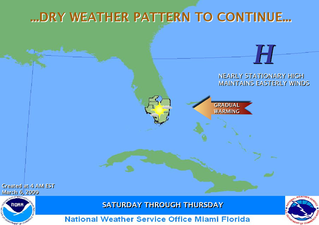
HIGH PRESSURE WILL REMAIN IN CONTROL OF THE WEATHER ACROSS THE AREA, RESULTING IN A CONTINUATION OF DRY CONDITIONS. TEMPERATURES WILL CONTINUE TO SLOWLY WARM INTO NEXT WEEK WITH HIGH'S EXPECTED TO REACH INTO THE LOWER 80S AND LOWS MAINLY IN THE 60S.
Link: http://www.srh.weather.gov/mfl/gcast/#
0 likes
-
Tampa Bay Hurricane

- Category 5
- Posts: 5597
- Age: 38
- Joined: Fri Jul 22, 2005 7:54 pm
- Location: St. Petersburg, FL
Re: Florida Weather Thread: Gradual warming & dry weather
March 7, 2009: 64/79*F
March 8, 2009: 66/80*F
At the house...
Near the driveway was closer to 85, but that was due to concrete.
March 8, 2009: 66/80*F
At the house...
Near the driveway was closer to 85, but that was due to concrete.
0 likes
-
HURAKAN
- Professional-Met
- Posts: 46084
- Age: 39
- Joined: Thu May 20, 2004 4:34 pm
- Location: Key West, FL
- Contact:
Re: Florida Weather Thread: Gradual warming & dry weather
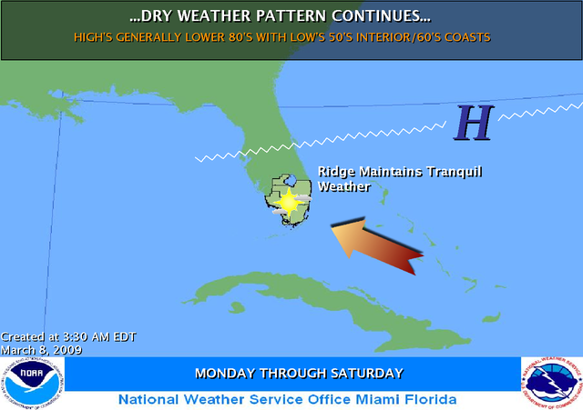
"HIGH PRESSURE WILL CONTINUE TO DOMINATE THE WEATHER THROUGHOUT THE WEEK. THIS WILL LEAD TO A CONTINUATION OF DRY CONDITIONS. TEMPERATURES WILL AVERAGE SLIGHTLY ABOVE NORMAL."
Link: http://www.srh.weather.gov/mfl/gcast/#
0 likes
Re: Florida Weather Thread: Dry weather pattern continues
Weekend saw continued expansion of extreme KBDI fire danger indices across especially the interior south peninsula.

Okeechobee Lake Elevations
07 MAR 2009 12.57 *avg for 3/7 is 14.49
1 Day = 06 MAR 2009 12.59
2 Days = 05 MAR 2009 12.61
3 Days = 04 MAR 2009 12.62
4 Days = 03 MAR 2009 12.65
7 Days = 28 FEB 2009 12.78
30 Days = 05 FEB 2009 13.21
http://www.saj.usace.army.mil/h2o/reports/r-oke.txt
Okeechobee Lake Elevations
07 MAR 2009 12.57 *avg for 3/7 is 14.49
1 Day = 06 MAR 2009 12.59
2 Days = 05 MAR 2009 12.61
3 Days = 04 MAR 2009 12.62
4 Days = 03 MAR 2009 12.65
7 Days = 28 FEB 2009 12.78
30 Days = 05 FEB 2009 13.21
http://www.saj.usace.army.mil/h2o/reports/r-oke.txt
0 likes
-
DESTRUCTION5

- Category 5
- Posts: 4430
- Age: 44
- Joined: Wed Sep 03, 2003 11:25 am
- Location: Stuart, FL
Re: Florida Weather Thread: Dry weather pattern continues
Forecast looking like 'typical march' pattern setting up....sunny, warm, and dry (unfortunately)...
NWS Forecast for: Miami FL
Issued by: National Weather Service Miami - South Florida
Last Update: 10:55 am EDT Mar 9, 2009
--------------------------------------------------------------------------------
This Afternoon: Mostly sunny, with a high near 80.
Tonight: Partly cloudy, with a low around 66.
Tuesday: Mostly sunny, with a high near 81.
Tuesday Night: Partly cloudy, with a low around 66.
Wednesday: Mostly sunny, with a high near 81.
Wednesday Night: Partly cloudy, with a low around 67.
Thursday: Mostly sunny, with a high near 81.
Thursday Night: Partly cloudy, with a low around 68.
Friday: Mostly sunny, with a high near 81.
Friday Night: Partly cloudy, with a low around 69.
Saturday: Mostly sunny, with a high near 83.
Saturday Night: Partly cloudy, with a low around 70.
Sunday: Mostly sunny, with a high near 84.
http://forecast.weather.gov/MapClick.ph ... TextType=1
0 likes
Re:
As of 3/8/09, the counties with the highest mean KBDI value are listed in order below....looks like this week could see some new members to the "700 club"
KBDI by county (mean value) as of March 8, 2009
Hendry 727
DeSoto 725
Highlands 724
Glades 722
Palm Beach 715
Martin 705
Sumter 700
Broward 695
Okeechobee 691
Miami-Dade 690
Statewide 535
http://flame.fl-dof.com/fire_weather/KB ... eport.html
By comparison, these were the KBDI values for the same counties 1 year ago (3/8/08):
Hendry 386
DeSoto 485
Highlands 430
Glades 349
Palm Beach 132
Martin 208
Sumter 106
Broward 296
Okeechobee 359
Miami-Dade 474
Statewide 170
http://flame.fl-dof.com/fire_weather/KB ... 80308.html
DESTRUCTION5 wrote::uarrow:
Ohh good Im now in the Violet Purple...
0 likes
-
Tampa Bay Hurricane
- Category 5
- Posts: 5597
- Age: 38
- Joined: Fri Jul 22, 2005 7:54 pm
- Location: St. Petersburg, FL
-
Tampa Bay Hurricane
- Category 5
- Posts: 5597
- Age: 38
- Joined: Fri Jul 22, 2005 7:54 pm
- Location: St. Petersburg, FL
-
JonathanBelles
- Professional-Met
- Posts: 11430
- Age: 35
- Joined: Sat Dec 24, 2005 9:00 pm
- Location: School: Florida State University (Tallahassee, FL) Home: St. Petersburg, Florida
- Contact:
-
JonathanBelles
- Professional-Met
- Posts: 11430
- Age: 35
- Joined: Sat Dec 24, 2005 9:00 pm
- Location: School: Florida State University (Tallahassee, FL) Home: St. Petersburg, Florida
- Contact:
I think we may be in between the periods where:
1) Winter: Cold fronts make it to, and through the state of Florida in the form of a squall line. Cold blasts semi-regularly provide large differentials in day to day and hour to hour temperature. Severe weather--Heavy frosts, high wind, large hail, tornadoes--become somewhat common in the months of meteorological winter.
2) Summer: High pressure holds a tight grip onto the State of Florida and allows no organized weather to blow through; Sea Breeze storms develop mid-afternoon. The only temperature differentials acclimatize to the distance from the shore line; cooler with the length of day closer to the coastline--warmer further from the cooler bodies of water; High 80's to low 90's much of the meteorological summer. Severe Weather--Strong storms, frequent lightning, small hail, high winds--happen on a day to day basis, often at the same hour daily depending on location and prevailing wind of the day; Hurricanes also become a higher risk late in the season.
Which unfortunately means less, to no rain chance until the temps come up to around 90.
0 likes
Re:
Yep...unfortunately the in between period we are in correlates with when the fire season in florida commences in mid-March through May....long stretches of sunny and progressively warmer days with limited humidity and rain chances....you can really see how the area around Lake O is drying up and how dry the everglades and interior peninsula are.
Note the areas over 750 in some places in interior Palm Beach, Collier, and Glades county....the highest category on the scale.
Below is the detailed KBDI map (shows variations within a county vs map that assigns an overall value to a county)

Note the areas over 750 in some places in interior Palm Beach, Collier, and Glades county....the highest category on the scale.
Below is the detailed KBDI map (shows variations within a county vs map that assigns an overall value to a county)
fact789 wrote:I think we may be in between the periods where:
1) Winter: Cold fronts make it to, and through the state of Florida in the form of a squall line. Cold blasts semi-regularly provide large differentials in day to day and hour to hour temperature. Severe weather--Heavy frosts, high wind, large hail, tornadoes--become somewhat common in the months of meteorological winter.
2) Summer: High pressure holds a tight grip onto the State of Florida and allows no organized weather to blow through; Sea Breeze storms develop mid-afternoon. The only temperature differentials acclimatize to the distance from the shore line; cooler with the length of day closer to the coastline--warmer further from the cooler bodies of water; High 80's to low 90's much of the meteorological summer. Severe Weather--Strong storms, frequent lightning, small hail, high winds--happen on a day to day basis, often at the same hour daily depending on location and prevailing wind of the day; Hurricanes also become a higher risk late in the season.
Which unfortunately means less, to no rain chance until the temps come up to around 90.
0 likes
Re: Florida Weather Thread: Dry weather pattern continues
Looks like a serious Lushine test year coming up.
0 likes
-
gatorcane

- S2K Supporter

- Posts: 23708
- Age: 48
- Joined: Sun Mar 13, 2005 3:54 pm
- Location: Boca Raton, FL
GFS at 216 hours brings a strong front through Florida ending the warm pattern we have been in...and look at all of the rain it brings with this front. Of course, its still 9 days out but that is about the next chance of measurable rain across Florida:

BTW has anybody noted how powerful this front is? In fact the trough is stronger than the big fronts of Jan and Feb...except its going to happen in the mid to late March timeframe which should keep the temps warmer than the 30s across Southern Florida. If it were back then count on another big freeze threat yet again. Will this pattern of above normal temperatures for two weeks followed by prolonged periods of extreme troughiness in the East Coast of the CONUS ever end? I can't remember a winter where the cold air with these fronts lasted so long.

BTW has anybody noted how powerful this front is? In fact the trough is stronger than the big fronts of Jan and Feb...except its going to happen in the mid to late March timeframe which should keep the temps warmer than the 30s across Southern Florida. If it were back then count on another big freeze threat yet again. Will this pattern of above normal temperatures for two weeks followed by prolonged periods of extreme troughiness in the East Coast of the CONUS ever end? I can't remember a winter where the cold air with these fronts lasted so long.
0 likes
Re: Florida Weather Thread: Dry weather pattern continues
March sun going to work statewide this pm....as of 2pm, temps in the high 70's and low 80's statewide

Surf temps starting to inch up as well...

Great day for Spring Break....webcam shot from Fort Lauderdale beach

Surf temps starting to inch up as well...
Great day for Spring Break....webcam shot from Fort Lauderdale beach
0 likes
Return to “USA & Caribbean Weather”
Who is online
Users browsing this forum: rwfromkansas, Will_TX and 66 guests