Wave WSW of CV Islands

This is the general tropical discussion area. Anyone can take their shot at predicting a storms path.

Moderator: S2k Moderators

Forum rules

The posts in this forum are NOT official forecasts and should not be used as such. They are just the opinion of the poster and may or may not be backed by sound meteorological data. They are NOT endorsed by any professional institution or STORM2K. For official information, please refer to products from the National Hurricane Center and National Weather Service.

Help Support Storm2K
Message
Author
User avatar
cycloneye
Admin
Admin
Posts: 145277
Age: 68
Joined: Thu Oct 10, 2002 10:54 am
Location: San Juan, Puerto Rico

Re: Wave about to emerge Africa=Models hint at development

#41 Postby cycloneye » Tue Jul 27, 2010 9:30 pm

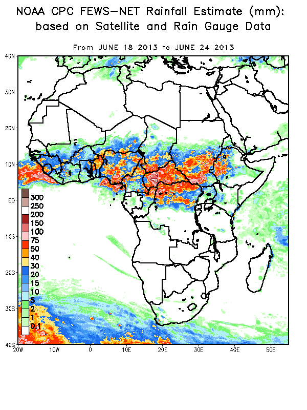
Certainly, the rainfall amounts have increased inside Africa in the past few weeks.

http://www.cpc.ncep.noaa.gov/products/african_desk/
Image
0 likes   
Visit the Caribbean-Central America Weather Thread where you can find at first post web cams,radars
and observations from Caribbean basin members Click Here

User avatar
HURAKAN
Professional-Met
Professional-Met
Posts: 46086
Age: 38
Joined: Thu May 20, 2004 4:34 pm
Location: Key West, FL
Contact:

#42 Postby HURAKAN » Tue Jul 27, 2010 11:07 pm

Image

Latest SAL
0 likes   

User avatar
HURAKAN
Professional-Met
Professional-Met
Posts: 46086
Age: 38
Joined: Thu May 20, 2004 4:34 pm
Location: Key West, FL
Contact:

#43 Postby HURAKAN » Tue Jul 27, 2010 11:22 pm

Image

We must watch the wave near 35W over the next few days
0 likes   

User avatar
HURAKAN
Professional-Met
Professional-Met
Posts: 46086
Age: 38
Joined: Thu May 20, 2004 4:34 pm
Location: Key West, FL
Contact:

#44 Postby HURAKAN » Tue Jul 27, 2010 11:27 pm

Image

Probably old but this is the latest!
0 likes   

User avatar
KWT
Category 5
Category 5
Posts: 31415
Joined: Tue Aug 17, 2004 11:02 am
Location: UK!!!

#45 Postby KWT » Wed Jul 28, 2010 4:09 am

Need to watch the African coast soon, the models are becoming really rather suggestive of something developing...
0 likes   
Personal Forecast Disclaimer:
The posts in this forum are NOT official forecast and should not be used as such. They are just the opinion of the poster and may or may not be backed by sound meteorological data. They are NOT endorsed by any professional institution or storm2k.org. For official information, please refer to the NHC and NWS products


User avatar
KWT
Category 5
Category 5
Posts: 31415
Joined: Tue Aug 17, 2004 11:02 am
Location: UK!!!

#47 Postby KWT » Wed Jul 28, 2010 5:19 am

The wave does look interesting i have to admit, though the models seem to favour the one behind it possibly...

That being said looking hard at the ECM it does seem to track something in this region and if it is a slow mover this region maybe one to watch, we'll see...almost certainly the one the CMC is tracking.
0 likes   
Personal Forecast Disclaimer:
The posts in this forum are NOT official forecast and should not be used as such. They are just the opinion of the poster and may or may not be backed by sound meteorological data. They are NOT endorsed by any professional institution or storm2k.org. For official information, please refer to the NHC and NWS products

Vortmax1
Category 1
Category 1
Posts: 360
Joined: Wed Jul 07, 2010 11:35 pm
Location: Port Salerno, FL
Contact:

#48 Postby Vortmax1 » Wed Jul 28, 2010 5:34 am

According to the 00Z models we could have at least two systems originating way out here to track in the next 10 days.
Seeing the ECM this morning was definitely interesting.


Image


TROPICAL DISCUSSION - INTERNATIONAL DESKS
NWS HYDROMETEOROLOGICAL PREDICTION CENTER CAMP SPRINGS MD
234 PM EDT TUE JUL 27 2010

AT LOW LEVELS EXPECTING A TROPICAL WAVE TO MOVE ACROSS
THE ISLAND CHAIN LATE ON WEDNESDAY AND APPROACH THE PUERTO RICO
FORECAST AREA DURING THE EARLY MORNING HOURS ON THURSDAY. THE WAVE
IS TO INTERACT WITH THE TROUGH ALOFT TO FAVOR A MOIST SURGE...WITH
PWS INCREASING ABOVE 50MM. THE OPERATIONAL GFS MADE SOME
CORRECTIONS AND IT IS NOW MORE IN TUNE WITH THE EXPERIMENTAL (SOON
TO BECOME OPERATIONAL) PARALLEL GFS...AS BOTH SHOW INCREASE IN
CONVECTIVE ACTIVITY THROUGH THURSDAY AFTERNOON. A SLIGHT LULL IN
ACTIVITY IS EXPECTED ON FRIDAY AHEAD OF THE NEXT EASTERLY WAVE
THAT ENTERS THE BASIN LATE ON SATURDAY. THE LATTER WILL TAKE
ADVANTAGE OF A DEEPER TUTT PATTERN NORTH OF THE ISLANDS AND IS
LIKELY TO BE MORE ACTIVE/BETTER ORGANIZED. BUT AS UNFAVORABLE MJO
CONDITIONS ARE FORECAST TO PERSIST INTO NEXT WEEK...SO WE ARE NOT
TOO CONFIDENT ON POSSIBILITY OF ORGANIZED/HEAVY CONVECTION.
MOST
LIKELY WE ARE GOING TO SEE VERY LOCALIZED MAXIMA WITH MODERATE
RAINFALL AMOUNTS ACROSS THE FORECAST AREA.
0 likes   

User avatar
cycloneye
Admin
Admin
Posts: 145277
Age: 68
Joined: Thu Oct 10, 2002 10:54 am
Location: San Juan, Puerto Rico

Re: Wave about to emerge Africa=Models hint at development

#49 Postby cycloneye » Wed Jul 28, 2010 5:42 am

I am in the development bandwagon after the ECMWF came aboard.

192 hours

Image

240 hours

Image
0 likes   
Visit the Caribbean-Central America Weather Thread where you can find at first post web cams,radars
and observations from Caribbean basin members Click Here

User avatar
wxman57
Moderator-Pro Met
Moderator-Pro Met
Posts: 22977
Age: 67
Joined: Sat Jun 21, 2003 8:06 pm
Location: Houston, TX (southwest)

Re: Wave about to emerge Africa=Models hint at development

#50 Postby wxman57 » Wed Jul 28, 2010 5:47 am

The models aren't developing any current wave, they're developing a feature that's still over central Africa. I think that we may well have another 5-10 days before the next storm forms (2nd week of August). That's when the next upward motion pulse reaches the Atlantic Basin.
0 likes   

User avatar
cycloneye
Admin
Admin
Posts: 145277
Age: 68
Joined: Thu Oct 10, 2002 10:54 am
Location: San Juan, Puerto Rico

Re: Wave about to emerge Africa=Models hint at development

#51 Postby cycloneye » Wed Jul 28, 2010 5:49 am

wxman57 wrote:The models aren't developing any current wave, they're developing a feature that's still over central Africa. I think that we may well have another 5-10 days before the next storm forms (2nd week of August). That's when the next upward motion pulse reaches the Atlantic Basin.


That is why I mantain the title (Wave about to emerge Africa)
0 likes   
Visit the Caribbean-Central America Weather Thread where you can find at first post web cams,radars
and observations from Caribbean basin members Click Here

rockyman
Category 5
Category 5
Posts: 1967
Joined: Thu Jun 26, 2003 12:24 pm
Location: Dauphin Island, AL

#52 Postby rockyman » Wed Jul 28, 2010 6:00 am

According to this loop, the low that becomes the storm in the Caribbean will be south of the Cape Verdes by Friday evening:

http://raleighwx.easternuswx.com/models ... _loop.html
0 likes   

Vortmax1
Category 1
Category 1
Posts: 360
Joined: Wed Jul 07, 2010 11:35 pm
Location: Port Salerno, FL
Contact:

#53 Postby Vortmax1 » Wed Jul 28, 2010 6:02 am

The area seems to be in the crosshairs of interest now:


Image


Image
0 likes   

User avatar
cycloneye
Admin
Admin
Posts: 145277
Age: 68
Joined: Thu Oct 10, 2002 10:54 am
Location: San Juan, Puerto Rico

Re: Wave about to emerge Africa=Models hint at development

#54 Postby cycloneye » Wed Jul 28, 2010 6:25 am

Nice visible image loop.

Image
0 likes   
Visit the Caribbean-Central America Weather Thread where you can find at first post web cams,radars
and observations from Caribbean basin members Click Here

User avatar
ronjon
Category 5
Category 5
Posts: 4822
Joined: Fri Aug 19, 2005 5:17 pm
Location: Hernando Beach, FL

Re:

#55 Postby ronjon » Wed Jul 28, 2010 6:40 am

rockyman wrote:According to this loop, the low that becomes the storm in the Caribbean will be south of the Cape Verdes by Friday evening:

http://raleighwx.easternuswx.com/models ... _loop.html


So the Euro is clearly developing the wave emerging off the African coast this morning and not the one due south of the Cape Verde Islands now.
0 likes   

User avatar
Blown Away
S2K Supporter
S2K Supporter
Posts: 10145
Joined: Wed May 26, 2004 6:17 am

Re: Re:

#56 Postby Blown Away » Wed Jul 28, 2010 7:24 am

ronjon wrote:
rockyman wrote:According to this loop, the low that becomes the storm in the Caribbean will be south of the Cape Verdes by Friday evening:

http://raleighwx.easternuswx.com/models ... _loop.html


So the Euro is clearly developing the wave emerging off the African coast this morning and not the one due south of the Cape Verde Islands now.


I agree, it does appear the wave coming off Africa today is the wave that develops and if the ECMWF is correct the high pressure is building in as this system moves through the NE Caribbean in about 10 days.
0 likes   
Hurricane Eye Experience: David 79, Irene 99, Frances 04, Jeanne 04, Wilma 05... EYE COMING MY WAY IN 2024…
Hurricane Brush Experience: Andrew 92, Erin 95, Floyd 99, Matthew 16, Irma 17, Ian 22, Nicole 22…

User avatar
cycloneye
Admin
Admin
Posts: 145277
Age: 68
Joined: Thu Oct 10, 2002 10:54 am
Location: San Juan, Puerto Rico

Re: Wave about to emerge Africa=Models hint at development

#57 Postby cycloneye » Wed Jul 28, 2010 7:29 am

Below is the mention of the possible? developing area? or is still inside Africa? There is some confusion about which area is the one the models are latching on. Or maybe two different systems? As you can see many questions are pending on this.

SCATTERED MODERATE/ISOLATED STRONG CONVECTION IS OFF THE COAST
OF AFRICA FROM 7N-12N BETWEEN 13W-21W. NUMEROUS STRONG
CONVECTION IS FROM 8N-11N BETWEEN 22W-25W
.
0 likes   
Visit the Caribbean-Central America Weather Thread where you can find at first post web cams,radars
and observations from Caribbean basin members Click Here

User avatar
TheBurn
Category 2
Category 2
Posts: 540
Joined: Thu Jul 28, 2005 4:00 pm
Location: Rincon, PR

Re: Wave about to emerge Africa=Models hint at development

#58 Postby TheBurn » Wed Jul 28, 2010 7:40 am

Image
0 likes   

hurricaneCW
Category 5
Category 5
Posts: 1794
Joined: Wed Mar 03, 2010 6:20 am
Location: Toms River, NJ

Re: Wave about to emerge Africa=Models hint at development

#59 Postby hurricaneCW » Wed Jul 28, 2010 8:24 am

wxman57 wrote:The models aren't developing any current wave, they're developing a feature that's still over central Africa. I think that we may well have another 5-10 days before the next storm forms (2nd week of August). That's when the next upward motion pulse reaches the Atlantic Basin.


I agree that it will take almost two weeks for anything to get going. Looks like another surge of SAL with the wave coming off the African coastline and wind shear isn't too favorable either for parts of the eastern Atlantic and Caribbean. The 2nd half of August should be quite active if the models are correct.
0 likes   

User avatar
Riptide
Category 2
Category 2
Posts: 753
Age: 33
Joined: Fri Jul 23, 2010 3:33 pm
Location: Cape May, New Jersey
Contact:

Re: Wave about to emerge Africa=Models hint at development

#60 Postby Riptide » Wed Jul 28, 2010 8:41 am

hurricaneCW wrote:
wxman57 wrote:The models aren't developing any current wave, they're developing a feature that's still over central Africa. I think that we may well have another 5-10 days before the next storm forms (2nd week of August). That's when the next upward motion pulse reaches the Atlantic Basin.


I agree that it will take almost two weeks for anything to get going. Looks like another surge of SAL with the wave coming off the African coastline and wind shear isn't too favorable either for parts of the eastern Atlantic and Caribbean. The 2nd half of August should be quite active if the models are correct.

According to nearly every model, including the euro. We should already have Colin by August at least August 10th, GFS says August 2nd-4th. More to come! Just look at the amount of moisture that is now in the MDR(Not much but it is not a desert anymore) and the new wave train that is just plowing through. The wave that just exited Africa already has a strong surface vorticity associated with it.

In response to your SAL assessment, Parts of Northern Africa have been receiving record rainfall and if you combine this with an active wave train, SAL will quickly become a non-factor and already has in many ways especially with waves that enter the Atlantic at a very low latitude.
0 likes   


Return to “Talkin' Tropics”

Who is online

Users browsing this forum: JaviT, LarryWx and 27 guests