
ATL: LORENZO - Post-Tropical
Moderator: S2k Moderators
-
SouthDadeFish

- Professional-Met

- Posts: 2836
- Joined: Thu Sep 23, 2010 2:54 pm
- Location: Miami, FL
- Contact:
-
wxman57

- Moderator-Pro Met

- Posts: 23175
- Age: 68
- Joined: Sat Jun 21, 2003 8:06 pm
- Location: Houston, TX (southwest)
Re: ATL: LORENZO - Tropical Storm
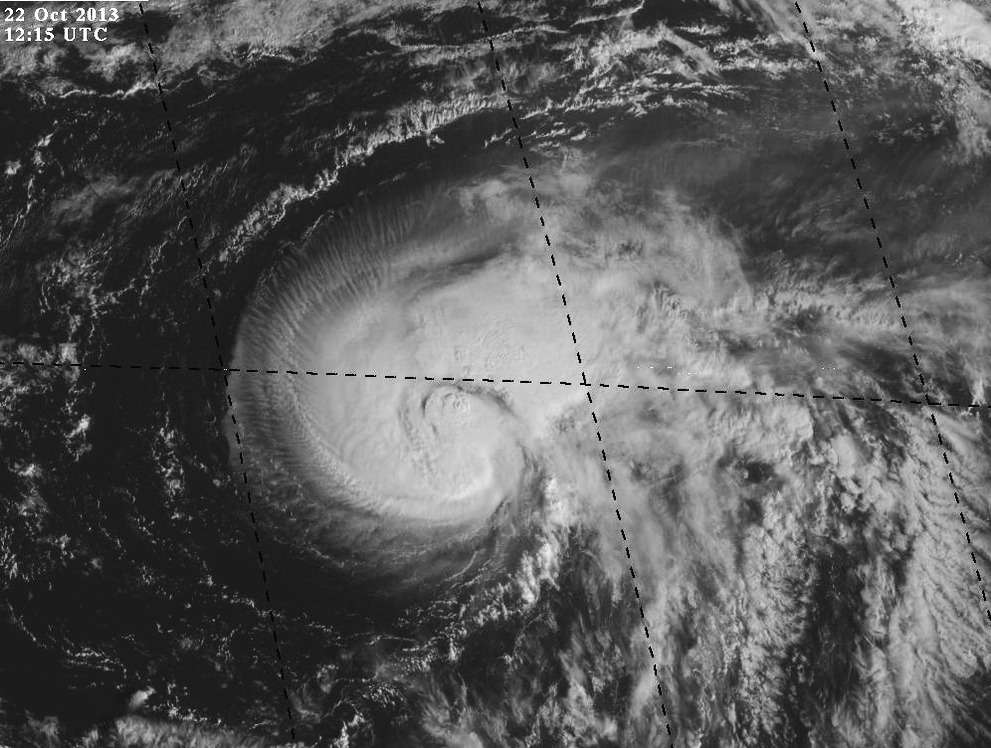
Microwave imagery indicates an eye is forming. Probably around 55kts now. Could be a hurricane today.
0 likes
-
tolakram
- Admin

- Posts: 20186
- Age: 62
- Joined: Sun Aug 27, 2006 8:23 pm
- Location: Florence, KY (name is Mark)
Re: ATL: LORENZO - Tropical Storm
hurricanes1234 wrote:Sorry guys, but I see no strengthening here.
NOT OFFICIAL!
This is in a prime location and the perfect time of year for a sneaky hurricane shooting NE with the upper level flow.
0 likes
M a r k
- - - - -
Join us in chat: Storm2K Chatroom Invite. Android and IOS apps also available.
The posts in this forum are NOT official forecasts and should not be used as such. Posts are NOT endorsed by any professional institution or STORM2K.org. For official information and forecasts, please refer to NHC and NWS products.
-
tolakram
- Admin
- Posts: 20186
- Age: 62
- Joined: Sun Aug 27, 2006 8:23 pm
- Location: Florence, KY (name is Mark)
Re: ATL: LORENZO - Tropical Storm
1 likes
M a r k
- - - - -
Join us in chat: Storm2K Chatroom Invite. Android and IOS apps also available.
The posts in this forum are NOT official forecasts and should not be used as such. Posts are NOT endorsed by any professional institution or STORM2K.org. For official information and forecasts, please refer to NHC and NWS products.
- - - - -
Join us in chat: Storm2K Chatroom Invite. Android and IOS apps also available.
The posts in this forum are NOT official forecasts and should not be used as such. Posts are NOT endorsed by any professional institution or STORM2K.org. For official information and forecasts, please refer to NHC and NWS products.


NHC has this only hitting 40 kts? Looks much better today, wonder if they will up that forecast for the next 12-24 hrs.
0 likes
Andrew '92 Opal '95 Blizzard '96 Izzy '03 Irene '11 Sandy '12
The following post is NOT an official forecast and should not be used as such. It is just the opinion is not be backed by sound meteorological data. It is NOT endorsed by any professional institution including storm2k.org For Official Information please refer to the NHC and NWS products.
The following post is NOT an official forecast and should not be used as such. It is just the opinion is not be backed by sound meteorological data. It is NOT endorsed by any professional institution including storm2k.org For Official Information please refer to the NHC and NWS products.

Re:
Bizzles wrote:NHC has this only hitting 40 kts? Looks much better today, wonder if they will up that forecast for the next 12-24 hrs.
yeah it's probably well beyond that already, it looks like it has to be 50kts at least based on appearance and organization.
0 likes
The above post is not official and should not be used as such. It is the opinion of the poster and may or may not be backed by sound meteorological data. It is not endorsed by any professional institution or storm2k.org. For official information, please refer to the NHC and NWS products.
-
HurricaneBelle

- S2K Supporter

- Posts: 1209
- Joined: Sun Aug 27, 2006 6:12 pm
- Location: Clearwater, FL
-
CrazyC83
- Professional-Met
- Posts: 34316
- Joined: Tue Mar 07, 2006 11:57 pm
- Location: Deep South, for the first time!
Re:
HurricaneBelle wrote:NHC really lowballed it in their last advisory at 45 kt (I'm sure it had nothing to do with the fact they didn't call for it to intensify much) There's also been a further blowup of convection near the center in the last hour or two.
What is the latest Dvorak on this?
Last one was T3.5. At least blending them out would support 50 kt, although I tend to agree with the 3.5 and would have gone with 55 kt.
0 likes
-
Hurricane_Luis

- Category 2

- Posts: 723
- Age: 27
- Joined: Sat Jun 23, 2012 3:14 pm
- Location: Tiptree, Essex, United Kingdom
- Contact:
Re: ATL: LORENZO - Tropical Storm
HurricaneBelle wrote:
What is the latest Dvorak on this?
UW - CIMSS
ADVANCED DVORAK TECHNIQUE
ADT-Version 8.1.5
Tropical Cyclone Intensity Algorithm
----- Current Analysis -----
Date : 22 OCT 2013 Time : 151500 UTC
Lat : 29:30:21 N Lon : 51:57:55 W
CI# /Pressure/ Vmax
3.1 / 997.8mb/ 47.0kt
Final T# Adj T# Raw T#
3.1 3.3 3.8
Center Temp : -61.9C Cloud Region Temp : -63.3C
Scene Type : UNIFORM CDO CLOUD REGION
http://tropic.ssec.wisc.edu/real-time/adt/odt13L.html
0 likes
Given the satellite appearance earlier, how possible is it that it either is or was at/near hurricane intensity?
0 likes
The above post is not official and should not be used as such. It is the opinion of the poster and may or may not be backed by sound meteorological data. It is not endorsed by any professional institution or storm2k.org. For official information, please refer to the NHC and NWS products.
-
cycloneye

- Admin
- Posts: 149686
- Age: 69
- Joined: Thu Oct 10, 2002 10:54 am
- Location: San Juan, Puerto Rico
Re: ATL: LORENZO - Tropical Storm
18z Best Track stays at 45kts.
AL, 13, 2013102218, , BEST, 0, 292N, 516W, 45, 1003, TS, 34, NEQ, 60, 60, 0, 0, 1014, 200, 40, 0, 0, L, 0, , 0, 0, LORENZO, M
AL, 13, 2013102218, , BEST, 0, 292N, 516W, 45, 1003, TS, 34, NEQ, 60, 60, 0, 0, 1014, 200, 40, 0, 0, L, 0, , 0, 0, LORENZO, M
0 likes
Visit the Caribbean-Central America Weather Thread where you can find at first post web cams,radars
and observations from Caribbean basin members Click Here
and observations from Caribbean basin members Click Here
-
hurricanes1234
- Category 5

- Posts: 2908
- Joined: Sat Jul 28, 2012 6:19 pm
- Location: Trinidad and Tobago
Re: ATL: LORENZO - Tropical Storm
Looks like it's getting sheared again? Has that violent outflow characteristic of strong shear.

0 likes
PLEASE NOTE: With the exception of information from weather agencies that I may copy and paste here, my posts will NEVER be official, since I am NOT a meteorologist. They are solely my amateur opinion, and may or may not be accurate. Therefore, please DO NOT use them as official details, particularly when making important decisions. Thank you.
-
wxman57
- Moderator-Pro Met
- Posts: 23175
- Age: 68
- Joined: Sat Jun 21, 2003 8:06 pm
- Location: Houston, TX (southwest)
Re: ATL: LORENZO - Tropical Storm
Yes, probably peaked at 50-55 kts earlier this morning. Wind shear is increasing again.
0 likes
-
hurricanes1234
- Category 5
- Posts: 2908
- Joined: Sat Jul 28, 2012 6:19 pm
- Location: Trinidad and Tobago
Re: ATL: LORENZO - Tropical Storm
wxman57 wrote:Yes, probably peaked at 50-55 kts earlier this morning. Wind shear is increasing again.
Can't imagine what the shear map looks like up there in a year like 2013, numbers are probably over 30 and 40 knots on a regular day.
0 likes
PLEASE NOTE: With the exception of information from weather agencies that I may copy and paste here, my posts will NEVER be official, since I am NOT a meteorologist. They are solely my amateur opinion, and may or may not be accurate. Therefore, please DO NOT use them as official details, particularly when making important decisions. Thank you.
-
ozonepete
- Professional-Met
- Posts: 4743
- Joined: Mon Sep 07, 2009 3:23 pm
- Location: From Ozone Park, NYC / Now in Brooklyn, NY
Re: ATL: LORENZO - Tropical Storm
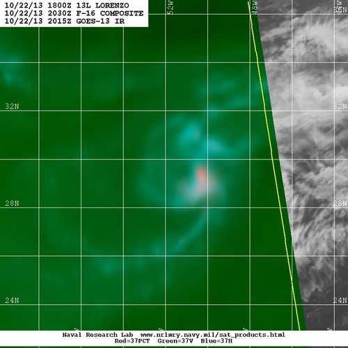
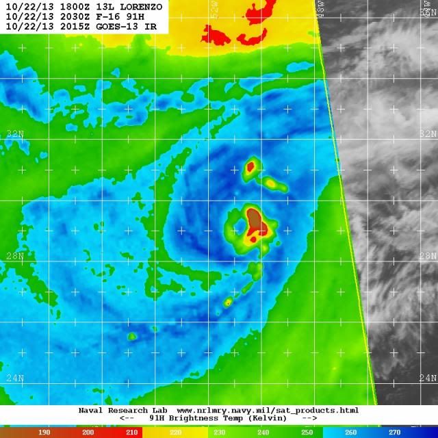
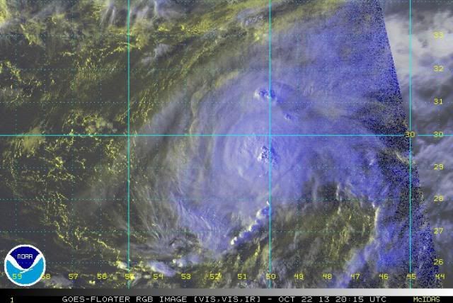
Was definitely 5-55 knots earlier today. Also, the 5PM discussion was a little weird saying "THE CONVECTIVE STRUCTURE HAS BECOME MORE ASYMMETRIC...WITH MOST OF THE DEEP CONVECTION DISPLACED EAST OF CIRCULATION CENTER DUE TO GRADUALLY INCREASING WEST-NORTHWESTERLY VERTICAL WIND SHEAR." The change in symmetry was not major, and the microwave satellites I'm posting here from 4:30PM EDT this afternoon show the storm is quite well stacked with the deep convection right over both of the clearly visible centers on the 37GHz and 91GHz microwaves. The 91GHz center (shows mid level center better) is just slightly east of the 37GHz center (which shows low level center better). It almost seems that they were describing what they expected tomorrow night rather than what was going on. Very odd. I also posted the corresponding 4:15PM EDT rgb satellite where it's clear the center of deep convection was right over the microwave centers. That was a very odd discussion.
37GHz
91GHz
RGB satellite:
37GHz

91GHz

RGB satellite:

Last edited by ozonepete on Tue Oct 22, 2013 6:26 pm, edited 1 time in total.
0 likes
Who is online
Users browsing this forum: No registered users and 127 guests