

From Dr Jeff Masters Blog this morning:
Keeping an eye on the Gulf of Mexico
In the Gulf of Mexico, a weak cold front is kicking up some heavy thunderstorms in the Louisiana coastal waters. This activity will spread to the Texas coastal waters by Wednesday. With wind shear a moderate 10 - 20 knots, we should monitor this area for development. About 1/3 of the 20 members of the 06Z Monday GFS model ensemble showed some development in the Gulf on Thursday or Friday. (The GFS ensemble is a set of 20 runs of the GFS model done at lower resolution with slightly different initial conditions to generate an uncertainty "plume" of model runs.) The preferred track of the system was to the west towards Texas.
possibility of GOM action later in week? (is INVEST 98L)
Moderator: S2k Moderators
Forum rules

The posts in this forum are NOT official forecasts and should not be used as such. They are just the opinion of the poster and may or may not be backed by sound meteorological data. They are NOT endorsed by any professional institution or STORM2K. For official information, please refer to products from the National Hurricane Center and National Weather Service.


Re: possibility of GOM action later in week?
I wonder how much lead time there was during or right before Hurricane Alicia.
0 likes
Re:
Alyono wrote:models often do not give much lead time on these kids of systems
Alyono when I look at the models here http://ruc.noaa.gov/hfip/tcgen/ it shows a green dot coming what appears from the YUC channel maybe?but the moisture envelope is N of the dot(s) if I am reading it right?Am I off base.
I am looking at the UKMET.
0 likes
Re: possibility of GOM action later in week?
Does anyone anticipate this becoming an invest or is/has it already?
0 likes
-
South Texas Storms

- Professional-Met

- Posts: 4246
- Joined: Thu Jun 24, 2010 12:28 am
- Location: Houston, TX
Re: possibility of GOM action later in week?
Senobia wrote:Does anyone anticipate this becoming an invest or is/has it already?
It's not currently an invest, but it could become one soon.
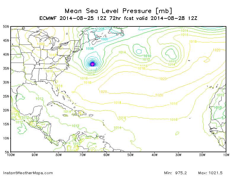
The 12z UKMET shows a 1007 mb low just east of Brownsville in 96 hours.
0 likes
-
srainhoutx

- S2K Supporter

- Posts: 6919
- Age: 68
- Joined: Sun Jan 14, 2007 11:34 am
- Location: Haywood County, NC
- Contact:
Re: possibility of GOM action later in week?
MODEL DIAGNOSTIC DISCUSSION
NWS WEATHER PREDICTION CENTER COLLEGE PARK MD
1224 PM EDT MON AUG 25 2014
VALID AUG 25/1200 UTC THRU AUG 29/0000 UTC
...SEE NOUS42 KWNO (ADMNFD) FOR THE STATUS OF THE UPPER AIR
INGEST...
12Z NAM/GFS EVALUATION WITH PRELIMINARY MODEL PREFERENCES
~~~~~~~~~~~~~~~~~~~~~~~~~~~~~~~~~~~~~~~~~~~~~~~~~~~~~~~~~
NAM/GFS INITIALIZATION ERRORS DO NOT SEEM TO DEGRADE THEIR SHORT
RANGE FORECASTS.
WEAK CYCLONE MOVING THROUGH THE GULF OF MEXICO
~~~~~~~~~~~~~~~~~~~~~~~~~~~~~~~~~~~~~~~~~~~~~~
PREFERENCE: UKMET/ECMWF COMPROMISE
CONFIDENCE: ABOVE AVERAGE
MOST OF THE GUIDANCE TRACKS A WEAK LOW OFF THE TAIL END OF A
FRONTAL BOUNDARY ACROSS THE GULF OF MEXICO TO THE EAST SIDE OF A
WEAK UPPER LEVEL LOW, WITH THE 00Z CANADIAN PRODUCING TWO FOR THE
PRICE OF ONE -- ITS USUAL SPECIAL WITH POSSIBLE
TROPICAL/CONVECTIVE LOWS. SINCE THE NATIONAL HURRICANE CENTER IS
NOT DISCUSSING THIS SYSTEM, PREFER TO DOWNPLAY ITS PREFERENCE. A
COMPROMISE OF THE 00Z UKMET/00Z ECMWF IS PREFERRED HERE WITH ABOVE
AVERAGE CONFIDENCE CONSIDERING CANADIAN/NAM STRENGTH BIASES ALOFT.
0 likes
Carla/Alicia/Jerry(In The Eye)/Michelle/Charley/Ivan/Dennis/Katrina/Rita/Wilma/Ike/Harvey
Member: National Weather Association
Wx Infinity Forums
http://wxinfinity.com/index.php
Facebook.com/WeatherInfinity
Twitter @WeatherInfinity
Member: National Weather Association
Wx Infinity Forums
http://wxinfinity.com/index.php
Facebook.com/WeatherInfinity
Twitter @WeatherInfinity
-
tolakram
- Admin

- Posts: 20168
- Age: 62
- Joined: Sun Aug 27, 2006 8:23 pm
- Location: Florence, KY (name is Mark)
Re: possibility of GOM action later in week?
30 frame live visible
http://wwwghcc.msfc.nasa.gov/cgi-bin/get-goes?satellite=GOES-E%20CONUS&lat=27&lon=-89&info=vis&zoom=1&width=1000&height=800&quality=95&type=Animation&palette=ir1.pal&numframes=30
http://wwwghcc.msfc.nasa.gov/cgi-bin/get-goes?satellite=GOES-E%20CONUS&lat=27&lon=-89&info=vis&zoom=1&width=1000&height=800&quality=95&type=Animation&palette=ir1.pal&numframes=30
0 likes
M a r k
- - - - -
Join us in chat: Storm2K Chatroom Invite. Android and IOS apps also available.
The posts in this forum are NOT official forecasts and should not be used as such. Posts are NOT endorsed by any professional institution or STORM2K.org. For official information and forecasts, please refer to NHC and NWS products.


-
tolakram
- Admin
- Posts: 20168
- Age: 62
- Joined: Sun Aug 27, 2006 8:23 pm
- Location: Florence, KY (name is Mark)
Re: possibility of GOM action later in week?
12Z Euro might be hinting at something just south of the TX border.
0 likes
M a r k
- - - - -
Join us in chat: Storm2K Chatroom Invite. Android and IOS apps also available.
The posts in this forum are NOT official forecasts and should not be used as such. Posts are NOT endorsed by any professional institution or STORM2K.org. For official information and forecasts, please refer to NHC and NWS products.
- - - - -
Join us in chat: Storm2K Chatroom Invite. Android and IOS apps also available.
The posts in this forum are NOT official forecasts and should not be used as such. Posts are NOT endorsed by any professional institution or STORM2K.org. For official information and forecasts, please refer to NHC and NWS products.
-
tolakram
- Admin
- Posts: 20168
- Age: 62
- Joined: Sun Aug 27, 2006 8:23 pm
- Location: Florence, KY (name is Mark)
Re: possibility of GOM action later in week?
Here is the Euro vorticity from the tropical EWALL site.

http://mp1.met.psu.edu/~fxg1/ECMWFTROPATL0.5_12z/ecmwfloop.html
http://mp1.met.psu.edu/~fxg1/ECMWFTROPATL0.5_12z/ecmwfloop.html
0 likes
M a r k
- - - - -
Join us in chat: Storm2K Chatroom Invite. Android and IOS apps also available.
The posts in this forum are NOT official forecasts and should not be used as such. Posts are NOT endorsed by any professional institution or STORM2K.org. For official information and forecasts, please refer to NHC and NWS products.
- - - - -
Join us in chat: Storm2K Chatroom Invite. Android and IOS apps also available.
The posts in this forum are NOT official forecasts and should not be used as such. Posts are NOT endorsed by any professional institution or STORM2K.org. For official information and forecasts, please refer to NHC and NWS products.
-
stormlover2013
Re: possibility of GOM action later in week?
shouldn't it say on the 24 hr tues instead of monday?
0 likes

Re: possibility of GOM action later in week?
tolakram wrote:Here is the Euro vorticity from the tropical EWALL site.
http://mp1.met.psu.edu/~fxg1/ECMWFTROPATL0.5_12z/ecmwfloop.html
This is yesterday's run.
0 likes
-
tolakram
- Admin
- Posts: 20168
- Age: 62
- Joined: Sun Aug 27, 2006 8:23 pm
- Location: Florence, KY (name is Mark)
Re: possibility of GOM action later in week?
Hrmph,
well it should update at that link once the run is done.
well it should update at that link once the run is done.
0 likes
M a r k
- - - - -
Join us in chat: Storm2K Chatroom Invite. Android and IOS apps also available.
The posts in this forum are NOT official forecasts and should not be used as such. Posts are NOT endorsed by any professional institution or STORM2K.org. For official information and forecasts, please refer to NHC and NWS products.
- - - - -
Join us in chat: Storm2K Chatroom Invite. Android and IOS apps also available.
The posts in this forum are NOT official forecasts and should not be used as such. Posts are NOT endorsed by any professional institution or STORM2K.org. For official information and forecasts, please refer to NHC and NWS products.


Re: possibility of GOM action later in week?
Vorticity has really increased in the gulf today albeit elongated, but nonetheless it's increasing
NOW

3 HOURS AGO:

NOW
3 HOURS AGO:
Last edited by baytownwx on Mon Aug 25, 2014 2:09 pm, edited 1 time in total.
0 likes
The following post is NOT an official forecast and should not be used as such. It is just the opinion of the poster and may or may not be backed by sound meteorological data. It is NOT endorsed by storm2k.org.
-
stormlover2013
Re: possibility of GOM action later in week?
http://mp1.met.psu.edu/~fxg1/ECMWFTROPA ... floop.html
euro has something cooking next tues by corpus
euro has something cooking next tues by corpus
Last edited by stormlover2013 on Mon Aug 25, 2014 2:09 pm, edited 1 time in total.
0 likes
-
tolakram
- Admin
- Posts: 20168
- Age: 62
- Joined: Sun Aug 27, 2006 8:23 pm
- Location: Florence, KY (name is Mark)
Re: possibility of GOM action later in week?
Here we go, apparently I had to clear my cache of old images.


0 likes
M a r k
- - - - -
Join us in chat: Storm2K Chatroom Invite. Android and IOS apps also available.
The posts in this forum are NOT official forecasts and should not be used as such. Posts are NOT endorsed by any professional institution or STORM2K.org. For official information and forecasts, please refer to NHC and NWS products.
- - - - -
Join us in chat: Storm2K Chatroom Invite. Android and IOS apps also available.
The posts in this forum are NOT official forecasts and should not be used as such. Posts are NOT endorsed by any professional institution or STORM2K.org. For official information and forecasts, please refer to NHC and NWS products.
Who is online
Users browsing this forum: No registered users and 44 guests