SIO: HORACIO - Post-Tropical
Moderator: S2k Moderators


Re: SIO: HORACIO - Tropical Cyclone
Horacio has now intensified by 50 kt in 24 hours, according to the JTWC's operational Best Track. A very impressive performance so far, and it may still have a little while to keep going - their new forecast peak is 115 kt by 18z today.
0 likes
-
cycloneye

- Admin

- Posts: 149667
- Age: 69
- Joined: Thu Oct 10, 2002 10:54 am
- Location: San Juan, Puerto Rico
Re: SIO: HORACIO - Tropical Cyclone
Tropical Cyclone Horacio
Estimated maximum wind speeds (averaged over 10 minutes) at sea: 140 km/h.
Estimated maximum gusts at sea: 195 km/h.
Estimated pressure at the center: 969 hPa.
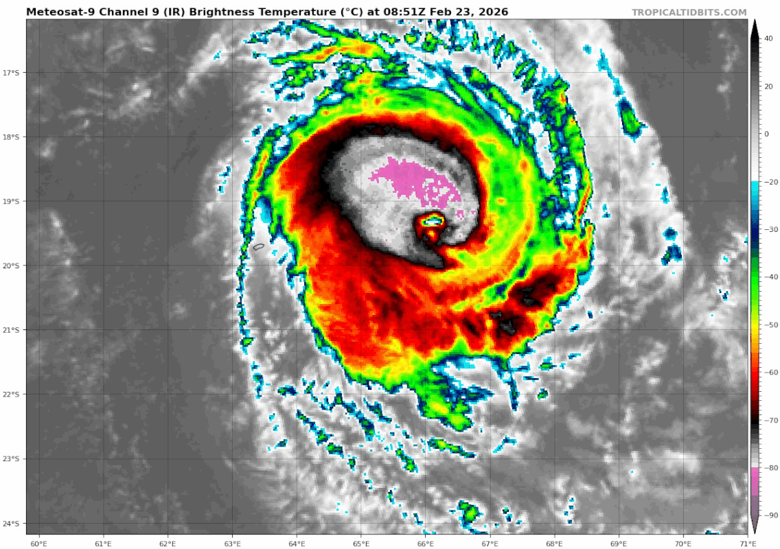
Position on February 23 at 10 a.m. local time: 19.0 South / 66.6 East.
Distance from the coast of Réunion: 1150 km to the East sector
Distance from Mayotte: 2390 km to the East-Southeast sector
Movement: SOUTHWEST, at 17 km/h.
System information:
- Tropical cyclone HORACIO is moving across the center of the basin. It is currently located about 300 km east of Rodrigues.
- The system is expected to continue moving southwest before curving its trajectory southward on Tuesday.
- Continuing its intensification phase, it could reach the stage of an intense tropical cyclone late Monday before weakening in the following days.
- HORACIO, with a fairly compact structure, should pass a little over 200km east of Rodrigues at the end of the day on Monday before moving away.
Estimated maximum wind speeds (averaged over 10 minutes) at sea: 140 km/h.
Estimated maximum gusts at sea: 195 km/h.
Estimated pressure at the center: 969 hPa.
Position on February 23 at 10 a.m. local time: 19.0 South / 66.6 East.
Distance from the coast of Réunion: 1150 km to the East sector
Distance from Mayotte: 2390 km to the East-Southeast sector
Movement: SOUTHWEST, at 17 km/h.
System information:
- Tropical cyclone HORACIO is moving across the center of the basin. It is currently located about 300 km east of Rodrigues.
- The system is expected to continue moving southwest before curving its trajectory southward on Tuesday.
- Continuing its intensification phase, it could reach the stage of an intense tropical cyclone late Monday before weakening in the following days.
- HORACIO, with a fairly compact structure, should pass a little over 200km east of Rodrigues at the end of the day on Monday before moving away.
0 likes
Visit the Caribbean-Central America Weather Thread where you can find at first post web cams,radars
and observations from Caribbean basin members Click Here
and observations from Caribbean basin members Click Here
-
cycloneye
- Admin
- Posts: 149667
- Age: 69
- Joined: Thu Oct 10, 2002 10:54 am
- Location: San Juan, Puerto Rico
Re: SIO: HORACIO - Intense Tropical Cyclone
It has gone boom in the past 12 hours.

3 likes
Visit the Caribbean-Central America Weather Thread where you can find at first post web cams,radars
and observations from Caribbean basin members Click Here
and observations from Caribbean basin members Click Here
-
cycloneye
- Admin
- Posts: 149667
- Age: 69
- Joined: Thu Oct 10, 2002 10:54 am
- Location: San Juan, Puerto Rico
Re: SIO: HORACIO - Intense Tropical Cyclone
Up to Intense.
INTENSE TROPICAL CYCLONE HORACIO
Estimated maximum wind speeds (averaged over 10 minutes) at sea: 185 km/h.
Estimated maximum gusts at sea: 260 km/h.
Estimated pressure at the center: 946 hPa.
Position on February 23 at 4 p.m. local time: 19.8 South / 65.7 East.
Distance from the coast of Réunion: 1040 km to the East sector
Distance from Mayotte: 2320 km to the East-Southeast sector
Movement: SOUTHWEST, at 22 km/h.
1 likes
Visit the Caribbean-Central America Weather Thread where you can find at first post web cams,radars
and observations from Caribbean basin members Click Here
and observations from Caribbean basin members Click Here
Re: SIO: HORACIO - Intense Tropical Cyclone
Horacio's current intensity seems comparable to Cyclone Dudzai at its peak, based on satellite imagery. We have a T6.0 fix from JTWC (based on VIS), T6.5 from UW-CIMSS ADT, and a subjective Dvorak fix based on EIR imagery would support T6.5 or 7.0, depending on which frame you're looking at (WMG eye surrounded by W or B, plus 1.0 adjustment for CMG). A simple blend of those estimates supports 125 kt / 928 hPa.
0 likes
-
Yellow Evan

- Professional-Met

- Posts: 16256
- Age: 27
- Joined: Fri Jul 15, 2011 12:48 pm
- Location: Henderson, Nevada/Honolulu, HI
- Contact:
Re: SIO: HORACIO - Intense Tropical Cyclone
Probably around 125 knots now yes. The SIO does it again.
1 likes

Re: SIO: HORACIO - Intense Tropical Cyclone
2 likes
TC naming lists: retirements and intensity
Most aggressive Advisory #1's in North Atlantic (cr. kevin for starting the list)
Most aggressive Advisory #1's in North Atlantic (cr. kevin for starting the list)
Re: SIO: HORACIO - Intense Tropical Cyclone
A. TROPICAL CYCLONE 22S (HORACIO)
B. 23/1431Z
C. 20.08S
D. 65.46E
E. ONE/MET9
F. T7.0/7.0/D3.0/24HRS STT: D0.5/03HRS
G. IR/EIR
H. REMARKS: 01A/PBO EYE/ANMTN. WMG EYE SURROUNDED BY W YIELDS AN E#
OF 6.0. ADDED 1.0 EYE ADJUSTMENT FOR CMG, TO YIELD A DT OF 7.0. MET
YIELDS 5.5. PT YIELDS 6.0. DBO DT. BROKE CONSTRAINTS DUE TO RAPID
INTENSIFICATION. REANALYZED PREVIOUS FIX FOR INTENSITY.
CI 7.0 from JTWC (and Adj. T 7.0 / FT 6.7 from ADT). We might be close to our first SSHWS Category 5 of 2026 (though it's unlikely to be reflected in the operational BT, with the 12z point having been only 110 kt.)
1 likes
-
cycloneye
- Admin
- Posts: 149667
- Age: 69
- Joined: Thu Oct 10, 2002 10:54 am
- Location: San Juan, Puerto Rico
Re: SIO: HORACIO - Intense Tropical Cyclone
1 likes
Visit the Caribbean-Central America Weather Thread where you can find at first post web cams,radars
and observations from Caribbean basin members Click Here
and observations from Caribbean basin members Click Here
Re: SIO: HORACIO - Intense Tropical Cyclone
F. T7.0/7.0/D3.0/24HRS STT: S0.0/03HRS
G. IR/EIR
H. REMARKS: 01A/PBO EYE/ANMTN. WMG EYE (+19C) SURROUNDED BY W
YIELDS AN E# OF 6.0. ADDED 1.0 EYE ADJUSTMENT FOR CMG, TO YIELD A
DT OF 7.0. MET YIELDS 5.5. PT YIELDS 6.0. DBO DT.
G. IR/EIR
H. REMARKS: 01A/PBO EYE/ANMTN. WMG EYE (+19C) SURROUNDED BY W
YIELDS AN E# OF 6.0. ADDED 1.0 EYE ADJUSTMENT FOR CMG, TO YIELD A
DT OF 7.0. MET YIELDS 5.5. PT YIELDS 6.0. DBO DT.
(emphasis added)
Don't think Horacio has much longer at peak intensity, but what a show - and thankfully, far from populated areas.
Edit: 18z BT point adjusted to 140 kt, 920 hPa. Horacio is officially the first (JTWC-assessed) Category 5 cyclone of 2026.
1 likes
-
cycloneye
- Admin
- Posts: 149667
- Age: 69
- Joined: Thu Oct 10, 2002 10:54 am
- Location: San Juan, Puerto Rico
Re: SIO: HORACIO - Intense Tropical Cyclone
-------------------------------------------------
INTENSE TROPICAL CYCLONE HORACIO
Estimated maximum wind speeds (averaged over 10 minutes) at sea: 215 km/h.
Estimated maximum gusts at sea: 295 km/h.
Estimated pressure at the center: 933 hPa.
Position on February 23 at 10 p.m. local time: 20.6 South / 65.1 East.
Distance from the coast of Réunion: 965 km to the East sector
Distance from Mayotte: 2300 km to the East-Southeast sector
Movement: SOUTH-SOUTHWEST, at 20 km/h.
1 likes
Visit the Caribbean-Central America Weather Thread where you can find at first post web cams,radars
and observations from Caribbean basin members Click Here
and observations from Caribbean basin members Click Here
-
cycloneye
- Admin
- Posts: 149667
- Age: 69
- Joined: Thu Oct 10, 2002 10:54 am
- Location: San Juan, Puerto Rico
Re: SIO: HORACIO - Intense Tropical Cyclone
It peaked as cat 5 at 18:00 UTC and now is downhill from here going to extratropical.
INTENSE TROPICAL CYCLONE HORACIO
Estimated maximum wind speeds (averaged over 10 minutes) at sea: 215 km/h.
Estimated maximum gusts at sea: 295 km/h.
Estimated pressure at the center: 935 hPa.
Position on February 24 at 04:00 local time: 21.5 South / 64.5 East.
Distance from the coast of Réunion: 900 km to the East
Distance from Mayotte: 2270 km to the East-Southeast sector
Movement: SOUTH-SOUTHWEST, at 19 km/h.
System information:
- HORACIO appears to have reached its peak intensity last night at the upper end of the intense tropical cyclone stage. It is a particularly intense cyclone for such a southern latitude (around 21°S)
0 likes
Visit the Caribbean-Central America Weather Thread where you can find at first post web cams,radars
and observations from Caribbean basin members Click Here
and observations from Caribbean basin members Click Here
-
MarioProtVI
- Category 5

- Posts: 1038
- Age: 24
- Joined: Sun Sep 29, 2019 7:33 pm
- Location: New Jersey
Re: SIO: HORACIO - Intense Tropical Cyclone
Of course I miss a Cat 5 in the SWIO (the first since 2023, pending Chido’s reanalysis) because of me suffering a historic blizzard here in New Jersey 

3 likes
-
cycloneye
- Admin
- Posts: 149667
- Age: 69
- Joined: Thu Oct 10, 2002 10:54 am
- Location: San Juan, Puerto Rico
Re: SIO: HORACIO - Intense Tropical Cyclone
Beautiful image when it was at peak intensity.

1 likes
Visit the Caribbean-Central America Weather Thread where you can find at first post web cams,radars
and observations from Caribbean basin members Click Here
and observations from Caribbean basin members Click Here
-
Hurricane2022

- Category 5
- Posts: 2084
- Joined: Tue Aug 23, 2022 11:38 pm
- Location: Araçatuba, Brazil
Re: SIO: HORACIO - Intense Tropical Cyclone
1 likes
Sorry for the bad English sometimes...!
For reliable and detailed information for any meteorological phenomenon, please consult the National Hurricane Center, Joint Typhoon Warning Center , or your local Meteo Center.
--------
ECCE OMNIA NOVA FACIAM (Ap 21,5).
For reliable and detailed information for any meteorological phenomenon, please consult the National Hurricane Center, Joint Typhoon Warning Center , or your local Meteo Center.
--------
ECCE OMNIA NOVA FACIAM (Ap 21,5).
-
cycloneye
- Admin
- Posts: 149667
- Age: 69
- Joined: Thu Oct 10, 2002 10:54 am
- Location: San Juan, Puerto Rico
Re: SIO: HORACIO - Intense Tropical Cyclone
INTENSE TROPICAL CYCLONE HORACIO
Estimated maximum wind speeds (averaged over 10 minutes) at sea: 175 km/h.
Estimated maximum gusts at sea: 250 km/h.
Estimated pressure at the center: 954 hPa.
Position on February 24 at 10 a.m. local time: 22.5 South / 64.2 East.
Distance from the coast of Réunion: 880 km to the East-Southeast sector
Distance from Mayotte: 2290 km to the East-Southeast sector
Movement: SOUTH-SOUTHWEST, at 19 km/h.
System information:
- After reaching its peak intensity last night, HORACIO has begun to weaken. It is still temporarily an intense tropical cyclone and is moving south-southwest, away from Rodrigues.
- This Tuesday, HORACIO should gradually curve its trajectory towards the south and then towards the south-southeast, continuing to weaken considerably.
0 likes
Visit the Caribbean-Central America Weather Thread where you can find at first post web cams,radars
and observations from Caribbean basin members Click Here
and observations from Caribbean basin members Click Here
-
cycloneye
- Admin
- Posts: 149667
- Age: 69
- Joined: Thu Oct 10, 2002 10:54 am
- Location: San Juan, Puerto Rico
Re: SIO: HORACIO - Tropical Cyclone
Tropical Cyclone Horacio
Estimated maximum wind speeds (averaged over 10 minutes) at sea: 155 km/h.
Estimated maximum gusts at sea: 220 km/h.
Estimated pressure at the center: 962 hPa.
Position on February 24 at 4 p.m. local time: 23.7 South / 64.4 East.
Distance from the coast of Réunion: 920 km to the East-Southeast sector
Distance from Mayotte: 2360 km to the SOUTH-EAST sector
Movement: SOUTH, at 22 km/h.
0 likes
Visit the Caribbean-Central America Weather Thread where you can find at first post web cams,radars
and observations from Caribbean basin members Click Here
and observations from Caribbean basin members Click Here
-
cycloneye
- Admin
- Posts: 149667
- Age: 69
- Joined: Thu Oct 10, 2002 10:54 am
- Location: San Juan, Puerto Rico
Re: SIO: HORACIO - Tropical Cyclone
Tropical Cyclone Horacio
Estimated maximum wind speeds (averaged over 10 minutes) at sea: 150 km/h.
Estimated maximum gusts at sea: 215 km/h.
Estimated pressure at the center: 964 hPa.
Position on February 24 at 10 p.m. local time: 25.0 South / 64.8 East.
Distance from the coast of Réunion: 1000 km to the East-Southeast sector
Distance from Mayotte: 2460 km to the SOUTH-EAST sector
Movement: SOUTH-SOUTH-EAST, at 30 km/h.
0 likes
Visit the Caribbean-Central America Weather Thread where you can find at first post web cams,radars
and observations from Caribbean basin members Click Here
and observations from Caribbean basin members Click Here
-
cycloneye
- Admin
- Posts: 149667
- Age: 69
- Joined: Thu Oct 10, 2002 10:54 am
- Location: San Juan, Puerto Rico
Re: SIO: HORACIO - Tropical Cyclone
It was a spectacular fotogenic cyclone when it was at the peak.
https://x.com/CIRA_CSU/status/2026438039321338015
https://x.com/CIRA_CSU/status/2026438039321338015
1 likes
Visit the Caribbean-Central America Weather Thread where you can find at first post web cams,radars
and observations from Caribbean basin members Click Here
and observations from Caribbean basin members Click Here
-
cycloneye
- Admin
- Posts: 149667
- Age: 69
- Joined: Thu Oct 10, 2002 10:54 am
- Location: San Juan, Puerto Rico
Re: SIO: HORACIO - Tropical Cyclone
Tropical Cyclone Horacio
Estimated maximum wind speeds (averaged over 10 minutes) at sea: 140 km/h.
Estimated maximum gusts at sea: 195 km/h.
Estimated pressure at the center: 968 hPa.
Position on February 25 at 04:00 local time: 26.4 South / 65.3 East.
Distance from the coast of Réunion: 1120 km to the East-Southeast sector
Distance from Mayotte: 2590 km to the SOUTH-EAST sector
Movement: SOUTH-SOUTH-EAST, at 28 km/h.
0 likes
Visit the Caribbean-Central America Weather Thread where you can find at first post web cams,radars
and observations from Caribbean basin members Click Here
and observations from Caribbean basin members Click Here
Who is online
Users browsing this forum: No registered users and 39 guests