HC Emily may be a repeat of HC Gilbert of 88'

This is the general tropical discussion area. Anyone can take their shot at predicting a storms path.

Moderator: S2k Moderators

Forum rules

The posts in this forum are NOT official forecasts and should not be used as such. They are just the opinion of the poster and may or may not be backed by sound meteorological data. They are NOT endorsed by any professional institution or STORM2K. For official information, please refer to products from the National Hurricane Center and National Weather Service.

Help Support Storm2K
Message
Author
User avatar
HollynLA
S2K Supporter
S2K Supporter
Posts: 836
Joined: Sat Aug 28, 2004 10:36 pm
Location: South Louisiana

#41 Postby HollynLA » Thu Jul 14, 2005 12:16 pm

Why anyone would go to an off-shore island to report on a land-falling category 5 hurricane is beyond my capacity to understand.


I can understand it. Once in a lifetime opportunity to see.
0 likes   

User avatar
CaptinCrunch
S2K Supporter
S2K Supporter
Posts: 8740
Age: 57
Joined: Mon Nov 03, 2003 4:33 pm
Location: Kennedale, TX (Tarrant Co.)

#42 Postby CaptinCrunch » Thu Jul 14, 2005 12:28 pm

EDR1222 wrote:
mobilebay wrote:
Hurricaneman wrote:Hopefully this is nowhere near as strong as Gilbert, probably wont be

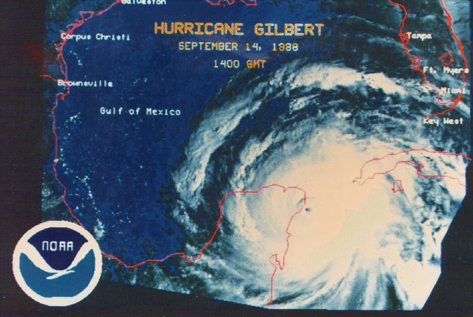
Odds are 1 to 1.000,000 in won't be. Remember Gilbert was the strongest hurricane ever recorded in the Atalntic Basin. Lowest pressure


I agree. It is highly unlikely it gets anywhere near that strength, IMHO.


THE HURRICANE WILL BE MOVING OVER WATERS OF
INCREASINGLY HIGH OCEANIC HEAT CONTENT FOR THE NEXT COUPLE OF DAYS.
THUS...ADDITIONAL STRENGTHENING SEEMS LIKELY. THE NHC INTENSITY
FORECAST IS A BLEND OF THE GFDL AND SHIPS GUIDANCE...AND CALLS FOR
SOMEWHAT MORE STRENGTHENING THAN THE PREVIOUS FORECAST.


As Emily moves out away from Venezuela and heads more over the open waters of the Caribbean her wind field should increase as well, she may not get as big as what Gilbert was but she sure has the chance to be as strong.

Emily reach C2 earlier than Gilbert did and the Caribbean waters are a few degrees warmer now than what they are in mid-September when Gilbert formed.
0 likes   

User avatar
CaptinCrunch
S2K Supporter
S2K Supporter
Posts: 8740
Age: 57
Joined: Mon Nov 03, 2003 4:33 pm
Location: Kennedale, TX (Tarrant Co.)

#43 Postby CaptinCrunch » Thu Jul 14, 2005 12:51 pm

HURRICANE EMILY INTERMEDIATE ADVISORY NUMBER 15A
NWS TPC/NATIONAL HURRICANE CENTER MIAMI FL
2 PM AST THU JUL 14 2005


...EMILY CONTINUES TO STRENGTHEN...NEARLY CATEGORY THREE...

REPEATING THE 2 PM AST POSITION...12.9 N... 65.0 W. MOVEMENT
TOWARD...WEST-NORTHWEST NEAR 18 MPH. MAXIMUM SUSTAINED
WINDS...110 MPH. MINIMUM CENTRAL PRESSURE... 972 MB.
0 likes   

User avatar
CaptinCrunch
S2K Supporter
S2K Supporter
Posts: 8740
Age: 57
Joined: Mon Nov 03, 2003 4:33 pm
Location: Kennedale, TX (Tarrant Co.)

#44 Postby CaptinCrunch » Thu Jul 14, 2005 4:28 pm

BULLETIN
HURRICANE EMILY ADVISORY NUMBER 16
NWS TPC/NATIONAL HURRICANE CENTER MIAMI FL
5 PM AST THU JUL 14 2005


...EMILY BECOMES A DANGEROUS CATEGORY THREE HURRICANE...


MAXIMUM SUSTAINED WINDS CONTINUE TO INCREASE AND ARE NOW NEAR 115
MPH...185 KM/HR...WITH HIGHER GUSTS. EMILY IS A CATEGORY THREE
HURRICANE ON THE SAFFIR-SIMPSON SCALE...THE SECOND MAJOR HURRICANE
OF THE SEASON. SOME ADDITIONAL STRENGTHENING IS FORECAST DURING
THE NEXT 24 HOURS.

REPEATING THE 5 PM AST POSITION...13.3 N... 65.9 W. MOVEMENT
TOWARD...WEST-NORTHWEST NEAR 21 MPH. MAXIMUM SUSTAINED
WINDS...115 MPH. MINIMUM CENTRAL PRESSURE... 968 MB.
0 likes   

User avatar
CalmBeforeStorm
Category 2
Category 2
Posts: 600
Age: 72
Joined: Tue Aug 10, 2004 7:55 pm
Location: Stuart, Florida

#45 Postby CalmBeforeStorm » Thu Jul 14, 2005 4:35 pm

http://www.nhc.noaa.gov/gifs/1988gilbert.gif

~~~~~~~~~~~~~~~~
Gilbert was much bigger in overall size.
0 likes   

User avatar
CaptinCrunch
S2K Supporter
S2K Supporter
Posts: 8740
Age: 57
Joined: Mon Nov 03, 2003 4:33 pm
Location: Kennedale, TX (Tarrant Co.)

#46 Postby CaptinCrunch » Thu Jul 14, 2005 4:39 pm

CalmBeforeStorm wrote:http://www.nhc.noaa.gov/gifs/1988gilbert.gif

~~~~~~~~~~~~~~~~
Gilbert was much bigger in overall size.


Let's compare that pic to Emily after the next 72hrs when she is at the Yucatun.
0 likes   

clfenwi
Category 5
Category 5
Posts: 3331
Joined: Thu Jun 09, 2005 12:54 pm

#47 Postby clfenwi » Thu Jul 14, 2005 4:48 pm

IF the shear west of 80° West (1) clears, then stand by to stand by; it could really be off to the races as far as intensity goes.

With not only warmer water (2), but warm water extending deeper(3) than Dennis enjoyed off of Florida, the potential exists for her to beat him out.

That of course, hinges on the big if of shear decreasing as expected. As Derek has noted several times, shear forecasts aren't exactly the most reliable product out there.

For anyone and everyone suggesting that SSTs are warmer than they were for Gilbert: Links, please. What I have been able to piece together indicate that the SSTs are comparable. While the SST anomaly is high (water is warmer than normal for this time of season), everything I have seen indicates that the overall SSTs are about the same.


(1) http://cimss.ssec.wisc.edu/tropic/real- ... g8shr.html
(2) http://polar.ncep.noaa.gov/sst/natl_sst_oper0.gif
(3) http://www.aoml.noaa.gov/phod/dataphod1 ... 193d26.png
0 likes   

User avatar
CaptinCrunch
S2K Supporter
S2K Supporter
Posts: 8740
Age: 57
Joined: Mon Nov 03, 2003 4:33 pm
Location: Kennedale, TX (Tarrant Co.)

#48 Postby CaptinCrunch » Thu Jul 14, 2005 4:49 pm

Image
0 likes   

User avatar
CalmBeforeStorm
Category 2
Category 2
Posts: 600
Age: 72
Joined: Tue Aug 10, 2004 7:55 pm
Location: Stuart, Florida

#49 Postby CalmBeforeStorm » Thu Jul 14, 2005 4:49 pm

CaptinCrunch wrote:
CalmBeforeStorm wrote:http://www.nhc.noaa.gov/gifs/1988gilbert.gif

~~~~~~~~~~~~~~~~
Gilbert was much bigger in overall size.


Let's compare that pic to Emily after the next 72hrs when she is at the Yucatun.

~~~~~~~~~~~~~~~~~~
Don't assume that even a category 5 Emily will become larger in overall size. Even cat 5 hurricanes come in different size packages.
0 likes   

Scorpion

#50 Postby Scorpion » Thu Jul 14, 2005 4:51 pm

Wow I wish I went on a cruise now. Imagine just staring down a Cat 5 from the deck.
0 likes   

User avatar
gtalum
S2K Supporter
S2K Supporter
Posts: 4749
Age: 49
Joined: Tue Sep 07, 2004 3:48 pm
Location: Bradenton, FL
Contact:

#51 Postby gtalum » Thu Jul 14, 2005 4:51 pm

Scorpion wrote:Wow I wish I went on a cruise now. Imagine just staring down a Cat 5 from the deck.


Cruise ships tend to stay away from Hurricanes.
0 likes   

Scorpion

#52 Postby Scorpion » Thu Jul 14, 2005 4:52 pm

Yes I know but still you probably would be in the outer bands.
0 likes   

Brent
S2K Supporter
S2K Supporter
Posts: 38266
Age: 37
Joined: Sun May 16, 2004 10:30 pm
Location: Tulsa Oklahoma
Contact:

#53 Postby Brent » Thu Jul 14, 2005 4:57 pm

Scorpion wrote:Wow I wish I went on a cruise now. Imagine just staring down a Cat 5 from the deck.


Uh... that would never happen unless it was totally unexpected.
0 likes   
#neversummer

User avatar
stormie_skies
Category 5
Category 5
Posts: 3318
Joined: Tue Aug 12, 2003 9:25 pm
Location: League City, TX

#54 Postby stormie_skies » Thu Jul 14, 2005 4:57 pm

Scorpion wrote:Ok, this scenario will not happen. Its July folks! And also, we just had a major hurricane! Dennis! Emily will not, can not do the same!


Welcome to the 2005 season, buddy! :eek: :lol:
0 likes   


Return to “Talkin' Tropics”

Who is online

Users browsing this forum: Google Adsense [Bot] and 210 guests