WTPN31 PGTW 262100
MSGID/GENADMIN/NAVMARFCSTCEN PEARL HARBOR HI/JTWC//
SUBJ/TROPICAL CYCLONE WARNING//
RMKS/
1. TYPHOON 14W (NANMADOL) WARNING NR 017
02 ACTIVE TROPICAL CYCLONES IN NORTHWESTPAC
MAX SUSTAINED WINDS BASED ON ONE-MINUTE AVERAGE
WIND RADII VALID OVER OPEN WATER ONLY
---
WARNING POSITION:
261800Z --- NEAR 18.0N 122.7E
MOVEMENT PAST SIX HOURS - 305 DEGREES AT 07 KTS
POSITION ACCURATE TO WITHIN 025 NM
POSITION BASED ON EYE FIXED BY SATELLITE
PRESENT WIND DISTRIBUTION:
MAX SUSTAINED WINDS - 120 KT, GUSTS 145 KT
WIND RADII VALID OVER OPEN WATER ONLY
RADIUS OF 064 KT WINDS - 050 NM NORTHEAST QUADRANT
050 NM SOUTHEAST QUADRANT
050 NM SOUTHWEST QUADRANT
050 NM NORTHWEST QUADRANT
RADIUS OF 050 KT WINDS - 080 NM NORTHEAST QUADRANT
080 NM SOUTHEAST QUADRANT
080 NM SOUTHWEST QUADRANT
080 NM NORTHWEST QUADRANT
RADIUS OF 034 KT WINDS - 120 NM NORTHEAST QUADRANT
120 NM SOUTHEAST QUADRANT
100 NM SOUTHWEST QUADRANT
120 NM NORTHWEST QUADRANT
REPEAT POSIT: 18.0N 122.7E
---
FORECASTS:
12 HRS, VALID AT:
270600Z --- 18.9N 122.1E
MAX SUSTAINED WINDS - 125 KT, GUSTS 150 KT
WIND RADII VALID OVER OPEN WATER ONLY
RADIUS OF 064 KT WINDS - 045 NM NORTHEAST QUADRANT
045 NM SOUTHEAST QUADRANT
045 NM SOUTHWEST QUADRANT
045 NM NORTHWEST QUADRANT
RADIUS OF 050 KT WINDS - 080 NM NORTHEAST QUADRANT
080 NM SOUTHEAST QUADRANT
080 NM SOUTHWEST QUADRANT
080 NM NORTHWEST QUADRANT
RADIUS OF 034 KT WINDS - 125 NM NORTHEAST QUADRANT
125 NM SOUTHEAST QUADRANT
110 NM SOUTHWEST QUADRANT
125 NM NORTHWEST QUADRANT
VECTOR TO 24 HR POSIT: 335 DEG/ 06 KTS
---
24 HRS, VALID AT:
271800Z --- 19.9N 121.6E
MAX SUSTAINED WINDS - 120 KT, GUSTS 145 KT
WIND RADII VALID OVER OPEN WATER ONLY
RADIUS OF 064 KT WINDS - 045 NM NORTHEAST QUADRANT
045 NM SOUTHEAST QUADRANT
045 NM SOUTHWEST QUADRANT
045 NM NORTHWEST QUADRANT
RADIUS OF 050 KT WINDS - 075 NM NORTHEAST QUADRANT
075 NM SOUTHEAST QUADRANT
075 NM SOUTHWEST QUADRANT
075 NM NORTHWEST QUADRANT
RADIUS OF 034 KT WINDS - 130 NM NORTHEAST QUADRANT
130 NM SOUTHEAST QUADRANT
115 NM SOUTHWEST QUADRANT
125 NM NORTHWEST QUADRANT
VECTOR TO 36 HR POSIT: 350 DEG/ 05 KTS
---
36 HRS, VALID AT:
280600Z --- 20.8N 121.4E
MAX SUSTAINED WINDS - 115 KT, GUSTS 140 KT
WIND RADII VALID OVER OPEN WATER ONLY
RADIUS OF 064 KT WINDS - 045 NM NORTHEAST QUADRANT
045 NM SOUTHEAST QUADRANT
045 NM SOUTHWEST QUADRANT
045 NM NORTHWEST QUADRANT
RADIUS OF 050 KT WINDS - 075 NM NORTHEAST QUADRANT
075 NM SOUTHEAST QUADRANT
075 NM SOUTHWEST QUADRANT
075 NM NORTHWEST QUADRANT
RADIUS OF 034 KT WINDS - 135 NM NORTHEAST QUADRANT
130 NM SOUTHEAST QUADRANT
120 NM SOUTHWEST QUADRANT
130 NM NORTHWEST QUADRANT
VECTOR TO 48 HR POSIT: 360 DEG/ 07 KTS
---
EXTENDED OUTLOOK:
48 HRS, VALID AT:
281800Z --- 22.1N 121.4E
MAX SUSTAINED WINDS - 110 KT, GUSTS 135 KT
WIND RADII VALID OVER OPEN WATER ONLY
RADIUS OF 064 KT WINDS - 045 NM NORTHEAST QUADRANT
045 NM SOUTHEAST QUADRANT
045 NM SOUTHWEST QUADRANT
045 NM NORTHWEST QUADRANT
RADIUS OF 050 KT WINDS - 075 NM NORTHEAST QUADRANT
075 NM SOUTHEAST QUADRANT
070 NM SOUTHWEST QUADRANT
050 NM NORTHWEST QUADRANT
RADIUS OF 034 KT WINDS - 135 NM NORTHEAST QUADRANT
135 NM SOUTHEAST QUADRANT
100 NM SOUTHWEST QUADRANT
095 NM NORTHWEST QUADRANT
VECTOR TO 72 HR POSIT: 005 DEG/ 03 KTS
---
72 HRS, VALID AT:
291800Z --- 23.2N 121.5E
MAX SUSTAINED WINDS - 090 KT, GUSTS 110 KT
WIND RADII VALID OVER OPEN WATER ONLY
RADIUS OF 064 KT WINDS - 035 NM NORTHEAST QUADRANT
035 NM SOUTHEAST QUADRANT
035 NM SOUTHWEST QUADRANT
035 NM NORTHWEST QUADRANT
RADIUS OF 050 KT WINDS - 065 NM NORTHEAST QUADRANT
065 NM SOUTHEAST QUADRANT
050 NM SOUTHWEST QUADRANT
050 NM NORTHWEST QUADRANT
RADIUS OF 034 KT WINDS - 135 NM NORTHEAST QUADRANT
135 NM SOUTHEAST QUADRANT
080 NM SOUTHWEST QUADRANT
080 NM NORTHWEST QUADRANT
VECTOR TO 96 HR POSIT: 015 DEG/ 03 KTS
---
LONG RANGE OUTLOOK:
---
96 HRS, VALID AT:
301800Z --- 24.2N 121.8E
MAX SUSTAINED WINDS - 080 KT, GUSTS 100 KT
WIND RADII VALID OVER OPEN WATER ONLY
VECTOR TO 120 HR POSIT: 030 DEG/ 03 KTS
---
120 HRS, VALID AT:
311800Z --- 25.1N 122.4E
MAX SUSTAINED WINDS - 065 KT, GUSTS 080 KT
WIND RADII VALID OVER OPEN WATER ONLY
---
REMARKS:
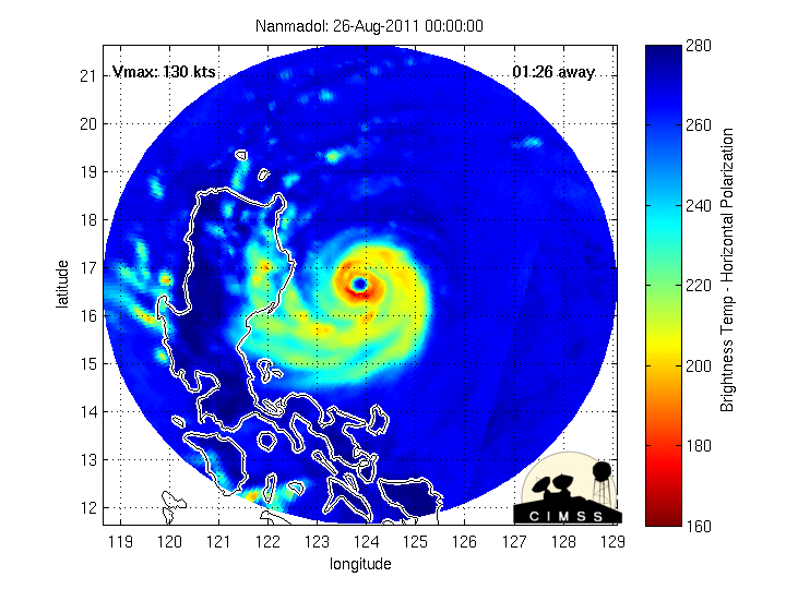
262100Z POSITION NEAR 18.2N 122.6E.
TYPHOON (TY) 14W (NANMADOL), LOCATED APPROXIMATELY 300 NM WEST-
SOUTHWEST OF KADENA AB, OKINAWA, HAS TRACKED NORTHWESTWARD AT 07
KNOTS OVER THE PAST SIX HOURS. ANIMATED INFRARED SATELLITE IMAGERY
SHOWS THAT ALTHOUGH LAND INTERACTION WITH LUZON IS ERODING THE
WESTERN SEMICIRCLE OF THE SYSTEM, THE SYSTEM MAINTAINS A 17 NM EYE
WITH NO INDICATIONS OF FILLING. A 261755Z AMSRE IMAGE REVEALS THAT
TY 14W MAINTAINS A THICK, CONCENTRIC EYEWALL. AGENCY DVORAK
INTENSITY ASSESSMENTS ALSO REMAIN HIGH. ANIMATED WATER VAPOR IMAGERY
SHOWS DUAL OUTFLOW CHANNELS, WITH THE POLEWARD CHANNEL VENTING INTO
A TUTT CELL NORTHEAST OF TAIWAN. TY 14W IS BEING NUDGED POLEWARD BY
WEAK ANTICYCLONE EMBEDDED IN THE NEAR EQUATORIAL RIDGE. THE
ANTICYCLONE EXISTS AT THE WESTERN END OF THE RIDGE. TY 14W HAS
PEAKED IN INTENSITY AND WILL BEGIN AN OVERALL DOWNTREND. IN THE
SHORT TERM, HOWEVER, THE HIGHLY FAVORABLE OUTFLOW CONDITIONS WILL
ALLOW FOR SOME MILD RE-INTENSIFICATION AS THE SYSTEM CLEARS LUZON.
BY TAU 48, IMPEDIMENTS DUE TO LAND INTERACTION WITH TAIWAN AND A
POSSIBLE EYEWALL REPLACEMENT CYCLE WILL BRING ABOUT A STEADY
WEAKENING TREND. IN THE MID TO LONG RANGE, THE NEAR EQUATORIAL RIDGE
IS EXPECTED TO BUILD AND THRUST OVER THE SOUTHERN RYUKUS, KEEPING
THE SYSTEM ON A POLEWARD TRACK. THE JTWC TRACK FORECAST IS CLOSE TO
CONSENSUS AND THE JGSM MODEL. MAXIMUM SIGNIFICANT WAVE HEIGHT AT
261800Z IS 34 FEET. NEXT WARNINGS AT 270300Z, 270900Z, 271500Z AND
272100Z. REFER TO TROPICAL STORM 15W (TALAS) WARNINGS (WTPN32 PGTW)
FOR SIX-HOURLY UPDATES.//
NNNN