


2026 ENSO Updates
Moderator: S2k Moderators
Forum rules

The posts in this forum are NOT official forecasts and should not be used as such. They are just the opinion of the poster and may or may not be backed by sound meteorological data. They are NOT endorsed by any professional institution or STORM2K. For official information, please refer to products from the National Hurricane Center and National Weather Service.
Re: 2026 ENSO Updates
MJO forecasts is looping back to the Pacific, and may loop back yet again. 200mb CHI charts show sinking motion returning to the MC region while re-igniting over the Pacific. Pretty good indicator background low frequency is shifting closer to El Nino mode.
2 likes
The above post and any post by Ntxw is NOT an official forecast and should not be used as such. It is just the opinion of the poster and may or may not be backed by sound meteorological data. It is NOT endorsed by any professional institution including Storm2k. For official information, please refer to NWS products.
Help support Storm2K!
-
AJC3

- Admin

- Posts: 4156
- Age: 62
- Joined: Tue Aug 31, 2004 7:04 pm
- Location: Ballston Spa, New York
- Contact:
Re: 2026 ENSO Updates: Breaking News=BoM announces La Niña has ended
mixedDanilo.E wrote:cycloneye wrote:The first shoe has dropped and is from the BoM of Australia.
https://i.imgur.com/SNR3rQQ.jpeg
https://www.bom.gov.au/climate/ocean/outlooks/archive/20260328//plumes/sstOutlooks.rnino34.hr.png
https://www.bom.gov.au/climate/enso/?ni ... s=Overview
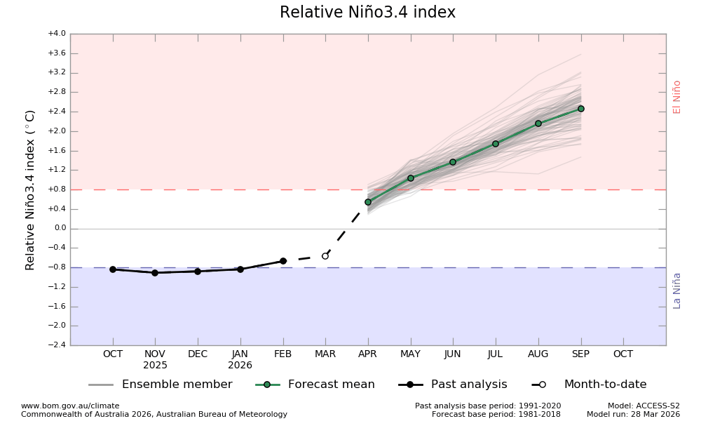
I'm not gonna lie to you, even though strong El Nino is looking more likely, I have a hard time believing we will get as as strong as the BoM forecasts, especially by September. What especially makes me want to partially throw this run out is a HUGE jump in the index from March to April. I'm sorry but I do not see that happening.
Since there's a dash between FEB-MAR, that makes me think that their MAR value (about -0.55C) is a hindcast/nowcast that was used to initialize that run of the ACCESS-S2, rather than an actual analyzed data point. That point on the graph doesn't even match their own NINO 3.4 value (-0.42C) shown in the text, and moreover, CPC's latest update from 30 MAR had that value as -0.3C. I know BoM/CPC have different ENSO thresholds, but is there also a fundamental difference in how actual ENSO values are calculated? In any event, if you plot the CPC value on the chart, then the BOM model change from MAR-APR doesn't look nearly as odd. Just some food for thought.

Caveat: There might be something I'm not taking into account about how the indices are calculated.
1 likes
-
DorkyMcDorkface

- Category 5

- Posts: 1016
- Age: 28
- Joined: Mon Sep 30, 2019 1:32 pm
- Location: Mid-Atlantic
Re: 2026 ENSO Updates
I've learned a lot about ENSO over the past 5 years but I have a question: when was the last time we've had a strong Niño event so suddenly after another? Seems like they occur once every decade or so, but this time around we're getting two in rather quick succession. I also wonder because the last time it was understandable with a triple-dip moderate Niña event the first half of the 2020s but this time around we've had two weaker Niña events (according to RONI, ONI was nearly merely cool-neutral for 2024-25). What's the case this time around?
0 likes
Please note the thoughts expressed by this account are solely those of the user and are from a hobbyist perspective. For more comprehensive analysis, consult an actual professional meteorologist or meteorological agency.
Floyd 1999 | Isabel 2003 | Hanna 2008 | Irene 2011 | Sandy 2012 | Isaias 2020
Re: 2026 ENSO Updates
DorkyMcDorkface wrote:I've learned a lot about ENSO over the past 5 years but I have a question: when was the last time we've had a strong Niño event so suddenly after another? Seems like they occur once every decade or so, but this time around we're getting two in rather quick succession. I also wonder because the last time it was understandable with a triple-dip moderate Niña event the first half of the 2020s but this time around we've had two weaker Niña events (according to RONI, ONI was nearly merely cool-neutral for 2024-25). What's the case this time around?
One aspect we have to think about is that the warm pool over the western Pacific has been prolific in the 2020s. The warm water expanse has been incredible El Nino or La Nina. 2023-2024 did not fully disperse this warm pool. It's physics, if the bathwater is continuously hot, any shift will allow it to move despite what ENSO was. This is something we don't fully understand with global oceans warming rapidly. A theoretical idea one could ask, since 2023-24 did not fully behave like a traditional Nino, could it be reason why we're seeing a more traditional one form so close?
1963-64, and then 1965-66 had a moderate and strong Nino pretty quickly.
2 likes
The above post and any post by Ntxw is NOT an official forecast and should not be used as such. It is just the opinion of the poster and may or may not be backed by sound meteorological data. It is NOT endorsed by any professional institution including Storm2k. For official information, please refer to NWS products.
Help support Storm2K!
Help support Storm2K!
-
cycloneye

- Admin
- Posts: 149505
- Age: 69
- Joined: Thu Oct 10, 2002 10:54 am
- Location: San Juan, Puerto Rico
Re: 2026 ENSO Updates
1 likes
Visit the Caribbean-Central America Weather Thread where you can find at first post web cams,radars
and observations from Caribbean basin members Click Here
and observations from Caribbean basin members Click Here
Who is online
Users browsing this forum: No registered users and 326 guests