Tropical Depression TEN: Discussions & Images
Moderator: S2k Moderators
-
miamicanes177
- Category 5

- Posts: 1131
- Joined: Tue Aug 01, 2006 10:53 pm
Re: INVEST 93L: East of South Florida: Discussion & Images
I could not imagine NHC ever upgrading a system that looked like this without having recon evidence. Anything is possible but they generally like to use caution when upgrading invests and that means having irrefutable evidence indicating it is a tropical depression or storm.
0 likes

Re: INVEST 93L: Discussion & Images=5:30 PM TWO at page 18
CrazyC83 wrote:miamicanes177 wrote:I'll go ahead and say it since a lot of people are thinking it: this could be a major hurricane and category 5 is possible. No, I do not expect a major hurricane or category 5 from this, however it is possible. We all know it is after what Dean, Felix, and Humberto have done. The correct thing to do is say a cat 1 or 2 is possible and that is what everyone is saying. Deep down inside we all know it has a better than 50/50 shot at exploding over the loop current with low shear.
If this goes over the dreaded Loop Current, all bets are off.
Notice the guys have been all the mean ones this year...
Just like 2005 was the girls,(Rita,Katrina,Wilma))and 2004 the guys(Charley,Ivan)
Last edited by canegrl04 on Tue Sep 18, 2007 5:40 pm, edited 1 time in total.
0 likes
-
cycloneye

- Admin

- Posts: 149283
- Age: 69
- Joined: Thu Oct 10, 2002 10:54 am
- Location: San Juan, Puerto Rico
Re:
Chris_in_Tampa wrote:English: http://www.ndbc.noaa.gov/station_page.p ... t=E&tz=STN
Metric: http://www.ndbc.noaa.gov/station_page.p ... t=M&tz=STN
Thanks Chris for the links.Interesting indeed.
0 likes
-
Matt-hurricanewatcher
Re: INVEST 93L: East of South Florida: Discussion & Images
miamicanes177 wrote:I could not imagine NHC ever upgrading a system that looked like this without having recon evidence. Anything is possible but they generally like to use caution when upgrading invests and that means having irrefutable evidence indicating it is a tropical depression or storm.
I've seen then upgrading much worst close to land. With the buoys and land obs it is pretty soild that we now have a closed LLC. If those buoys of 30 knots one minute winds and one of 38 knots of one minute winds are right. I see no reason to hold back. They did not for td humberto.
0 likes
-
miamicanes177
- Category 5
- Posts: 1131
- Joined: Tue Aug 01, 2006 10:53 pm
Re: INVEST 93L: Discussion & Images=5:30 PM TWO at page 18
And since Dean every other name has been big. Dean was huge, Erin was weak. Felix was huge, Gabrielle was weak. Humberto was huge, Ingrid was weak as well as annoying. And now Jerry will likely be hugeCrazyC83 wrote:If this goes over the dreaded Loop Current, all bets are off.
Notice the guys have been all the mean ones this year...
0 likes
-
bwhorton2007
- Tropical Storm

- Posts: 115
- Joined: Thu Sep 13, 2007 11:17 pm
Re: INVEST 93L: East of South Florida: Discussion & Images
hey now remember there are a few gals named jerry out there too.And yes i think this is going to be a big one for somebody.
Last edited by bwhorton2007 on Tue Sep 18, 2007 5:45 pm, edited 1 time in total.
0 likes
-
Coredesat
Re: INVEST 93L: Discussion & Images=5:30 PM TWO at page 18
miamicanes177 wrote:And now Jerry will likely be huge
Any data that supports this claim? It wouldn't have that much time over water based on some of the models.
Also, shear diagrams show some fairly sizeable southwesterly shear in the region.
0 likes
-
'CaneFreak

- Category 5
- Posts: 1487
- Joined: Mon Jun 05, 2006 10:50 am
- Location: New Bern, NC
Re: INVEST 93L: East of South Florida: Discussion & Images
Matt-hurricanewatcher wrote:miamicanes177 wrote:I could not imagine NHC ever upgrading a system that looked like this without having recon evidence. Anything is possible but they generally like to use caution when upgrading invests and that means having irrefutable evidence indicating it is a tropical depression or storm.
I've seen then upgrading much worst close to land. With the buoys and land obs it is pretty soild that we now have a closed LLC. If those buoys of 30 knots one minute winds and one of 38 knots of one minute winds are right. I see no reason to hold back. They did not for td humberto.
Wouldn't you think it would be named SUBTROPICAL STORM JERRY? If not, what evidence do you have that suggests that this is tropical in nature? Just curious...Not trying to put you on the spot at all.
0 likes
-
Matt-hurricanewatcher
Re: INVEST 93L: East of South Florida: Discussion & Images
'CaneFreak wrote:Matt-hurricanewatcher wrote:miamicanes177 wrote:I could not imagine NHC ever upgrading a system that looked like this without having recon evidence. Anything is possible but they generally like to use caution when upgrading invests and that means having irrefutable evidence indicating it is a tropical depression or storm.
I've seen then upgrading much worst close to land. With the buoys and land obs it is pretty soild that we now have a closed LLC. If those buoys of 30 knots one minute winds and one of 38 knots of one minute winds are right. I see no reason to hold back. They did not for td humberto.
Wouldn't you think it would be named SUBTROPICAL STORM JERRY? If not, what evidence do you have that suggests that this is tropical in nature? Just curious...Not trying to put you on the spot at all.
http://moe.met.fsu.edu/cyclonephase/hwr ... 812/2.html
Hwrf-warm core
http://moe.met.fsu.edu/cyclonephase/cmc ... 12/53.html
Cmc-warm core
Also not all tropical storms have small and rounded wind fields. It has to do with the high pressure to the north of the system. In which can have stronger winds from the pressure grad out of there northern quad. This may not be perfectly warm core but its just as warm core as barry, also Tammy 2005 at least.
Airforce met thinks the 1008 is "not" good. But it very well could be, in if it is. This has a tight pressure core to it. So that also go's against subtropical.
Last edited by Matt-hurricanewatcher on Tue Sep 18, 2007 5:53 pm, edited 1 time in total.
0 likes
-
miamicanes177
- Category 5
- Posts: 1131
- Joined: Tue Aug 01, 2006 10:53 pm
Re: INVEST 93L: Discussion & Images=5:30 PM TWO at page 18
SHIPS has the shear below 10kts for the crucial time of 36-84 hours when it is over the highest heat content and 30 deg C SST. This is how I come up with the solution Jerry will be huge. Humberto did not have much time at all and look what it did. This will have plenty of time over water. The tropics can do amazing things with the right environment.Coredesat wrote:Any data that supports this claim? It wouldn't have that much time over water based on some of the models.
Also, shear diagrams show some fairly sizeable southwesterly shear in the region.
0 likes
-
CrazyC83
- Professional-Met

- Posts: 34315
- Joined: Tue Mar 07, 2006 11:57 pm
- Location: Deep South, for the first time!
Re: INVEST 93L: Discussion & Images=5:30 PM TWO at page 18
miamicanes177 wrote:SHIPS has the shear below 10kts for the crucial time of 36-84 hours when it is over the highest heat content and 30 deg C SST. This is how I come up with the solution Jerry will be huge. Humberto did not have much time at all and look what it did. This will have plenty of time over water. The tropics can do amazing things with the right environment.Coredesat wrote:Any data that supports this claim? It wouldn't have that much time over water based on some of the models.
Also, shear diagrams show some fairly sizeable southwesterly shear in the region.
That's the most worrying part. If this enters the Loop Current, we could easily have a Category 4 or 5 hurricane. The models don't seem to be picking that up and instead take this on a beeline for New Orleans, which avoids the mean stuff.
0 likes

Re: INVEST 93L: East of South Florida: Discussion & Images
That pressure can't be right.
Code: Select all
Observed at:  Foots Cay, Foots Cay, Abaco
Elevation:    30 ft / 9 m
Temperature:  76.4 °F / 24 °C
Humidity:     100%
Dew Point:    76 °F / 25 °C
Wind:         28.2 mph / 45 km/h  from the East
Wind Gust:    29.9 mph / 48 km/h
Pressure:     29.76 in / 1007.7 hPa
Heat Index:   75 °F / 24 °C
0 likes
-
Stratosphere747
- Category 5
- Posts: 3772
- Joined: Thu Sep 11, 2003 8:34 pm
- Location: Surfside Beach/Freeport Tx
- Contact:
-
Category 5

- Category 5
- Posts: 10074
- Age: 36
- Joined: Sun Feb 11, 2007 10:00 pm
- Location: New Brunswick, NJ
- Contact:
Re: INVEST 93L: East of South Florida: Discussion & Images
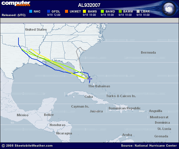
Heres one for the LBAR hall of fame.
0 likes
-
Air Force Met
- Military Met

- Posts: 4372
- Age: 57
- Joined: Tue Jul 08, 2003 9:30 am
- Location: Roan Mountain, TN
Re: INVEST 93L: Discussion & Images=5:30 PM TWO at page 18
miamicanes177 wrote:SHIPS has the shear below 10kts for the crucial time of 36-84 hours when it is over the highest heat content and 30 deg C SST. This is how I come up with the solution Jerry will be huge. Humberto did not have much time at all and look what it did. This will have plenty of time over water. The tropics can do amazing things with the right environment.
I guess you missed my post about the SHIPS...and the reason it is showing 10 knots of shear during that time period is because this system is going to be under the upper low...so its not under 10 kts of anticyclonic outflow...its under 10 kts of cyclonic flow...
That is a big difference....and an important one.
0 likes
-
CrazyC83
- Professional-Met
- Posts: 34315
- Joined: Tue Mar 07, 2006 11:57 pm
- Location: Deep South, for the first time!
Re: INVEST 93L: East of South Florida: Discussion & Images
Category 5 wrote:Heres one for the LBAR hall of fame.
Those seem to just miss the Loop Current.
0 likes

Re: INVEST 93L: Discussion & Images=5:30 PM TWO at page 18
Air Force Met wrote:miamicanes177 wrote:SHIPS has the shear below 10kts for the crucial time of 36-84 hours when it is over the highest heat content and 30 deg C SST. This is how I come up with the solution Jerry will be huge. Humberto did not have much time at all and look what it did. This will have plenty of time over water. The tropics can do amazing things with the right environment.
I guess you missed my post about the SHIPS...and the reason it is showing 10 knots of shear during that time period is because this system is going to be under the upper low...so its not under 10 kts of anticyclonic outflow...its under 10 kts of cyclonic flow...
That is a big difference....and an important one.
Which ULL? The one diving WSW from Fl right now? The low level center would need to start haulin to catch up with that ULL....is the ULL suppose to stall out in the GOM?
0 likes
-
jhamps10
Re: INVEST 93L: East of South Florida: Discussion & Images
CrazyC83 wrote:Category 5 wrote:Heres one for the LBAR hall of fame.
Those seem to just miss the Loop Current.
yeah, however the GFS does NOT miss the LC.
Which speaking of LC's, Larry Cosgrove adds this for discussion.
http://www.stormvista.com/forum/index.p ... topic=2618
0 likes
-
wxmann_91

- Category 5
- Posts: 8007
- Age: 34
- Joined: Fri Jul 15, 2005 2:49 pm
- Location: Southern California
- Contact:
Re:
Stratosphere747 wrote:People are constantly getting to stuck on what happened in 05 with Katrina and Rita, and trying to correlate that anything that traverses the LC is going to bomb into a cat5.
It's more hype than what Accuweather throws around sometimes....
lol, true.
In fact, only 4 hurricanes since 1950 have developed in the GOM and strengthened to Major status prior to landfall.
Audrey (1957), Anita (1977), Alicia (1983), and Bret (1999).
Goes to show how rare it is. Upper air environment is not perfect either. Basically I think a low-end hurricane is possible, but that's about it.
0 likes
-
Chris_in_Tampa
- Category 5
- Posts: 5101
- Age: 42
- Joined: Thu Jun 21, 2007 11:06 pm
- Location: Tampa, Florida, USA
- Contact:
Re: INVEST 93L: East of South Florida: Discussion & Images
RL3AO wrote:That pressure can't be right.Code: Select all
Observed at:  Foots Cay, Foots Cay, Abaco
Elevation:    30 ft / 9 m
Temperature:  76.4 °F / 24 °C
Humidity:     100%
Dew Point:    76 °F / 25 °C
Wind:         28.2 mph / 45 km/h  from the East
Wind Gust:    29.9 mph / 48 km/h
Pressure:     29.76 in / 1007.7 hPa
Heat Index:   75 °F / 24 °C
http://www.wunderground.com/weatherstat ... ID=IABACO1
Looking at the past history for the station, the pressure was not that low a few days ago, so it is invalid.
0 likes
Who is online
Users browsing this forum: No registered users and 22 guests