Texas Winter 2025-2026

Winter Weather Discussion

Moderator: S2k Moderators

Forum rules

The posts in this forum are NOT official forecast and should not be used as such. They are just the opinion of the poster and may or may not be backed by sound meteorological data. They are NOT endorsed by any professional institution or
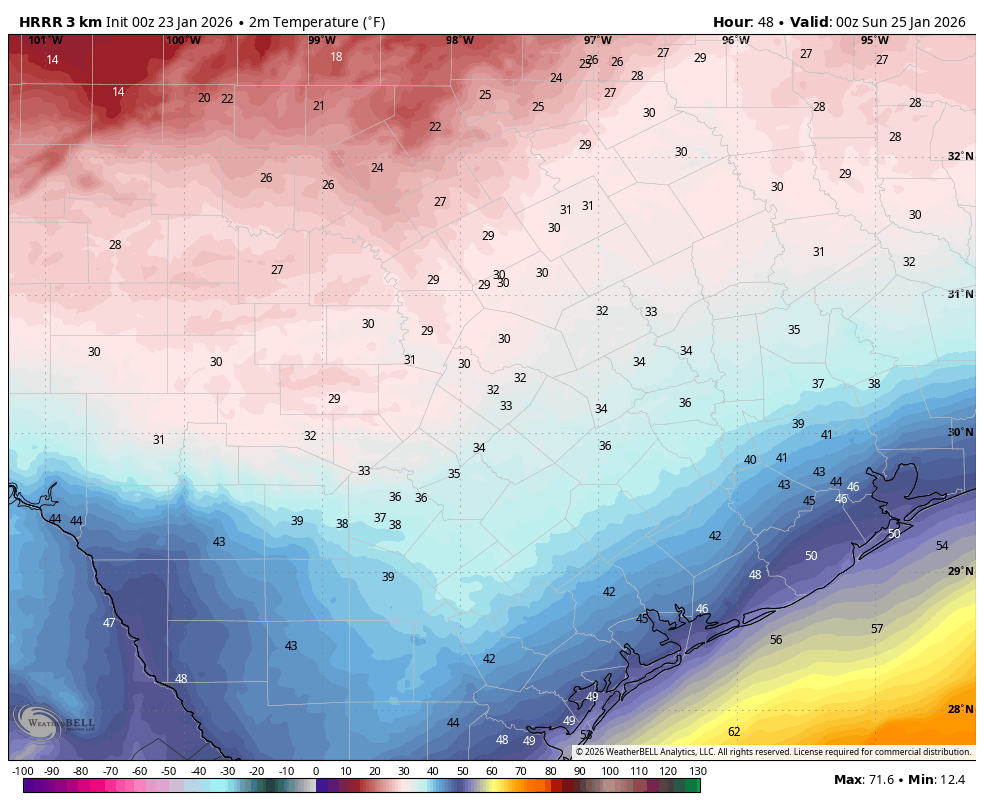
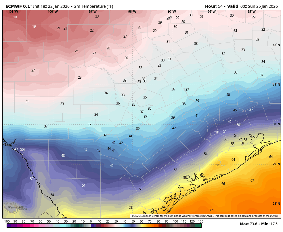
 STORM2K.

Help Support Storm2K
Message
Author
User avatar
Quixotic
Category 3
Category 3
Posts: 864
Joined: Tue Feb 14, 2017 12:27 am
Location: Frisco

Re: Texas Winter 2025-2026

#4041 Postby Quixotic » Thu Jan 22, 2026 8:53 pm

orangeblood wrote:
Iceresistance wrote:Is HRRR bad with moisture? It has trended a bit drier


Yes, notoriously bad…happens almost every winter storm. Just use for temp profiles and wind

Latest HRRR looks lock step with our new AI models :double: . And they will only continue to get better and better

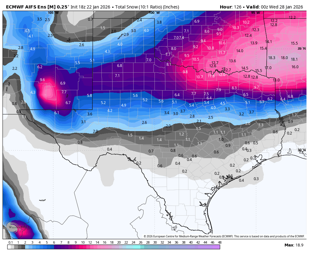
Speaking of, here is what the AI Ensemble members look like snowfall wise. Combo of sleet and snow, incorporates a further south push of colder/quicker air into Texas. For Oklahoma, this is a 10:1 profile snowfall depiction, likely much higher totals up there with higher ratios

https://images.weatherbell.com/model/ecmwf-aifs-ensemble-avg/tx/total_snow_10to1/1769104800/1769558400-bZp73YqAIc8.png


AI versus the combined knowledge of the NWS. I’m betting on humanity.
1 likes   

Brandon8181
S2K Supporter
S2K Supporter
Posts: 428
Age: 42
Joined: Tue Jan 04, 2011 4:52 pm
Location: Tyler, TX
Contact:

Re: Texas Winter 2025-2026

#4042 Postby Brandon8181 » Thu Jan 22, 2026 8:56 pm

Ntxw wrote:Don't forget, the shorter hi res models (including the NAM) are not global models. They do not see beyond their designed region (US.) Once the actual cold air is ground truth then they will initialize it better and trend. It can only see what's there.


Good information here. I knew they weren't Globals, but didn't realize this.
0 likes   
I am not a meteorologist. Any post from me should be taken as hobby or fun educational information, but not an accurate source for weather information. Please, refer to your local weather station or National Weather Service for the most up to date information. :flag:

User avatar
wxman22
Category 5
Category 5
Posts: 1787
Joined: Mon Jan 30, 2006 12:39 am
Location: Wichita Falls, TX
Contact:

Re: Texas Winter 2025-2026

#4043 Postby wxman22 » Thu Jan 22, 2026 8:56 pm

The HRRR ends just as the 2nd wave is about to start. It has 1 inch of QPF here from the first round alone.:double:

Image
Last edited by wxman22 on Thu Jan 22, 2026 9:04 pm, edited 1 time in total.
4 likes   

User avatar
bubba hotep
S2K Supporter
S2K Supporter
Posts: 5932
Joined: Wed Dec 28, 2016 1:00 am
Location: Collin County Texas

Re: Texas Winter 2025-2026

#4044 Postby bubba hotep » Thu Jan 22, 2026 8:58 pm

No surprise, but not only is the surface cooling faster, but the entire column is. It wouldn''t be surprising to see a transition to snow much faster than currently modeled when the 2nd batch of moisture moves through Texas.
11 likes   
Winter time post are almost exclusively focused on the DFW area.

User avatar
Ntxw
Storm2k Moderator
Storm2k Moderator
Posts: 23333
Joined: Wed Oct 21, 2009 6:34 pm
Location: DFW, Texas

Re: Texas Winter 2025-2026

#4045 Postby Ntxw » Thu Jan 22, 2026 9:00 pm

bubba hotep wrote:No surprise, but not only is the surface cooling faster, but the entire column is. It wouldn''t be surprising to see a transition to snow much faster than currently modeled when the 2nd batch of moisture moves through Texas.


Ukmet.
3 likes   
The above post and any post by Ntxw is NOT an official forecast and should not be used as such. It is just the opinion of the poster and may or may not be backed by sound meteorological data. It is NOT endorsed by any professional institution including Storm2k. For official information, please refer to NWS products.

  Help support Storm2K!
Help Support Storm2K

User avatar
Texas Snow
S2K Supporter
S2K Supporter
Posts: 812
Joined: Mon Oct 19, 2015 12:06 pm
Location: N. Dallas & Cedar Creek Lake

Re: Texas Winter 2025-2026

#4046 Postby Texas Snow » Thu Jan 22, 2026 9:00 pm

ATXAG95 wrote:
I am trying to decide if I should keep my husband home on Saturday afternoon to watch the Aggies play basketball rather than watch from our seats in Reed Arena.


Probably depends on where you live. If in College Station or south it’s probably ok. It’s not forecast to drop to freezing there until 10pm Saturday night. (According to NWS point forecast). Of course check the NWS as we get closer.

Yell loud!
Last edited by Texas Snow on Thu Jan 22, 2026 9:01 pm, edited 2 times in total.
1 likes   
"Don't let wishcastin get in the way of your forecastin"

Image

User avatar
bubba hotep
S2K Supporter
S2K Supporter
Posts: 5932
Joined: Wed Dec 28, 2016 1:00 am
Location: Collin County Texas

Re: Texas Winter 2025-2026

#4047 Postby bubba hotep » Thu Jan 22, 2026 9:00 pm

wxman22 wrote:The HRRR ends just as the 2nd wave is about to start. It has 1 inch of QPF from the first round alone.:double:

https://i.ibb.co/9mLNTMxf/CODNEXLAB-FORECAST--HRRR-SGP-winter-ptype-11-100.gif


18z runs showed another 1.5-2" of QPF with the 2nd batch. Add that to the 00z HRRR, which shows Texas being much colder everywhere...
6 likes   
Winter time post are almost exclusively focused on the DFW area.

User avatar
jasons2k
Storm2k Executive
Storm2k Executive
Posts: 8264
Age: 52
Joined: Wed Jul 06, 2005 12:32 pm
Location: The Woodlands, TX

Re: Texas Winter 2025-2026

#4048 Postby jasons2k » Thu Jan 22, 2026 9:01 pm

The freezing line is now in the NW Texas panhandle.
7 likes   

rwfromkansas
Category 5
Category 5
Posts: 2896
Joined: Sat Aug 27, 2005 12:47 am
Location: North Fort Worth

Re: Texas Winter 2025-2026

#4049 Postby rwfromkansas » Thu Jan 22, 2026 9:01 pm

wxman22 wrote:The HRRR ends just as the 2nd wave is about to start. It has 1 inch of QPF from the first round alone.:double:

https://i.ibb.co/9mLNTMxf/CODNEXLAB-FORECAST--HRRR-SGP-winter-ptype-11-100.gif


It still holds that 540 line up quite a ways north, but hard to tell. I wish these GIFS were slower. But, surely the would be inaccurate with the level of cold air arriving.
1 likes   

User avatar
Ntxw
Storm2k Moderator
Storm2k Moderator
Posts: 23333
Joined: Wed Oct 21, 2009 6:34 pm
Location: DFW, Texas

Re: Texas Winter 2025-2026

#4050 Postby Ntxw » Thu Jan 22, 2026 9:03 pm

Brandon8181 wrote:
Ntxw wrote:Don't forget, the shorter hi res models (including the NAM) are not global models. They do not see beyond their designed region (US.) Once the actual cold air is ground truth then they will initialize it better and trend. It can only see what's there.


Good information here. I knew they weren't Globals, but didn't realize this.


We like to use them for temperatures and convection but often it is misinterpreted what they represent. We wait for them because of that direct link, it is less a guess, but rather directive on what's actually there closer to reality. But they have limitations, the further out you go the more it becomes a guess, just like the globals in a sense, without the skill of the medium range. Wheelbarrow is about ~48 hours or less for the short range guidance and really more like 24 hours.
5 likes   
The above post and any post by Ntxw is NOT an official forecast and should not be used as such. It is just the opinion of the poster and may or may not be backed by sound meteorological data. It is NOT endorsed by any professional institution including Storm2k. For official information, please refer to NWS products.


  Help support Storm2K!

Help Support Storm2K


User avatar
wxman22
Category 5
Category 5
Posts: 1787
Joined: Mon Jan 30, 2006 12:39 am
Location: Wichita Falls, TX
Contact:

Re: Texas Winter 2025-2026

#4051 Postby wxman22 » Thu Jan 22, 2026 9:06 pm

If you look at the soundings a lot of what the HRRR is showing as freezing rain is actually sleet.
5 likes   

User avatar
Iceresistance
Category 5
Category 5
Posts: 9520
Age: 22
Joined: Sat Oct 10, 2020 9:45 am
Location: Tecumseh, OK/Norman, OK

Re: Texas Winter 2025-2026

#4052 Postby Iceresistance » Thu Jan 22, 2026 9:10 pm

Snippet of Tulsa AFD, wow

These factors together point to a widespread storm total of 6-12
inches of snow north of I-40. If some of the higher end guidance
were to develop (less likely) it is possible local accumulations
could be as high as 18-20 inches somewhere.
0 likes   
Bill 2015 & Beta 2020

Winter 2020-2021 :cold:

All observations are in Tecumseh, OK unless otherwise noted.

Winter posts are focused mainly for Oklahoma & Texas.

Take any of my forecasts with a grain of salt, refer to the NWS, SPC, and NHC for official information

Never say Never with weather! Because ANYTHING is possible!

Ralph's Weather
S2K Supporter
S2K Supporter
Posts: 3325
Age: 38
Joined: Fri Dec 13, 2013 11:55 am
Location: Lindale, TX
Contact:

Re: Texas Winter 2025-2026

#4053 Postby Ralph's Weather » Thu Jan 22, 2026 9:10 pm

Freeze line is into TX. Tomorrow may be more frozen than expected but moisture will likely be more limited than we thought before. Real game is still Saturday.
2 likes   
Follow on Facebook at Ralph's Weather.

Haddox12
Tropical Low
Tropical Low
Posts: 10
Joined: Thu Aug 24, 2017 11:02 am

Re: Texas Winter 2025-2026

#4054 Postby Haddox12 » Thu Jan 22, 2026 9:12 pm

Gotwood wrote:
DFW Stormwatcher wrote:
Steve wrote:
What you gonna do though but try to help people understand the situation. Some people will listen and some will be hardheaded or initially ambivalent until the reality does hit. Hope it’s more of a party storm and only somewhat of a minor aggravation for everyone.


Gotwood has clearly not been to a grocery store this afternoon. I did my shopping yesterday but had to go to Wal Mart and heb for a few things, it’s mad max out there in north Fort Worth!

Correct that’s why I’m apart of this forum. I did my prep work on Monday.


I stopped on my way home from work on Tuesday and had a beautiful experience at both the grocery store and Home Depot. It was a mess by the same time on Wednesday. I love following you nerds, and I mean that as endearingly as possible.

I don’t get to have any fun during hurricane season but you guys have saved my bacon in the Texas winters and springs for years now.
Last edited by Haddox12 on Thu Jan 22, 2026 9:13 pm, edited 1 time in total.
11 likes   

bohaiboy
Tropical Depression
Tropical Depression
Posts: 88
Joined: Sat Aug 09, 2008 11:20 am

Re: Texas Winter 2025-2026

#4055 Postby bohaiboy » Thu Jan 22, 2026 9:16 pm

When is the eluded to second round supposed to be here? Is it part of this weekend's weather, or a future event?
0 likes   
TW in Texas Hill Country :flag:

LearnedHat
Tropical Depression
Tropical Depression
Posts: 93
Joined: Wed Feb 10, 2010 11:17 am
Location: Keller, TX

Re: Texas Winter 2025-2026

#4056 Postby LearnedHat » Thu Jan 22, 2026 9:19 pm

wxman22 wrote:If you look at the soundings a lot of what the HRRR is showing as freezing rain is actually sleet.


Because of the temperature or the thickness of the surface layer - or is the nose not quite as warm.
1 likes   

User avatar
txtwister78
Category 5
Category 5
Posts: 2072
Joined: Wed Jan 30, 2019 12:56 pm
Location: San Antonio

Re: Texas Winter 2025-2026

#4057 Postby txtwister78 » Thu Jan 22, 2026 9:31 pm

As I've been highlighting for the past few days this makes all the difference in terms of impacts for folks further south in particular regarding the potential for higher ice accumulations and so very important to keep tabs on this as I think the NWS offices further south along with local media in my area in particular may be playing a little catch up with this reality.

Arctic air especially when you're talking about a 1052 high centered across the midwest is going to push and arrive much faster. Just seen it far too many times and so globals (in particular Euro which many within media use) are not as helpful across the south when it comes to surface temps/shallow arctic air.

Below you can see already the comparison between the HRRR and Euro temps at 6PM Saturday. My guess is the HRRR will continue to trend colder by then in future runs in addition to other short range guidance such as the WRF-NSSL and ARW.

Image

Image
Last edited by txtwister78 on Thu Jan 22, 2026 9:33 pm, edited 2 times in total.
4 likes   

DallasAg
Tropical Storm
Tropical Storm
Posts: 210
Joined: Sun Feb 14, 2021 11:20 am
Location: Dallas, TX

Re: Texas Winter 2025-2026

#4058 Postby DallasAg » Thu Jan 22, 2026 9:32 pm

Quixotic wrote:I’m leaning more Dec 2013 than Feb 2011. 2013 was a shorter event. 2011 we had thunder sleet initially, a 24 hour pause and then the 4-6” snow thump. This time it looks like a 36 hour event with mostly sleet with a 2” snow thump. 2011 was like maybe an 1” of sleet/ice. Completely undriveable. Once the snow hit traction was available however my front fender was plowing through snow in curb drifts. Either way, it’s better than 85 degree Christmas.

This setup reminds me a lot of the event we had March 4-5, 1989. Arctic front blew through early morning hours of the 4th. We had several rounds of sleet, including some thunder sleet, that lasted through mid-afternoon. Then a lull in the action until late night on the 4th/5th when another round came through with some heavier sleet that changed to a pretty decent snow. I don't think that storm had the size and heft of this one in terms of regional scope though.
4 likes   

User avatar
Cerlin
Category 5
Category 5
Posts: 1186
Age: 23
Joined: Thu Dec 08, 2016 12:06 am
Location: Norman, OK

Re: Texas Winter 2025-2026

#4059 Postby Cerlin » Thu Jan 22, 2026 9:33 pm

bohaiboy wrote:When is the eluded to second round supposed to be here? Is it part of this weekend's weather, or a future event?

For NTX at least, there is a break of precipitation Saturday that then resumes heavier precipitation associated with stronger winds early Sunday morning. Much better snow chance with that
4 likes   
Graduate Meteorology Student at the University of Oklahoma!
All opinions independent of employers and the university.

LearnedHat
Tropical Depression
Tropical Depression
Posts: 93
Joined: Wed Feb 10, 2010 11:17 am
Location: Keller, TX

Re: Texas Winter 2025-2026

#4060 Postby LearnedHat » Thu Jan 22, 2026 9:35 pm

txtwister78 wrote:As I've been highlighting for the past few days this makes all the difference in terms of impacts for folks further south in particular regarding the potential for higher ice accumulations and so very important to keep tabs on this as I think the NWS offices further south along with local media in my area in particular may be playing a little catch up with this reality.

Arctic air especially when you're talking about a 1052 high centered across the midwest is going to push and arrive much faster. Just seen it far too many times and so globals (in particular Euro which many within media use) are not as helpful across the south when it comes to surface temps/shallow arctic air.

Below you can see already the comparison between the HRRR and Euro temps at 6PM Saturday. My guess is the HRRR will continue to trend colder by then in future runs in addition to other short range guidance such as the WRF-NSSL and ARW.

https://images.weatherbell.com/model/hrrr/austin/t2m_f/1769126400/1769299200-7Xm5MCKlpYw.png

https://images.weatherbell.com/model/ecmwf-deterministic/austin/t2m_f/1769104800/1769299200-jLboTTQ9Nmc.png


I am Where’s Waldo-ing the crap out of that but having trouble spotting the difference.

Okay - got it now - think it changed.
0 likes   


Return to “Winter Weather”

Who is online

Users browsing this forum: Lagreeneyes03 and 197 guests