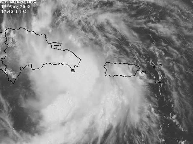
NEXRAD wrote:My best radar-estimated possible LLC is near 18.8N, 68.7W. On visible imagery, though, it seems like it might be a little north and west of this position, though.
- Jay
18.3 68.5
Moderator: S2k Moderators


NEXRAD wrote:My best radar-estimated possible LLC is near 18.8N, 68.7W. On visible imagery, though, it seems like it might be a little north and west of this position, though.
- Jay

Category 5 wrote:If they do find a closed LLC, this will be fay.
17:49:00Z 18.75N 67.77W 962.3 mb
(~ 28.42 inHg) 435 meters
(~ 1,427 feet) 1011.7 mb
(~ 29.88 inHg) - From 139° at 35 knots
(From the SE at ~ 40.2 mph) 21.9°C
(~ 71.4°F) 17.0°C
(~ 62.6°F) 36 knots
(~ 41.4 mph) 45 knots
(~ 51.7 mph) 0 mm/hr
(~ 0 in/hr) 43.8 knots (~ 50.3 mph)
Tropical Storm 125.0%
jlauderdal wrote:loro-rojo wrote:Two of the local channels here in Miami are already doing hourly updates on this system, and are calling for people to start preparing for a possible hurricane...
which channels are telling people to prepare for a hurricane?

MiamiensisWx wrote:dixiebreeze wrote:Everyone should keep in mind the unpredictability of tropical storms. There was no "good reason" to think Hurricane Charlie would suddenly take a hard right into Punta Gorda, Florida -- but it did.
Bolded statement is false. There was abundant evidence for the turn. Additionally, 1933 likely featured more than 21 NS, so I always believed (rare) seasons with more than 21 NS were possible.
I have yet to see any conclusive evidence supporting the possibility of a major hurricane from this one. I'm not condescending; I'm merely asking for proof or possible answers.
fci wrote:MiamiensisWx wrote:dixiebreeze wrote:Everyone should keep in mind the unpredictability of tropical storms. There was no "good reason" to think Hurricane Charlie would suddenly take a hard right into Punta Gorda, Florida -- but it did.
Bolded statement is false. There was abundant evidence for the turn. Additionally, 1933 likely featured more than 21 NS, so I always believed (rare) seasons with more than 21 NS were possible.
I have yet to see any conclusive evidence supporting the possibility of a major hurricane from this one. I'm not condescending; I'm merely asking for proof or possible answers.
QUick jump in here:
I think the reaction to your original comment was swift because you appeared to ridicule those who cited the chance for a major YESTERDAY, not today.


GreenSky wrote:NEXRAD wrote:My best radar-estimated possible LLC is near 18.8N, 68.7W. On visible imagery, though, it seems like it might be a little north and west of this position, though.
- Jay
So with that current position and its current heading, 92L should be skirmishing the northern coast of DR...not the southern coast, right?
Or do you think it is going to be going right through DR's spine, like FOX13WEATHER suggested?
I take your analysis seriously NexRad, always a pleasure reading your analysis.
loro-rojo wrote:Two of the local channels here in Miami are already doing hourly updates on this system, and are calling for people to start preparing for a possible hurricane...


cycloneye wrote:SSD dvorak:
15/1745 UTC 18.1N 68.6W T2.5/2.5 92L -- Atlantic Ocean
gatorcane wrote:well can we agree Hispaniola just isn't weakening this thing as we hoped??? Gosh it keeps looking better by the hour
Users browsing this forum: No registered users and 23 guests