URNT15 KNHC 031837
AF304 0506A ERIKA HDOB 14 20090903
182700 1638N 06555W 9765 00278 0080 +245 +124 061011 011 017 000 00
182730 1639N 06554W 9762 00280 0079 +245 +124 058010 011 019 000 00
182800 1641N 06553W 9764 00278 0079 +245 +124 060011 011 020 000 00
182830 1643N 06552W 9765 00275 0078 +245 +125 062012 012 020 000 00
182900 1644N 06552W 9763 00278 0077 +245 +125 068011 011 017 000 00
182930 1646N 06551W 9763 00276 0076 +243 +124 066010 011 018 000 00
183000 1647N 06550W 9761 00276 0075 +244 +124 070010 012 016 000 00
183030 1649N 06549W 9764 00275 0075 +245 +124 071013 014 016 001 00
183100 1651N 06549W 9763 00275 0075 +245 +124 068013 014 016 000 00
183130 1652N 06548W 9762 00276 0075 +245 +125 067013 013 018 000 00
183200 1654N 06547W 9763 00275 0075 +245 +125 066013 013 018 000 00
183230 1655N 06547W 9762 00276 0076 +245 +126 068013 013 019 000 00
183300 1657N 06546W 9763 00278 0077 +245 +127 068014 014 022 000 00
183330 1658N 06545W 9762 00278 0076 +245 +128 070014 015 021 000 00
183400 1700N 06544W 9764 00275 0076 +245 +129 070015 016 023 000 00
183430 1702N 06544W 9763 00276 0076 +245 +129 072016 016 023 000 00
183500 1703N 06543W 9762 00276 0076 +245 +130 069016 016 023 000 00
183530 1705N 06542W 9760 00280 0076 +245 +130 072017 017 023 000 00
183600 1706N 06541W 9764 00275 0077 +245 +131 069017 018 024 000 00
183630 1708N 06541W 9764 00276 0077 +245 +131 069017 018 023 000 00
ATL : TROPICAL DEPRESSION ERIKA (06L)
Moderator: S2k Moderators
-
tolakram
- Admin

- Posts: 20176
- Age: 62
- Joined: Sun Aug 27, 2006 8:23 pm
- Location: Florence, KY (name is Mark)
Re: ATL : TROPICAL STORM ERIKA (06L)
mascpa wrote:Then you must be surprised that NHC is still classifying it as a tropical storm ???
They won't update till 5pm at which time, if best track is still a TD, they will downgrade unless recon finds something of interest.
0 likes
-
Blown Away

- S2K Supporter

- Posts: 10253
- Joined: Wed May 26, 2004 6:17 am
Re: ATL : TROPICAL STORM ERIKA (06L)
The LLC is on blast off to the W now. The models were so bad w/ Erika, if you look at the recent model runs for the GFS, GFDL, HWRF they have the LLC taking alomst 24 hours to reach the longitude it's at rate now. I can't recall a named system that was forecasted to dissipate by the NHC have most models predicting development and some a major hurricane. Is it possible the models are picking up on a center redevloping near the convection. Erika looks done to me. What a crazy storm this has been. 
0 likes
-
wxman57

- Moderator-Pro Met

- Posts: 23170
- Age: 68
- Joined: Sat Jun 21, 2003 8:06 pm
- Location: Houston, TX (southwest)
Re: ATL : TROPICAL STORM ERIKA (06L)
The only question is whether they'll still call it a TD at 4pm or a remnant low. I don't think a good argument can be made to call it a TD, based on the weakness of the LLC and complete lack of convection anywhere near what remains of the center.
0 likes
-
HenkL
- S2K Supporter
- Posts: 2401
- Joined: Fri Sep 10, 2004 5:33 pm
- Location: Groningen, The Netherlands
- Contact:
URNT15 KNHC 031846
AF304 0506A ERIKA HDOB 15 20090903
183700 1709N 06540W 9763 00278 0077 +245 +131 070018 018 024 000 00
183730 1711N 06539W 9761 00278 0076 +245 +132 069017 017 025 000 00
183800 1713N 06538W 9764 00278 0077 +245 +132 070018 018 022 001 00
183830 1714N 06538W 9762 00278 0077 +242 +132 073018 018 024 000 00
183900 1716N 06537W 9764 00278 0078 +240 +132 073019 020 025 001 00
183930 1717N 06536W 9761 00279 0078 +240 +132 076020 021 027 000 03
184000 1719N 06535W 9764 00278 0078 +241 +132 078019 019 021 000 00
184030 1720N 06535W 9764 00276 0078 +242 +132 080020 020 020 001 00
184100 1722N 06534W 9764 00278 0077 +242 +132 080020 021 021 000 00
184130 1723N 06533W 9761 00280 0078 +240 +132 079020 021 020 000 00
184200 1725N 06532W 9764 00278 0079 +240 +132 081020 021 021 000 00
184230 1727N 06532W 9761 00280 0079 +240 +132 083021 022 020 000 00
184300 1728N 06531W 9764 00279 0080 +240 +132 086021 022 023 000 03
184330 1729N 06530W 9758 00283 0079 +242 +132 081018 019 999 999 03
184400 1728N 06528W 9761 00283 0079 +245 +132 069017 018 999 999 03
184430 1727N 06527W 9762 00280 0080 +241 +133 070017 018 999 999 03
184500 1725N 06526W 9763 00279 0079 +241 +134 071017 017 999 999 03
184530 1724N 06525W 9763 00279 0079 +240 +135 071016 016 999 999 03
184600 1723N 06524W 9762 00280 0080 +240 +136 069015 015 018 000 00
184630 1721N 06522W 9762 00283 0082 +240 +136 071016 017 018 000 00
0 likes
-
cycloneye

- Admin
- Posts: 149213
- Age: 69
- Joined: Thu Oct 10, 2002 10:54 am
- Location: San Juan, Puerto Rico
Re: ATL : TROPICAL STORM ERIKA (06L)
wxman57 wrote:The only question is whether they'll still call it a TD at 4pm or a remnant low. I don't think a good argument can be made to call it a TD, based on the weakness of the LLC and complete lack of convection anywhere near what remains of the center.
Also,the reports from the islands havent shown all day strong winds at all.
0 likes
Re: ATL : TROPICAL STORM ERIKA (06L)
BatzVI wrote:At this point, I don't think we're going to get much more rain than what we already received....nothing more than a typical summer shower is what it looks like....
We would have liked some rain, but we have had hazy sunshine almost all day on Anguilla as Erika appears to be shrinking away from us to the south.
0 likes


-
jlauderdal
- S2K Supporter
- Posts: 7240
- Joined: Wed May 19, 2004 5:46 am
- Location: NE Fort Lauderdale
- Contact:
Re: ATL : TROPICAL STORM ERIKA (06L)
x-y-no wrote:jlauderdal wrote:I guess she lives for at least a few more hours, i remember the noname storm about 8 years ago in sofla, was a bigger event than any cane that was in our vicinty in the last ten years.
Bigger than Wilma? No way ...
Not even bigger than Katrina, if you consider the amount of damage she did in the Coral Gables/South Miami/West Miami area.
my error, i was typing and on phone and was going to type wilma, noname caused alot of flooding, i think it was up there with katrina though as far as damage goes and probably more.
0 likes
-
wxman57
- Moderator-Pro Met
- Posts: 23170
- Age: 68
- Joined: Sat Jun 21, 2003 8:06 pm
- Location: Houston, TX (southwest)
Re: ATL : TROPICAL STORM ERIKA (06L)
cycloneye wrote:wxman57 wrote:The only question is whether they'll still call it a TD at 4pm or a remnant low. I don't think a good argument can be made to call it a TD, based on the weakness of the LLC and complete lack of convection anywhere near what remains of the center.
Also,the reports from the islands havent shown all day strong winds at all.
As much as the convection is decreasing, Luis, you may not even get TOO much rain there. Max winds within 100 miles of the center are only 15-20 mph at present. A little weaker than normal easterly trades in the region.
0 likes
-
HURAKAN

- Professional-Met

- Posts: 46084
- Age: 39
- Joined: Thu May 20, 2004 4:34 pm
- Location: Key West, FL
- Contact:
Re: ATL : TROPICAL STORM ERIKA (06L)
jlauderdal wrote:x-y-no wrote:jlauderdal wrote:I guess she lives for at least a few more hours, i remember the noname storm about 8 years ago in sofla, was a bigger event than any cane that was in our vicinty in the last ten years.
Bigger than Wilma? No way ...
Not even bigger than Katrina, if you consider the amount of damage she did in the Coral Gables/South Miami/West Miami area.
my error, i was typing and on phone and was going to type wilma, noname caused alot of flooding, i think it was up there with katrina though as far as damage goes and probably more.
To me the noname storm (Leslie later on) was more destructive because where I lived had like two feet of water inside the house and that stayed for a few days. Nothing was lost. During Katrina and Wilma it was more a wind event and a few branches from the neighbor's avocado tree fell in my yard. That was all!
Back to Erika!
0 likes
-
Evil Jeremy

- S2K Supporter
- Posts: 5463
- Age: 32
- Joined: Mon Apr 10, 2006 2:10 pm
- Location: Los Angeles, CA
Re: ATL : TROPICAL STORM ERIKA (06L)
wxman57 wrote:The only question is whether they'll still call it a TD at 4pm or a remnant low. I don't think a good argument can be made to call it a TD, based on the weakness of the LLC and complete lack of convection anywhere near what remains of the center.
I think it is a remnant low by now, but I think they will call it a TD.
0 likes
-
HURAKAN
- Professional-Met
- Posts: 46084
- Age: 39
- Joined: Thu May 20, 2004 4:34 pm
- Location: Key West, FL
- Contact:
Re: ATL : TROPICAL STORM ERIKA (06L)
Evil Jeremy wrote:wxman57 wrote:The only question is whether they'll still call it a TD at 4pm or a remnant low. I don't think a good argument can be made to call it a TD, based on the weakness of the LLC and complete lack of convection anywhere near what remains of the center.
I think it is a remnant low by now, but I think they will call it a TD.
Sometimes it pays to be conservative but since conditions are expected to get worse, it may be time to pull the plugs.
0 likes
-
HenkL
- S2K Supporter
- Posts: 2401
- Joined: Fri Sep 10, 2004 5:33 pm
- Location: Groningen, The Netherlands
- Contact:
URNT15 KNHC 031857
AF304 0506A ERIKA HDOB 16 20090903
184700 1720N 06521W 9760 00285 0083 +240 +137 072017 019 021 000 00
184730 1719N 06520W 9763 00281 0083 +240 +137 070017 017 022 000 00
184800 1717N 06519W 9764 00281 0083 +240 +137 071016 017 017 000 00
184830 1716N 06518W 9760 00285 0083 +236 +137 077015 016 017 001 00
184900 1715N 06516W 9762 00281 0082 +237 +136 082016 016 017 000 00
184930 1713N 06515W 9765 00280 0083 +235 +135 079016 016 020 000 03
185000 1712N 06515W 9757 00287 0082 +239 +133 073016 016 016 000 03
185030 1710N 06514W 9766 00278 0081 +240 +132 073017 018 018 001 00
185100 1708N 06514W 9764 00280 0080 +240 +132 071016 017 019 000 00
185130 1706N 06513W 9763 00279 0080 +240 +132 072016 017 021 000 00
185200 1704N 06513W 9762 00279 0079 +236 +132 069016 016 019 000 00
185230 1703N 06512W 9762 00278 0078 +239 +133 069015 015 016 000 00
185300 1701N 06512W 9764 00278 0078 +240 +133 064015 016 020 000 00
185330 1659N 06511W 9762 00278 0078 +240 +134 065017 017 018 000 00
185400 1657N 06511W 9762 00278 0078 +235 +135 064014 015 019 000 00
185430 1656N 06510W 9808 00237 0078 +236 +135 063013 014 019 000 00
185500 1654N 06510W 9836 00211 0076 +240 +135 060015 015 021 000 00
185530 1652N 06509W 9834 00212 0076 +240 +135 059014 015 019 000 00
185600 1650N 06509W 9831 00214 0075 +240 +135 059014 015 018 000 03
185630 1649N 06508W 9834 00211 0075 +240 +136 057013 014 020 000 00
0 likes
Re: ATL : TROPICAL STORM ERIKA (06L)
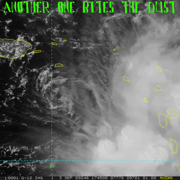
The Eastern Caribbean zone of tropical death is stripping Erika of its convection.
The weak swirl surface spiral is heading west on last night's GFDL track.
1008mb. As long as convection persists it has a chance at reformation.
The weak swirl surface spiral is heading west on last night's GFDL track.
1008mb. As long as convection persists it has a chance at reformation.
Last edited by Sanibel on Thu Sep 03, 2009 2:09 pm, edited 1 time in total.
0 likes
-
storms NC

- Tropical Storm

- Posts: 247
- Age: 70
- Joined: Tue Sep 14, 2004 2:41 pm
- Location: Coast of NC & southwest coast of Fla
I am going to laugh my head off by
Just my 2 cents not NHC
Monday when she refires back up to a TS. And I don't think she will just go poof in thin air either. She will hang on to what she has till she get to the Bahamas. Yes she will go down to a TD and maybe a open wave. But she will be back. I may eat crow. Had it many times.You will see her fire up and down for the next few days. But by Sunday or Monday she will be there to stay and not fall back to a Low any more till she is inland somewhere or out to sea.
0 likes
Who is online
Users browsing this forum: No registered users and 8 guests