


Florida Weather
Moderator: S2k Moderators
Forum rules

The posts in this forum are NOT official forecast and should not be used as such. They are just the opinion of the poster and may or may not be backed by sound meteorological data. They are NOT endorsed by any professional institution or STORM2K.

Re: Florida Weather Thread: SLGT risk D1-2 N/CFL
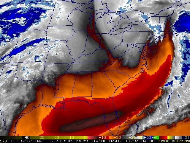
Discussion from NWS Miami earlier this morning.... gist of what they are saying (i think...pretty technical discussion if i do say so) is that some storms are possible into se fl....but the dynamics for severe weather are not expected. Line of rain and storms may also break up some as it reaches the forecast area.
DISCUSSION...
MODEL GUIDANCE IS IN GOOD AGREEMENT MOVING THE FRONT TO A LINE
ROUGHLY FROM VRB- APF AROUND 18Z AND THEN CLEARING THE PENINSULA BY SUNSET.
AHEAD OF THE FRONT MODEL FCST SOUNDINGS ARE SHOWING THE POTENTIAL FOR 1500 J/KG
OF CAPE ACROSS THE ENTIRE CWA AHEAD OF THE FRONT. THIS MAY BE A
LITTLE HARDER TO ACHIEVE UP AROUND LAKE OKEECHOBEE REGION AS THE
FRONT GETS THERE FIRST WITH MORE CLOUDS AHEAD OF IT...HOWEVER GFS
INDICATES POTENTIAL FOR LINE OF TSTMS TO SURVIVE INTO OUR NORTHERN
CWA THROUGH THE MORNING WITH DECENT OMEGA TO COMBINE WITH THE
INSTABILITY AND PWATS INCREASING TO NEAR 1.75 INCHES. GUSTY SW
WINDS COULD MAKE IT A WARM DAY ALONG THE EAST COAST...ESPECIALLY IF
CLOUDS HOLD OFF...HOWEVER THICK HIGH CLOUDS APPEAR HEADED FOR THE
AREA AT THIS POINT. ONLY ISSUE COULD BE SCT SHOWERS OR A STORM OR
TWO DEVELOPING AT JUST ABOUT ANY TIME AHEAD OF MAIN LINE IN
UNSTABLE ENVIRONMENT.
MID LEVEL LAPSE RATES ARE NEARLY MOIST
ADIABATIC BY THIS AFTERNOON...AND OMEGA SHIFTS WELL NE OF THE
REGION AS THE FRONT MOVES THROUGH. THIS LEADS ME TO BELIEVE THE
SOLID LINE OF SHOWERS/STORMS ACROSS THE LAKE REGION WILL BEGIN TO
BREAK UP AS IT MOVES THROUGH SOUTH FL...ESPECIALLY SINCE BEST LLJ
SHIFTS NE OFF THE ECENTRAL FL COAST...BUT GIVEN INSTABILITY THINK
SOME STORMS WILL HOLD TOGETHER ALL THE WAY TO THE SE COAST.
OVERALL...DEEP LAYER SW FLOW WITH 40-50KT FLOW AT 500MB FAVORS
SOME STORM ORGANIZATION...BUT WITH WINDS BELOW 10K FT GENERALLY AOB
30KTS AND LITTLE DRY AIR BELOW CLOUD BASE THINK OVERALL POTENTIAL
FOR DOWNWARD MOMENTUM TRANSPORT IS LOW...AND THUS ANY SEVERE
THREAT APPEARS VERY ISOLD AT THIS POINT.
http://www.srh.noaa.gov/fwd/productview ... &version=0
0 likes

-
Tampa Bay Hurricane

- Category 5

- Posts: 5597
- Age: 38
- Joined: Fri Jul 22, 2005 7:54 pm
- Location: St. Petersburg, FL

Re: Florida Weather Thread: SLGT risk D1-2 N/CFL
Rain has made limited progress to the south and east during the last 60-90 min...front slowing up (was forecast to do so)

0 likes

Re: Florida Weather Thread: SLGT risk D1-2 N/CFL
About a 1/4 inch of much needed rain. We're lucky we got what we did since it dried up right after it passed us.
0 likes
-
gatorcane

- S2K Supporter

- Posts: 23708
- Age: 48
- Joined: Sun Mar 13, 2005 3:54 pm
- Location: Boca Raton, FL
Re: Florida Weather Thread: SLGT risk D1-2 N/CFL
bust for most of South Florida -- the line fizzled out quite a bit. At my house I managed to get under an isolated heavy downpour that lasted 10 minutes.
But generally speaking this was not a South Florida rain event this time as the cold front is rapidly losing its punch and fizzling as it heads south.
But generally speaking this was not a South Florida rain event this time as the cold front is rapidly losing its punch and fizzling as it heads south.
0 likes
Re: Florida Weather Thread: SLGT risk D1-2 N/CFL
Line really started to lose its punch and fizzle as it moved through (current radar loop shown below)....most areas in se fl saw a quick trace to 0.25" in isolated spots.
jinftl wrote:Rain has made limited progress to the south and east during the last 60-90 min...front slowing up (was forecast to do so)
0 likes
-
JonathanBelles
- Professional-Met

- Posts: 11430
- Age: 35
- Joined: Sat Dec 24, 2005 9:00 pm
- Location: School: Florida State University (Tallahassee, FL) Home: St. Petersburg, Florida
- Contact:
-
JonathanBelles
- Professional-Met
- Posts: 11430
- Age: 35
- Joined: Sat Dec 24, 2005 9:00 pm
- Location: School: Florida State University (Tallahassee, FL) Home: St. Petersburg, Florida
- Contact:
 Why is it gonna be so cold up there, and quite warm here tonight? I want 40's lol.

-
HURAKAN

- Professional-Met
- Posts: 46084
- Age: 39
- Joined: Thu May 20, 2004 4:34 pm
- Location: Key West, FL
- Contact:
Re: Florida Weather Thread: SLGT risk D1-2 N/CFL
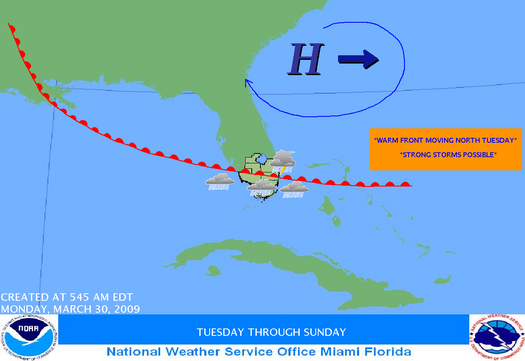
"THE FRONTAL BOUNDARY WILL MOVE BACK NORTH TUESDAY PRODUCING SCATTERED SHOWERS AND ISOLATED THUNDERSTORMS. A FEW THUNDERSTORMS COULD BECOME STRONG WITH STRONG GUSTY WINDS. THE FRONT WILL THEN MOVE NORTH OF THE LOCAL AREA BY WEDNESDAY."
link: http://www.srh.weather.gov/mfl/gcast/
Crossing fingers.
0 likes
Re: Florida Weather Thread: SLGT risk D1-2 N/CFL
As of now, low rain chances across south florida this week into the weekend...certainly no large-scale rain event...just scattered showers. Very warm week on tap.
NWS Forecast for: Miami FL
Issued by: National Weather Service Miami - South Florida
Last Update: 10:25 am EDT Mar 30, 2009
--------------------------------------------------------------------------------
Today: A 10 percent chance of showers. Partly cloudy, with a high near 81.
Tonight: A 20 percent chance of showers. Partly cloudy, with a low around 73.
Tuesday: A 20 percent chance of showers and thunderstorms. Partly cloudy, with a high near 82.
Tuesday Night: A slight chance of showers. Partly cloudy, with a low around 73.
Wednesday: A 10 percent chance of showers. Partly cloudy, with a high near 86.
Wednesday Night: Partly cloudy, with a low around 71.
Thursday: Mostly sunny, with a high near 86.
Thursday Night: Partly cloudy, with a low around 71. .
Friday: A 20 percent chance of showers. Partly cloudy, with a high near 86.
Friday Night: A 10 percent chance of showers. Partly cloudy, with a low around 72.
Saturday: Mostly sunny, with a high near 86.
Saturday Night: Partly cloudy, with a low around 71.
Sunday: Mostly sunny, with a high near 86
0 likes
-
DESTRUCTION5

- Category 5
- Posts: 4430
- Age: 44
- Joined: Wed Sep 03, 2003 11:25 am
- Location: Stuart, FL
Re: Florida Weather Thread: SLGT risk D1-2 N/CFL
Cool today. Enjoy it while it lasts.
73% humidity - Dew Point 53 - High around 77* expected.
73% humidity - Dew Point 53 - High around 77* expected.
0 likes
Return to “USA & Caribbean Weather”
Who is online
Users browsing this forum: Brent and 35 guests