8 pm:
THIS SYSTEM HAS A HIGH CHANCE...70 PERCENT...OF BECOMING A TROPICAL CYCLONE DURING THE NEXT 48 HOURS.
ATL: CHANTAL - Post-Tropical
Moderator: S2k Moderators
-
summersquall

- Tropical Storm

- Posts: 230
- Joined: Wed Jun 16, 2010 11:23 am
- Location: Jensen Beach FL 27°N 80°W (roughly)
0 likes
My posts should NEVER, EVER, EVER be construed as an official forecast as I know virtually nada respecting the finer points of meteorology. Consequently, my posts are obviously NOT endorsed by any professional institution or the good folks at storm2k.org. For official information please refer to the weather gurus at the NHC and NWS.
-
torrea40
Re: ATL: INVEST 95L - Discussion
TROPICAL WEATHER OUTLOOK
NWS NATIONAL HURRICANE CENTER MIAMI FL
800 PM EDT SUN JUL 7 2013
FOR THE NORTH ATLANTIC...CARIBBEAN SEA AND THE GULF OF MEXICO...
A STRONG TROPICAL WAVE LOCATED ABOUT 1050 MILES EAST-SOUTHEAST OF
THE WINDWARD ISLANDS IS MOVING WEST-NORTHWESTWARD AT AROUND 25 MPH.
SATELLITE IMAGERY INDICATES THAT SHOWER AND THUNDERSTORM ACTIVITY
HAS INCREASED IN ORGANIZATION SINCE THIS AFTERNOON. ENVIRONMENTAL
CONDITIONS ARE CONDUCIVE FOR ADDITIONAL DEVELOPMENT...AND THIS
DISTURBANCE COULD BECOME A TROPICAL DEPRESSION OR TROPICAL STORM
LATER TONIGHT OR ON MONDAY. THIS SYSTEM HAS A HIGH CHANCE...70
PERCENT...OF BECOMING A TROPICAL CYCLONE DURING THE NEXT 48 HOURS.
IF DEVELOPMENT OCCURS...TROPICAL STORM WARNINGS WOULD LIKELY BE
ISSUED FOR PORTIONS OF THE LESSER ANTILLES. REGARDLESS OF
DEVELOPMENT...THIS SYSTEM IS EXPECTED TO PRODUCE LOCALLY HEAVY
RAINS AND WINDS TO TROPICAL STORM FORCE IN SQUALLS OVER PORTIONS OF
THE LESSER ANTILLES ON MONDAY NIGHT AND TUESDAY. AN AIR FORCE
RESERVE HURRICANE HUNTER AIRCRAFT IS SCHEDULED TO INVESTIGATE THE
DISTURBANCE ON MONDAY AFTERNOON.
ELSEWHERE...TROPIC
0 likes
-
SapphireSea
- Category 1

- Posts: 430
- Joined: Wed Aug 24, 2005 12:13 pm
- Location: Miami, FL
Re: ATL: INVEST 95L - Models
Steve H. wrote:Pleeeassseeee. How do you even know there will be land interaction? Way too early to know. Models will be adjusting as 95L moves toward the west. May not even survive as it approaches the Caribbean, though I think it may. Could cruise right into the gulf if it keeps low latitude.
It's all about speculation using model data. You are correct in a way, but xtrap shows a system gaining latitude, moving quickly, it could be at the islands as early as late tomorrow. Slowing down some maybe under PR and or Hisp in 2 maybe 3 days. Looking at model data consensus shifting right, land interaction is not out of the cards by a longshot. But yes, still speculation. Could end up crashing into S.Amer or Trek right onto the EPAC who knows.
This post is NOT AN OFFICIAL FORECAST and should not be used as such. It is just the opinion of the poster and may or may not be backed by sound meteorological data. It is NOT endorsed by any professional institution including storm2k.org. For Official Information please refer to the NHC and NWS products.
0 likes
-
Blown Away

- S2K Supporter

- Posts: 10253
- Joined: Wed May 26, 2004 6:17 am
Re: ATL: INVEST 95L - Models
Steve H. wrote:Pleeeassseeee. How do you even know there will be land interaction? Way too early to know. Models will be adjusting as 95L moves toward the west. May not even survive as it approaches the Caribbean, though I think it may. Could cruise right into the gulf if it keeps low latitude.
Most of the models move 95L over/near the big islands, that's what we have to go on for now! Of course 95L could go N or S of the big islands or never develop.
0 likes
Hurricane Eye Experience: David 79, Irene 99, Frances 04, Jeanne 04, Wilma 05… Hurricane Brush Experience: Andrew 92, Erin 95, Floyd 99, Matthew 16, Irma 17, Ian 22, Nicole 22…

Re: ATL: INVEST 95L - Discussion
Exactly what I've been telling folks here on the island. One can only imagine what September will be like! Hopefully, we'll be pleasantly surprised.ozonepete wrote:There's 95L showing up better in the middle of the Atlantic on this wide shot. Looks like it has a friend behind it. Very active easterly wave action for early July. This usually doesn't happen until mid August or so.
Last edited by abajan on Sun Jul 07, 2013 7:05 pm, edited 1 time in total.
0 likes
-
ozonepete
- Professional-Met

- Posts: 4743
- Joined: Mon Sep 07, 2009 3:23 pm
- Location: From Ozone Park, NYC / Now in Brooklyn, NY
Re: ATL: INVEST 95L - Discussion
I guess they'll wait until later tonight to upgrade, but it sure looks like a TS already. At least they've already said that warnings will likely go up for the islands, so I assume some preps get started after the NHC issues a statement like that. Would that be right, Luis? Gusty? Abajan?
Personal Forecast Disclaimer:
The posts in this forum are NOT official forecast and should not be used as such. They are just the opinion of the poster and may or may not be backed by sound meteorological data. They are NOT endorsed by any professional institution or storm2k.org. For official information, please refer to the NHC and NWS products.
0 likes
-
cycloneye

- Admin

- Posts: 149473
- Age: 69
- Joined: Thu Oct 10, 2002 10:54 am
- Location: San Juan, Puerto Rico
Re: ATL: INVEST 95L - Discussion
ozonepete wrote:I guess they'll wait until later tonight to upgrade, but it sure looks like a TS already. At least they've already said that warnings will likely go up for the islands, so I assume some preps get started after the NHC issues a statement like that. Would that be right, Luis? Gusty?
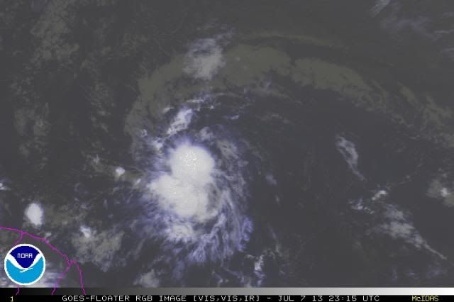
http://i189.photobucket.com/albums/z174/philnyc_2007/satrgb2013-07-072015_zps6d8575fa.jpg
Personal Forecast Disclaimer:
The posts in this forum are NOT official forecast and should not be used as such. They are just the opinion of the poster and may or may not be backed by sound meteorological data. They are NOT endorsed by any professional institution or storm2k.org. For official information, please refer to the NHC and NWS products.
Here in PR,already the talk of the TV mets is about this system but I am sure that the government will make the preparations starting on Monday.
0 likes
Visit the Caribbean-Central America Weather Thread where you can find at first post web cams,radars
and observations from Caribbean basin members Click Here
and observations from Caribbean basin members Click Here
-
caneman
Re: ATL: INVEST 95L - Models
Blown Away wrote:Steve H. wrote:Pleeeassseeee. How do you even know there will be land interaction? Way too early to know. Models will be adjusting as 95L moves toward the west. May not even survive as it approaches the Caribbean, though I think it may. Could cruise right into the gulf if it keeps low latitude.
Most of the models move 95L over/near the big islands, that's what we have to go on for now! Of course 95L could go N or S of the big islands or never develop.
It could develop then weaken and not strengthen again until the West Carib. Way too many options and things that could happen.
0 likes
-
Gustywind

- Category 5

- Posts: 12334
- Joined: Mon Sep 03, 2007 7:29 am
- Location: Baie-Mahault, GUADELOUPE
000
AXNT20 KNHC 080006
TWDAT
TROPICAL WEATHER DISCUSSION
NWS NATIONAL HURRICANE CENTER MIAMI FL
805 PM EDT SUN JUL 07 2013
TROPICAL WEATHER DISCUSSION FOR NORTH AMERICA...CENTRAL
AMERICA...GULF OF MEXICO...CARIBBEAN SEA...NORTHERN SECTIONS OF
SOUTH AMERICA...AND ATLANTIC OCEAN TO THE AFRICAN COAST FROM THE
EQUATOR TO 32N. THE FOLLOWING INFORMATION IS BASED ON SATELLITE
IMAGERY...WEATHER OBSERVATIONS...RADAR...AND METEOROLOGICAL
ANALYSIS.
BASED ON 1800 UTC SURFACE ANALYSIS AND SATELLITE IMAGERY THROUGH
2315 UTC.
...SPECIAL FEATURES...
A 1008 MB LOW IS EMBEDDED WITHIN THE ITCZ AXIS NEAR 09N43W.
UPPER LEVEL DIFFLUENCE FROM AN INVERTED TROUGH WITH AXIS NEAR
50W AND A RIDGE EXTENDING TO 48W IS SUPPORTING A CLUSTER OF
MODERATE CONVECTION FROM 05N-11N BETWEEN 44W-47W. THE FORMER
TROPICAL WAVE THAT WAS ASSOCIATED WITH THIS LOW IS CURRENTLY
ANALYZED AS A SURFACE TROUGH NEAR 340 NM EAST OF THE LESSER
ANTILLES. SEE THE ATLC SECTION BELOW FOR MORE INFORMATION ABOUT
IT. OTHERWISE...THE LOW IS EXPECTED TO MOVE W-NW WITH A HIGH
CHANCE OF BECOMING A TROPICAL CYCLONE WITHIN THE NEXT 48 HOURS.
0 likes
-
Hurricane Andrew

- S2K Supporter
- Posts: 1891
- Age: 27
- Joined: Sun May 23, 2010 2:53 pm
- Location: KS

-
Gustywind
- Category 5
- Posts: 12334
- Joined: Mon Sep 03, 2007 7:29 am
- Location: Baie-Mahault, GUADELOUPE
Re: ATL: INVEST 95L - Discussion
ozonepete wrote:I guess they'll wait until later tonight to upgrade, but it sure looks like a TS already. At least they've already said that warnings will likely go up for the islands, so I assume some preps get started after the NHC issues a statement like that. Would that be right, Luis? Gusty? Abajan?
http://i189.photobucket.com/albums/z174/philnyc_2007/satrgb2013-07-072015_zps6d8575fa.jpg
Personal Forecast Disclaimer:
The posts in this forum are NOT official forecast and should not be used as such. They are just the opinion of the poster and may or may not be backed by sound meteorological data. They are NOT endorsed by any professional institution or storm2k.org. For official information, please refer to the NHC and NWS products.
Hi Ozonepete
0 likes
-
ouragans

- Category 2

- Posts: 501
- Age: 54
- Joined: Sun Jun 12, 2011 12:09 pm
- Location: Abymes, Guadeloupe F.W.I
- Contact:
Re: ATL: INVEST 95L - Discussion
Gustywind wrote:Here in Guadeloupe, no mention, no talk tv about this feature. Our Pro Mets of Meteo-France Guadeloupe expected an active twave crossing Guadeloupe Tuesday afternoon bringing strong showers and tstorms with gusts reaching 60 km/h.
what we don't have is Martinique's point of view, because I think they are more concerned than us in Guadeloupe. But as I know my martinican friends at Meteo-France Martinique, they must be sleeping as well
0 likes
Personal forecast disclaimer
This post is a personal point of view, not an information. Please refer to official statements for life-threatening decisions.
David '79, Frederic '79, Hugo '89, Iris, Luis & Marilyn '95, Georges '98, Lenny '99, Dean '07, Irma '17, Maria '17, Fiona '22, Philippe '23, Tammy '23
16°13'33.3,"6N -61°36'39.5"W
-
ozonepete
- Professional-Met
- Posts: 4743
- Joined: Mon Sep 07, 2009 3:23 pm
- Location: From Ozone Park, NYC / Now in Brooklyn, NY
Re: ATL: INVEST 95L - Discussion
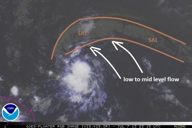
Btw, most of us know that SAL, the Saharan Air Layer (which contains a lot of Saharan dust) can "choke off" convection in a TC. But this system is a really good example of why a TC or developing TC can be right on the edge of a large area of SAL but not be affected by it. Notice that the SAL layer, outlined in brown, is being pushed away by the low to mid-level circulation of the TC itself. This is also aided by the fact that there's no shear from the north which could push the dust into the TC, and the system is moving quickly, which enhances the easterly and northerly winds on the north side of it, helping to keep the dust at bay.
This post is NOT AN OFFICIAL FORECAST and should not be used as such. It is just the opinion of the poster and may or may not be backed by sound meteorological data. It is NOT endorsed by any professional institution including storm2k.org. For Official Information please refer to the NHC and NWS products.

This post is NOT AN OFFICIAL FORECAST and should not be used as such. It is just the opinion of the poster and may or may not be backed by sound meteorological data. It is NOT endorsed by any professional institution including storm2k.org. For Official Information please refer to the NHC and NWS products.
0 likes
-
cycloneye
- Admin
- Posts: 149473
- Age: 69
- Joined: Thu Oct 10, 2002 10:54 am
- Location: San Juan, Puerto Rico
Re: ATL: INVEST 95L - Discussion
00z Best Track
AL, 95, 2013070800, , BEST, 0, 100N, 460W, 35, 1008, WV
AL, 95, 2013070800, , BEST, 0, 100N, 460W, 35, 1008, WV
0 likes
Visit the Caribbean-Central America Weather Thread where you can find at first post web cams,radars
and observations from Caribbean basin members Click Here
and observations from Caribbean basin members Click Here
-
Evil Jeremy

- S2K Supporter
- Posts: 5463
- Age: 32
- Joined: Mon Apr 10, 2006 2:10 pm
- Location: Los Angeles, CA
-
ozonepete
- Professional-Met
- Posts: 4743
- Joined: Mon Sep 07, 2009 3:23 pm
- Location: From Ozone Park, NYC / Now in Brooklyn, NY
Re: ATL: INVEST 95L - Discussion
cycloneye wrote:00z Best Track
AL, 95, 2013070800, , BEST, 0, 100N, 460W, 35, 1008, WV
Hmmm. That puts the center quite close to the developing convective concentration overhead. Also, it looks like this has started a jog to the west-northwest, which concurs with the NHC statement. That would bring it closer to the more northerly islands.
Personal Forecast Disclaimer:
The posts in this forum are NOT official forecast and should not be used as such. They are just the opinion of the poster and may or may not be backed by sound meteorological data. They are NOT endorsed by any professional institution or storm2k.org. For official information, please refer to the NHC and NWS products.
0 likes
-
ozonepete
- Professional-Met
- Posts: 4743
- Joined: Mon Sep 07, 2009 3:23 pm
- Location: From Ozone Park, NYC / Now in Brooklyn, NY
Re:
Evil Jeremy wrote:When was the last time the NHC initiated advisories on a system at 11pm? I don't recall anything of the sort happening in the past few years...
Good question. But they are running out of time for 48 hour notice...
0 likes
-
Gustywind
- Category 5
- Posts: 12334
- Joined: Mon Sep 03, 2007 7:29 am
- Location: Baie-Mahault, GUADELOUPE
Re: ATL: INVEST 95L - Discussion
ouragans wrote:Gustywind wrote:Here in Guadeloupe, no mention, no talk tv about this feature. Our Pro Mets of Meteo-France Guadeloupe expected an active twave crossing Guadeloupe Tuesday afternoon bringing strong showers and tstorms with gusts reaching 60 km/h.
what we don't have is Martinique's point of view, because I think they are more concerned than us in Guadeloupe. But as I know my martinican friends at Meteo-France Martinique, they must be sleeping as well
You're right
As usual, the citizens are not often well informed in these two islands...
0 likes
-
Cainer

- Tropical Storm
- Posts: 188
- Age: 34
- Joined: Mon May 05, 2008 3:26 pm
- Location: Yarmouth, Nova Scotia
Re:
Evil Jeremy wrote:When was the last time the NHC initiated advisories on a system at 11pm? I don't recall anything of the sort happening in the past few years...
Last time a first advisory was issued at 11 PM was for TS Florence last year, so 15 storms ago (but you're right that it doesn't happen very often).
0 likes
Who is online
Users browsing this forum: No registered users and 60 guests