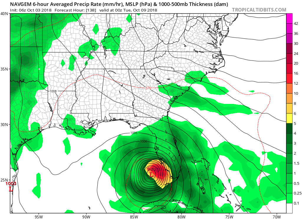
06Z GFS run has a closed off 1008 mb TC developng in the Bahamas Oct 10-11. It crosses South Florida :on 10/12, then emerges in the SE GOM as a 1002 mb TS 10/13.
One big note: It looks like 06Z GFS is finally showing the first major cold front of the season dropping southeast into the Eastern CONUS beginning 10/13.
Broad area of disturbed weather in the Western Caribbean Sea (Is INVEST 91L)
Moderator: S2k Moderators
Forum rules

The posts in this forum are NOT official forecasts and should not be used as such. They are just the opinion of the poster and may or may not be backed by sound meteorological data. They are NOT endorsed by any professional institution or STORM2K. For official information, please refer to products from the National Hurricane Center and National Weather Service.
-
northjaxpro

- S2K Supporter

- Posts: 8900
- Joined: Mon Sep 27, 2010 11:21 am
- Location: Jacksonville, FL
Re: Broad area of disturbed weather in the Western Caribbean Sea
0 likes
NEVER, EVER SAY NEVER in the tropics and weather in general, and most importantly, with life itself!!
________________________________________________________________________________________
Fay 2008 Beryl 2012 Debby 2012 Colin 2016 Hermine 2016 Julia 2016 Matthew 2016 Irma 2017 Dorian 2019
________________________________________________________________________________________
Fay 2008 Beryl 2012 Debby 2012 Colin 2016 Hermine 2016 Julia 2016 Matthew 2016 Irma 2017 Dorian 2019

Re: Broad area of disturbed weather in the Western Caribbean Sea
northjaxpro wrote:06Z GFS run has a closed off 1008 mb TC developng in the Bahamas Oct 10-11. It crosses South Florida :on 10/12, then emerges in the SE GOM as a 1002 mb TS 10/13.
One big note: It looks like 06Z GFS is finally showing the first major cold front of the season dropping southeast into the Eastern CONUS beginning 10/13.
I don't know if I would believe any model solutions with a strong cold front on it for the SE US with the ensembles continuing to show the NAO to stay positive especially with the PNA staying negative.
0 likes
-
northjaxpro
- S2K Supporter
- Posts: 8900
- Joined: Mon Sep 27, 2010 11:21 am
- Location: Jacksonville, FL
Re: Broad area of disturbed weather in the Western Caribbean Sea
Last edited by northjaxpro on Wed Oct 03, 2018 6:37 am, edited 1 time in total.
2 likes
NEVER, EVER SAY NEVER in the tropics and weather in general, and most importantly, with life itself!!
________________________________________________________________________________________
Fay 2008 Beryl 2012 Debby 2012 Colin 2016 Hermine 2016 Julia 2016 Matthew 2016 Irma 2017 Dorian 2019
________________________________________________________________________________________
Fay 2008 Beryl 2012 Debby 2012 Colin 2016 Hermine 2016 Julia 2016 Matthew 2016 Irma 2017 Dorian 2019
-
stormlover2013
Re: Broad area of disturbed weather in the Western Caribbean Sea
Models have shown cold fronts for the last 3 weeks and then it keeps pushing it back, I wouldn’t believe any models right now that’s why I said never believe anything starting at 5 days
0 likes

Re: Broad area of disturbed weather in the Western Caribbean Sea
06z FV3 similar idea to the GFS but much stronger than the GFS once it hits the Gulf and is back to the hard hook NE. I think the GFS & FV3 have the right idea now with the eastern vorticity takiing over and development happening outside the Carribean as it reaches the Bahamas/Florida Straits. I think the 00z Euro was playing catch up and will show a similar solution at the 12z back toward a Bahamas development scenario.
I think the 00z Ops run of the Euro was a bad run IMO. The ensembles on the Euro had more stronger members on the Eastern side so that should give us a clue for the 12z. I think the Western vorticity is now less likely to develop because of the significant land interaction.

I think the 00z Ops run of the Euro was a bad run IMO. The ensembles on the Euro had more stronger members on the Eastern side so that should give us a clue for the 12z. I think the Western vorticity is now less likely to develop because of the significant land interaction.
Last edited by blp on Wed Oct 03, 2018 6:41 am, edited 1 time in total.
2 likes
The following post is NOT an official forecast and should not be used as such. It is just the opinion of the poster and may or may not be backed by sound meteorological data. It is NOT endorsed by any professional institution including storm2k.org For Official Information please refer to the NHC and NWS products.
-
northjaxpro
- S2K Supporter
- Posts: 8900
- Joined: Mon Sep 27, 2010 11:21 am
- Location: Jacksonville, FL
Re: Broad area of disturbed weather in the Western Caribbean Sea
Who said I was believing the 06Z GFS stormlover..lol. I was just doing a quick wrap on what the run was depicting. Settle down ...
Last edited by northjaxpro on Wed Oct 03, 2018 6:51 am, edited 1 time in total.
2 likes
NEVER, EVER SAY NEVER in the tropics and weather in general, and most importantly, with life itself!!
________________________________________________________________________________________
Fay 2008 Beryl 2012 Debby 2012 Colin 2016 Hermine 2016 Julia 2016 Matthew 2016 Irma 2017 Dorian 2019
________________________________________________________________________________________
Fay 2008 Beryl 2012 Debby 2012 Colin 2016 Hermine 2016 Julia 2016 Matthew 2016 Irma 2017 Dorian 2019
-
stormlover2013
Re: Broad area of disturbed weather in the Western Caribbean Sea
blp wrote:06z FV3 similar idea to the GFS but much stronger than the GFS once it hits the Gulf and is back to the hard hook NE. I think the GFS & FV3 have the right idea now with the eastern vorticity takiing over and development happening outside the Carribean as it reaches the Bahamas/Florida Straits. I think the 00z Euro was playing catch up and will show a similar solution at the 12z back toward a Bahamas development scenario.
I think the 00z Ops run of the Euro was a bad run IMO. The ensembles on the Euro had more stronger members on the Eastern side so that should give us a clue for the 12z. I think the Western vorticity is now less likely to develop because of the significant land interaction.
https://image.ibb.co/b9PkJe/fv3p_mslp_wind_watl_fh150_240.gif
Models have changed everyday for the last 5 days till we get a center it will keep changing
0 likes

Re: Broad area of disturbed weather in the Western Caribbean Sea
It may not look like much but could be a sign of development.
A small vortical hot tower appears to have fired off very near or on the CoC of the mid-level vort.
A small vortical hot tower appears to have fired off very near or on the CoC of the mid-level vort.
0 likes

Re: Broad area of disturbed weather in the Western Caribbean Sea
Does anything show on the uk?
0 likes

-
Dean4Storms
- S2K Supporter
- Posts: 6358
- Age: 63
- Joined: Sun Aug 31, 2003 1:01 pm
- Location: Miramar Bch. FL
Re: Broad area of disturbed weather in the Western Caribbean Sea
Can anyone remember anytime in the past of a Tropical Disturbance sitting in the Western Carib. for at least a week in later Sept. through early to mid Oct. and it not go on to develop into a Tropical Cyclone? The Cyclone may have been heavily sheared or battled dry air but I cannot think of a time a disturbance has sat there and never became anything this time of year. So with that I think chances for at least a TS to develop are high. Exactly where it develops, when and how quickly it deepens remain big questions but with that big SE Ridge I can't see how it does not eventually become a GOM problem.
0 likes
-
SFLcane

- S2K Supporter
- Posts: 10281
- Age: 48
- Joined: Sat Jun 05, 2010 1:44 pm
- Location: Lake Worth Florida
Re: Broad area of disturbed weather in the Western Caribbean Sea
Dean4Storms wrote:Can anyone remember anytime in the past of a Tropical Disturbance sitting in the Western Carib. for at least a week in later Sept. through early to mid Oct. and it not go on to develop into a Tropical Cyclone? The Cyclone may have been heavily sheared or battled dry air but I cannot think of a time a disturbance has sat there and never became anything this time of year. So with that I think chances for at least a TS to develop are high. Exactly where it develops, when and how quickly it deepens remain big questions but with that big SE Ridge I can't see how it does not eventually become a GOM problem.
Actually with those cold-fronts progged by the models recently i think a move into the GOM is possible followed by NE movement towards the Florida peninsula. Not looking like much this morning and the NHC wording sounds like there not to far away from lowering development odds soon. We shall see
1 likes
-
stormlover2013
Re: Broad area of disturbed weather in the Western Caribbean Sea
SFLcane wrote:Dean4Storms wrote:Can anyone remember anytime in the past of a Tropical Disturbance sitting in the Western Carib. for at least a week in later Sept. through early to mid Oct. and it not go on to develop into a Tropical Cyclone? The Cyclone may have been heavily sheared or battled dry air but I cannot think of a time a disturbance has sat there and never became anything this time of year. So with that I think chances for at least a TS to develop are high. Exactly where it develops, when and how quickly it deepens remain big questions but with that big SE Ridge I can't see how it does not eventually become a GOM problem.
Actually with those cold-fronts progged by the models recently i think a move into the GOM is possible followed by NE movement towards the Florida peninsula. Not looking like much this morning and the NHC wording sounds like there not to far away from lowering development odds soon. We shall see
just remember models have showed a cold front long term for the last 3-4 weeks and a cold front hasn't been seen yet, its coming soon but models have always backed off when it was 3-4 day range, strong to the SE its going to depend where the center forms..
0 likes
-
p1nheadlarry

- Category 2

- Posts: 672
- Age: 34
- Joined: Wed Jan 29, 2014 2:42 pm
- Location: SR County FL
Re: Broad area of disturbed weather in the Western Caribbean Sea
Aric Dunn wrote:LarryWx wrote:All the 0Z Euro 108 hour map has is a very weak highly sheared low just NE of Yucatan tip moving W. Likely won't amount to much but let's see.
if you look at the 850 vorticity ( as everyone should be) you will see there is at least 3 vorticities. 1 major one the satellite vort that develops and another over central america. all the models except the CMC have these features is some form. they are all interacting with each other. 1 run a satellite vort gets thrown north into the bahamas the next run it rotates quickly nw .. we have a very unique set up right now and A LOT of variables the models are having some issues resolving. we ware going to have to wait and see where we get just 1 defined low pressure and things will start to become more clear. right now take it all with a grain of salt.
Any chances one of the vort maxes merge with one another? If the vorticity gradient is weak the interaction wouldn't be as strong. Would like to look at a cross section of the region.
1 likes
--;->#GoNoles--;->.
Re: Broad area of disturbed weather in the Western Caribbean Sea
SFLcane wrote:Dean4Storms wrote:Can anyone remember anytime in the past of a Tropical Disturbance sitting in the Western Carib. for at least a week in later Sept. through early to mid Oct. and it not go on to develop into a Tropical Cyclone? The Cyclone may have been heavily sheared or battled dry air but I cannot think of a time a disturbance has sat there and never became anything this time of year. So with that I think chances for at least a TS to develop are high. Exactly where it develops, when and how quickly it deepens remain big questions but with that big SE Ridge I can't see how it does not eventually become a GOM problem.
Actually with those cold-fronts progged by the models recently i think a move into the GOM is possible followed by NE movement towards the Florida peninsula. Not looking like much this morning and the NHC wording sounds like there not to far away from lowering development odds soon. We shall see
I don't think the odds have decreased. The Euro run had feedback issues like the GFS had. Plus the Euro ensembles did not change much and still show development. The 06z GFS has bounced back and I think has now aligned itself with the right area for cyclogenesis.
The one model that I am looking for is the Ukemt which really has not done much do to it's west bias but I am interested in the next few runs to see if changes. That would solidify the development chances a good deal.
0 likes
The following post is NOT an official forecast and should not be used as such. It is just the opinion of the poster and may or may not be backed by sound meteorological data. It is NOT endorsed by any professional institution including storm2k.org For Official Information please refer to the NHC and NWS products.
-
stormlover2013
Re: Broad area of disturbed weather in the Western Caribbean Sea
this is such a weird pattern, I mean that ridge in the SE is like summer lol i mean flat out crazy year this year
0 likes
-
Aric Dunn
- Category 5

- Posts: 21238
- Age: 43
- Joined: Sun Sep 19, 2004 9:58 pm
- Location: Ready for the Chase.
- Contact:
Re: Broad area of disturbed weather in the Western Caribbean Sea
p1nheadlarry wrote:Aric Dunn wrote:LarryWx wrote:All the 0Z Euro 108 hour map has is a very weak highly sheared low just NE of Yucatan tip moving W. Likely won't amount to much but let's see.
if you look at the 850 vorticity ( as everyone should be) you will see there is at least 3 vorticities. 1 major one the satellite vort that develops and another over central america. all the models except the CMC have these features is some form. they are all interacting with each other. 1 run a satellite vort gets thrown north into the bahamas the next run it rotates quickly nw .. we have a very unique set up right now and A LOT of variables the models are having some issues resolving. we ware going to have to wait and see where we get just 1 defined low pressure and things will start to become more clear. right now take it all with a grain of salt.
Any chances one of the vort maxes merge with one another? If the vorticity gradient is weak the interaction wouldn't be as strong. Would like to look at a cross section of the region.
One would think so. typically you dont see a prolonged interaction like the models are showing. one system or the other takes over, especially with all the land interaction. the models are just spitting out vorts all over the place and large one at that..
0 likes
Note: If I make a post that is brief. Please refer back to previous posts for the analysis or reasoning. I do not re-write/qoute what my initial post said each time.
If there is nothing before... then just ask
Space & Atmospheric Physicist, Embry-Riddle Aeronautical University,
I believe the sky is falling...
If there is nothing before... then just ask
Space & Atmospheric Physicist, Embry-Riddle Aeronautical University,
I believe the sky is falling...


-
stormlover2013
Re: Broad area of disturbed weather in the Western Caribbean Sea
yep until we have a true center this is what we will be getting.
0 likes
-
Aric Dunn
- Category 5
- Posts: 21238
- Age: 43
- Joined: Sun Sep 19, 2004 9:58 pm
- Location: Ready for the Chase.
- Contact:
Re: Broad area of disturbed weather in the Western Caribbean Sea
That is a pretty large spread in timing and overall playout...
just have to keep waiting until we have a decent low pressure to follow. another 24 hours depending on if we get some decent convection to maintain.
0 likes
Note: If I make a post that is brief. Please refer back to previous posts for the analysis or reasoning. I do not re-write/qoute what my initial post said each time.
If there is nothing before... then just ask
Space & Atmospheric Physicist, Embry-Riddle Aeronautical University,
I believe the sky is falling...
If there is nothing before... then just ask
Space & Atmospheric Physicist, Embry-Riddle Aeronautical University,
I believe the sky is falling...
Who is online
Users browsing this forum: Ulf and 132 guests